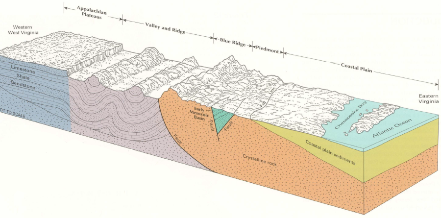
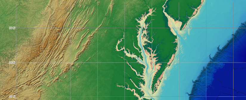
different bedrock shapes different topography, and helps define the physiographic regions of Virginia
Source: US Geological Survey (USGS), The Ground Water Atlas of the United States (HA 730-L, Figure 9)
different bedrock shapes different topography, and helps define the physiographic regions of Virginia
Source: US Geological Survey (USGS), The Ground Water Atlas of the United States (HA 730-L, Figure 9)
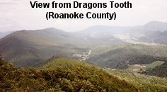
Geology helps to explain why mountains are high and valleys are low - and why mountains are in one place and valleys n a different lace. Geology helps explain why hikers can see a vista of mountains from the top of Dragons Tooth on the Appalachian Trail, why the Chesapeake Bay Bridge has two tunnels, and why the western part of the state is mountainous but the eastern part of Virginia is flat.
Understanding how the bedrock of a place developed over time requires applying some basic physics and chemistry. Bedrock varies across the state, and erodes at different rates. Climate, primarily temperature and rainfall, shapes the speed at which bedrock decomposes and new minerals form. Positively-charge ions of iron, magnesium, calcium, and other elements go into solution, leaving behind clay minerals. Roots penetrate the clay and organic material forms soil.
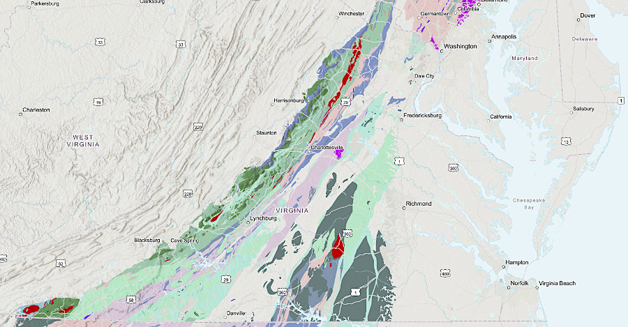
The state's major physiographic regions - Appalachian Plateau, Valley and Ridge, Blue Ridge, Piedmont, and Coastal Plain - reflect the patterns of bedrock.
Virginia is on the eastern edge of the North American continent - but we are not on the eastern edge of the North American tectonic plate. Virginia is closer to the middle of the tectonic plate than to the eastern edge. The eastern edge of the tectonic plate is the Mid-Atlantic Ridge in the middle of the Atlantic Ocean. The western edge is the San Andreas fault on the California coast, leaving Virginia in the middle.
There are constant earthquakes on the edges of the plate, where rock is oozing up to the surface (in the Mid-Atlantic Ridge) or rubbing against other plates (in California). Since Virginia is near the center, friction against other plates is minimal here - that's the main reason Virginias feel so few earthquakes.
"Few" is more than zero, of course. If you were in Northern Virginia during the afternoon of August 23, 2011, you felt a 10-20 second rumbling from a 5.8 magnitude earthquake centered near Mineral, Virginia. Items fell from bookshelves, cracks appeared in the Washington Monument, the nuclear reactors at North Anna were shut down, and many buildings in Washington DC and Richmond were evacuated.
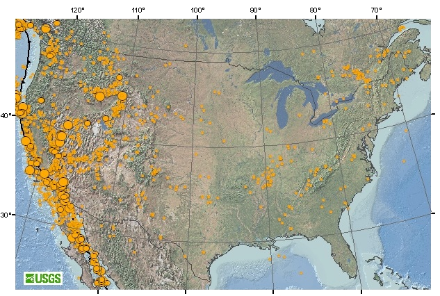
number/magnitude of earthquakes on east vs. west coasts
Source: US Geological Survey, Seismicity of the United States
Virginia wasn't always where it is today. Plate tectonics theory says we're moving west towards Japan at perhaps one inch (2.3cm or 23mm) per year. Different parts of North America are moving at different rates, and in slightly different directions. According to the UNAVACO Plate Motion Calculator, the Fairfax campus of George Mason University is moving at 14.49mm/year (1.5cm/year or 0.6 inches/year). The campus is heading north at 1.68mm/year and west at 14.39mm/year.1
According to other estimates, North America is moving at about one inch per year westward from the Mid-Atlantic Ridge. Human fingernails grow about 1.5" each year, slightly faster than the speed at which the North American plate moves away from the Mid-Atlantic Ridge. Each time we clip our fingernails, the length of what we cut off is roughly the distance the North American Plate has drifted to the west.
Human hair grows at two-three times the speed at which the tectonic plate is moving. Since Europe drifts the equivalent distance away from the Mid-Atlantic Ridge each year as North America, the Atlantic Ocean is widening at twice the rate that the North American Plate is drifting westward. The length of hair falling onto the floor during a haircut is roughly equivalent to the widening of the Atlantic Ocean since the last visit to the stylist/barber.
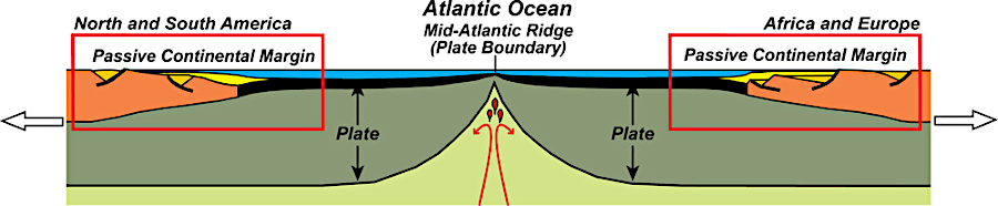
the North American and Eurasian tectonic plates are pushed apart as the seafloor spreads at the Mid-Atlantic Ridge
Source: National Park Service, Mature Ocean Basin Diagram
Measured in English units, one inch per year is almost a foot per decade, or roughly three yards each century. Since the Godspeed, Discovery, and Susan Constant first arrived in 1607, Jamestown has moved over 10 yards westward with continental drift - more than the length of a first down in an American football game.
Since the first immigrants from Asia walked into Virginia about 20,000 years ago, Virginia has drifted west from the Mid-Atlantic Ridge about the length of three football fields. In the last million years, Virginia has drifted 15-20 miles to the west as lava has flowed up at the Mid-Atlantic Ridge. The entire Atlantic Ocean between North America and Europe, with two plates drifting away from each other, has widened by 30-40 miles in the last million years.2
onshore topography and offshore bathymetry of Virginia with a wide Continental Shelf (light blue), the narrow Continental Slope further offshore, and the wider Abyssal Plain (deep blue) extending eastward towards the Mid-Atlantic Ridge
Source: NOAA's National Geophysical Data Center (NGDC) - ETOPO1 1 Arc-Minute Global Relief Model:
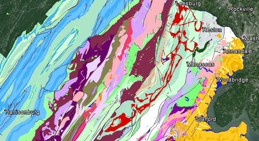
Virginia's bedrock consists of chunks that developed in place, plus migrant chunks of rock ("terranes") that moved around the earth to become part of Virginia. The patterns of bedrock, best portrayed in a graphic produced by Chuck Bailey at the College of William and Mary, reflect how different terranes were added ("accreted") to the edge of Virginia over the last 450 million years.
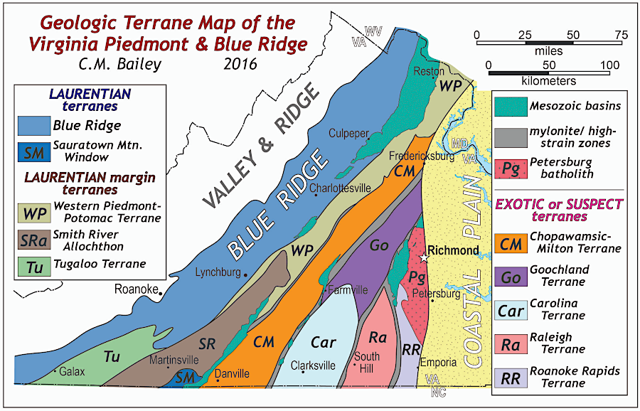
the bedrock of Virginia is composed of multiple terranes, including chucks of rock (exotic or suspect terranes) that migrated to Virginia
Source: College of William and Mary, Piedmont
The topography of Virginia was formed through a series of continental collisions that created vast mountain ranges in Virginia. The modern Blue Ridge and the "mountains" to the west are tiny, compared to the ancestral Appalachian Mountains created with Africa and North America collided 300 million years ago. The original Appalachian were located roughly where I-95 is located today, far east of the current Blue Ridge. Those original Appalachians may have been 20,000 feet high or higher.3
The collisions that created tall mountain ranges in Virginia were followed by erosion that has etched away those mountains. The eroded sediments have created the flat Appalachian Plateau west of Virginia, and the flat Coastal Plain east of I-95. The shorelines of the Atlantic Ocean and Gulf Coast have changed as the mountains washed away and as sea level has changed.
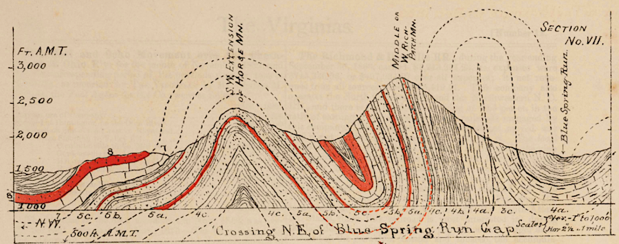
once-flat sedimentary layers have been folded by tectonic collisions, then eroded
Source: Mapping the Nation, Topographical Map of the Rich-patch Iron Region, Alleghany and Botetourt Counties, VA... (by Jedediah Hotchkiss, 1881)
Virginia is not as flat as a pancake today, despite 300 million years of rain and wind and gravity. Some ridges have resisted erosion, and "differential erosion" has created a low Shenandoah Valley adjacent to a high Blue Ridge. All those years of erosion should have worn Virginia down to a flat peneplain, but the key reason we have ridges today is recent uplift.
the North American tectonic plate has not eroded to a flat peneplain since Pangea broke up, so uplift is still exceeding erosion
Source: National Oceanic and Atmospheric Administration, GLOBE: A Gallery of High Resolution Images
Tectonic forces squeeze the North American Plate as it moves, creating stresses that might be pushing some rocks up. More significantly, the deeply-buried "roots" of the ancient Appalachians continue to float upward as erosion lowers the weight of the surface deposits above those roots.
In addition, parts of Virginia are moving up or down in response to the very recent disappearance of the Laurentide ice sheet. The last ice age ended only 18,000 years ago. The earth's crust in Pennsylvania is still rebounding upwards after the removal of the heavy weight of ice, and that rebound may be flexing the crust around Norfolk so it moves down. The downward motion is substantial enough to increase the threat of flooding as sea level rises.
To understand why there are individual ridges in some places and valleys in others, it helps to know the history of three major mountain-building events when chunks of silica-rich crust - even an entire continent - collided with Virginia. Since the locations of towns, highways, even soccer fields is determined in part by the geology of Virginia, it helps to understand the bedrock and the topography if you want to understand the people and the culture of the state. Could we have mountain music or "mountain dew" (moonshine whiskey) without mountains?
differential erosion between quartzite and limestone created mountains in the Valley and Ridge physiographic province - and McCoy Falls on the New River (Montgomery County)
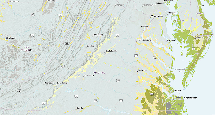
Virginia has multiple types of bedrock, from the limestones at Harrisonburg in the Shenandoah Valley (blue) to the sedimentary layers at Stafford on the Coastal Plain (yellow), with igneous/metamorphic zones in-between
Source: Google Earth, Geologic units of Virginia
Virginia's oldest rocks, deposited at least 541 million years ago before the Cambrian Period, are buried under younger sediments on the Coastal Plain east of I-95
Source: US Geological Survey (USGS), The Cooperative National Geologic Map
Virginia's most recent geological layers are sediments eroded off the Blue Ridge and deposited in river valleys during the Quaterary Period, in the last 2.6 million years
Source: US Geological Survey (USGS), The Cooperative National Geologic Map
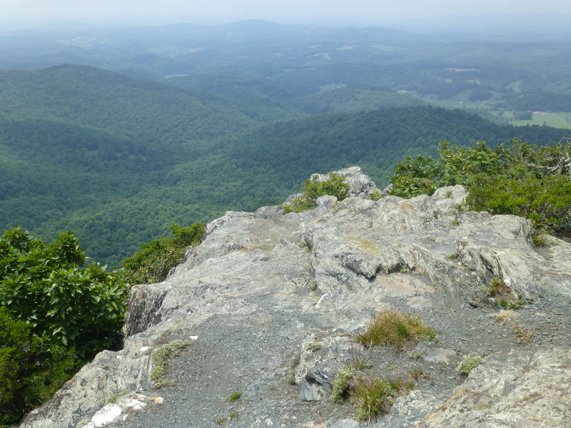
looking west from Buffalo Mountain (Floyd County)
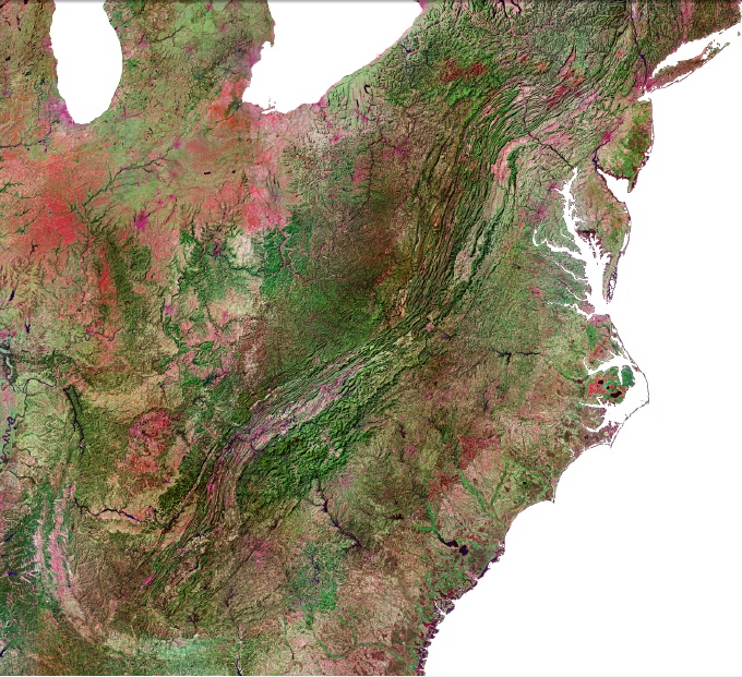
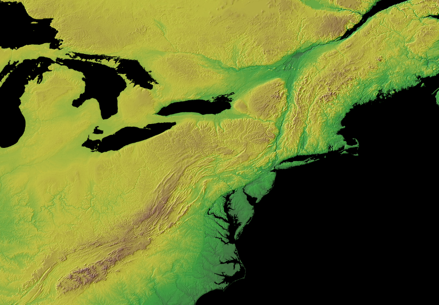
topography of Eastern United States
Source: National Atlas
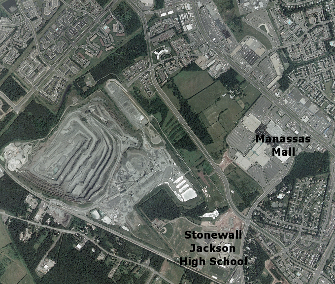
Vulcan Quarry, surrounded by suburbia west of Manassas
Source: National Agriculture Imagery Program, Manassas National Battlefield Park DOQ
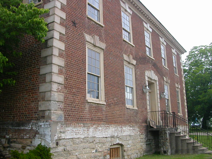
Williams Ordinary, historic colonial-era structure in Dumfries
with Aquia sandstone quoins on the corners to accent the brick walls
US211 cuts across the folded sandstone and shale layers that form erosion-resistant Massanutten Mountain, after crossing through the softer limestones in the Page Valley on the east near Luray
Source: National Aeronautics and Space Administration (NASA), Rocky Mount Fire, Virginia
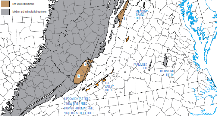
Virginia has coal deposits in the Triassic Basins of the Piedmont, the Valley and Ridge, and the Allegheny Plateau physiographic provinces
Source: University of North Carolina, The Great South; A Record of Journeys in Louisiana, Texas, the Indian Territory, Missouri, Arkansas, Mississippi, Alabama, Georgia, Florida, South Carolina, North Carolina, Kentucky, Tennessee, Virginia, West Virginia, and Maryland (1875)