The Chesapeake Bay "Bolide" That Shaped the Groundwater in Southeastern Virginia
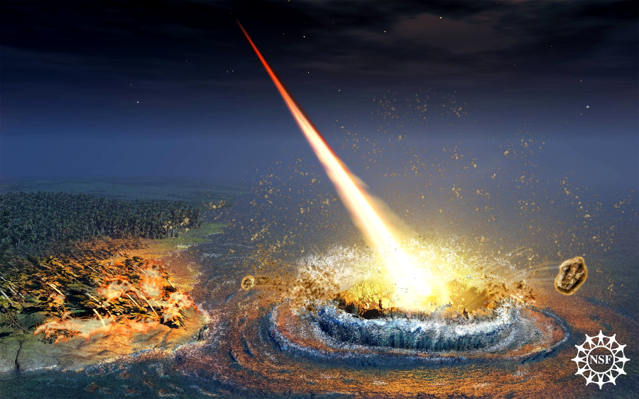
the bolide impact that occurred in the ocean 35 million years ago created a crater and generated a tsunami that swept across Virginia to the Blue Ridge
Source: National Science Foundation, Crumbling Walls of Ancient Chesapeake Bay Crater Threaten Regional Groundwater Supplies
The Earth formed by the collision of particles circling the Sun. The particles aggregated into a cloud, and the size of the planet expanded as the particles were drawn together by gravity. Current scientific thinking is that planets formed as the clouds circling the sun collapsed with very gentle collisions, creating pebbles that accreted into solid bodies of ever-increasing size until most particles had been consolidated, or through multiple high-energy impacts of planetesimal-sized bodies.
The dust cloud has to include heavy elements in order for dust grains and planetesimals to consolidate into planetary cores; dust clouds with just hydrogen and helium are dispersed by the radiation from a star. The heavy elements in a planet or rocky asteroid have been through at least one stellar explosion.
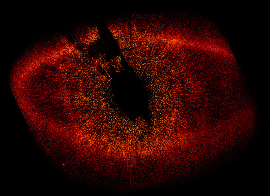
the Hubble Space Telescope has imaged the dust cloud circling the star Fomalhaut, where planets may be forming now
Source: National Aeronautics and Space Administration (NASA), HST ACS/HRC Wide View of Fomalhaut System
There were also many high-speed collisions as asteroids and comets, planetesimals that consolidated from out of cosmic dust grains into small bodies and slammed into the expanding planet. Violent impacts by such objects lasted through the Late Heavy Bombardment, ending 3.2 billion years ago. The craters of the moon show how the Earth's surface was once pockmarked with craters.
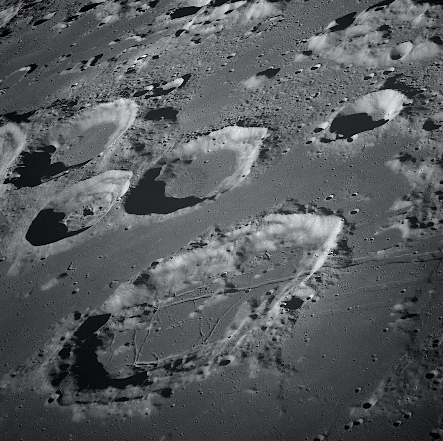
impact craters on the moon survive, in the absence of erosion and without recycling of tectonic plates
Source: National Aeronautics and Space Administration (NASA), View of Goclenius and Other Craters
Until 2025 the oldest known remaining impact structure, 2.2 billion year old, was at Yarrabubba in Western Australia. Until that crater's discovery, the 2.0 billion year old, 190-mile-wide Vredefort Dome crater in South Africa was thought to be the oldest remaining on Earth. More recently, a 3.5 billion-year-old crater 62 miles wide was identified 660 miles away in the East Pilbara Terrane.
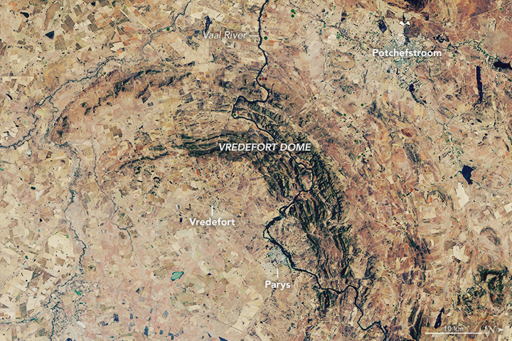
the second-oldest known impact crater on Earth is the Vredefort Dome in South Africa
Source: National Aeronautics and Space Administration (NASA), Vredefort Crater
The Earth formed 4.5 billion years ago, and no craters are known from the first half of the plant's existence. The oldest impact craters, including all of those from the Late Heavy Bombardment, have disappeared. Erosion and crustal recycling by subduction of tectonic plates has reshaped the surface. Since almost all ocean crust is less than 200 million years old, all of the ancient craters are found on continental crust and there are no ancient craters waiting to be discovered underwater.
As Earth was forming, it was struck by many "giant impactors" the size of the 6.2 mile (10 kilometer) wide asteroid that created the Chicxulub crater and wiped out the dinosaurs 66 million years ago. During the Archeon Era from 4.0-2.5 billion years ago, such impacts occurred on average every 15 million years.
Geologists have found evidence of 16 major impact events during the Archeon Era. The S2 meteorite that struck 3 billion years ago, creating what is called today the Fig Tree Group of rocks in South Africa, was 23-36 miles wide. That makes it 50-200 times larger that the Chicxulub asteroid. The S2 impact boiled off the top layer of the ocean and brought iron-rich deep-water to the surface. That increased iron hydroxide and may have stimulated the development of single-celled organisms, which benefitted from the additional iron plus phosphorus washed off the few chunks of dry land at the time.
In the last 650 million years, the earth had been struck about 355 times by a "bolide" (asteroid or comet) large enough to form a crater at least 20 kilometers (12 miles) in diameter. Scientists estimate that there have been between 269-441 such impacts over the last 650 million years.
Craters were formed when an impactor was no more that 1% of the size of the Earth. Collisions with a larger body would have melted a portion of the Earth's surface. In the unusual case of the collision between Earth and a Mars-sized called Thea, the impact disrupted the mantle and created the moon.
Today, only 38 (plus or minus 6) of the large impact craters are clearly visible. One is the Deniliquin structure in Australia. It may mark the site of an impact 440 million years ago that caused so many extinctions of species that geologists mark that date to separate the Ordovician from the Silurian Period. The Deniliquin structure may be the largest remaining impact site Earth.
In addition to remnants of large impacts, there are smaller structures still recognizable as well. The Middlesboro Basin in Kentucky, just across the border from Cumberland Gap, includes an impact structure that is 5.5 kilometers in diameter. An asteroid 700 feet wide cracked the Earth's crust around 300 million years ago, killing everything within 20 miles. The impact created arc-like faults that are distinctly different from the traditional straight alignment of faults on the Allegheny Plateau. Erosion later carved the current 3.5 mile wide bowl in which the town of Middlesboro is located, and weaknesses in the bedrock led to the formation of Cumberland Gap.
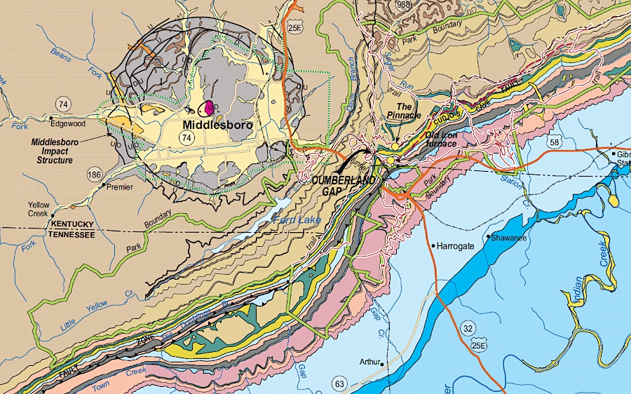
the Middlesboro Basin was formed by an impact about 300 million years ago, and has survived despite orogenies and erosion
Source: Kentucky Geological Survey, Geology of Cumberland Gap National Historical Park
Impact craters are still being identified. A 20-mile wide crater in Greenland, covered by the ice sheet, was identified in 2022 as 58 million years old.
A surprisingly low percentage of impact structures at least 20 kilometers (12 miles) in diameter date from 650-250 million years in age. From the Cambrian explosion of multicellular life to the formation of the Appalachian Mountains, for unknown reasons there were fewer objects in near earth orbit that crashed into the earth. For the last 250 million years, the risk of major impacts has been greater.1
All 21 known impact craters that formed during the Ordovician Period are within 30 degrees of the Equator. That unusual concentration may have been caused after the Earth's gravity captured an asteroid around 450 million years ago. That asteroid, stressed by Earth's gravity, then broke up while in orbit. Initially the remains of the asteroid would have formed rings comparable to those around Saturn today. Over time, the remnants spiraled in and collided with the Earth, and some chunks were large enough to leave impact craters.
The most famous collision of an asteroid with the Earth was 66 million years ago. The Chicxulub impact into what is now the Yucatan Peninsula led to the extinction of dinosaurs. Vaporized rock and debris cooled into spherules of hot glass that rained back onto the earth's surface. Animals not in underground burrow or underwater will killed directly; other died from the resulting forest and grass fires worldwide. Dust in the atmosphere blocked the sun and created a "nuclear winter," cutting off vegetation growth and causing species to go extinct.
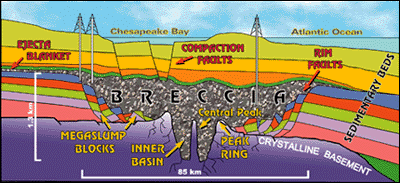
The Chicxulub crater formed by the impact was about 100 miles wide and nearly 20 miles deep, before sediments washed back into it. The dynamic collapse formed a "peak ring" of sediments, a circular ridge inside the crater rim at the impact site:2
- The peak ring formed in a matter of minutes. Just after the impact, deep granite bedrock, flowing like a liquid, rebounded into a central tower as tall as 10 kilometers before collapsing into the circular ridge. Next, the peak ring was covered by a layer of jumbled-up rocks, called a breccia, that contains chunks of blasted-up rock and impact melt. Then, in the hours that followed, ocean tsunamis dumped huge amounts of sandy sediment in the giant hole in Earth. Further deposition would come slowly, as life returned to the seas, and layers of limestone were built up in the ensuing millions of years.
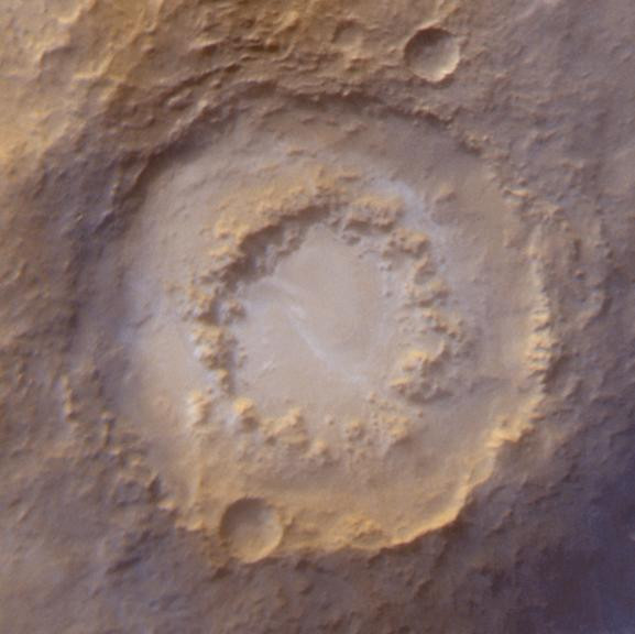
the Chicxulub impact created a peak ring like those seen on other planets, such as the Lowell crater on Mars
Source: National Aeronautics and Space Administration (NASA), PIA02836: The Frosted Craters of Northern Spring and Southern Autumn - Lowell Crater
Virginia has a smaller version of the Chicxulub impact crater, with a smaller peak ring.
About 35 million years ago, a bolide about 1-3 miles wide slammed into the ocean off the eastern edge of the North American continent. The bolide penetrated through 600-1,500 feet of water of the Atlantic Ocean until reaching the Continental Shelf. It cut through 1,800-3,000 feet of unconsolidated sediments, and after reaching the granite crust it kept digging until the kinetic energy was diffused.
In addition to vaporizing/displacing water and sediments and then excavating a hemispherical cavity in the crystalline basement, the impact disrupted the nearby sediments on the continental shelf and created fractures that went as deep as seven miles. The bolide superheated and evaporated into gas. If the impact was similar to what happened at the Mistastin crater, which formed 36 million years ago in what is now Canada, rock in the crater was heated to over 4,000°F That is hotter than much of the mantle beneath the crust today.
A plume of melted and ejected bedrock, plus the material that did evaporate, rose up in a towering cloud 15-30 miles high. Some debris transformed by the impact was scattered as far as the Continental Shelf off the coast of New Jersey. Geologists exploring there for oil and gas discovered "tektites" (tiny glass beads) and "shocked quartz" in the 1980's, finding the critical clue that there was an impact crater nearby. The specific site of the Chesapeake Bay impact crater, near Cape Charles, was not discovered and described in the scientific literature until the 1990's.
After the bolide hit 35 million years ago, most debris fell back to earth near the site of the impact.
Some ejected debris fell back into the crater. Some of the molten material arched through the sky and killed all life wherever the shards landed on the surface. Hurricane-force winds in the superheated atmosphere triggered firestorms across Virginia's Piedmont.
Underwater, seawater trapped between debris particles was extra salty. The heat had evaporated much of the water at the site of impact, making the remainder hypersaline.
As water rushed back into the crater, fluidized sediments at the edge of the crater slumped and expanded the size of the crater far beyond the first "hole" in the crust created by the impact. The crater's initial width, two seconds after impact, was 17 miles, but it soon widened to 25 miles (40 kilometers).
The disrupted sediments inside and around the crater formed a new layer now known as the Exmore breccia.3
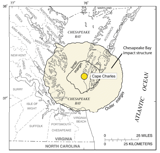
the bolide central crater and "annular ring" outside
Source: US Geological Survey (USGS) - Professional Paper 1622, The Effects of the Chesapeake Bay Impact Crater on the Geologic Framework and the Correlation of Hydrogeologic Units of Southeastern Virginia, South of the James River
The impact location 35 million years ago was in the Atlantic Ocean off the eastern edge of Virginia, when sea levels were higher and the shoreline was west of modern I-95 There was no Chesapeake Bay or Eastern Shore at the time. The Chesapeake Bay itself did not form until after the Wisconsin glaciation ice sheet melted 18,000 years ago.
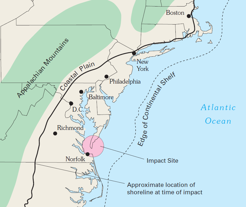
the bolide crashed into the Atlantic Ocean, when water levels were much higher
Source: US Geological Survey (USGS) - Circular 1262, Ground Water in Freshwater-Saltwater Environments of the Atlantic Coast (Figure 16)
The impact created a wave of water perhaps 1,500 feet high. As described in the Richmond Times Dispatch, the impact created a massive tsunami:4
- The waves nearly overlapped the Blue Ridge Mountains before washing back into the horrible gash, then covered the superheated water beneath a thick blanket of debris, rock and sediment. Over time, as this new geologic formation settled, it set the stage for Virginia's baffling coastal groundwater system, with its pockets of salty groundwater. USGS geologist Wylie Poag, another co-discoverer of the bay's ancient depression, has called it "probably the most dramatic geological event that ever took place on the Atlantic margin of North America."
Evidence of the tsunami has been found in sediments of Moore County, North Carolina, 240 miles southwest of the impact site. The first solid evidence of the massive wave was buried 10' deep in the the Paint Hill rock formation. Ash, glass formed from the heat of the impact, and fragments of once-deep bedrock were found in a jumbled sediment layer. All other sedimentary layers above and below had been deposited relatively gently by slow erosion, so a catastrophic event was the cause. The high percentage of iridium in that layer indicated an extraterrestrial object was involved.
Four different sedimentary beds were identified at the Moore County site. They included deposits of pulverized rock ejected by the initial impact together with carbon from organic material incinerated by the heat, atmospheric fallout deposits as the plume of material blasted into the air settled back to earth, and the initial tsunami surge of water pushed out by the 2-3 mile wide bolide slamming into the earth at 44,000 miles per hour.
Layer 4 at the top was probably from the tsunami waves that washed over the land. It included sediments laid down as water sloshed back and forth into the cavity in the Atlantic Ocean and seafloor created by the impact, then bouncing back after the water rushed to the Blue Ridge.
An Old Dominion University geologist concluded the virtually everything living on the surface east of modern-day Lynchburg was obliterated in just a few moments:5
- There was a kill zone that would have been several hundred miles out in every direction.
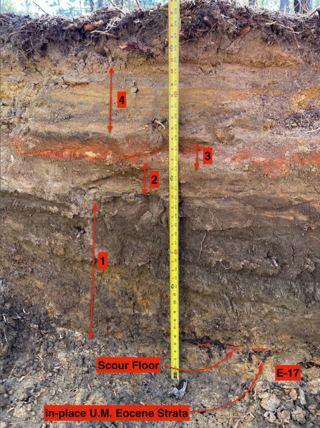
Layer 4 at the top was probably deposited by tsunami waves, following deposition of three earlier layers right after the impact
Source: Southeastern Geology, Evidence for Distal Bolide Impact and Tsunami Deposits in the Upper Atlantic Coastal Plain of Moore County (North Carolina, USA) generated by the Eocene Chesapeake Bay Bolide Impact (Figure 4)
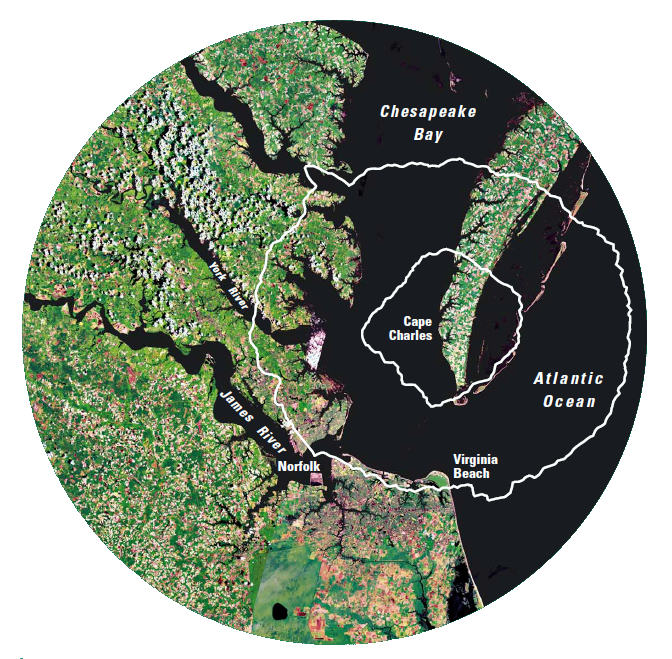
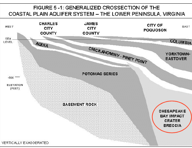
Over the last 35 million years, gravel, sand, silt, and clay deposited by shifts in the path of the Susquehanna River have formed the Eastern Shore peninsula. Today the Exmore breccia is 1,500 feet deep below the surface of the Eastern Shore peninsula, and the center of the impact crater is underneath the southern tip of Northampton County. Because land has continued to subside within the crater over the last 35 million years, the western edge of the crater is still visible in topographic maps.6
the western edge of the bolide crater is still evident 35 million years later, because land inside the crater is subsiding faster
Source: US Geological Survey (USGS), The National Map
Impact craters are rare on the earth, in part because crust is recycled by tectonic forces and in part because so much of the Earth's surface is covered by water. Bolides that land in the ocean must penetrate through the water column in order to carve out a crater.
When they strike, tsunamis form in two stages. First, a "rim wave" is created when the water/earth ejected from the crater falls back into the ocean. Second, water rushes back into the hole created by the passage of the bolide. That "collapse wave" creates a jet of water erupting in the center. Several cycles of collapse waves may occur.7
The Chesapeake Bay impact was a dramatic event, but the Chicxulub crater was formed by an impactor perhaps 2-3 times larger. The Chicxulub crater is over 100 miles in diameter. As happened with the Chesapeake Bay crater, sediments also covered the site of the Chicxulub crater, burying it partially under the Yucatan peninsula in Mexico.
The larger asteroid that created the Chicxulub crater 66 million years ago altered the global climate, leading to the rise of mammals after the extinction of dinosaurs. The smaller bolide that impacted in the Atlantic Ocean off the Virginia coast 35 million years ago had dramatic impacts locally, but did not trigger climate change with global effects. A similar impact about the same time in what is now Russia created the Popigai crater. That impact also had just local impacts, including the creation of tiny diamonds in a ring 7-8 miles from the impact site as flakes of graphite were transformed into crystals.8
sediments exposed on Coastal Plain in eastern Virginia were deposited primarily in Miocene/Pliocene epochs, after the bolide impact in the Eocene
Source: US Geological Survey (USGS) - Professional Paper 1680,
A Surficial Hydrogeologic Framework for the Mid-Atlantic Coastal Plain (Plate 2)
The Chesapeake Bay impact created a zone of weakened rock. That may have shaped the direction of the Susquehanna River and James River as they carved their channels to the Atlantic Ocean, ultimately affecting the location of the Chesapeake Bay. As noted by the Chesapeake Bay Impact Crater geologists:9
- The rivers of the Chesapeake region converged at a location directly over the buried crater. In short, the impact crater created a long-lasting topographic depression, which helped determine the eventual location of Chesapeake Bay.
However, the bolide did NOT scoop out a depression and form the current Chesapeake Bay overnight. The impact was 35 million years ago, while the bay formed much more recently.
The Chesapeake Bay evolved over just the last 10,000 or so years, as sea levels rose and flooded the valleys of the Susquehanna and James rivers. By that time, several hundred feet of sediment had buried the crater.
The location of those river channels (and the modern Chesapeake Bay) was affected by the much-older depression created initially by the bolide. The impact was a one-day event, but subsidence may have continued gradually over the last 35 million years. If the sediments deposited in the crater continued to subside, the low spot in the crust of the earth affected the route of the James River and Susquehanna River channels.
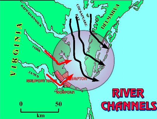
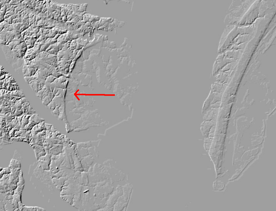
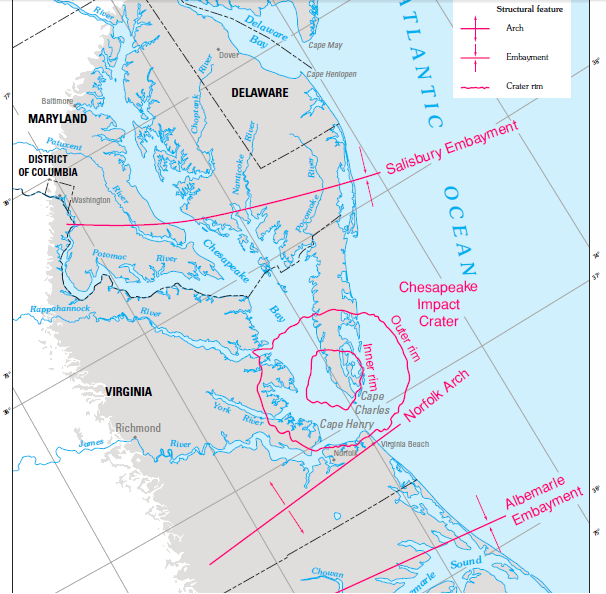
path of Susquehanna River and sharp changes in direction of James and York rivers
at edge of crater show how modern river channels were shaped by the bolide impact 35 million years ago
Source: The Chesapeake Bay Bolide: Modern Consequences of an Ancient Cataclysm
Far more than the earth's surface above the crater, groundwater today is affected dramatically by the ancient impact. The U.S. Geological Survey drilled a test hole 2,699 feet deep into the impact crater near Cape Charles, Virginia, during May/June 2004. Ground-water salinity in the well was saltier than sea water (35 parts of salt per thousand parts of water), reaching 40 parts per thousand.10
Between September 2005 and May 2006, the Chesapeake Bay Impact Structure Deep Drilling Project drilled again into the crater at a location about 4 miles north of the town of Cape Charles, at Eyreville Farm. The geologists drilled through post-impact sediments (those less than 35 million years old), then through the "breccia" (shattered rock created when the bolide smashed through the water column and into the ocean bottom), and finally reached the crystalline basement rocks more than one mile below the surface.
The deepest of three wells dug there reached 1,766 meters (5,794 feet, over a mile deep into the ground). They ran into granite rock at a shallow depth, greatly complicating what they expected to be drilling through soft sediments of the Coastal Plain. After deciding that the hole was too shallow to have struck bedrock below the sediments, they kept drilling. After drilling through 900 feet of granite, they broke through it and encountered the expected breccia, the broken pieces of bedrock mixed with sediments.11
It appears the bolide tossed a big chunk of granite into the air at impact, 35 million years ago. The geologists had the misfortune to pick the location where that boulder had landed for their drilling project.
how the impact fractured the bedrock
Source: USGS Fact Sheet 049-98:
The Chesapeake Bay Bolide Impact: A New View of Coastal Plain Evolution
The dramatic disruption of the bedrock layers "entrained" hypersaline water in some places underneath what is now the Eastern Shore and Hampton Roads. As the debris fell back from the impact, it sealed off aquifers where the heat of the impact had evaporated some of the seawater, trapping extra-salty pools of water underground. The "inland salt-water wedge" of unusually salty groundwater in the crater basin has a thin lens of freshwater on top, with freshwater in the sediments which were deposited after the impact but extra-salty groundwater underneath in the remains of the crater.
aquifers that could supply groundwater in Newport News area
Source: City of Poquoson Comprehensive Plan 2008-2028
The Hampton Roads region is limited to extracting a limited amount of fresh water from the more-recent sediments deposited over the last 35 million years. The disruption of the bedrock layers has greatly complicated efforts of Newport News to find a reliable supply of fresh drinking water. The city plans for substantial growth in demand for fresh water, but is unable to extract a sufficient supply from groundwater. The City of Poquoson gets its fresh water from Newport News, and notes in their Comprehensive Plan how the Lower, Middle, and Upper Potomac aquifers were affected:12
- The impact of the bolide obliterated the deepest three aquifers beneath the Chesapeake Bay, the Eastern Shore, and portions of the Lower and Middle Peninsula.
The James River runs right next to Newport News. There is plenty of water, but at that location in Tidewater, the river is brackish. It is too salty to drink without expensive treatment. As a result, Newport News tried to build a surface reservoir in King William County, damming Cohoke Creek and (since the creek's watershed is so small) pumping fresh water from the Mattaponi River into that reservoir. Ultimately, after great political debate and multiple lawsuits, the proposed King William Reservoir was blocked by the Federal government.
The bolide that impacted 35 million years ago affected what is now the Eastern Shore, Chesapeake Bay, and Hampton Roads. However, Lake Drummond and other crater-like features on the Coastal Plain of southeastern Virginia were created by a totally different process within more-recent times. The Carolina Bay depressions are unrelated to the Chesapeake Bay bolide impact.13
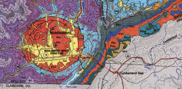
a bolide struck over 300 million years ago near modern-day Cumberland Gap, and the town of Middlesboro (Kentucky) developed in that crater
Source: US Geological Survey (USGS), Geologic map of the Middlesboro and part of the Bristol 30 x 60 minute quadrangles, southeastern Kentucky (2004)
Links
- Correlating the Orientation of Carolina bays to a Cosmic Impact
- Earth Impact Database
- Geotimes
- Lunar and Planetary Institute
- Prince William County Schools
- Scientific Drilling
- US Geological Survey (USGS)
- William and Mary - Geology of Virginia
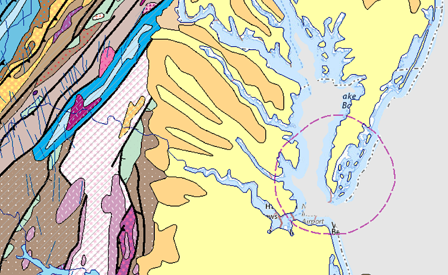
the crater formed by a bolide's impact 35 million years ago stops short of Tangier Island on its northern end
Source: US Geological Survey (USGS), The National Map
References
1. William Bottke, Sara Mazrouei, Rebecca Ghent, Alex Parker, "What Really Happened to Earth's Older Craters?,"
American Astronomical Society, October 2017, https://ui.adsabs.harvard.edu/abs/2017DPS....4910003B/abstract; Charles O'Dale, "Middlesboro Impact Crater," Crater Explorer, http://craterexplorer.ca/middlesboro-impact-crater/; "There's a second impact crater under Greenland," Astronomy, February 13, 2019, https://astronomy.com/news/2019/02/theres-a-second-impact-crater-under-greenland; "Huge asteroid slammed into Greenland just a few million years after the dinosaurs died out," Space, March 10, 2022, https://www.space.com/greenland-impact-crater-hiawatha-age; "New evidence suggests the world's largest known asteroid impact structure is buried deep in southeast Australia," The Conversation, August 9, 2023, https://theconversation.com/new-evidence-suggests-the-worlds-largest-known-asteroid-impact-structure-is-buried-deep-in-southeast-australia-209593; "How the world's oldest known meteorite impact structure changed the chemistry of Earth's crust," The Conversation, April 11, 2023, https://theconversation.com/how-the-worlds-oldest-known-meteorite-impact-structure-changed-the-chemistry-of-earths-crust-201228; "NASA Determines Australian Meteor Crater is the Oldest Known," National Aeronautics and Space Administration (NASA), January 21, 2020, https://www.nasa.gov/feature/nasa-determines-australian-meteor-crater-is-the-oldest-known; "Ancient craters teach us Earth's history, but scientists can't find them," Washington Post, August 9, 2023, https://www.washingtonpost.com/climate-environment/2023/08/09/earth-impact-craters-vanishing-erosion/; "Heavy Elements Key for Planet Formation, Study Suggests," Space, April 19, 2012, https://www.space.com/15341-planet-formation-stars-heavy-elements.html; "The Earth's gentle start," Axios, March 3, 2020, https://www.axios.com/2020/03/03/earth-formation-gentle; Travis S.J. Gabriel, Saverio Cambioni, "The Role of Giant Impacts in Planet Formation," Annual Review of Earth and Planetary Sciences, Volume 51 (May 31, 2023), https://doi.org/10.1146/annurev-earth-031621-055545; "A giant meteorite boiled the oceans 3.2 billion years ago. Scientists say it was a 'fertilizer bomb' for life," CNN, October 22, 2024, https://www.cnn.com/2024/10/22/science/ancient-meteorite-s2-impact-early-earth-life/index.html; Nadja Drabon, Andrew H. Knoll, Donald R. Lowe, David A. Mucciarone, "Effect of a giant meteorite impact on Paleoarchean surface environments and life," PNAS, October 21, 2024, https://doi.org/10.1073/pnas.2408721121; "Earth's oldest meteorite crater found in Australia," Popular Science, March 7, 2025, https://www.popsci.com/science/oldest-crater-on-earth/; "The story behind the crater," Middlesboro News, February 2, 2023, https://middlesboronews.com/2023/02/02/the-story-behind-the-crater/ (last checked March 27, 2025)
2. "Earth ring theory may shed light on an unexplained ancient climate event, scientists say," CNN, November 18, 2024, https://www.cnn.com/2024/11/18/science/earth-saturn-ring-asteroid-study; Andrew G. Tomkins, Erin L. Martin, Peter A. Cawood, "Evidence suggesting that earth had a ring in the Ordovician," Earth and Planetary Science Letters, Volume 646, November 15, 2024, https://doi.org/10.1016/j.epsl.2024.118991; "Updated: Drilling of dinosaur-killing impact crater explains buried circular hills," Science, November 17, 2016, https://www.science.org/content/article/updated-drilling-dinosaur-killing-impact-crater-explains-buried-circular-hills; "Shards of Asteroid That Killed the Dinosaurs May Have Been Found in Fossil Site," New York Times, April 7, 2022, https://www.nytimes.com/2022/04/07/science/asteroid-killed-dinosaurs-fossil-site.html (last checked November 23, 2024)
3. "The Chesapeake Bay Bolide Impact: A New View of Coastal Plain Evolution," US Geological Survey, USGS Fact Sheet 049-98, 1998, https://pubs.usgs.gov/fs/fs49-98/; "Chesapeake Bay Crater Offers Clues to Ancient Cataclysm," National Geographic, November 13, 2001, http://news.nationalgeographic.com/news/2001/11/1113_chesapeakcrater.html; Gareth S. Collins, Kai Wunnemann, "How big was the Chesapeake Bay impact? Insight from numerical modeling," Geology, Volume 33, Number 12 (December 2005),
https://pubs.geoscienceworld.org/geology/issue/33/12; "Massive meteorite impact created the hottest mantle rock ever," Live Science, April 18, 2022, https://www.livescience.com/hottest-rock-on-earth-mantle (last checked April 20, 2022)
4. "Drill explores blast: Research seeks insight into explosion that carved huge crater under the Chesapeake," Richmond Times Dispatch, September 8, 2005 (no longer available online); "Effects of Ancient Meteor Impacts Still Visible on Earth Today," Space.com, September 23, 2013, https://www.space.com/22909-ancient-asteroid-impacts-earth-effects.html (last checked October 10, 2019)
5. "Geologists uncover new evidence from ancient asteroid that hit the Chesapeake Bay," Virginia Mercury, July 4, 2025, https://virginiamercury.com/2025/07/04/geologists-uncover-new-evidence-from-ancient-asteroid-that-hit-the-chesapeake-bay/; G. Ganis, Ralph Willoughby, David Cicimurri, G. Whittecar, Steven Hageman, "Evidence for Distal Bolide Impact and Tsunami Deposits in the Upper Atlantic Coastal Plain of Moore County (North Carolina, USA) generated by the Eocene Chesapeake Bay Bolide Impact," Southeastern Geology, Volume 55 (May 2025), https://www.researchgate.net/publication/391903518_Evidence_for_Distal_Bolide_Impact_and_Tsunami_Deposits_in_the_Upper_Atlantic_Coastal_Plain_of_Moore_County_North_Carolina_USA_generated_by_the_Eocene_Chesapeake_Bay_Bolide_Impact (last checked July 4, 2025)
6. "Geologic Columns for the ICDP-USGS Eyreville A and C cores, Chesapeake Bay impact structure: Postimpact sediments, 444 to 0m depth," in The ICDP-USGS Deep Drilling Project in the Chesapeake Bay Impact Structure: Results from the Eyreville Core Holes, Special Paper 458, The Geological Society of America, 2009
7. K. Wünnemann, R. Weiss, "The meteorite impact-induced tsunami hazard," em>Philosophical Transactions - Series A, Mathematical, Physical, and Engineering Sciences, 373, September 2015, http://dx.doi.org/10.1098/rsta.2014.0381 (last checked October 24, 2017)
8. Takafumi Matsui, F. Imamura, Eiichi Tajika, Y. Nakano, Y. Fujisawa, "Generation and propagation of a tsunami from the Cretaceous-Tertiary impact event," in Catastrophic events and mass extinctions: impacts and beyond, Christian Koeber, Kenneth G. MacLeod (editors), Geological Society of America Special Papers Volume 356, 2002, p.70, https://dx.doi.org/10.1130/0-8137-2356-6.69; "2 huge asteroid strikes 36 million years ago didn't change Earth's climate over the long haul, study finds," Space, December 11, 2024, https://www.space.com/the-universe/asteroids/2-huge-asteroid-strikes-36-million-years-ago-didnt-change-earths-climate-over-the-long-haul-study-finds ; "Russia's Crater of Diamonds," NASA Earth Observatory, https://earthobservatory.nasa.gov/images/148403/russias-crater-of-diamonds; "Diamonds Beneath the Popigai Crater - Northern Russia," Geology.com, https://geology.com/articles/popigai-crater-diamonds/ (last checked December 14, 2024)
9. "The Chesapeake Bay Bolide Impact: A New View of Coastal Plain Evolution," US Geological Survey Fact Sheet 049-98, 1998, http://marine.er.usgs.gov/fact-sheets/fs49-98/ (last checked August 390, 2012)
10. Gregory S. Gohn, Ward E. Sanford, David S. Powars, J. Wright Horton, Jr., Lucy E. Edwards, Roger H. Morin, Jean M. Self–Trail, "Site report for USGS test holes drilled at Cape Charles, Northampton County, Virginia, in 2004," Open File Report 2007-1094, 2007, p.12, https://pubs.usgs.gov/of/2007/1094/ (last checked October 10, 2019)
11. "Chesapeake Bay Impact Structure Deep Drilling Project Completes Coring," Scientific Drilling, No. 3, September 2006, http://rockbox.rutgers.edu/p38-41_Chesapeake.pdf (last checked September 8, 2008)
12. "City of Poquoson Comprehensive Plan 2008-2028," CHAPTER 5- NATURAL RESOURCES ELEMENT, Section III: Ground Water Sub-element, p.5-42, http://www.ci.poquoson.va.us/sites/default/files/CompPlan03.22.10_0.pdf (last checked January 1, 2013)
13. "Carolina Bays," South Carolina Department of Natural Resources, https://www.dnr.sc.gov/geology/carolina-bays.html; "The Fiery Origins of Carolina Bays," Coastal Review, August 13, 2013, https://coastalreview.org/2013/08/the-fiery-origins-of-carolina-bays/ (last checked December 30, 2023)
Source: Open-File Report 2007-1094, Site report for USGS test holes
drilled at Cape Charles, Northampton County, Virginia, in 2004
deep geologic structure of eastern Virginia
Source: US Geological Survey (USGS) - Professional Paper 1680,
A Surficial Hydrogeologic Framework for the Mid-Atlantic Coastal Plain (Plate 2)
Rocks and Ridges
Virginia Places