the Blue Ridge was buried 6-10 miles deep at one time, before being exposed by erosion over the last 300 million years
Source: Department of Justice
the Blue Ridge was buried 6-10 miles deep at one time, before being exposed by erosion over the last 300 million years
Source: Department of Justice
The core of the Blue Ridge is the basement rock of Virginia, the bedrock that is thought to lie beneath all other rocks of the state from the edge of the ocean to the borders with West Virginia/Kentucky.
That basement igneous rock formed during the Grenville Event (or events, perhaps involving multiple continental collisions) between 1.1-1.0 billion years ago, as tectonic plates combined to form the supercontinent of Rodinia.1
The heat and pressure of the Grenville collision(s) melted whatever rocks previously existed in the area. Colliding chunks of continental crust created mountains rising high on the surface, and pushing other rocks deep enough to melt and blend. The molten rock slowly solidified underneath the mountains into crystalline granite and, where metamorphosed, into gneiss. As the Grenville Orogeny mountains on the surface eroded away, the igneous roots were pushed upwards gradually as they were displaced by heavier rocks in the mantle.
At one time the one-billion-year old crystalline rocks at the core of the Blue Ridge were called the Pedlar formation. Today, geologists often lump the different components created by the Grenville orogeny and refer to the "basement" bedrock.
Ancient erosion flattened the Grenville mountains on the Rodinia supercontinent. By 600 million years ago, the landscape consisted of a low plateau with roughly 2,000 feet of topographic "relief," the elevation difference between tops of the mountain ridges and the valleys. Sediments accumulated in the low spots on top of the igneous bedrock, and today those sediments are known as the Swift Run formation.2
Then the crust of the Rodinia supercontinent cracked, the continental plates pulled apart, and the Iapetus Ocean formed on the edge of the North American tectonic plate. As the plates broke up, the crust thinned and molten basalt rose in places from 40-70 miles below the surface. The eroded surface that had developed with ridges and valleys, known today as the Swift Run Formation, was buried by 2,000 feet of basalt flows.
The landscape was leveled and black, with basalt reaching to the ocean. That basalt is known today as the Catoctin Formation. Places with pillow basalt show where lava erupted and then cooled quickly underneath the ocean. Later metamorphism created green minerals, including epidote, and the Catoctin Formation is often called "greenstone."
During the several million years of eruptions, different lava flows had thicknesses between 20-100 feet. Those lava flows have been exposed today by modern erosion. Hikers in Shenandoah National Park can see ledges today showing where one flow has eroded away faster than other.3
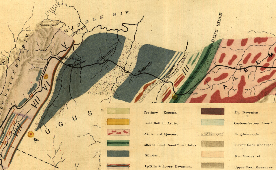
the Chesapeake and Ohio Railroad identified the different geologic formations along its route, including the Blue Ridge in 1872
Source: Library of Congress, Map showing the economic minerals along the route of the Chesapeake & Ohio Rail Way (Thomas S. Ridgway, 1872)
When the basalt flowed as the supercontinent Rodinia broke up, Virginia was not in its current location. The North American continent was located south of the Equator, and twisted 90 degrees clockwise from its present orientation. In the last 600 million years, the crustal plate including Virginia has drifted north and rotated counterclockwise by 90 degrees into its current position.4
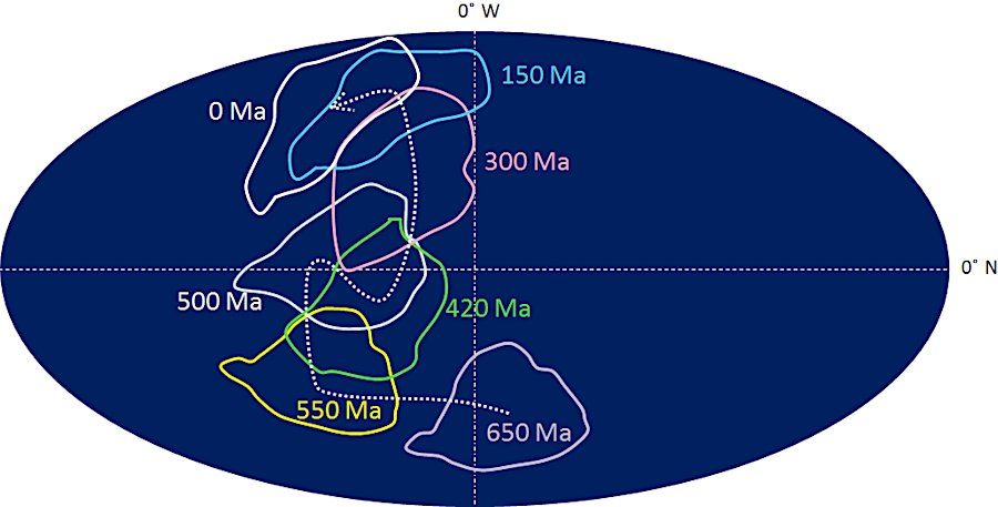
what is now the Catoctin Formation in the Blue Ridge flowed to the surface as lava when the tectonic plate was south of the Equator
Source: Physical Geology, Geological History of Canada (21.1)
After the basalt flows, the Iapetus Ocean continued to widen. The continental plates drifted apart during the Cambrian Period, and sediments washed from Virginia's surface down to the oceanfront shoreline. About 500 million years ago, those sediments formed beaches similar to Virginia Beach today on top of the basalt flows. Further offshore, rivers eroding the North American craton carried layer after layer of sediment into deeper waters, creating a continental shelf of silt, mud and quartz (silica) sand.
Initially, what today is the Blue Ridge of Virginia was located within the Iapetus Ocean near the edge of the North American tectonic plate. The basalt flows were close enough so large sand particles eroding off the land, transported by ancient rivers for which we have no names, settled on top of the lava. Today, the sand particles covering the Catoctin basalt flows is known as the Weverton Formation in Northern Virginia. In Tennessee and North Carolina, the same rock is called the Unicoi Formation
As the mountains eroded to a lower elevation, a different type of sediment was deposited. Perhaps the climate shifted and/or river channels shifted, and the old rivers had less energy and could no longer carry large sand particles the same distance offshore. Perhaps sea level rose, increasing the distance from the eroding tectonic North American plate, and heavy sand particles dropped out of suspension before reaching the old basalt flows.
For whatever reason, the rivers and ocean currents carried only small particles of silt and mud to bury the Weverton Formation. Instead of more sand deposits, silt-rich sediments known today as the Harpers Formation (or Hampton Formation in some areas) were deposited on top of the Weverton sandstone.
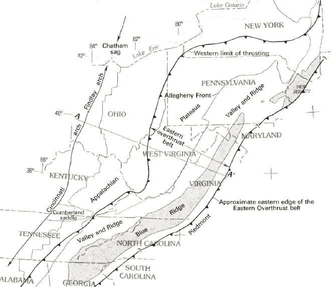
the Blue Ridge was thrust to the west when Africa collided with North America 250 million years ago
before being buried, then uplifted and exposed by erosion
Source: US Geological Survey Bulletin 1839-I, J, Middle Eocene Intrusive Igneous Rocks
of the Central Appalachian Valley and Ridge Province: Setting, Chemistry, and Implications for Crustal Structure
When rising sea level enabled the Iapetus Ocean to drown the shoreline of Virginia, barrier islands developed. They were comparable to modern barrier islands in the Atlantic Ocean at the Eastern Shore today. The ancient barrier islands ended up as the Antietam Formation, which known as the Erwin Formation in some areas.
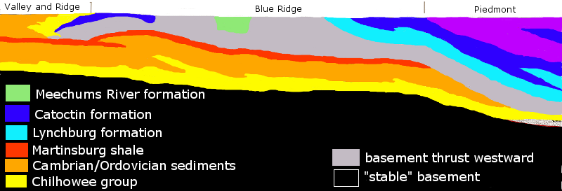
The sand-sized particles of the Antietam/Erwin Formation rest on top of the Harpers/Hampton Formation. The Antietam/Erwin Formation is the remainder of those barrier islands. The different sedimentary layers on top of the Catoctin lavas are known today as the Chilhowee Group. The Weverton Formation is the oldest. It is at the bottom of the Chilhowee Group, right above the Catoctin lava. The Harpers/Hampton Formation in the middle, and the Antietam/Erwin Formation is the youngest formation and at the top of the Chilhowee Group.
For whatever reason, the different continental plates which had split apart after Rodinia cracked up then reversed direction. Africa and North America started to move together again, and the Iapetus Ocean began to close.
A chunk of continental crust known as Avalonia moved closer to the shoreline of Virginia, and a "foreland basin" developed to the west of the continent's edge. That basin was a depression in the ocean floor between Avalonia and the edge of the North American plate,. In the salt water above that depression, zillions of tiny sea creatures with tiny shells of calcium carbonate lived and died. Their calcium carbonate coatings accumulated on he ocean floor in layers that compressed to form limestone.
As the Iapetus Ocean closed, "terranes" or island arcs such as Avalonia crunched into Virginia and the rest of eastern North America during the Taconic and Neo-Acadian orogenies. Finally, the tectonic plate with Africa pushed into the tectonic plate with North America. That collision eliminated the Iapetus Ocean, and the compression of the plates triggered the Alleghenian orogeny.
Those tectonic collisions and orogenies buried the Grenville basement, Catoctin lava flows on top of the basement, and the metamorphosed sediments and beaches on top of that. The burial was deep enough for heat and pressure to metamorphose the rocks known today as the Weverton/Unicoi, Harpers/Hampton, and Antietam/Erwin formations as well as the Catoctin lavas underneath.
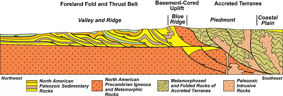
The collision of the African and North American tectonic plates pushed up the Ancestral Appalachian Mountains. The pressure also cracked the edge of the North American plate and shoved a slice westward. The pressure uplifted and thrust segments of the 1.1 billion year old Grenville bedrock miles to the west from roughly the location of modern I-95.
A tectonic event, the collision of the African and North American plates, cracked the basement. What today is the Blue Ridge is out of place, detached from the other basement rocks where it originally crystallized. The billion-year old Blue Ridge rocks, with layers of Swift Run formation, Catoctin greenstone, and the Weverton/Harpers/Antietam formations, were shoved westward bt the African Plate and have ended up on top of younger formations of limestone sediments deposited in the Iapetus Ocean.
As a result, billion-year old rock is now exposed in the core of the Blue Ridge at places such as Old Rag Mountain. The same basement rock is still buried underneath the Piedmont, Coastal Plain, and Outer Continental Shelf, where the collision with Africa metamorphosed the bedrock but left the basment intact.
the Blue Ridge is a slice broken off from the rest of the billion-year old basement bedrock, originally the roots of the Grenville Mountains
Source: National Park Service, Convergent Plate Boundaries—Collisional Mountain Ranges
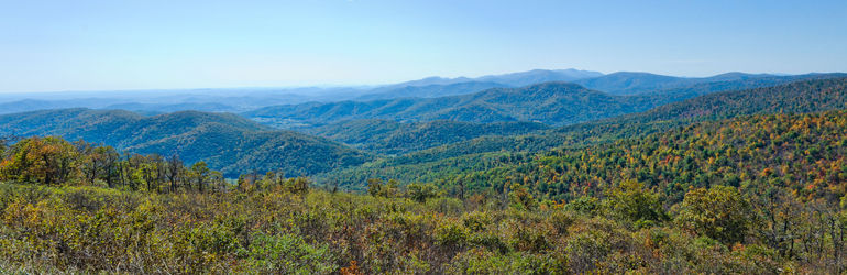
At the Blue Ridge the roots of the Grenville mountains, the Catoctin lava flows, and the Weverton/Harpers/Antietam formations sit on top of younger limestone formations. Rain and wind have carved a new series of ridges and valleys into the ancient rocks of the Blue Ridge. Differential erosion has again created a landscape with roughly 2,000 feet of topographic relief. Valleys within the Blue Ridge have been created where hard granitic bedrock wore away at different rates, with faster erosion where bedrock was cracked vs. where it remained more solid.
As the igneous bedrock of the Blue Ridge was pushed westward (in modern orientation) by the African Plate during the Alleghenian Orogeny, limestone formations that had accumulated in the edge of the Iapetus Ocean between the Cambrian and Mississippian periods were cracked. Some layers were shoved 60 miles westward, along with the Blue Ridge that was pushed up and westward. Where the limestone layers were cracked, some were "double stacked" on top of themselves or other formations. Stacking reduced the width of the Pulaski thrust sheet by 80%, while other thrust sheets on the western side of the Valley and Ridge province (further away from the pressure from the African Plate) were reduced in width by 10%-20%.
The Catoctin basalt itself would be pushed down six-ten miles, deep enough to be metamorphosed by heat/pressure that realigned atoms and created new minerals such as epidote. Epidote is a green mineral, and is so common in the metamorphosed basalt that the Catoctin formation in Shenandoah National Park is often referred to as "greenstone." The sediments on top of the basalt lava flows were also compressed and metamorphosed, converting sandstone into layers of quartzite. Thanks to cycles of deposition and erosion, the crystalline basement bedrock has moved up and down into the earth almost like an elevator.5
As part of the Alleghenian orogeny, when Africa collided with North America 300 million years ago and the supercontinent of Pangea formed, the edge of Virginia was cracked and pushed west. A slice of buried billion-year old granites, with metamorphosed sediments on top, was thrust 40-60 miles from its original position. As Africa pressed against North America, the younger carbonate bank and sandy beaches that had formed on the edge of the Iapetus Ocean (exposed today in the Shenandoah Valley) ended up being shoved underneath the older slice of "basement" that was lifted up and pushed inland.
It has been 250 million years since the collision with Africa cracked the Grenville basement bedrock and shoved a slice of the edge of Virginia to the west. Since then, Pangea has broken up, like the predecessor supercontinent Rodinia. The ocean formed when Africa and North America parted is known as the Atlantic Ocean, and 250 million years of erosion has exhumed the slice of "basement." That 1.1 billion year old basement bedrock, coated with 550-million year old lava, is exposed as the Blue Ridge today.
As Africa and North American collided, thrusting up a slice of old Grenville basement and lava, erosion immediately began to wear down the new Appalachian mountains. As Pangea split, the Atlantic Ocean began to form and what is now western Virginia was underwater.
Sediments were deposited within the ocean. Sand, silt and mud covered the Catoctin lava which was already on top of the 1.1 billion year old Grenville basement bedrock, plus the Weverton Formation, Harpers/Hampton Formation and Antietam/Erwin Formation.
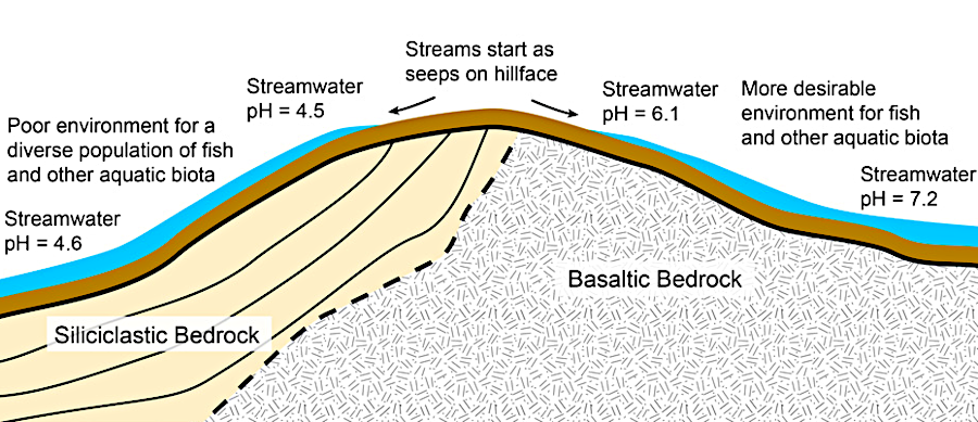
the Chilhowee Group creates more-acidic runoff on the western side of the Blue Ridge
Source: National Park Service, Geologic Diagram
Perhaps 20,000 feet of sediments accumulated, pushing the slice of basement deep under the surface. Heat and pressure metamorphosed the Catoctin lava; molecules within crystals realigned to create new minerals such a epidote. The color of epidote is the reason the metamorphose Catoctin lava is called "greenstone." The sandstone deposited on top metamorphosed into the quartzite of the Weverton/Unicoi Formation, and the sandstone from barrier islands metamorphosed into the Antietam/Erwin Formation. The mud and silt on top of the Weverton Formation metamorphosed into the schist, phyllite, and shale of the Harpers/Hampton Formation.
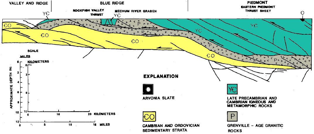
how Cambrian/Ordovician sediments (exposed in Shenandoah Valley) may lie underneath the Grenville-age rocks (exposed as the Blue Ridge)
Source: Virginia Department of Mines, Minerals and Energy, Virginia Minerals
Oil And Gas Exploration And Development In Virginia, 1979-1988 (February 1990)
Because the land was thrust to the west when the African and North American plates collided, the core of the Blue Ridge mountains within Shenandoah National Park (including Old Rag Mountain) was once located somewhere near I-95. The sediments of the Swift Run formation were more resistant to the deformation during thrusting and metamorphism than the Catoctin greenstone, the metamorphosed lava above the sedimentary layers.
The sediments ended up as deformed blobs called "boudins," the French word for sausage. Some were exposed when the Blue Ridge Tunnel was cut through the Blue Ridge near Waynesboro in the 1850s to reduce the elevation that trains had to climb.6
Source: College of William and Mary, Blue Ridge Tunnel Movie
Erosion since the formation of Pangea 270 million years ago has exposed the old slice of basement rock thrust westward by the collision with Africa. The Blue Ridge was exposed gradually as softer rocks around it eroded away faster, at a rate averaging 5.4–49 meters per million years.
Uplift, thrusting, and then differential erosion has created the Blue Ridge as a feature in the modern topography of Virginia. Topographic relief is distinctive because the hard granite/gneiss and metamorphosed basalt (Catoctin greenstone) has been slower to erode than the rock formations to the east and west.
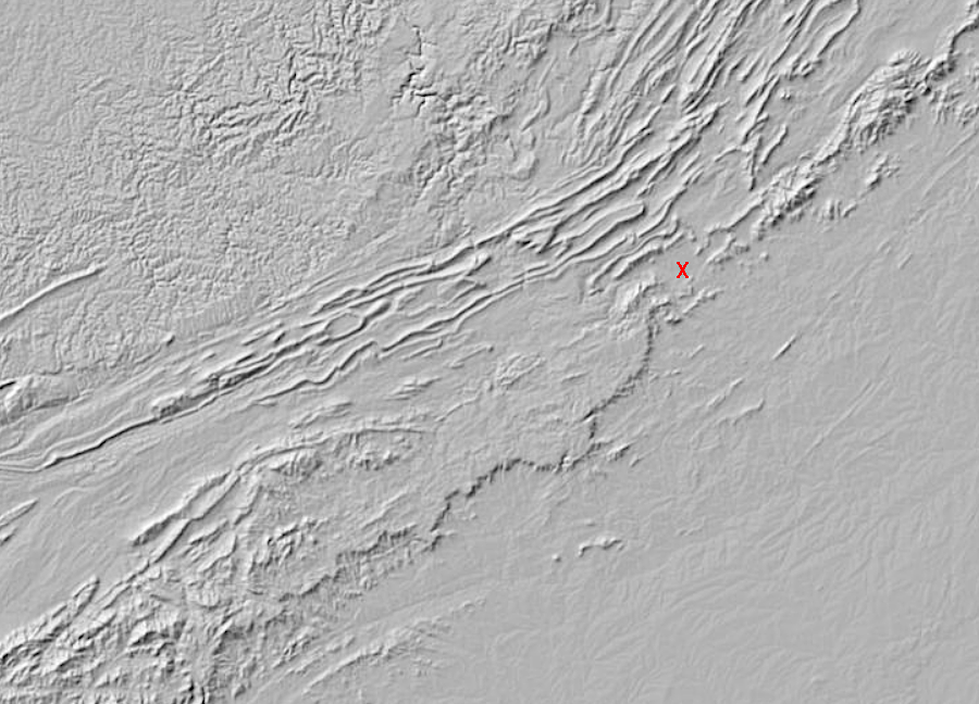
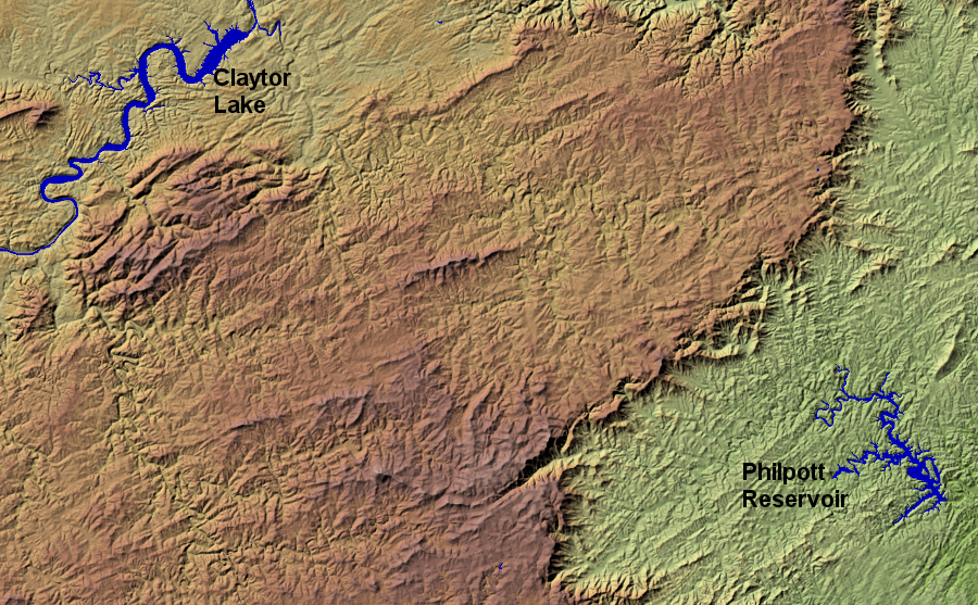
the Blue Ridge is narrow north of Roanoke (red X), but widens out to the south
Source: US Geological Survey, National Map
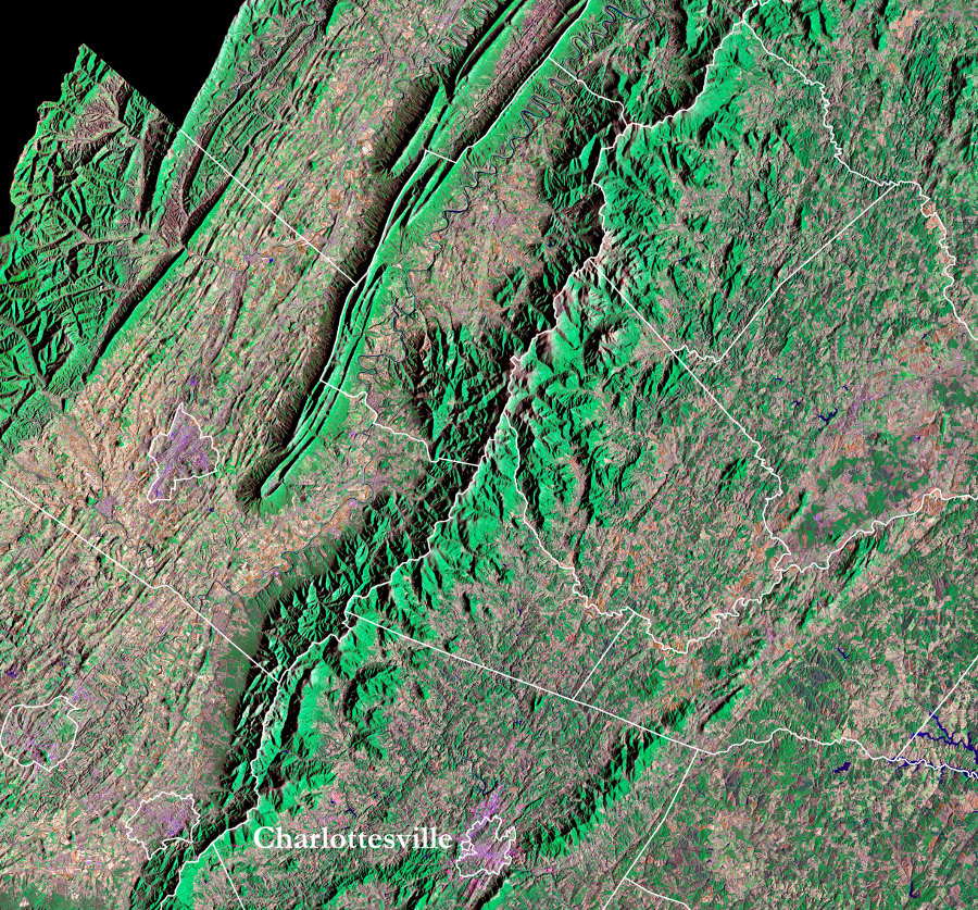
To the west of the Blue Ridge, erosion of softer Cambrian and Ordovician limestones in the Valley and Ridge physiographic province has formed the Shenandoah Valley, New River Valley, and other valleys which are sometimes lumped together as the "Valley of Virginia."
East of the Blue Ridge, the geologic formations in the Western Piedmont terrane also have eroded faster than the harder and older igneous bedrock of the Blue Ridge. The result: a ridge with 1,000-3,000 feet of topographic relief, with a valley to the west and a gently sloping plain to the east.
The Blue Ridge Escarpment with the topographic relief on the eastern side has survived since it was first exposed after the breakup of Pangea. Rivers draining to the Atlantic Ocean are etching away at both the Piedmont and Blue Ridge bedrock. In North Carolina's Pee Dee river drainage, the escarpment is migrating westward at 45 meters/million years.
The Roanoke River probably cut through the Blue Ridge and captured what is now the South Fork of the Roanoke River in the last 12.5 million years. The James and Potomac rivers also cut through the Blue Ridge and captured streams flowing on the west side in the last 5-10 million years. Drainage eastward to the Atlantic Ocean accelerated erosion in the limestone formations west of the Blue Ridge, creating relatively wide valleys in the Valley and Ridge physiographic province.
Stream capture sped up erosion of the Grenville-age rocks on the west side of the Blue Ridge. North of Roanoke today, the Blue Ridge is narrow because much of the igneous plateau has been washed downstream to eastern edge of North America. The North Fork and the South Fork of the Roanoke River are likely to etch away the bedrock and narrow the plateau in their watershed.
As their headwaters continue to erode, either the Roanoke River or the James River could end up capturing the New River. The New River currently flows at 1700 feet in elevation near Radford, while the Roanoke River is around 900 feet in elevation at the City of Roanoke. If the flow of the New River was diverted to the Atlantic Ocean, the shorter distance would increase the energy for erosion and narrow the Blue Ridge plateau even faster.7
old Blue Ridge crystalline basement/volcanics thrust over Cambrian/Ordovician carbonates/shale (now exposed in Shenandoah Valley)
Source: Virginia Department of Mines, Minerals and Energy, Publication 066: Part 1:
Interpretive seismic profile along Interstate I-64 in central Virginia from the Valley and Ridge to the Coastal Plain
the General Assembly used the watershed divide at the crest of the Blue Ridge to define county boundaries
Source: Earth Resources Observation and Science (EROS) Center, US Geological Survey (USGS),
Landsat State Mosaics
unravelling the story of Virginia's geology requires understanding the whole story of eastern North America
Source: US Geological Survey (USGS) and Geologic Society of America (GSA), Geologic Map of North America - South
erosion has carved a steeper escarpment on the eastern edge of the Blue Ridge in southern Virginia
Source: USGS National Elevation Dataset, NED Shaded Relief - Virginia