Triassic basins were formed when Pangea split up, Africa and North America moved apart, and the Atlantic Ocean formed
Source: Ron Blakely, "Paleogeography and Geologic Evolution of North America," Middle Triassic (230 million years ago)
Triassic basins were formed when Pangea split up, Africa and North America moved apart, and the Atlantic Ocean formed
Source: Ron Blakely, "Paleogeography and Geologic Evolution of North America," Middle Triassic (230 million years ago)
About 250 million years ago, after the supercontinent of Pangea formed, Virginia was located in the middle of that supercontinent. The diversity of life had been dramatically reduced by the massive extinction event at the end of the Permian Period.
In the Permian, immense lava flows from fissures in Siberia moved massive amounts of carbon dioxide into the atmosphere. Acid rain moved the CO2 back to the surface. The chemistry of the oceans changed, perhaps in part because plates of continental crust blocked currents and oxygen levels declined significantly. Sulfate particles in the atmosphere reduced the amount of sunlight reaching the surface.
In the "Great Dying" that marked the end of the Permian Period. Recovery was slow because a rare biogeochemical cycle kept the atmosphere warm and the oceans acidic. The extinction of radiolarians, a common marine organism which uses silica to create microscopic shells, led to the deposition of new clays on the ocean floor. Formation of the silica-rich clays released carbon dioxide (CO2).
The result was "reverse weathering" which offset the CO2 being sequestered as calcium carbonate (CaCO3) was deposited as limestone. Today, radiolarians extract almost all of the silica which flows into the ocean as rocks weather, so the formation of limestone is mitigating the increase of CO2 from the burning of fossil fuels.
The change at the end of the Permian was too fast for the different forms of life to adapt. Within just 100,000 years, 95% of species in the oceans died out. On land, 70% of the terrestrial species died. Nearly all the trees disappeared, creating a spike in fungi biomass as they decomposed the rotting biomass of the victims. The change in the fossil record resulting from that extraordinary extinction event is the basis for geologists making a distinction between the Permian and Triassic periods.
The Triassic Period began with global warming, triggered by the greenhouse gas effects of the high carbon dioxide levels. Carbon dioxide levels were six times greater than those of today, reaching 2,500 parts per million. Pangea stretched from the North Pole to the South Pole. There were no ice caps, in part because no land mass blocked currents in the Panthalassa Ocean which carried heat from the equator to the poles. Mega-monsoons swept across Pangea, bringing rain inland from wet coastal areas and creating extreme differences between the seasons.
The extinction of so many species, and the creation of a wide range of wet and dry habitats on Pangea, created unoccupied niches. New forms of life evolved to replace the species that died out in the Permian extinction.
Dinosaurs started as a small component of the new, revitalizing life on earth during the Triassic Period. Dinosaurs developed about 20 million years after the start of the Triassic Period, and they shared the earth with numerous other forms of life:1
evidence of dinosaurs is found in Triassic, Jurassic, and Cretaceous sediments
Source: Virginia Energy, Virginia Dinosaurs
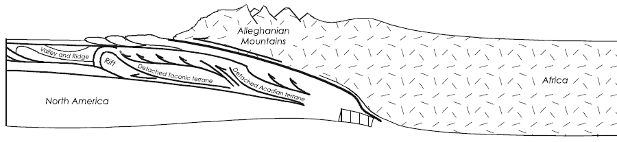
After the collision of the North American and African plates, Virginia ended up in the middle of Pangea. Island arcs similar to Japan, Indonesia, or the Aleutian Islands today had been smushed against the Virginia coastline on the Iapetus Ocean. The additions of those island arcs ("terranes") expanded the crust of Virginia, until the collision with the African plate. At the end of the Alleghenian Orogeny, the collision had pushed up the Ancestral Appalachians far from any ocean.
Africa made Virginia smaller, initially. The African Plate compressed the sediments of the continental shelf on the North American Plate, converting the Iapetus Ocean beaches of Virginia into hard crystalline rocks. Today, those old sediments are part of the Piedmont "basement" rocks. They are exposed clearly at Great Falls on the Potomac River, and today fill the space between the Blue Ridge and the Fall Line south to the North Carolina border.
During the Alleghenian orogeny, the African plate kept pushing against the North American Plate for millions of years. Virginia was caught in the middle, and the bedrock on the eastern edge of Virginia cracked under the pressure. Mountains as high as 20,000 feet were pushed up, comparable to how the modern Alps and the plateau of Tibet are being created as India crashes into the Asian tectonic plate.
The limestone layers of North Mountain, west of Staunton, were broken into slabs and pushed over 35 miles west. Other slabs of eastern Virginia were thrust westward perhaps 40-60 miles.2
About 250 million years ago at the start of the Triassic Period, the rocks of modern-day Shenandoah National Park were once located roughly where I-95 is today. The collision with Africa, the Alleghenian orogeny, had shoved the Blue Ridge miles to the west.
Rocks now exposed in the Shenandoah Valley and the rest of the Valley and Ridge Province were folded, crumpled, broken, and thrust on top of each other. In southwestern Virginia, Pine Mountain was also thrust westward 4-11 miles.3
The great squeezing by the continental collisions cracked layers of bedrock, pushed them towards the center of the North American Plate, and stacked layers on top of each other. The Alleghenian orogeny just before the start of the Triassic Period narrowed the width of Virginia by as much as 200 miles.4
Late Paleozoic, when Virginia was located in middle of Pangea and ancestral Allegheny Mountains may have been 20-25,000 feet high
Source: USGS Circular 1264, "Regional Tectonic History of Northern Virginia" in Geology of the National Capital Region - Field Trip Guidebook
During the formation of the supercontinent of Pangea, all the continental crust clumped together. The resulting wide crustal plate began to trap the heat rising up from the mantle and became unstable.
Pressure from the trapped heat and changing flow patterns of molten rock in the mantle began to pull Pangea apart, just as Rodinia had cracked up earlier. No supercontinent lasts forever; crustal plates move in cycles, and supercontinents break apart into smaller components.
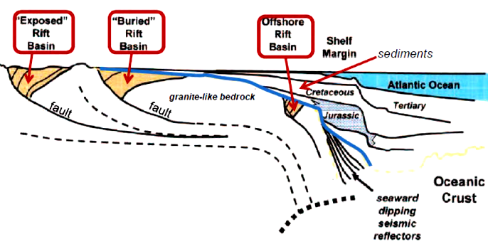
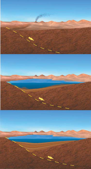
As the African, North American, and other plates pulled apart, the crust in the middle of Pangea stretched. Earthquakes were common in what is now Virginia. As the land spread out, the crust thinned. Rift valleys known as Triassic Basins were created, creating a landscape similar to the Basin and Range in Nevada today.
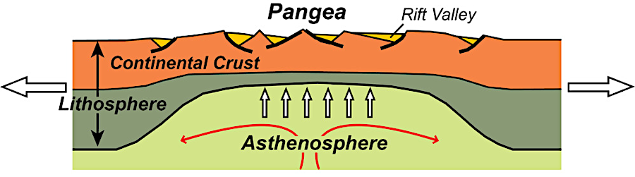
Pangea trapped heat from the mantle and ultimately split apart, creating Triassic Basins and ultimately the Atlantic Ocean about 180 million years ago
Source: National Park Service, Continental Rift Diagram
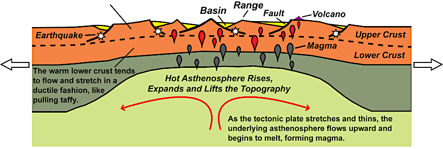
the crust in Nevada today is being stretched, resulting in rift valleys comparable to the Triassic Basins formed as Pangea cracked up
Source: National Park Service, Continental Rift: Topography, Earthquakes and Volcanism
Basins formed and sank, with sediments tilting down to the faults on the western edge. Rivers, lakes and wetlands formed in closed basins with no river outlets, similar to the Great Salt Lake today. Sand layers were deposited as braided streams switch channels after major storms.
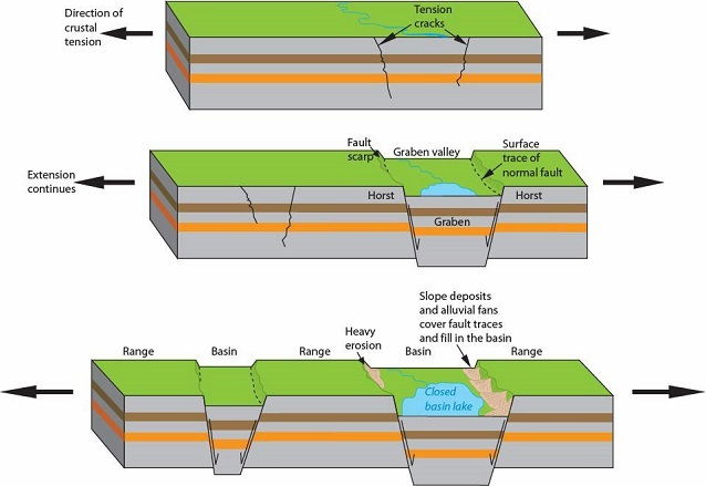
Triassic Basins formed as rift valleys with lakes, when Panga's crust pulled apart
Source: National Park Service, Horst and Graben
Other sedimentary layers indicate an arid environment. The sides of the basin may have looked like a modern desert, while the floodplains of small sinuous rivers in the deepest part of the basin may have been vegetated like a modern jungle. A modern analogue could be the Barwon River in New South Wales, Australia.
Erosion ultimately deposited up to 20,000-25,000 feet of sand and silt into the basin.5
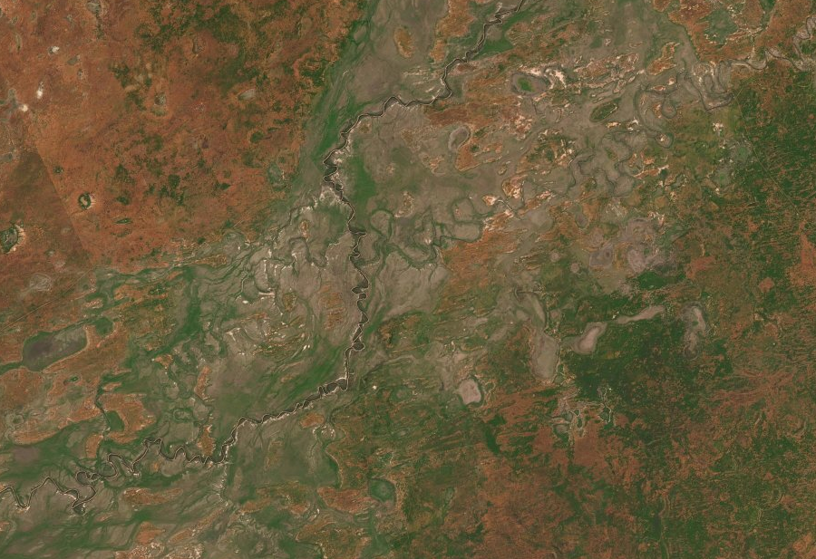
the Triassic basins may have been a mixture of dry and wet environments, similar to the Barwon River in New South Wales today
Source: ESRI, ArcGIS Online
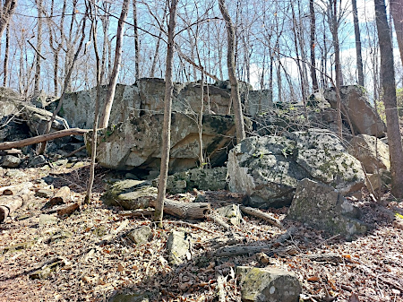
The sandstones created from those sediments are known as "redbeds" due to the oxidized iron or rust that coats the sand grains. The grains in the sandstone bedrock were cemented together more tightly than the Aquia Sandstone on the Coastal Plain.
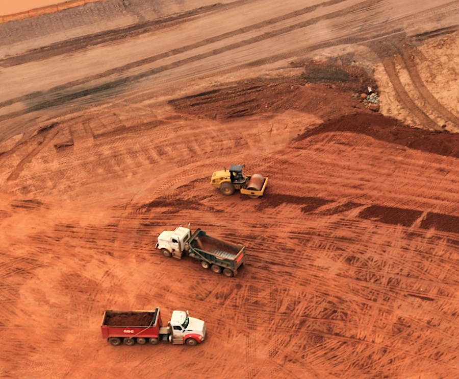
construction of a new data center near Manassas airport reveals the red subsoil in the Triassic Basin
Source: Historic Prince William, Aerial Photo Survey 2019
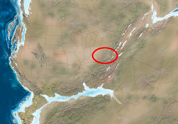
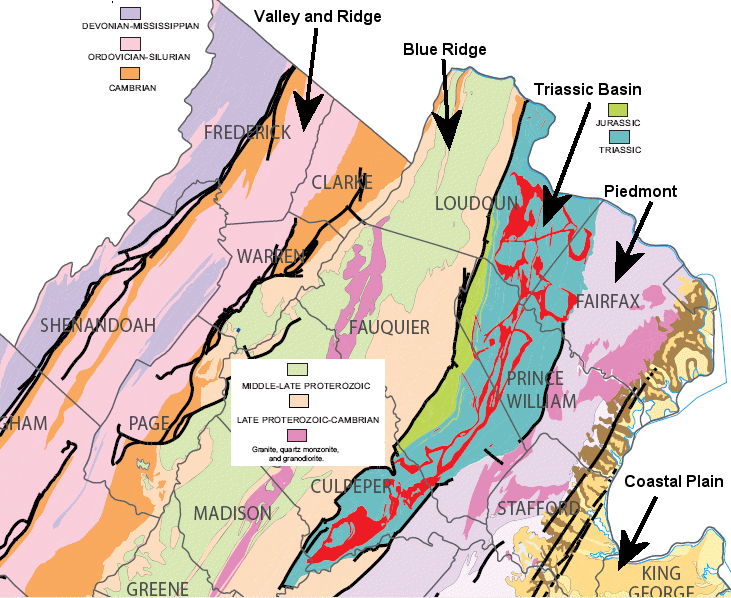
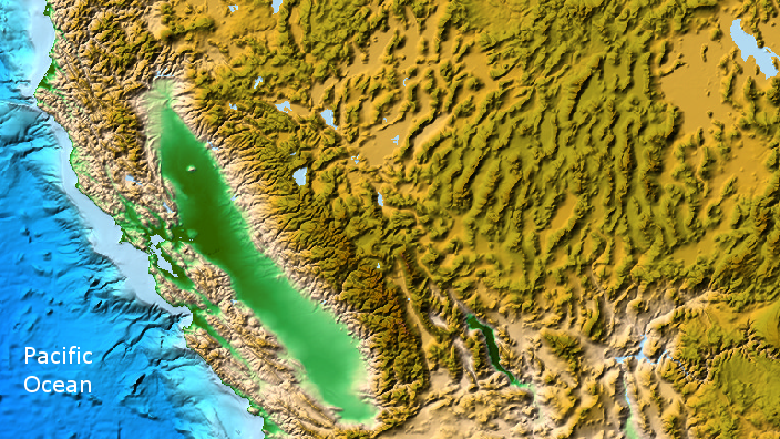
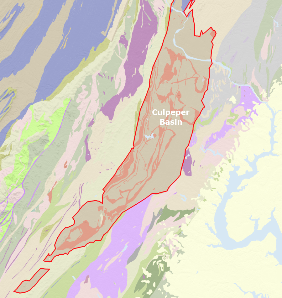
In Northern Virginia, drivers headed west on I-66/Route 29 may notice the Culpeper Basin west of Centreville. The valley stretches to the Bull Run Mountains, where the interstate highway goes through Thoroughfare Gap, on its way to the Shenandoah Valley.
The drop in elevation west of Centreville reflects differences in the bedrock. Differential erosion has, for the moment, excavated a shallow valley in which Leesburg, Manassas, and Culpeper are located.
The sediments in the Triassic Basin west of Centreville are eroding faster than the metamorphic bedrock of the Piedmont formations to the east, between I-95 and Centreville). The Triassic Basin is also eroding faster than the metamorphic/volcanic formations of the Blue Ridge to the west.
the Culpeper Basin is a Triassic Basin east of the Blue Ridge in Northern Virginia
Source: Virginia Energy, Geology Mineral Resources
As the sediments filled in the basins, dinosaurs were walking on the land and shallow lakes. Connecticut established Dinosaur State Park to protect an extraordinary set of tracks discovered in the 1960's by an alert bulldozer operator, who was preparing a site for a state office building. Some dinosaur tracks were fossilized in rocks that today are excavated at construction sites and in quarries in Loudoun, Prince William and Culpeper counties.6
The reddish/purple sandstones from Triassic basins oxidized after quarrying to become the "brownstones" used in many of the buildings in Brooklyn, plus in the Smithsonian "castle" on the National Mall in Washington DC and the Stone House at Manassas National Battlefield Park.
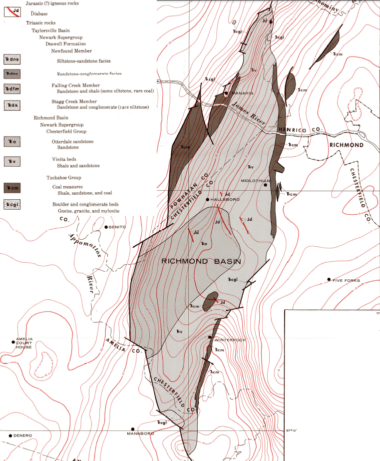
In addition, some harder rocks formed in the basins. In some places where the crust thinned, molten magma rose from the mantle up into the Triassic basin sediments to the surface and cooled into igneous rocks known as basalt. Where the rock cooled slower and larger crystals formed, the volcanic rock is known as diabase.
red lines show volcanic sills and dikes
Source: Virginia Department of Mines, Minerals and Energy (DMME) Geologic Map of Virginia
Triassic basins formed as Africa pulled away from North America, the crust thinned - and in places, the crust broke
Source: King George County, Taylorsville Basin Community Meeting - June 12, 2014, King George County Fracking 101
Basins formed at cracks where the land dropped, from Connecticut to Alabama, during the Triassic and Jurassic periods in the Mesozoic Era. Volcanic magma rose where the crust thinned and broke to create sills, dikes, and lava flows on the surface. Because the breakup of Pangea triggered formation of the basins starting in the Triassic Period, the depressions are called Triassic basins even if they continued to expand and lava continued to rise during the Jurassic Period.
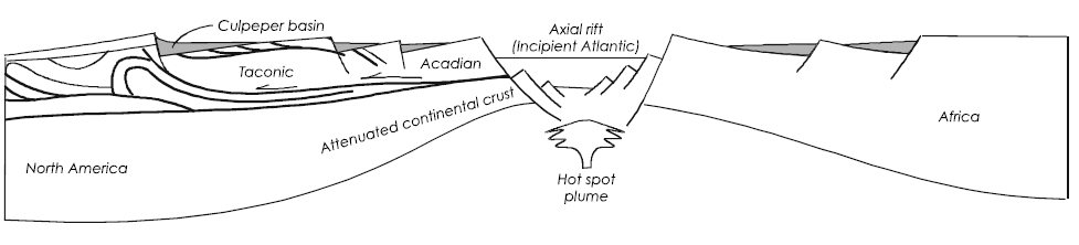
Pangea cracked at the end of the Triassic Period. Lava oozed out in eruptions of "flood basalts" on the surface. The volcanism was short and intense, concentrated in just 600,000-5 million years.7
The Central Atlantic Magmatic Province (CAMP) was one of the largest flood basalts in the history of the earth. Lava flowed over what is now the edge of Eastern North America, Brazil, and Northwestern Africa. Massive amounts of rock were extruded, bringing to the surface rock that may have been pushed deep by subduction in the Acadian/Avalon orogeny.
That crust melted at depth, then moved up and flowed onto the surface of the earth. The carbon dioxide released during the flood basalt eruptions was a factor in the extinctions that define the end of the Triassic Period and the start of the Jurassic Period.8
Ultimately, a "spreading ridge" developed, oozing magma with the chemical composition of Mid-Ocean Ridge Basalt. The Atlantic Ocean was born, expanding into its current configuration over the last 200 million years.
Triassic to Early Jurassic periods - when Pangea split up, Atlantic Ocean formed, and Culpeper Basin filled with sediments
Source: USGS Circular 1264, "Regional Tectonic History of Northern Virginia" in Geology of the National Capital Region - Field Trip Guidebook
when Pangea split up, the crust cracked and basins filled with sediment - except for the one which filled with seawater and became the Atlantic Ocean
Source: US Geological Survey Birth of the Mountains
Steven Spielberg highlighted the Jurassic Period when he titled his movie "Jurassic Park" because that was the period in which dinosaurs evolved further to dominate the land masses. The moviemaker took artistic license with the geologic time scale; Tyrannosaurus rex evolved only near the end of the Cretaceous Period.
The landscape of Virginia in the Mesozoic Era, during the Triassic/Jurassic Periods, may have looked like the Basin and Range province in Utah/Nevada or the Red Sea today. Arabia and Africa starting to split apart 25 million years ago. Today, East Africa has basins formed by blocks of crust dropping down, comparable to the Triassic Basins of Virginia.9
 Basin and Range Province (Central Valley of California on left, Great Salt Lake in upper right-hand corner), where continental crust is stretching east-west and "mountain ranges look like rows of caterpillars marching northward"7 Source: NOAA National Geophysical Data Center, Natural Hazards Viewer |
 Red Sea, where a new ocean is forming as continental plates split apart Source: NASA Goddard Earth Sciences Data and Information Services Center, Science Focus: Ethiopia, Red Sea, and Nile River |
The first lava flows reached the surface in what is now Morocco, then Brazil and North America. There were four distinct waves of rising lava over just 600,000 years as the crustal plates shifted. Along with the lava came carbon dioxide. The greenhouse gas led to warmer oceans, melting ice crystals (clathrates) that had trapped methane. Average temperatures climbed 3-4 degrees Celsius (5-7 degrees Fahrenheit) and the ocean grew more acid, interfering with production of limestone shells of invertebrates and plankton.
Species unable to cope died and food webs collapsed. For reasons still not clear, dinosaurs were able to survive better than their rival archosaurs. The Permian extinction led to the rise of dinosaurs. Just 20% of the footprints in the Triassic sediments were from dinosaurs before the four waves of eruptions, but afterwards 50% were from dinosaur species.10
Late Cretaceous to Early Cenozoic, when some Triassic basins were buried under younger sediments on the Coastal Plain
Source: USGS Circular 1264, "Regional Tectonic History of Northern Virginia" in Geology of the National Capital Region - Field Trip Guidebook
Where magma cut through the sedimentary layers, it formed "dikes" of near-vertical pipes of igneous rock surrounded by flat-lying sediments. Where the magma squeezed between flat layers of sediments, it shoved some sandstone/shale layers upwards slightly before the igneous rock cooled into "sills" of diabase rock.
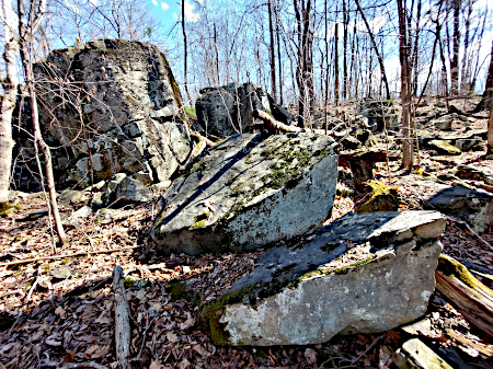
once-buried basalt is exposed at Conway Robinson State Forest
Sills cooled before reaching all the way to the surface, but may be exposed later through erosion or excavation. Today, the slower-to-erode igneous rock has created ridges within the Triassic basins, including the ridge to the west of Route 28 between Dulles International Airport-Route 7. The famous Cemetery Ridge and Little Round Top at Gettysburg battlefield in Pennsylvania were also created by differential erosion of the igneous vs. sedimentary bedrock.11
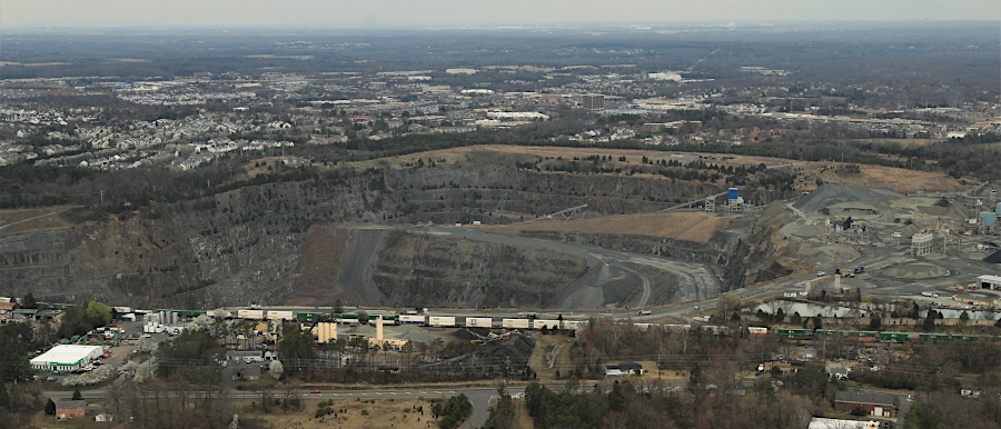
Vulcan quarry behind Stonewall Jackson High School in Prince William County
Source: Historic Prince William, Aerial Photo Survey 2019
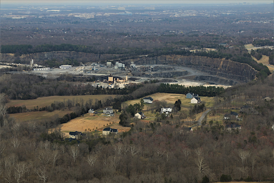
Luck Quarry east of Stone Bridge over Bull Run, in Fairfax County
Source: Historic Prince William, Aerial Photo Survey 2019
Today, quarries excavate the hard diabase located in dikes and sills and crush the igneous rock for use in asphalt, concrete, and building foundations. Diabase is essential for construction of roads and buildings in Northern Virginia. The distance between quarries and building sites is a major factor in the cost of construction. The cost of transporting dump trucks loaded with aggregate for foundations, concrete, and asphalt can exceed the value of the rock in the truck.12
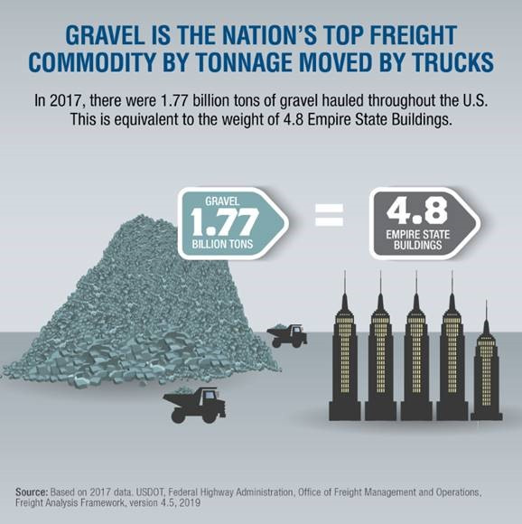
the high cost of transporting rock to a construction site increases the value of quarries near urban areas
Source: Federal Highway Administration, Tons of Gravel Infographic
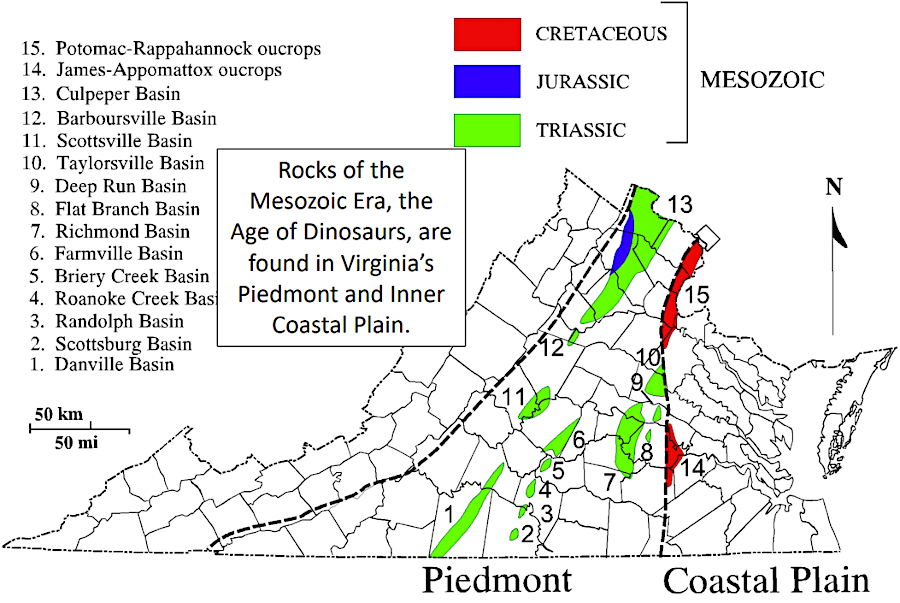
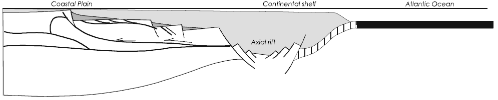
As Pangea broke up, the crust stretched, thinned, and cracked in places. In the Culpeper basin, the crack formed at the eastern edge of the Blue Ridge. The land there dropped down, creating multiple Triassic basins which slowly accumulated sediments as nearby highlands eroded. Some of those basins are underneath the Continental Shelf now, covered by waters of the Atlantic Ocean. Other basins are in the Piedmont, such as the Taylorsville basin north of Fredericksburg and the Danville basin south of the James River.
West of the Blue Ridge, the stretching crust created narrow dikes filled with igneous rock rather than wide basins filled with sediments. Typically, metallic minerals are found in the igneous and metamorphic bedrock. Most mining in Triassic basins is for sand and gravel.
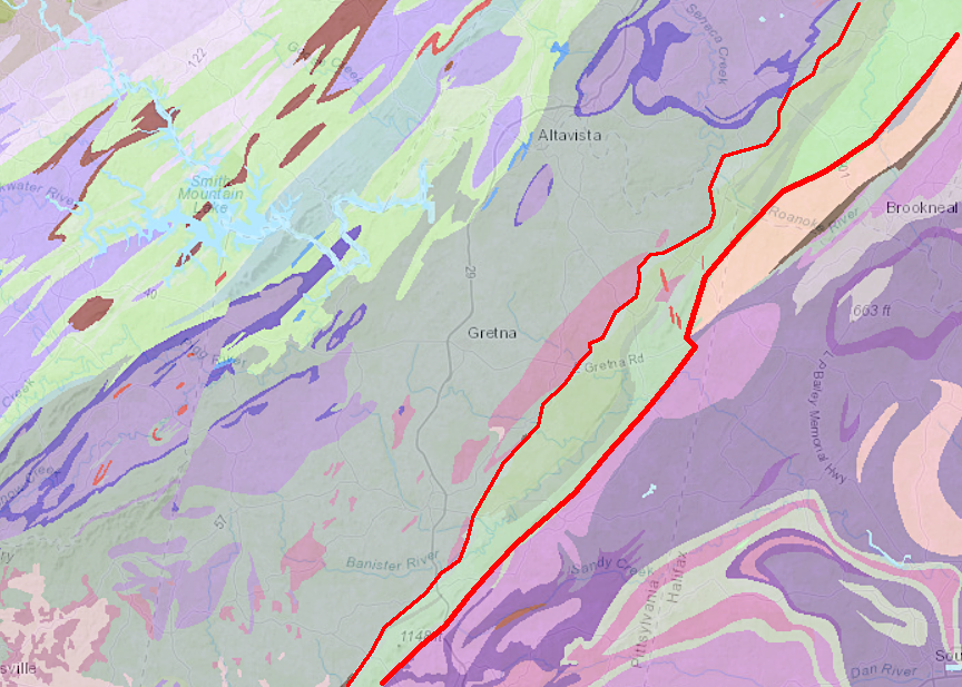
in Pittsylvania County, mining for iron, copper, zinc and other metals is primarily east and west of the Triassic Basin (within red lines)
Source: Virginia Department of Energy, Mineral Mining
In the Triassic basins, layers of sediments tilted as basins dropped down at the faults on their edges. In the Culpeper basin, the deepest part is on the western edge, next to the Bull Run Mountains and other parts of the Blue Ridge. On the eastern edge, sedimentary deposits are thin next to the now-exposed Piedmont rocks. Underneath the Triassic basins are the Piedmont bedrock, buried at different depths:13
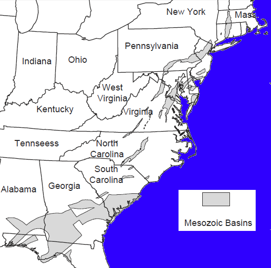
Triassic/Jurassic basins in the eastern United States, formed as the crust cracked
during the separation of Africa and North American tectonic plates
Source: US Geological Survey (USGS), Geology and Energy Resources of the Triassic Basins of Northern Virginia: Old mines and geology of the Richmond Basin
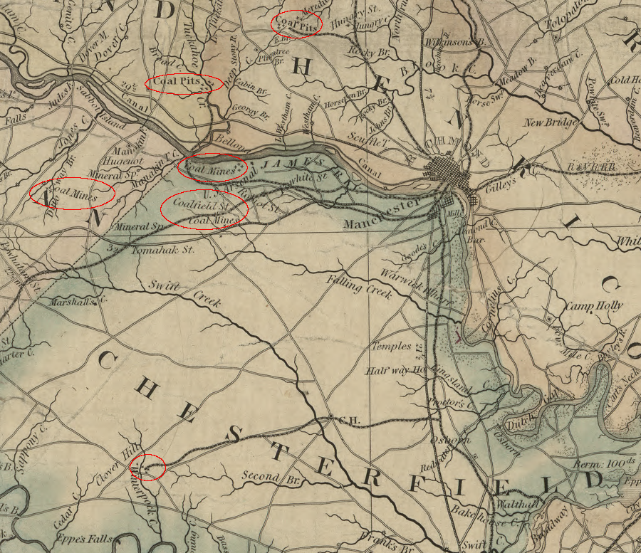
Lakes formed at the bottom of the basins and then dried up. Swamps in the Richmond basin lasted long enough to accumulate enough organic material to form commercially valuable coal deposits. The availability of coal was identified there by 1701. The first large coal mines in Virginia opened in the Midlothian coal fields south of Richmond in the 1730's, with the state's first railroad to haul it to the James River at Manchester.
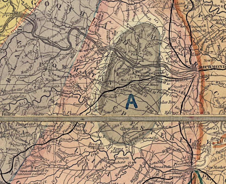
the Richmond coal fields ("A" on map) were formed in a Triassic basin
Source: Library of Congress, Geological map of the state of Virginia (Thomas S. Risgeway, 1862)
Before the Civil War, coal was also mined in Prince Edward County within the Farmville Basin.14
Virginia's first coal mines, developed by the 1730's, were in the Richmond Basin
Source: Virginia Department of Mines, Minerals, and Energy, Simple Bouguer gravity anomaly map of the Richmond and Taylorsville basins and vicinity, Virginia (Publication 053)
The Triassic sediments trapped organic material which has decayed and converted into natural gas. The Taylorsville Basin, stretching northeast of Bowling Green to beyond the Potomac River, has been a particular target for drilling for natural gas. What were previously uneconomic resources in thin "pay zones" of buried Triassic Period sediments became more valuable after the 1990, with development of directional drilling and fracking technology. By 2015, 80,000 acres had been leased by a Dallas-based company for potential natural gas extraction in King George, Westmoreland, Caroline, Essex and King and Queen counties.
However, in 2020 the General Assembly banned fracking east of I-95 in an area designated as a Ground Water Management Area. That blocked drilling in the Virginia portion of the Taylorsville Basin.15
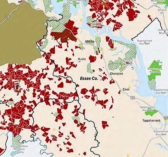
much of the Taylorsville Basin in Essex County was leased for potential natural gas extraction
Source: Essex County, Comprehensive Plan Approved July 14, 2015 (p.22)
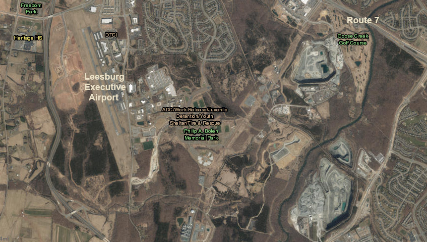
quarries near Leesburg Executive Airport excavate basalt from the Triassic Basin
Source: ESRI, ArcGIS Online
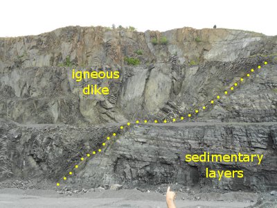 contact between vertical igneous dike and horizontal sediments at Bull Run Quarry (Fairfax County) |
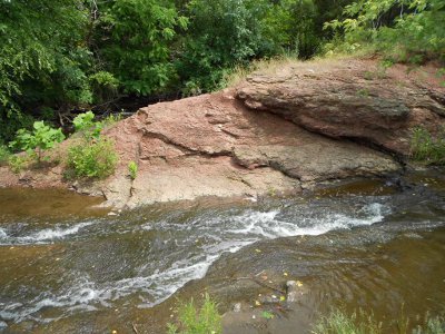 outcrop of Triassic shale/sandstone sediments in Horsepen Run at Dulles airport |
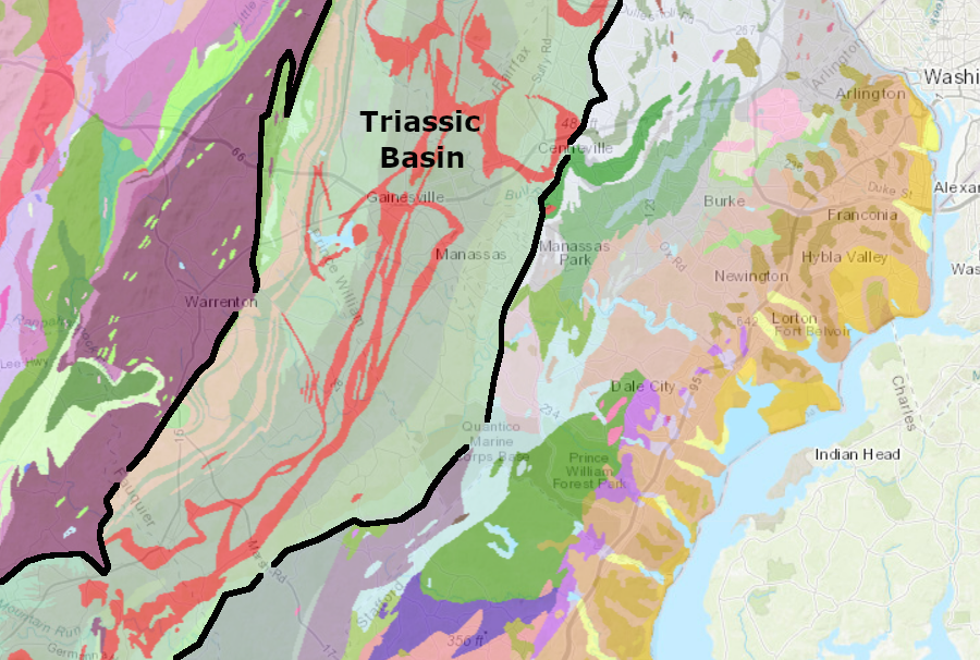
exposed basalt dikes (red) are common in the Culpeper Basin
Source: US Geological Survey, Geologic maps of US states
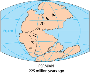
Virginia located in the center of Pangea (near the "G"), before the breakup
Source: USGS, This Dynamic Earth: The Story of Plate Tectonics
as Africa and North America pulled apart during the Triassic Period, cracks in the crust created low basins in which swamps and bituminous coal formed near the future site of Richmond
Source: Library of Congress, A map of the state of Virginia, constructed in conformity to law from the late surveys authorized by the legislature and other original and authentic documents (1859)
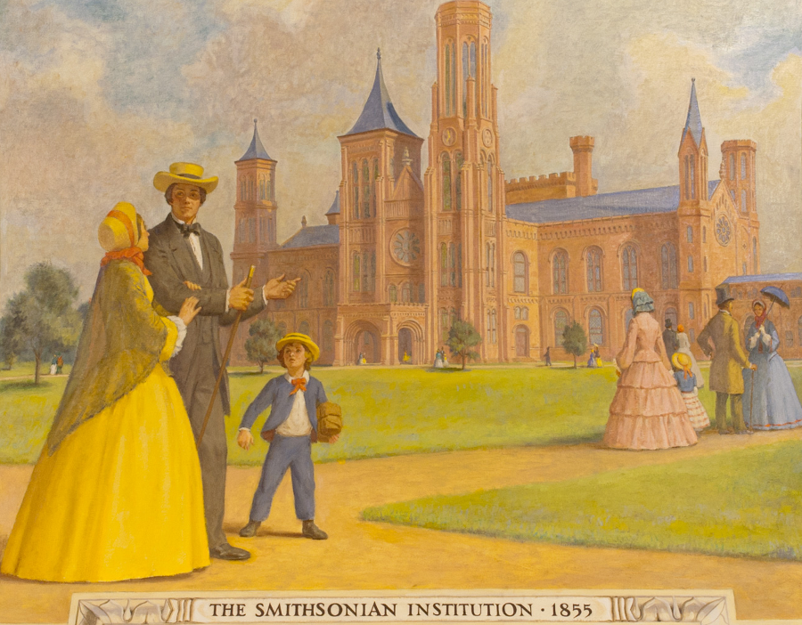
the Smithsonian "castle," the Stone Bridge at Manassas Battlefield, and the brownstone houses in Brooklyn are built from Triassic Basin sandstones
Source: Architect of the Capitol, The Smithsonian Institution, 1855