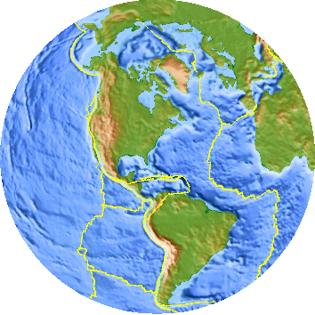
North American Plate
Source: US Geological Survey (USGS) World Plate Boundaries Animation
North American Plate
Source: US Geological Survey (USGS) World Plate Boundaries Animation
Virginia and the eastern side of the North American continent are in the middle of a tectonic plate. The North American Plate is one of the 15 or so major "chunks" of crust that float on top of the hot mantle. The plate includes both continental crust and heavier (iron- and magnesium-rich) oceanic crust.
The eastern coast of the United States marks the boundary between continental and oceanic crust, but the North American Plate includes both continental and oceanic crust. The Eastern Shore/Virginia Beach are at the edge of the continent, but are not located at the edge of the continental plate.
The eastern edge of the North American Plate is located in the middle of the Atlantic Ocean at the Mid-Atlantic Ridge. At that ridge, magma rises slowly and pushes Virginia (and the rest of the North American Plate) towards China, at the rate of about 2-3 centimeters/year or about 14 miles every million years.1
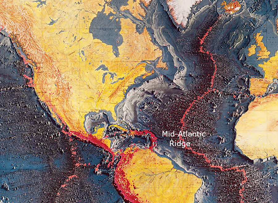
the Mid-Atlantic Ridge marks the eastern edge of the North American Plate
Source: Library of Congress, Seismicity of the earth, 1960-1980
Virginia is located far from the edge of the North American Plate. In contrast, California/Oregon/Washington are at the edge of the North American Plate. In Southern California, the western edge of the North American Plate rubs against the eastern edge of the Pacific Plate. That boundary is marked by the San Andreas Fault and many other named/unnamed faults.
The North American and Pacific plates are moving in different directions, and the rocks bend under the strain - up to a point. Earthquakes occur when the pressure to move exceeds the capacity of the rocks to resist motion. Intermittently, the North American/Pacific plates break free of each other, and the edges spring into a new alignment. As the land moves into the new alignment, everything shakes nearby in the earthquake - and buildings, highway bridges, etc. may collapse.
Since Virginia is in the relatively-stable inner portion of a plate, Virginia does not experience the large-magnitude earthquakes that affect Los Angeles, Alaska, Haiti, Japan, Chile, or other places that are on a tectonic plate's edge. As noted by the Virginia Department of Energy:2
The tectonic stresses in the North American plate are caused by motion to the west and twisting of the tectonic plates, but also by isostatic rebound. Melting of the massive ice sheet that reached into Pennsylvania 18,000 years ago removed a weight on the crust; land underneath the former ice sheet is rising up. At the same time, the bulge that once uplifted the surface east of the edge of heavy ice sheet is dropping back down now. As the bulge drops, the Chesapeake Bay drops. Sea level rise is magnified by the sinking crust, and the vertical shifts of the land mass create stresses that can trigger earthquakes.
Vertical shifts may extend much deeper than the depression/rebound triggered by the ice sheets. Subduction of oceanic crust beneath continental plates may continue long after the evidence of an orogeny has eroded away.
The Taconic and Neo-Acadian orogenies, or the collision of the African and North American plates 250 million years ago, may have left behind chunks of crust that are still sliding down to the mantle. The crystals in such crustal fragments will realign into different minerals as heat and pressure increases, while the crystals in mantle minerals may also realign as the cooler crustal fragment slides by. The realignments could generate stress that propagates to the surface and is released through an earthquake.
In addition, erosion of the crust redistributes weight as mountains get lower and sedimentary layers get higher. Vertical and horizontal changes in the weight of the crust creates additional isostatic stress:3
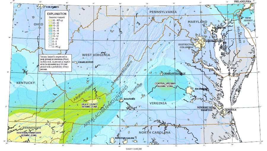
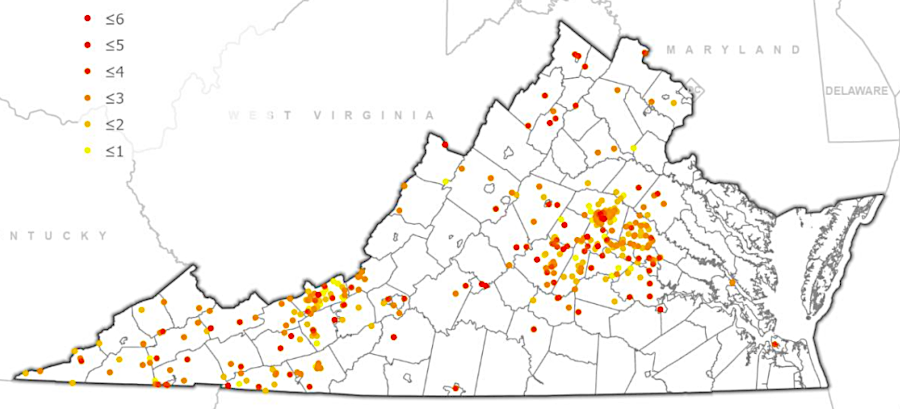
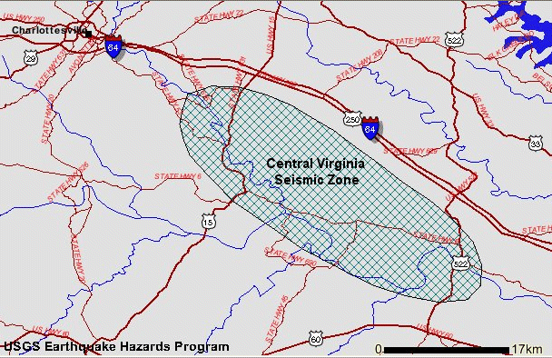
Giles County and Central Virginia seismic risk areas in Virginia
Source: US Geological Survey (USGS), Earthquakes in Virginia and Vicinity 1774 - 2004
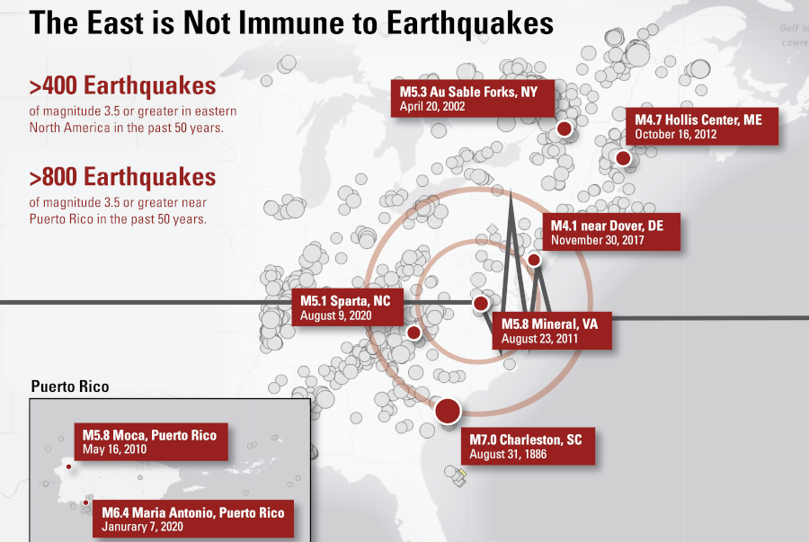
The United States east of the Mississippi has many fewer earthquakes than does the west, and western quakes are stronger. However, the less-intense eastern earthquakes can cause damage further away from their origin.

earthquakes are felt at greater distances in the eastern part of North America, because bedrock in the western states (especially in Los Angeles/San Francisco area) has more faults that diffuse the energy
Source: US Geological Survey (USGS) Magnitude 2.3 Earthquake in Virginia
Waves from eastern earthquakes can travel farther that in the west, where the underlying topography is so chopped-up - like a brick patio - that the energy of a quake is dissipated closer to the epicenter.
Virginia experiences shaking from earthquakes that occur as far away as Missouri
Source: US Geological Survey (USGS), Advanced National Seismic System
In the east the underlying bedrock is pretty well-connected, like a concrete slab. When a section of the crust breaks free of its adjacent neighbor, the crack starts at the location called the hypocenter several miles underground. On the surface, that location is called the epicenter.
The crack propagates through the bedrock until the energy is dissipated and the crust no longer splits and moves apart. More-intense ruptures displace more crust and create underground cracks that extend for greater distances. Ruptures that propagate for longer distances, moving more bedrock, have a greater impact at the surface.
The Modified Mercalli Intensity Scale are now used to measure the effect of an earthquake on people and structures on the Earth's surface. The US Geological Survey (USGS) measures 10 Modified Mercalli Intensity levels or scales. An earthquake not felt by anyone has an "intensity" of MMI I. A moderate MMI V earthquake will generally be felt by people indoors and outdoors, and may break some windows.
Observed effects determine the Modified Mercalli Intensity Scale assigned to an earthquake, so assigning a scale is a judgement call. The old Richter scale developed in the 1930's for measuring the size of California earthquakes was based on the amplitude of the waveform that recorded the shaking on a particular type of seismograph. The Richter scale did not account for how local geology altered impacts on the surface, but variants on that scale are still used to quantify the movement of rock and the energy released in an earthquake.
Typically the US Geological Survey publicity about the magnitude of a modern earthquake is based on the "moment magnitude" (Mw) scale, not the "energy magnitude" scale. For the benefits of news media, a comparison to other well-known earthquakes may be provided as well. For example, the 2011 earthquake centered near the town of Mineral in Louisa County was reported as a 5.8 moment magnitude event.
Because the scales measure different thing, an earthquake will have just one magnitude, but many intensities based primarily upon the distance from the hypocenter. The further away from the hypocenter, impact on the surface will be less. The further away, the same earthquake will be assigned lower numbers on the Modified Mercalli Intensity Scale.
In the 7.9 magnitude 1906 San Francisco earthquake, the San Andreas Fault shifted for almost 300 miles. In the 9.2 Great Sumatra earthquake, the cracking and rock movement underground extended for 750 miles.
The splitting underground moves very fast. Until recently, the maximum speed at which rock cracked was thought to be 7,200 miles per hour (two miles a second). A 2020 earthquake suggests that if a fault is straight or if the friction between moving bedrock is lower than average, the initial cracking that triggers earthquakes at the surface may be 50% faster.
The depth of a hypocenter and the distance that a rupture travels from the hypocenter affect how surface waves cause the earth to move vertically and horizontally at the surface. Rayleigh and Love waves move at different rates and amplitudes, triggering different impacts on human-made structures.
The speed at which a rupture travels underground also helps to determine how the earth will shake at the surface:4
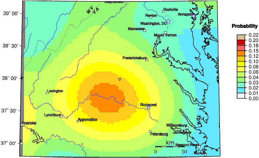
The potential "hazard" of an earthquake in Virginia is rated as Medium-Low by the Virginia Department of Emergency Management (VDEM). Government agencies still prepare for earthquakes as a potential "risk." Risk reflects the potential of harm occurring. The Virginia Department of Emergency Management recognizes earthquakes as "low probability, high-consequence events" and assesses risk by evaluating:
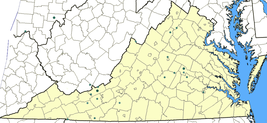
epicenters of Virginia earthquakes between February 1774 - April 2022
Source: Virginia Department of Emergency Management (VDEM), Commonwealth of Virginia Hazard Mitigation Plan (Figure 3-40)
Earthquakes in Virginia that are powerful enough to damage human-built structures are a rarely-experienced event, but the Virginia Department of Emergency Management estimates that a magnitude 6.0 event would destroy almost 3,000 structures beyond repair. The risk is high enough to justify preparation for finding people trapped in collapsed buildings and redirecting traffic after bridges are damaged:5

potential for earthquakes are greater in Central Virginia and Southwestern Virginia
Source: US Geological Survey (USGS) Virginia Seismic Hazard Map
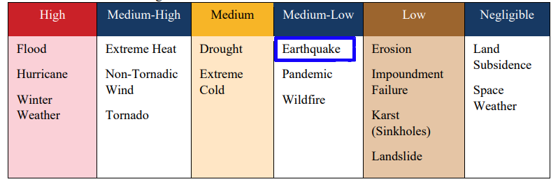
in 2023, the Overall Hazard Ranking of an earthquake in Virginia was rated as Medium-Low
Source: Virginia Department of Emergency Management (VDEM), Commonwealth of Virginia Hazard Mitigation Plan
There is the risk of an earthquake in every physiographic province. Since European colonists arrived, fewer quakes have been recorded in the Coastal Plain. but records since 1607 are just a blip in geologic time. A 1995 earthquake with th hypocenter on the Peninsula near York River State Park was felt by people in Camp Peary. The 1886 earthquake in Charleston, South Carolina demonstrates there is still a risk that Hampton Roads could be seriously shaken and stirred. Similar Magnitude 7 quakes are expected to occur roughly every 500-600 years at Charleston.
Two zones in Virginia are more susceptible to earthquakes than others, and can be identified by the rivers which follow those faults. The James River follows the Central Virginia Seismic Zone between Charlottesville and Richmond, while the New River follows the Giles County Seismic Zone from Radford to the West Virginia border.
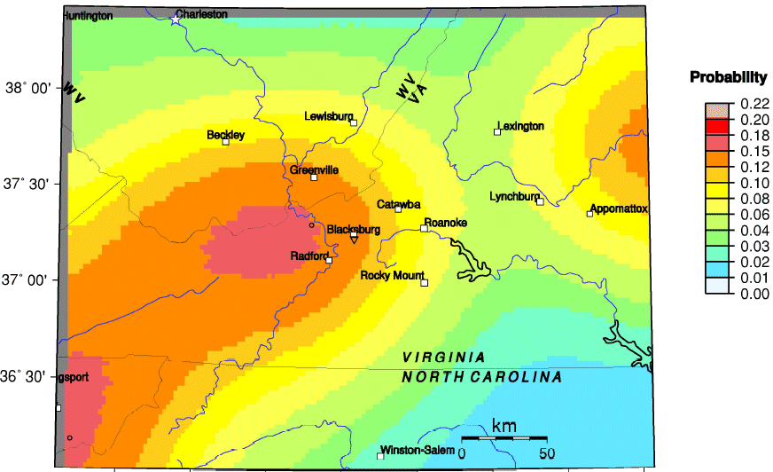
probability of earthquake greater than 4.75 magnitude within next 100 years (southwest Virginia)
Source: US Geological Survey (USGS), Earthquake Probability Mapping
Virginia is pretty stable, but just about any place in the state can experience an earthquake. Manassas was surprised by a 2.5 magnitude tremor in 1997, and an equivalent earthquake was felt in Culpeper two months earlier. Near the southern edge of the Culpeper Triassic basin, a magnitude 3.2 earthquake rattled Charlottesville in 2001. On May 6, 2025 there was a 3.0 earthquake with an epicenter south of Dillwyn. The origin was 5 miles deep. Shaking was felt clearly from Lynchburg to Richmond, and north to Charlottesville.
,
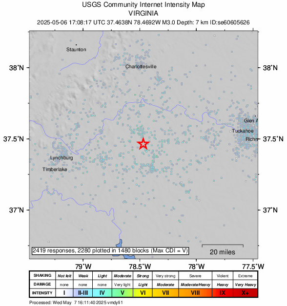
shaking from a 3.0 magnitude earthquake in Central Virginia in 2025 was felt between Lynchburg to Richmond, and north to Charlottesville
Source: US Geological Survey (USGS), M 3.0 - 8 km S of Dillwyn, Virginia
The 1997 earthquake in Manassas was a tiny 2.5 magnitude tremor, but was clearly felt in the Northern Virginia area. One local person's description was drawn from James Bond novels, with a report of being "shaken, not stirred" after hearing what sounded like an unusually large sonic boom. She checked to see if a tree had fallen on the roof, before realizing she had felt an earthquake.
Another resident, whose house was above the epicenter, was awoken from a deep sleep. For years she had avoided traveling to California from a fear of earthquakes, but had returned the previous day from San Francisco. She did experience an earthquake, but it occurred while napping in her own bed in Manassas.
As reported in the Washington Post the next day:6
epicenters of "significant" - felt by people - earthquakes in Virginia
(up to 2009, does not show 2011 quake)
Source: US Geological Surver (USGS), National Atlas
The first seismometer in Virginia was installed at Blacksburg in 1963, and in 2020 only Virginia Tech and the Fredericksburg Geomagnetic Observatory in Corbin had an operational seismometer. In the past, earthquake recorders have been installed at the University of Richmond, J. Sargeant Reynolds Community College in Goochland, Randolph College Riding Center in Lynchburg, Virginia Western Community College in Roanoke, Chippokes State Park near Surry, plus in or near Charlottesville, Cuckoo, Petersburg,
The first recorded earthquake in Virginia occurred on February 21, 1774. In Petersburg, it knocked houses off their foundations. Thomas Jefferson's family fled the house at Monticello to the lawn, and an aftershock a day later caused the Rivanna River to rise over its banks. Elizabeth Jefferson, the mentally-challenged sister of Thomas Jefferson, disappeared after the first quake; she was found three days later dead in the river.
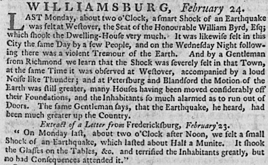
the 1774 earthquake was a minor news item in Williamsburg
Source: Virginia Chronicle, Virginia Gazette (February 24, 1774, p.3)
Jefferson also felt the New Madrid earthquake; it woke him at Monticello before dawn on December 16, 1811. In Norfolk, the clocks stopped and:7
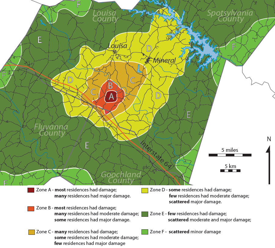
The largest earthquake to strike Virginia recently occurred on August 23, 2011. A magnitude 5.8 quake was centered near Mineral, Virginia (followed by a 4.5 aftershock) in the Central Virginia Seismic Zone. In 2003, a 4.5 magnitude quake had struck nearby in Goochland County.
In the August 23, 2011 earthquake, rumbling/shaking lasted 10-15 seconds and triggered buildings to be evacuated between New York City to Richmond. Modern technology is fragile, and the two nuclear power plants 11 miles away at Lake Anna shut down automatically. It was the first time in North America that an earthquake forced a nuclear reactor offline.
Buildings on the Fairfax campus of George Mason University were closed after the Mineral quake. Urban workers in Washington DC took the rest of the afternoon off, and a classic traffic jam developed on Northern Virginia highways.
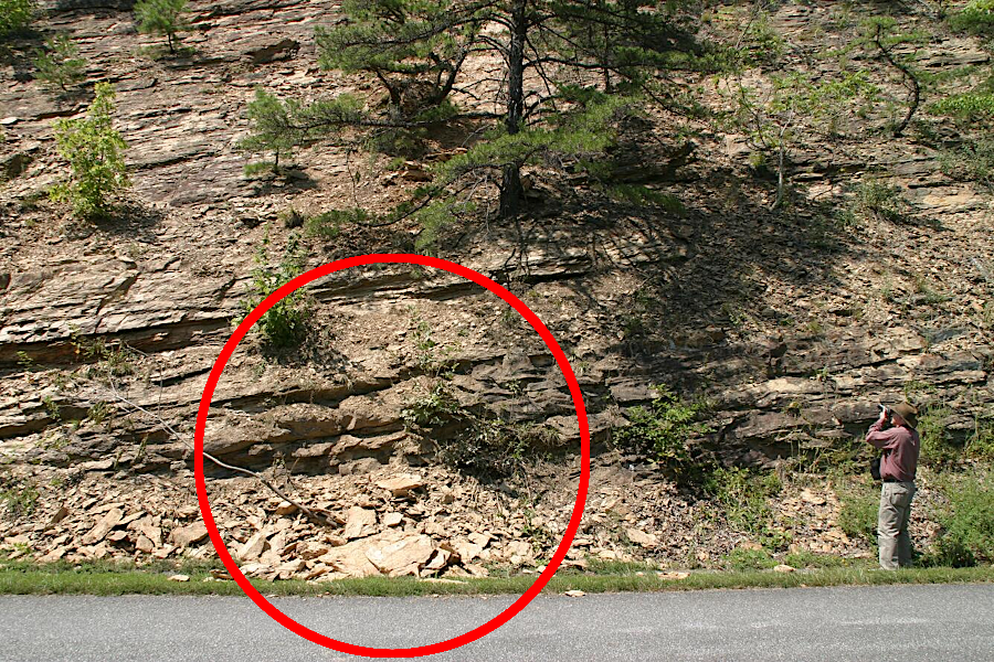
the 2011 earthquake in Louisa County caused a minor landslide on the Blue Ridge Parkway near Roanoke
Source: US Geological Survey (USGS) Photographing Rock Fall Triggered by 2011 Virginia Earthquake
The quake caused $200-300 million in damages. Gargoyles fell from the National Cathedral in Georgetown. The Washington Monument cracked, closing it for several years and requiring a $15 million repair project. It required over five years to repair the elevator.
In downtown Fredericksburg, the Columbia Gas pipeline sprung a leak. The company discovered natural gas leaking into the storm and sanitary sewer system, and buildings were evacuated until repairs were completed.
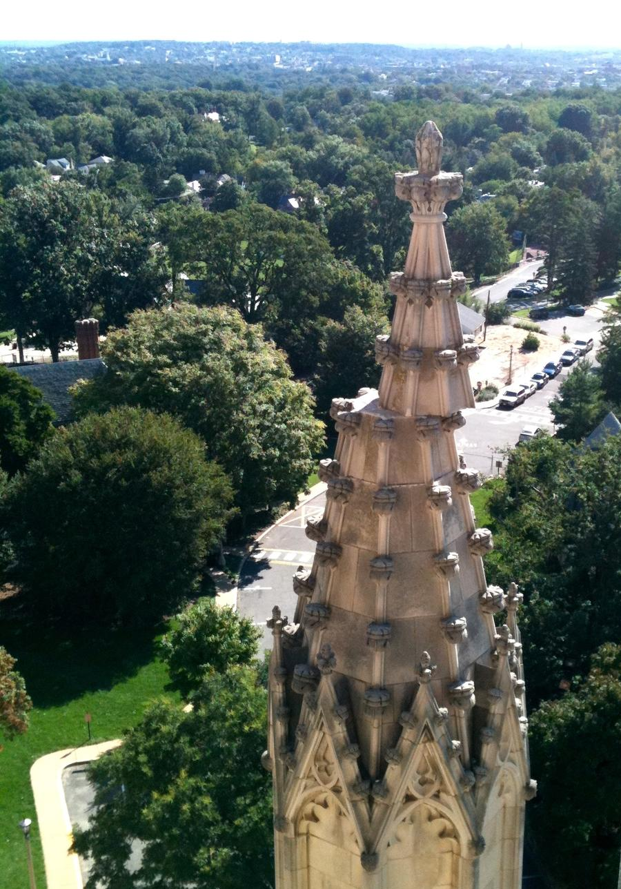
the 2011 earthquake displaced the top of a tower at the National Cathedral in Washington, DC
Source: US Geological Survey (USGS), Damage to Washington National Cathedral
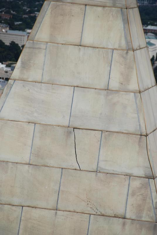
the 2011 earthquake at Mineral cracked stones in the Washington Monument
Source: US Geological Survey (USGS), Washington DC Stone and Brick Buildings Vulnerable to Distant Quakes
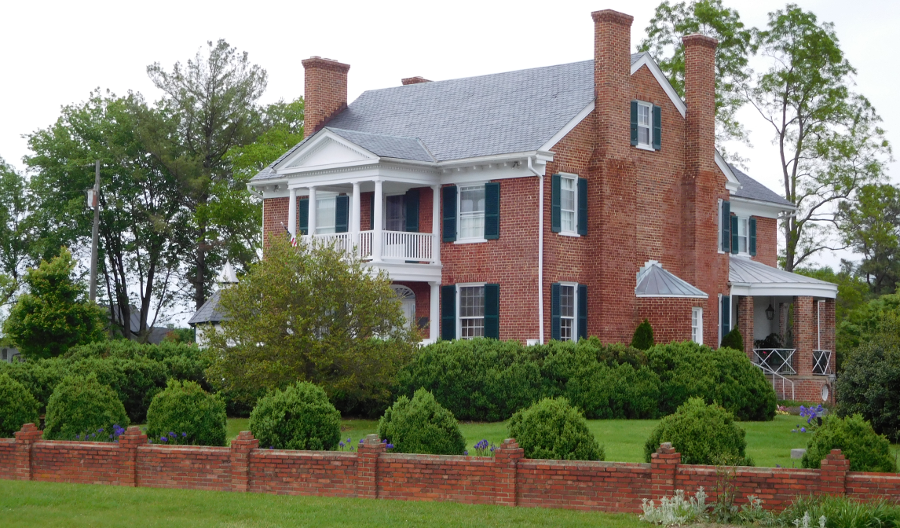
In Culpeper County, the chimneys at the historic Salubria house cracked. The Levy Building in the town of Culpeper, built in the 1800's, was damaged so severely that it was demolished and replaced by a small park.
In Louisa County near the epicenter of the quake, the chimney at Cuckoo collapsed and the quake caused $80 million in damage. Thomas Jefferson Elementary School and Louisa High School were damaged so heavily they had to be razed and replaced.8
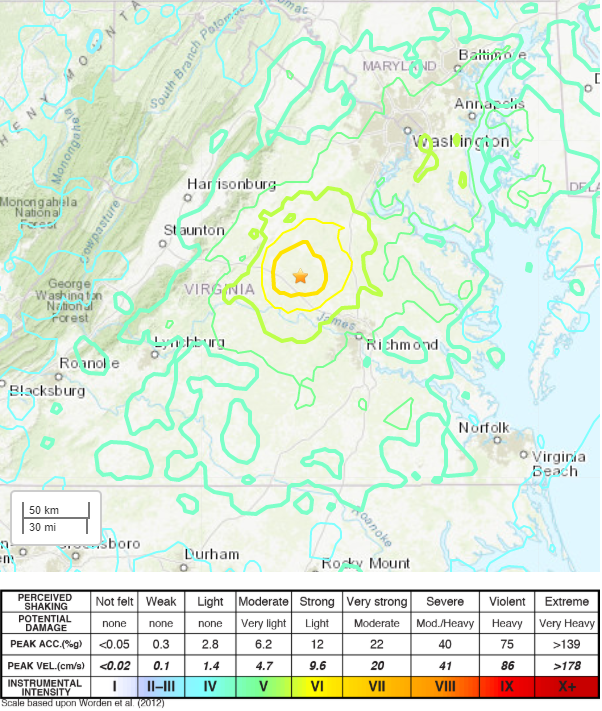
how people in different areas reported feeling the 2011 quake
Source: US Geological Survey Earthquake Hazards Program, M5.8 August 23, 2011 Mineral, Virginia
Water as well as land is affected by the earth shaking. When the August, 2011 quake hit, fish jumped out of Lake Jackson in Prince William County, and later that day at least one homeowner near Manassas reported that water from a private well had turned brown. As seismic waves moved through bedrock, compressing and then relaxing, groundwater levels changed in wells monitored by the US Geological Survey over 350 miles away. In most cases, water levels moved up and down about 6 inches, but the rise and fall was over 25 inches in one Pennsylvania well.9
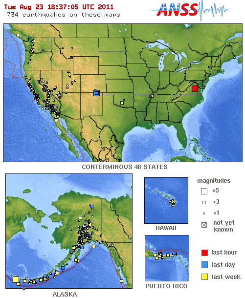
a rare image: "Latest Earthquakes in the USA - Last 7 days" shows August 23, 2011 earthquake
Source: US Geological Survey
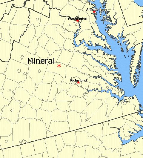
location of Mineral, in Louisa County - and Central Virginia Seismic Zone
Source: USGS National Atlas
The 2011 Mineral quake appeared to be associated with the Spotsylvania high-strain zone, the boundary between the Goochland and Chopawamsic terranes. Those terranes are chunks of continental crust that were squeezed onto the North American continent as the Iapetus Ocean closed during the Paleozoic era. The edges of different terranes are zones of weakness, and potential sites of future earthquakes that relieve stresses that build up within the bedrock of Virginia as the North American Plate drifts westward.
The Chopawamsic Terrane was a volcanic island arc that formed in the Ordovician period. Before the island arc was accreted onto Virginia, it was similar to Japan or the Aleutian Islands today. During the Taconic orogeny, as the Iapetus Ocean closed, the Chopawamsic Terrane was pushed by tectonic motion and plastered onto the edge of an expanding continent. In addition to the location of the suture between terranes, faults were created as the chunks of continental crust were squeezed together.
The 2011 Mineral earthquake occurred about 5 miles below the surface, on what was named the Quail Fault. The shaking at the surface was concentrated west of the epicenter, since the fault is tilted to the southeast rather than vertical. Bedrock southeast of the fault was thrust upward relative to rocks to the northwest. Geomorphic evidence from the incision of river channels across the Piedmont in the area suggests that earthquakes similar to the 2011 event at Mineral occur on the average every 5,500 years.
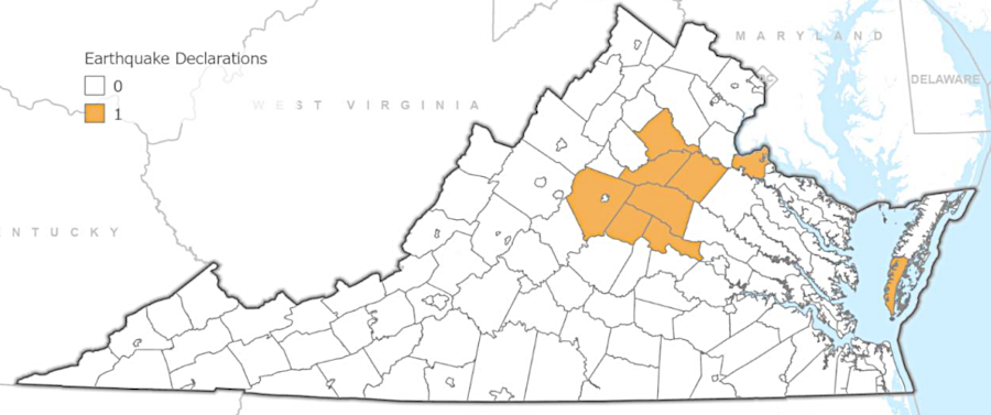
after the 2011 Mineral earthquake, counties included in the presidential disaster declaration stretched from the Blue Ridge to the Atlantic Ocean
Source: Virginia Department of Emergency Management (VDEM), Commonwealth of Virginia Hazard Mitigation Plan (Figure 3-11)
A few small sand boils erupted where groundwater liquified a zone of sediments, but there was no rupture at the surface. Later research documented evidence of liquefaction from one or two earthquakes within the last 500 years at three sites on the James and Pamunkey Rivers. An earthquake greater than 6.0 magnitude within the last 4,500 years left liquefaction features on the Mattaponi, Pamunkey, and South Anna Rivers, plus a tributary of the Rivanna River (Stigger Creek).
The Atlantic Coastal Plain sediments amplified the seismic energy released by the quake. Shaking was particularly strong to the northeast, reflecting the northwest–southeast trend of faults and suture lines of terranes that were formed during the Paleozoic Era.
However, the Central Virginia Seismic Zone is oriented east-west. The pattern of stresses and "breaks" deep underground that result in earthquakes is not aligned with the north-northeast regional strike of faults in the Piedmont bedrock.
The Giles County Seismic Zone also has a different alignment. It is oriented north-northeast, in a pattern separate from the regional east-northeast strike of bedrock in that part of the Valley and Ridge physiographic province. Earthquakes in the Eastern Tennessee Seismic Zone appear to be aligned with an aeromagnetic anomaly known as the New York-Alabama lineament, and the earthquakes there are roughly aligned with regional strike of faults in the bedrock.
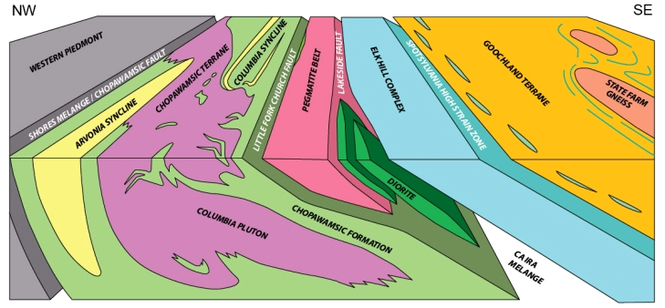
geologic structures within the Central Virginia Seismic Zone include various terranes that were accreted onto the edge of the North American tectonic plate in the Paleozoic era, with fault lines between the terranes
Source: Virginia Department of Mines, Minerals and Energy, Major Earthquake 2011
The Central Virginia Seismic Zone includes the Goochland Terrane, with the State Farm gneiss. The terrane, a chunk of continental crust, formed as an island arc in the Iapetus Ocean prior to the Taconic orogeny.
Before the Iapetus Ocean began to close, the Goochland Terrane was located near Manhattan and perhaps further to the northeast. As the continental plates moved, the Goochland Terrane migrated southwest and merged into Virginia on the eastern side of the Chopawamsic Terrane. The suture line where different chunks of crust came together is a fault zone dipping 45° to the southeast, revealed by the depth of aftershocks subsequent to the 2011 Mineral quake.10
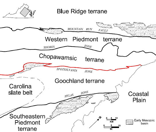
location of Spotsylvania high-strain zone
Source: US Geological Survey Circular 1264, Geology of the National Capital Region - Field Trip Guidebook
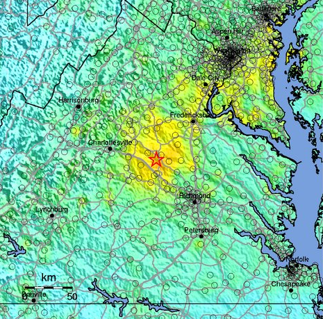
intensity of ground motion in 2011 Mineral quake
Source: US Geological Survey, Shakemap us082311a
Just before midnight on December 22, 1875 an earthquake with an estimated magnitude of 4.8 was centered in Goochland and Powhatan counties in the Central Virginia Seismic Zone. That earthquake was felt between Baltimore and Greensboro, North Carolina, and caused significant damage in Richmond.
The other "big one" in Virginia (about a 5.8-6.0 on the Richter scale) was on May 31, 1897, in Pearisburg, the county seat of Giles County. The judge in the courthouse adjourned a trial, jumped over the railing, and fled outside with everyone else as the courthouse rattled, brick walls cracked, and chimneys fell over.11
It was one of Virginia's most powerful recorded earthquakes - but our recorded memory extends back only a few centuries, while the geologic history of the state extends back hundreds of millions of years. In 1959, Giles County was shaken again by a 3.8 temblor, and windows were broken in the 1975 Veterans Day earthquake in Blacksburg.
<> The largest quake identified in human history is a 9.5 magnitude megaquake in Northern Chile about 3,800 years ago. In recent times, the 1960 Valdivia earthquake in southern Chile was between 9.4 and 9.6.12
Source: USGS Earthquake Hazards Program - Quaternary Fault and Fold Database
Oklahoma is experiencing a swarm of mild earthquakes triggered by drilling for oil/natural gas and/or by deep injection of fluids left over after oil/gas well development. In Virginia, the story is different.
There has not been a sudden increase in the number of earthquakes in Virginia due to drilling, because there has not been a major increase in drilling. Virginia has only a handful of oil wells, and most natural gas wells produce methane from layers of coal too deep to mine economically. There is potential for fracturing ("fracking") sedimentary layers in the Taylorsville Basin northwest of Fredericksburg, but commercial development of hydrocarbon resources by fracking has not occurred there yet.
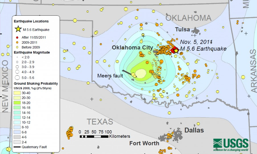
drilling for oil and gas, and injection of drilling fluids, has lubricated faults in Oklahoma and triggered earthquakes
Source: US Geological Survey (USGS), Oklahoma Struck by Series of Quakes
Nonetheless, the number of earthquakes in Virginia is "increasing" - because geologists are getting better at recording earth tremors. New sensors have been installed to identify the smaller quakes.
In the 25 years between 1978-1993, there were over 160 recorded earthquakes in Virginia, but only one-two per year (16% of those recorded by seismographs) were felt. Now more seismographs have been installed, so the percentage of earthquakes felt-by-people vs. recorded-by-scientists is even smaller. Until the 1970's, almost all recorded quakes in Virginia were just the ones strong enough to be felt. Prior to the coal and timber boom in the 1880's, there were not that many people in western Virginia to provide reports from personal experience from the Giles County Seismic Zone.13
The old tale that "lightning does not strike twice in the same place" is not true for lightning, and certainly not true for earthquakes. Louisa County, where the 5.8 magnitude quake struck in 2011, experienced a magnitude 2.3 earthquake again on May 15, 2013. Similar to the 2011 quake, that particular aftershock was triggered by a shift in the crust 3-4 miles deep. By May 15, 2013, seismographs had recorded 450 aftershocks, including 50 that were felt by people and 38 aftershocks that were at least 2.3 magnitude.14
probability of earthquake greater than 4.75 magnitude within next 100 years (central Virginia)
Source: USGS Earthquake Probability Mapping
Homeowner insurance policies typically exclude coverage for an earthquake. When a house in Virginia is damaged by an earthquake, homeowners must pay for repairs out of their own pocket - unless the President declares a Federal disaster. After the 2011 quake, the Federal Emergency Management Agency (FEMA) recommended against Federal disaster relief, using the Preliminary Damage Assessment to determine that local/state governments could absorb the costs of recovery. However, Governor McDonnell appealed the FEMA recommendation.
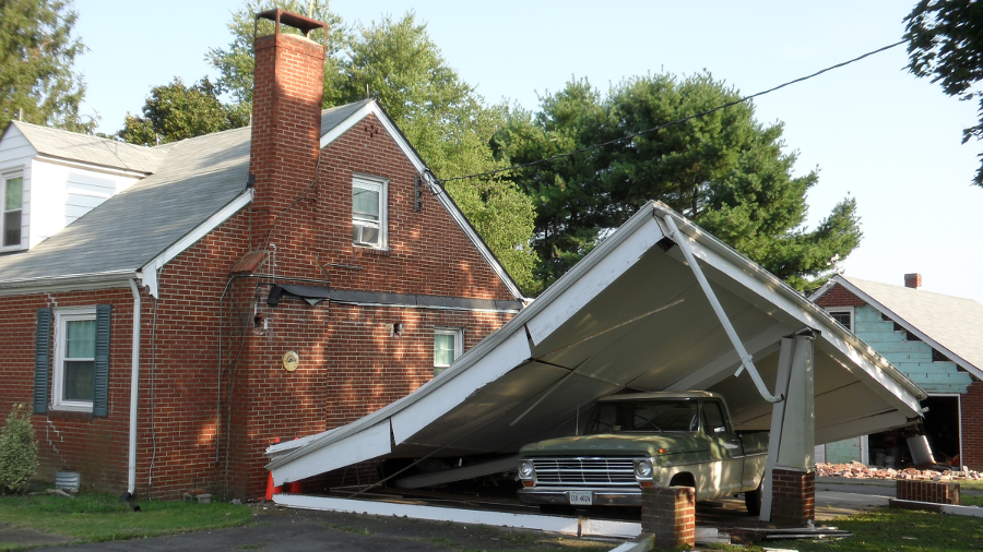
bricks were displaced from homes and garages in Louisa County during the 5.8 magnitude quake in 2011, and at least one carport collapsed
Source: Virginia Tech, Virginia Tech researchers offer aid after Virginia earthquake
In November, 2011, President Obama authorized Individual Assistance to provide grants to private homeowners, of which 98% lacked insurance for earthquake damage. The president soon expanded his disaster declaration to authorize Public Assistance, which provided Federal funding to rebuild public facilities such as Louisa County schools. The Federal Emergency Management Agency ended up paying out $19 million in Louisa County, and another $13 million in nine nearby jurisdictions.15
greater ground movement near a quake's epicenter results in greater damage to structures
Source: Virginia Department of Mines, Minerals and Energy, Major Earthquake 2011
Much of the damage in Northern Virginia was not covered by insurance. The Lake Jackson Dam in Prince William County began leaking in 2012. It may have cracked slightly during the quake, but damage was not obvious for almost a year. The county spent close to $1 million to repair the dam.16
the 2011 earthquake may have cracked the foundation of Lake Jackson Dam in Prince William County, nearly 60 miles away from the epicenter
A monument marking 600 Confederate graves at the Warrenton Cemetery was also affected. Maintenance workers realized in 2013 that the 2,500 pound statue known as "Lady Virginia" had moved several inches from its centered position on top of a 40-foot high granite shaft. The local chapter of the United Daughters of the Confederacy raised funds for the repair.17
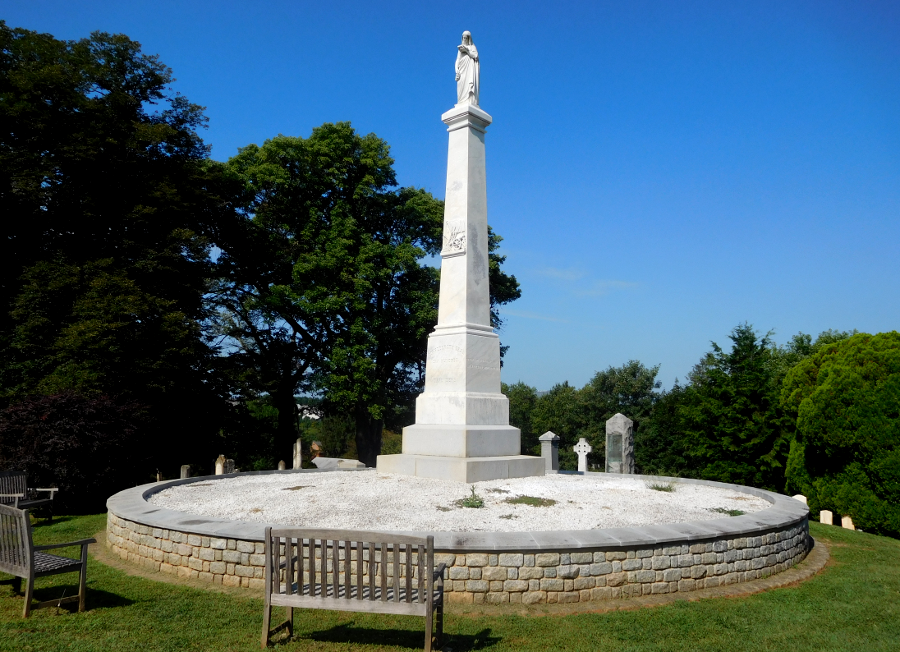
the 2011 earthquake caused the statue known as Lady Virginia to wobble on top of its shaft at Warrenton Cemetery, 60 miles from the epicenter in Louisa County
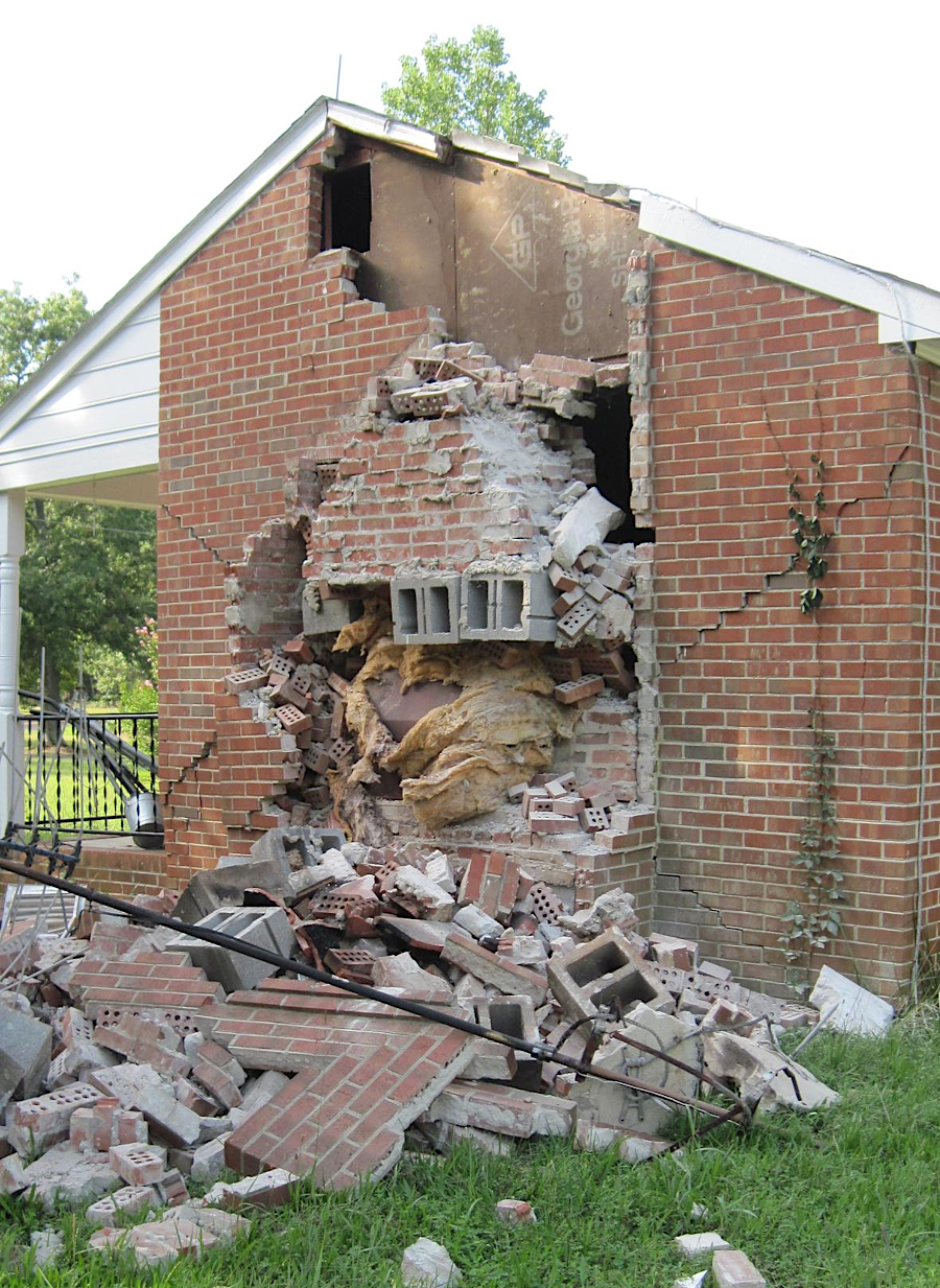
chimney damage at a house in Louisa County from the 2011 earthquake
Source: US Geological Survey (USGS), 10-Year Anniversary of US’s Most Widely Felt Earthquake
To be considered an earthquake, the movement of the earth must be a natural faulting event. Human activity can mimic the effect of an earthquake. Over 60,000 Virginia Tech fans created the equivalent of a 1.0 earthquake when the band Metallica played at Lane Stadium on May 7, 2025.
School tradition is to jump when "Enter Sandman" is played on the stadium's videoboard before the start of football games. That pattern is an accidental tradition. It started one night when a member of the college band was cold and jumped to warm up. Other band members joined in, followed spontaneously by the crowd.
The fan response to Metallica's live rendition of the song in 2025 was recorded in seismographs located on the Virginia Tech campus, in what was quickly labelled the "Metallica Quake." Three previous times, in 2011, 2015 and 2021, fans have been so energized at a football game that their jumping was also recorded as seismic activity.18
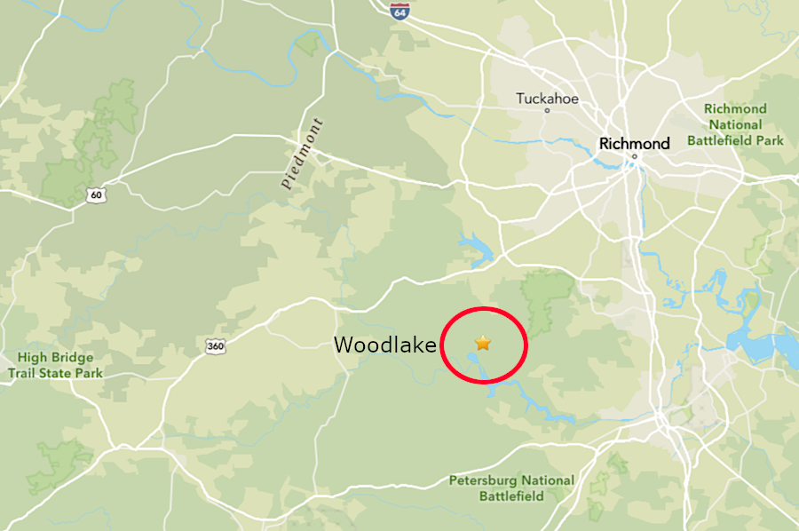
a 2.4 magnitude quake occurred southwest of Richmond on March 20, 2026
Source: US Geological Survey (USGS), M 2.4 - 11 km S of Woodlake, Virginia
Small quakes continue to occur in Virginia. A magnitude 2.2 earthquake occurred near Independence on February 23, 2026. The earth moved about 5 miles deep, and then the surface shifted slightly in response. A 2.4 magnitude quake occurred at Woodlake, southwest of Richmond, less than a month later on March 20.
As described in one news story:19
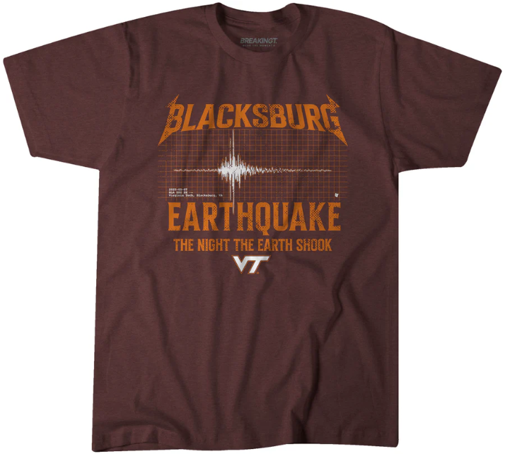
Virginia Tech fans mimicked seismic activity when jumping as Metallica played "Enter Sandman" in a live performance at Lane Stadium
Source: BreakingT, Virginia Tech: Blacksburg's Earthquake
the chimneys of the historic home at Cuckoo in Lousia County had to be repaired after the 2011 quake
earthquakes occur regularly in and around Virginia; the tectonic plate has cracks (faults) that move
Source: US Geological Survey (USGS), 2011 Virginia Earthquake - Infographic

compared to other parts of the United States, Virginia has relatively low risk of damaging earthquakes
Source: US Geological Survey (USGS) 2008 National Seismic Hazard Maps (showing 5% probability of exceeding 5Hz/0.2 Seconds Peak Ground Acceleration in 50 Years within Conterminous U.S)
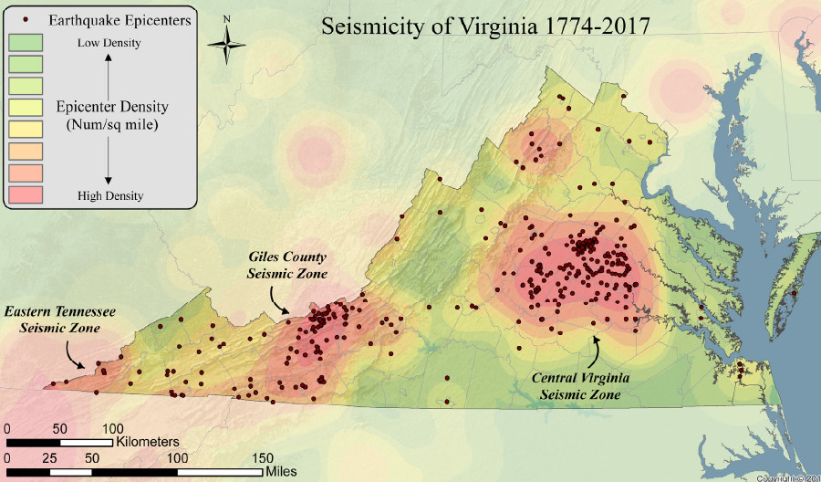
the three seismic zones in Virginia are defined by the frequency of earthquakes
Source: Virginia Department of Energy, Mapping Seismic Hazards in Virginia and Seismic History of Virginia (Figure 5)