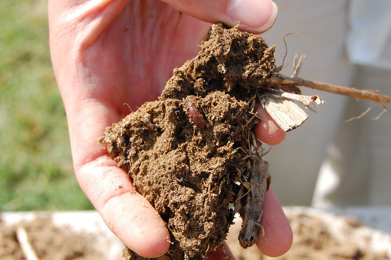
healthy farm soil has a high percentage of carbon and a structure that allows for water to flow around roots
Source: Chesapeake Bay Program, Midway Farms in Richmond County, Virginia
healthy farm soil has a high percentage of carbon and a structure that allows for water to flow around roots
Source: Chesapeake Bay Program, Midway Farms in Richmond County, Virginia
Bedrock is the starting point for soil formation; soils are a land feature which have been created from the decomposition of bedrock. A crystalline "basement" of metamorphic rock is buried underneath all of Virginia. It was formed in the Grenville Orogeny over one billion years ago, as the supercontinent Rodinia formed. Soils formed directly from that 1+ billion year old rock where it is exposed on the surface at spots on the Blue Ridge such as Old Rag Mountain, and from the lava (Catoctin Formation) which coated it when Pangea broke up about 600 million years ago.
In the Piedmont, the bedrock which is the source of modern-day soils was formed originally in island arcs (like Japan) or chunks of continental crust (like Madagascar). Those tectonic slices were shoved onto the North American tectonic plate in orogenies, as the addition of separate terranes led to the formation of Pangea. The metamorphosed bedrock underneath soils in the Piedmont is exposed primarily in stream channels, especially at knickpoints such as Nottoway Falls, and at the Fall Line.
At the Fall Line, the depth to the metamorphic bedrock is shallow;. The depth gets deeper further to the east, covered by sediments which eroded off the Ancestral Appalachians over the last 200 million years. The Coastal Plain sediments are 6,000' thick at the edge of the Atlantic Ocean. Further east, offshore, the sands and muds covering the Outer Continental Shelf are described as marine sediments rather than as underwater soil.
Soils in the Coastal Plain, the Valley and Ridge, and the Appalachian Plateau formed from decomposition of bedrock in sedimentary formations rather than the crystalline basement. There are also a few places where basalt dikes brought igneous material to the surface as Pangea broke apart, and a few spots (including Mount Rogers and Mole Hill) where volcanic lava reached the surface at other times.1
Soil is typically the top part of the earth's crust on continents. It develops over time as bedrock is modified by biogeochemical processes.
Physical and chemical weathering slowly decomposes bedrock to form the red clay soils which are most common in Virginia, especially in the Piedmont physiographic province. Transformation over time due to changes in heat, pressure, and exposure to water, air, and biological activity alters lifeless rock into a soil enriched with organic material. Pedogenesis alters the texture and structure of the original mineral particles and typically adds organic material.
As erosion removes the surface, heat and pressure on buried bedrock are reduced. Exposure to air, water, and biological organisms causes molecules in crystalline minerals to realign; minerals formed under higher temperatures/pressures transform and recrystallize into different minerals. Gaps between crystals change as the shapes of new molecules align differently, creating wider spaces for water and air to migrate underground.
Deeper soils form in more humid climates, where more water is available to interact with the bedrock for longer periods of time. At depth the parent material remains intact, but near the surface the bedrock loses about a third of its mass as minerals dissolve and wash away.
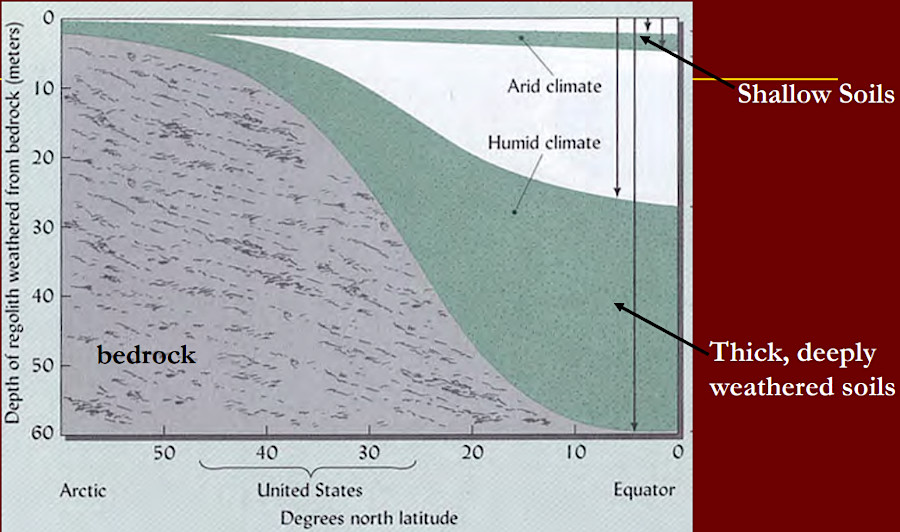
deeper soils develop in humid environments, where more water can interact with bedrock and support organic life
Source: Dr. Steven C. Hodges, The Water Cycle and Water Balance in Nutrient Management
The original fabric and structure of the metamorphic formations in the bedrock remain intact as "saprolite" begins to form from inorganic weathering, as much as 100 feet deep in the Piedmont. Closer to the surface, where organic processes have greater impact, the minerals bear less resemblance to the parent material. The porosity and permeability of the soil changes. Soils with a high percentage of clay may block water transport and create perched water tables that interfere with root growth.2
At the surface, microscopic forms of life (plus earthworms and other burrowing creatures) convert saprolite into soil. Other major factors that determine what type of soil develops at a particular location are climate, topographic relief, biological organisms, and time.
In Virginia's Piedmont, saprolite is typically 30-60 feet thick. Bedrock is transformed into saprolite at the rate of 12 or more feet every million years. Together, soil and saprolite are known as "regolith."3
Home gardeners refer to digging in "dirt," staining their gloves and clothing with soil. A soil scientist at Virginia Tech, who won the individual competition in an international soil judging contest at the 2022 World Congress of Soil Science, described the difference between soil and dirt:4
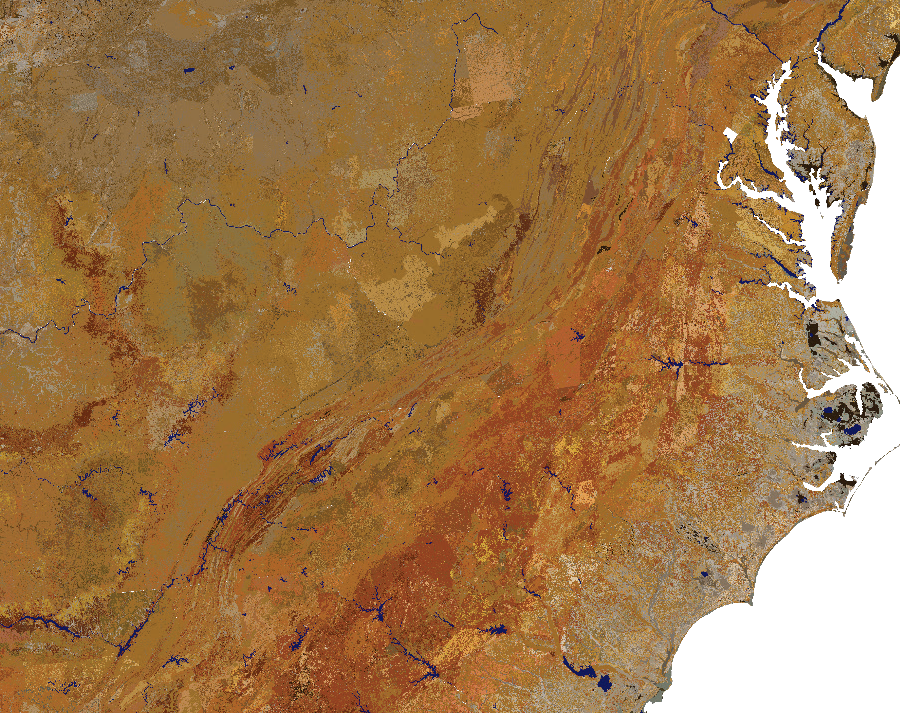
soil colors in Virginia and rearby states at 25cm (10") depth
Source: Natural Resources Conservation Service (NCRS), Soil Colors of the United States
Soil has, in addition to mineral material derived from weathered bedrock, a mixture of organic matter, air, water and living things. The texture of soil is determined by the percentage of soil particles with different sizes. Sand, silt, and clay particles clump together into aggregates called "peds."
Sand particles are between 2.0 and 0.5mm and feel gritty to the touch. Silt particles resemble flour. They are between 0.5-005mm and feel smooth. Clay particles are less than 00.5mm and feel sticky. To compare equivalency of sizes, if sand particles are considered to be basketballs then silt particles would be the size of a ping-pong ball; clay particles would be a pea.5
Aluminosilicate minerals in parent bedrock, particlularly in feldspar, decompose into kaolinite clays. Other major types of clays that form are smectites such as montmorillinite, which expand and contract in the presence of water, plus vermiculites and illites.
Clay particles align in a layered crystal lattice structure that reduces permeability within soil. Sediments with a high percentage of clay become confining aquifers, blocking the vertical movement of groundwater.6
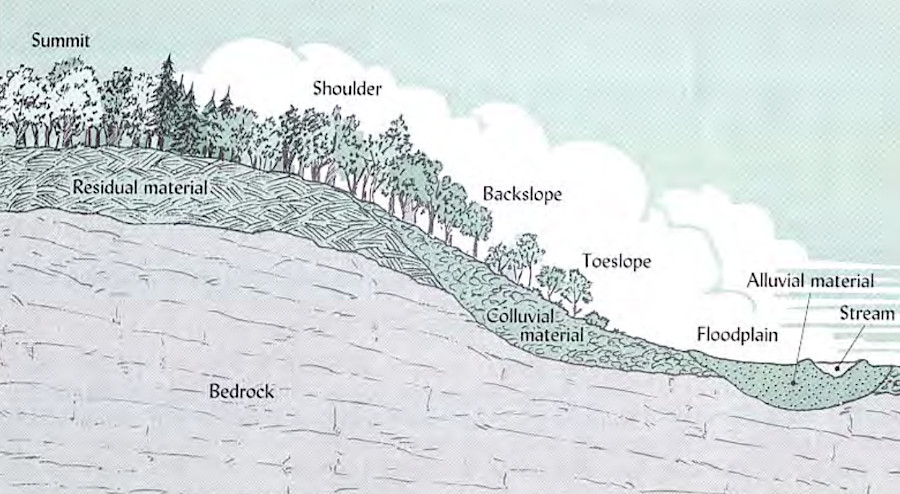
European colonists recognized that soils eroded from ridges, moving downslope, so they patented land in the floodplains first
Source: Dr. Steven C. Hodges, The Water Cycle and Water Balance in Nutrient Management
When clay particles block the pores between soil particles, a clay-rich soil becomes saturated and roots can not obtain oxygen easily. Trees that are able to survive with "wet feet," such as boxelders and sycamores, out-compete pines, oaks, and other species to dominate the forest cover on floodplains in stream valleys.
Soils mapping began about 6,000 years ago by farmers in China. Starting about 3,000 years ago, Native Americans identified soils with a high percentage of clay and made unglazed earthenware pottery. Europeans brought the tradition of baking the clay at higher temperatures to manufacture bricks.
Soils are classified according to distinct characteristics and ecological significance. The United States Department of Agriculture (USDA) has identified 12 "orders" of soil. Ultisols are the most common in Virginia. They are:7
Ultisols are subdivided into six suborders, of which Udults and Aquults are present in Virginia. Udults developed in forests with a mixture of hardwood and softwood species, with a relatively small percentage of humus. Aquults also developed in forested areas, and typically on the flat Coastal Plain where the water table was high for at least part of the year.8
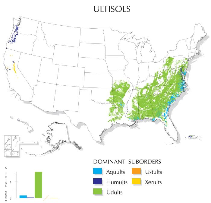
of the 12 soil orders, ultisols that include red clay are the most common in Virginia and the southeastern states
Source: Natural Resources Conservation Service (NRCS), Ultisols; Soil Orders Map
More-detailed taxonomic classifications of unique soils are based on the fertility, permeability, erodibility, capacity to support structures, and other characteristics. Color and texture are key characteristics used to map different soils. Differences in the original parent bedrock and how it has been altered over time result in different soils.
Soil maps show the boundaries of the phases within a soil series. A series consists of soils with similar profiles - composition, thickness, and structural organization of sand/silt/clay particles into aggregates called "peds." A soil series can be subdivided into phases based on differences which affect how humans interact with the soil, primarily for farming and construction. Phases vary in their texture, slope, erodibility, percentage of stones, salinity, and other characteristics:9
If all the subcategories of a soil series are considered, there are about 5,900 soils in Virginia.10
The Pamunkey soil series is the unofficial state soil. The Natural Resources Conservation Service encouraged each state to make such a designation, to enhance public understanding of soils management. Governor Allen proclaimed the state soil by executive action, only to discover that the legislature retained that authority. Efforts to designate a state soil as an official emblem of Virginia in 1998 and 2010 never received final approval by the General Assembly.
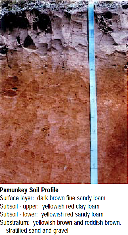
the Pamunkey loam is a highly productive soil for crops such as corn
Source: Natural Resources Conservation Service (NRCS), Pamunkey - Virginia State Soil
The Pamunkey soil series covers 23,728 acres of stream terraces on the Coastal Plain in Tidewater. It is classified as a "fine-loamy, mixed, semiactive, thermic Ultic Hapludalfs." Native Americans recognized its high productivity and located their corn fields on it before European colonists arrived, and the first crops grown on Jamestown Island by colonists were in Pamunkey soil. In addition to its historical significance, it is derived from material which eroded from all five physiographic provinces in the state.11
the state soil is the Pamunkey series, found between the Rappahannock and Appomattox rivers
Source: University of California - Davis, Soil Data Explorer
Soil is different from rock that is weathered by just physical and inorganic chemical processes. Soil is created by organic activity, transforming the saprolite into the material that supports most plant and animal life at the ground's surface.
Soil is divided vertically into horizons. At the top of the ground surface is the O Horizon. It consists of organic material, such as leaves which have fallen from trees. Intense biological activity creates humus there.
Just underneath is the A Horizon. That topsoil is dark because of the high percentage of organic humus mixed in with particles of saprolite. Groundwater, made acidic by the humus, moves by gravity down through the A Horizon.
In the next layer down, the E (Eluviation) Horizon, water dissolves minerals such as calcium and iron along with organic matter and tiny clay particles and carries them down lower. Younger soils may lack an E horizon if there has not been enough rainfall and time for the leaching process.
The leaching process is reversed in the next layer down, the B Horizon. That subsoil is enriched with salts and metal ions removed from the E Horizon. about 50% or less of the particles are decomposing parent material. Nutrients are available to roots, but organic material is more scarce than in the A Horizon.
Below the B (Subsoil) Horizon, there is a much higher percentage of unweathered parent material plus clay particles deposited by groundwater. In construction projects, topsoil (A-B horizons) are removed so building foundations can be placed in the stable subsoil. Organic material decomposes fast, but within the lifetime of building the particles in the C Horizon will not change their shape and will support a structure - unless the clay is a form of clay which shrinks and swells as the percentage of water changes.
At the bottom, unweathered saprolite is the R Horizon. Bedrock in the R Horizon is not soil.12

unweathered bedrock is the R Horizon
Source: Lewi1224, File:Soil Horizons Diagram.jpgr (on Wikipedia)
marl and oyster beds rich in lime were key to soil fertility projects in the mid-1800's
Source: Northeastern University, Travels into North America (by Peter Kalm, 1770, p.97)
Many different factors affect soil formation, creating a wide variety of soils. Fresh and salt water, ice, carbon from decaying plants and animals, root exudates and other chemicals from organic activity, earthworms, and other living creatures gradually affect parent material and transform it into soil near the surface. The horizons of soil near the surface have a higher percentage of carbon from biological activity and can provide carbon sequestration services.
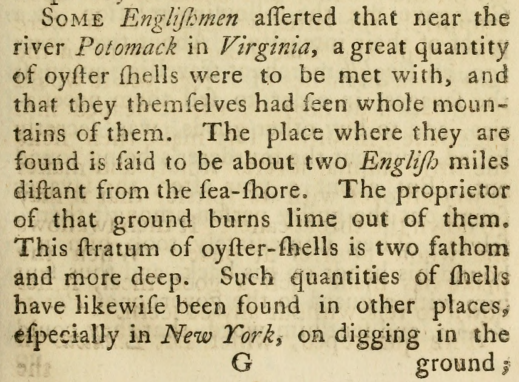
over 20 different soil types are mapped for less than 650 acres in Goochland and Powhatan counties
Source: Natural Resources Conservation Service (NRCS), Web Soil Survey
The organic component in forest soils comes from leaf litter decaying into humus at the surface, forming the O horizon at the surface of the ground. The organic component in grassland soils comes primarily from roots, increasing the percentage of carbon at depth rather than just on the surface.
In Virginia the A horizon will have roughly 2-4% organic material if undisturbed by farm tilling, construction, or landslides.
Residential construction projects typically start by scraping off the organic-rich topsoil and stockpiling it. The relatively sterile subsoil is exposed and pushed around the site during construction to provide mechanical support where needed. When a building is completed, the topsoil is spread back onto the surface and planted with grass seed. The topsoil is essential to establish a future lawn; it is more fertile than the subsoil excavated from greater depth.
Physical disaggregation of molecules and chemical decomposition slowly weather the original minerals into different forms that determine the structure and water-holding capacity of a soil. Bedrock with silica-rich minerals, such as quartz and feldspars, carbonates, and iron oxides can decompose into clays with particles flattened against each other like shingles on a roof, or plates in a kitchen cabinet. That alignment blocks the flow of water. Clay is used to line the bottom of farm ponds, ensuring a watertight seal so the water in the pond does not seep into the ground.
Different types of soils evolve under different conditions and from different source minerals. Soil scientists classify soils by different characteristics using a taxonomy of terms such as "hapludult" and "podzol" that is comparable to the way botanists classify plants and astronomers classify galaxies.
Geotechnical engineers measure the ability of soil to support heavy structures and traffic on roads. Artists creating pottery care about the percentage of clay vs. other impurities in a soil. Farmers care about the ability of soils to grow crops, including the amount of organic material that can provide nutrients and store rainwater:13
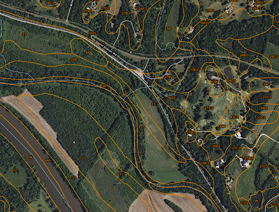
prime farmland in Virginia
Source: Virginia's Land and Energy Navigator (VALEN)
The transformation of dirt into soil, the chemical and physical alteration of bedrock, is facilitated by plant roots. Roots grow to different depths, so the thickness of soil requires making a judgment call. By definition, the depth of soil does not exceed 79 inches:14
Soil rich in organic material can have gaps between particles that store rainfall. Raindrops that seep into the ground fill those gaps. If rainfall is steady, the soil near the surface will become saturated and water will fill gaps between soil particles located deep underground. After the sun emerges again, surface soil particles will be depleted of water through direct evaporation and through evapotranspiration as roots suck water up into plants.
At depth, the gaps remain always saturated with water. The "water table" is a line at depth which makes the boundary between saturated and unsaturated gaps between particles. Below the water table is the phreatic zone; above the water table is the vadose zone.
Plants rely upon groundwater located near the surface in the vadose zone. Almost all roots in Virginia grow in the top two feet of soil. Outside of wetland areas and riparian zones, plants do not grow roots deep enough to reach the water table. The water table is often 10-30 feet deep, far below the level of plant roots. If there is no rain for 10 days during the hot days in July/August, then roots can not access water. At such times plants experience drought stress and leaves curl to conserve water. Continued drought can kill plants.
A 1% increase in organic matter in soil can great the spaces needed to store an extra inch of rainwater. Crops on agricultural fields consume a quarter of an inch of water daily during the growing season. Farmers who increase the organic percentage in their soil can gain extra productivity and profits, as plants in organic-rich soils can continue to grow steadily during long gaps between rainstorms.15
Source: Virginia Extension, Common soil types in different regions of Virginia (January 12, 2015)
The earliest settlers who arrived about 20,000 years ago recognized that soils in bottomlands near rivers had a higher percentage of carbon and were more productive. Planting corn and other crops on hillsides produced less food. Water from storms steadily constantly washes residual soil particles from where they originally formed downhill - thanks to gravity. Those transported soil particles, enriched with carbon from plant roots and decomposing leaf litter, have accumulated on floodplains ever since the Appalachians were uplifted 300 million years ago. Erosion has created and removed floodplains over and over again since the breakup of Pangea.
The quality of soil has shaped the pattern of human settlement. After adopting agriculture about 3,000 years ago, Native Americans farmed where the soil was most productive, on floodplains. The beans grown together with squash and corn "fixed" nitrogen in the soil, but the first Virginia farmers did not fertilize. Unlike the Wampanoag in Massachusetts, the tribes on Virginia's Coastal Plain did not catch herring and put the fish next to the corn stalks in order to provide nutrients.
Crops decline in productivity after a few years of farming the same fields because key nutrients (particularly nitrogen, phosphorous, and potassium) would be removed from the soil and concentrated in plants, or washed away. When plant material such as ears of corn was removed from the field, then the nutrients were lost.
To maintain production, Native America farmers cleared new farm fields next to the old ones. When the new fields were too far away from the town to be convenient, the houses were moved in stages to be closer to the crops. Even a palisaded town would be relocated within 20 years, reflecting the need to access better soil. In the James Rive watershed on the Coastal Plain, Pamunkey soil (now the state soil of Virginia) was preferred due to its productivity.16
English colonists displaced the Native Americans from their farms and towns. As settlers moved inland and searched for high-quality farmland to acquire, they paid close attention to the natural vegetation. Surveyors knew that redbud and walnut trees were a sign of rich soil.17
Colonists planted tobacco as well as food crops. Tobacco extracts a high percentage of nitrogen to form the plant cells. After three or so years, the shortage of nitrogen reduced the harvest. Erosion from lands cleared for tobacco and food crops washed highly-productive topsoil into creeks. Muddy runoff clogged streams with legacy sediments, while reducing the utility of acres which had been cleared with much labor.
Like the Native Americans, colonists then cleared new land and left "old fields" fallow for 20 or more years. As settlement expanded in colonial Virginia, fallow fields filled with grasses and forbs became a common feature of the landscape.
Gradually the nitrogen within the soil would recover, as bacteria fixed it from the atmosphere. Settlers were not familiar with the benefits of fertilizing soil to maintain its productivity until the mid-1700's, when the advantages of adding lime and manure became clear. George Washington recognized the need to restore nutrients and established a dung repository ("dungery") to stockpile manure and other organic material that he could convert into compost.18
Reduced productivity, resulting from depleting the soil of nutrients and exhausting the soil, led to demographic change. Many Virginians chose to emigrate to western states, taking their enslaved workers and forcing the US Congress to confront the issue of admitting states which authorized or banned slavery.19
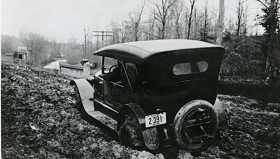
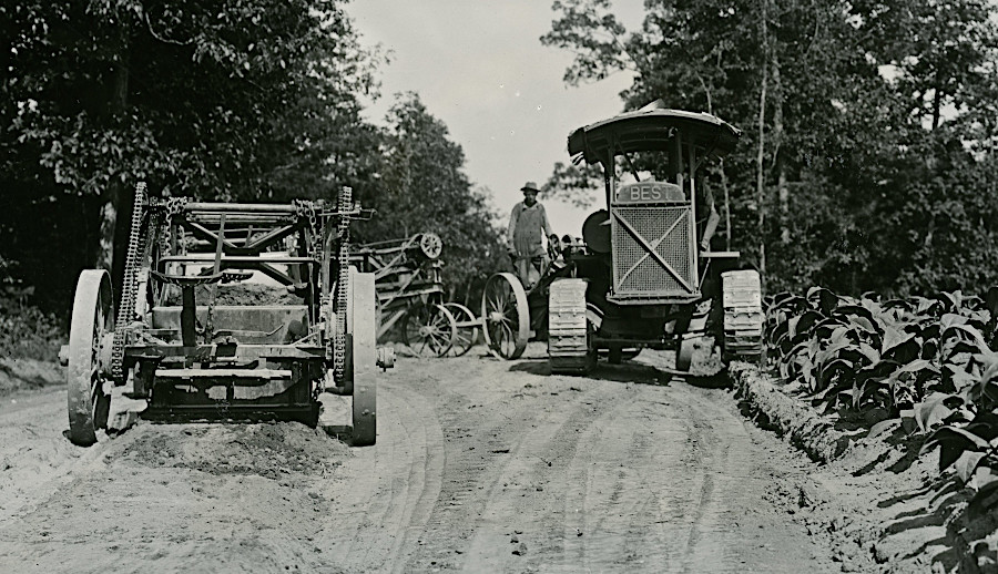
dirt roads were replaced by paved roads, with impervious asphalt/concrete surfaces that prevented the underlying soil from becoming wet slippery mud
Source: National Archives, Washington-Richmond Road Near Quantico (1919) and Short Turn With Five Loaded Scrapers (1929)
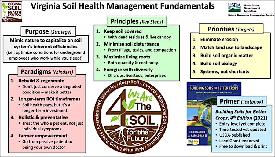
soils can be altered through management techniques to improve suitability for growing crops, supporting buildings, infiltrating water, etc.
Source: National Resources Conservation Service (NRCS), Soil Health Management Recommendations | Virginia