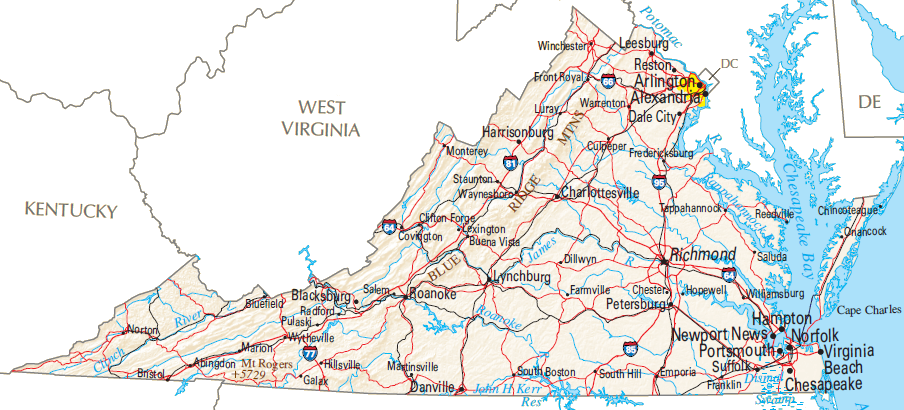
Regions of Virginia
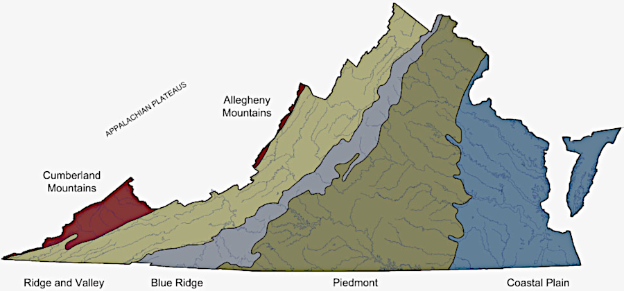
the Virginia Natural Heritage Program defines five physiographic boundaries based on elevation, relief, geomorphology, and lithology
Source: Virginia Department of Conservation and Recreation, Overview of the Physiography and Vegetation of Virginia (p.5)
The Virginia Company received three charters from King James II establishing the company's claim to land in North America. The Second Charter, issued in 1609, extended the grant inland to extend from sea to sea, west and northwest. Based on that grant, Virginia at one time reached across the continent to the Pacific Ocean. It once incorporated far more land with greater variety of characteristics and people than is located within the modern state boundaries.
Virginia was already occupied when the Spanish arrived in 1570 and the English in 1607, and the Native Americans had their own regional cultures. The Native American land claims were extinguished through a variety of techniques, including simple seizure of territory, warfare, treaties, and purchases. There were a few attempts by Native Americans to retain land ownership in certain locations using the colonial legal system, and several reservations were created. Those created for the Nottoway and Gingaskins were extinguished and land sold to non-native owners, but the reservation created for the Pamunkey tribe has survived to the present day (including the component now occupied by the Mattaponi).
Starting in 1620, Virginia's boundaries were reduced by the creation of new colonies, first in Massachusetts, then in Maryland and the Carolinas. During the American Revolution, Virginia voluntarily ceded to the new national government its claims to lands west of the Ohio River. One Virginian, Thomas Jefferson was instrumental in determining how the Northwest Territory would be governed and converted into new states.
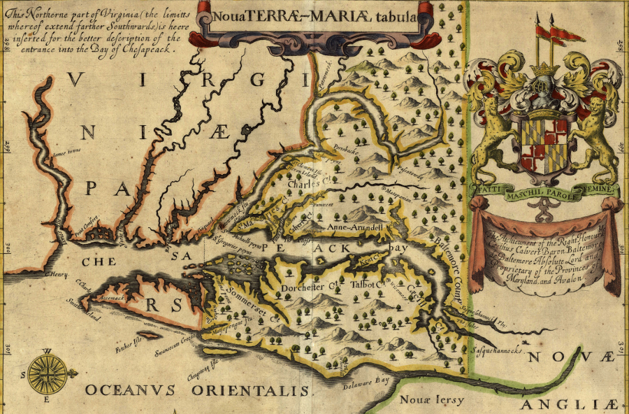
unlike the creation of the Massachusetts Bay Colony, the creation of Maryland blocked Virginians from owning land they had already settled (such as William Claiborne's fur trading station on Kent Island)
Source: Maryland State Archives, John Ogilby, Nova Terrae-Mariae tabula, 1671 (Figure 8)
After adoption of the Constitution, the counties on the far western edge of Virginia were organized as the new state of Kentucky, with Virginia's support. The final loss of territory occurred during the Civil War, when most of the remaining Virginia counties on the Appalachian Plateau formed the new state of West Virginia. The reductions in territory still left Virginia with enough variety in natural and cultural characteristics to classify distinct regions.
Until World War II, Virginians could make an educated guess about a person's original region by observing their distinctive accents, food preferences, and other patterns of behavior. Virginia's regions reflect transportation and population patterns established during the colonial era and prior to the Civil War. Physical geography shaped those patterns, and the modern regions of Virginia are still affected by features such as the Blue Ridge and the James River.
Physiographic regional boundaries are established, but cultural regional boundaries are blurring as radio/television/social media increase interaction at a national level. Today, bagels and Chinese take-out are common in Martinsville as well as Arlington, NASCAR is popular in Warrenton as well as Emporia, and Sunday afternoon football is watched in Grundy as well as Virginia Beach. In 2013, there was a Korean restaurant operating in Pembroke (Giles County) good enough to attract customers from Roanoke...
a flood control project and expansion of US460 relocated downtown Grundy across the Levisa Fork, and a Wal*Mart is now the primary retail outlet in a three-story building that replaced the distinctive old structures
There are still distinctive regional differences between places and people in Virginia today. If you are in a Hardee's in South Boston, notice the iced tea. Odds are, it will be sweetened, unlike the iced tea in the Hardee's at Fredericksburg. The line separating unsweetened vs. sweetened ice tea could be used to define the sections of Virginia more influenced by north culture vs. southern traditions.
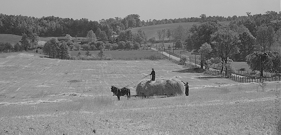
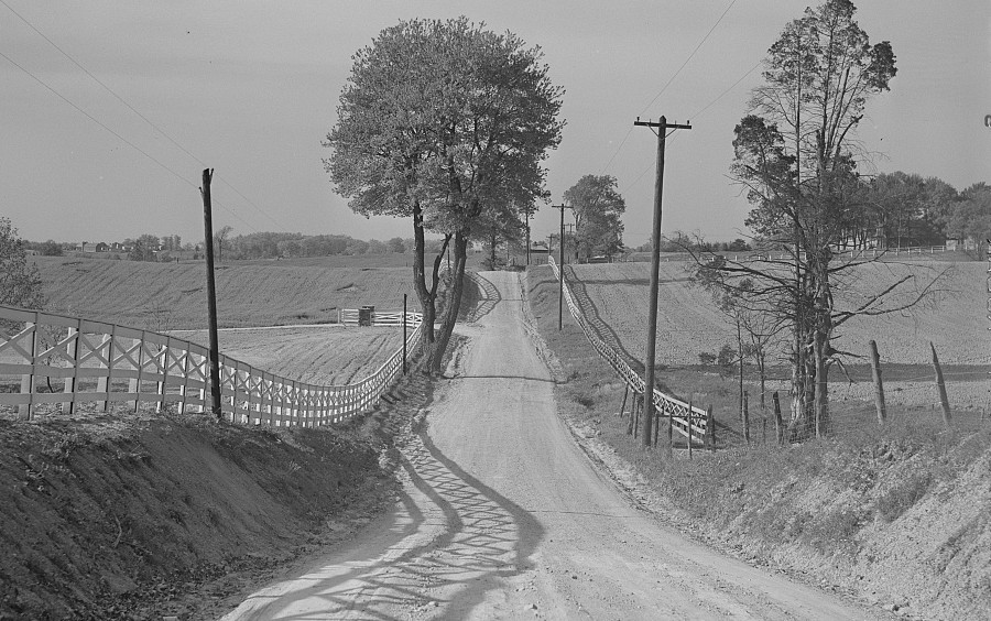
Fairfax County was predominantly agricultural with dirt roads until World War II
Source: Library of Congress, Farmers taking in rye after it had been cut near Vienna, Virginia; Dirt road and fence through farmland in Fairfax County, Virginia (by Marion Post Wolcott, 1941)
Fan preferences for sports teams can also define boundaries. The Washington football team opened a southern training camp in Richmond in 2013, in part to generate more support from that region and peel away old allegiances to teams based in Atlanta - or, more recently, in Charlotte, North Carolina.
In Manassas, high school students track the success of the Virginia Tech football team, but Danville students follow the athletic successes of competing universities in North Carolina. Food and music preferences offer less reliable bases for drawing sectional boundaries (there are excellent Japanese restaurants in Roanoke and Garrison Keillor has presented Prairie Home Companion shows in the coliseum there), but a Middleburg or McLean address will still carry far more social cachet - except in the West End of Richmond, where your family name may carry more weight than even your bank account.
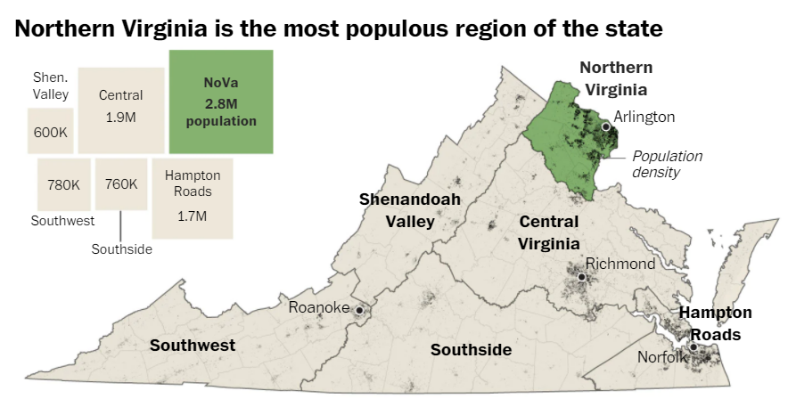
Northern Virginia, as the region with the greatest population, has an outsized influence on the results of statewide elections
Source: Washington Post, Between the GOP and the governor's mansion: A bigger, bluer Northern Virginia (August 7, 2021)
If you have a nostalgic First Family of Virginia (FFV) perspective, you can say there's Northern Virginia and then there's "real Virginia." Typically, folks drawing this line are long-term residents who make humorous references to Northern Virginia as an alien entity, occupied Virginia filled with Northerners and people with no long-term family ties to Virginia.
In the eyes of people living far south of the Rappahannock River, Northern Virginia has been "different" ever since Lord Fairfax established a land office issuing Northern Neck deeds independently from the colonial government in Williamsburg, or Arlington was incorporated into the District of Columbia between 1800-1847.
Referring to "old Virginny" or "real Virginia" may be taken as a quaint, archaic comment when made by an elderly and wistful FFV longing for a simpler past. In the 2008 presidential election campaign, however, Republican surrogates campaigning for John McCain discovered that when non-FFV's make comments about "real Virginia," the comments may be interpreted as a put-down of modern Virginia.1
Why the strong reaction? During massive resistance to school integration/civil rights in the 1950's, advocates of perpetual segregation adopted Confederate symbols and claimed to represent the "real Virginia heritage." Today, references to "real Virginia" may be interpreted as coded language intended not just as a joke, but to express opposition to the multi-cultural diversity that is now common in urban areas and Northern Virginia.
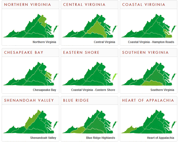
If you are a splitter rather than a lumper, you can segment Virginia into many, smaller cultural regions. For example, the region of Hampton Roads can be split into the Eastern Shore, Gloucester, North Hampton Roads, and South Hampton Roads. Keep splitting, and North Hampton Roads could be split into Williamsburg/York County, Newport News, and Hampton. (Poquoson has its own demographic mix, and might appreciate being omitted...) Based on political patterns, South Hampton Roads could be divided into Suffolk/Sussex/Chesapeake, Norfolk/Portsmouth, and Virginia Beach.
there are multiple interpretations of distinctive cultural regions of Virginia, with inconsistent terms and boundaries
Source: Ray Sterner, Color Landform Atlas of the United States
The US Board on Geographic Names states:2
- Regions are application driven and highly susceptible to perception. Individuals might agree on the core of a region, but agreement deteriorates rapidly outward from that core. The criteria or application would have to be defined, such as physiographic (this would include parts of States, but there is more than one system); political (definite disagreement based upon perception); cultural (unlimited variables); and other applications.
- Geographers apply four generic requirements for a region to be formed: area, boundary (or transition zone), at least one factor of homogeneity or sameness, and a process to drive the region or to keep it functioning as a region. The American National Standards Institute (ANSI) has taken the same approach. Regional definitions applied by any organization reflect their particular needs or application, not a government standard.
the boundaries of megaregions can be define by the pattern of commuters getting from homes to jobs
Source: PLOS One, An Economic Geography of the United States: From Commutes to Megaregions (by Garrett Dash Nelson, Alasdair Rae, 2016)
if you were a Census enumerator, you would try to find every single person in your Census block. However, if you were doing direct mail advertising, you would use Zip Codes to split down further all the way to distinct neighborhoods. If you were a politician, you would split down to precincts - remember, all politics is local. In a get-out-the-vote effort on election day, you would be especially granular. Your campaign would seek out supporters and independents, but try to identify and bypass the individual houses of known opponents.
The boundaries of the regions of Virginia are permeable to migration of people and information. Boundaries may be shown on maps appear as clear lines, but in reality regions are poorly-defined, subject to debate, and likely to be outdated within a few decades.
Loudoun and Prince William became part of Northern Virginia long after Alexandria and Arlington, and as of 2021 Fauquier was not included in most references. It is not clear if Stafford/Fredericksburg will be added to Northern Virginia, or if the megalopolis will have distinct sub-regions. In a decade, cars south of Quantico might sport FXBG stickers to identify more with Fredericksburg than with Fairfax/DC.
In 2021, when the Washington Post assessed the significance of the Northern Virginia region in statewide elections, the newspaper included Fredericksburg and Stafford as part of the region. Nearly 1/3 of all the votes in statewide elections were cast in the 11 jurisdictions of Arlington, Fairfax, Fauquier, Loudoun, Prince William and Stafford counties, plus the cities of Alexandria, Fairfax, Falls Church, Manassas and Manassas Park. The 2.8 million residents in Northern Virginia far exceeded the total in the newspaper's definitions for Central Virginia (1.9 million) and Hampton Roads (1.7 million).3
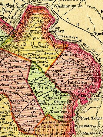
Northern Virginia - 1895
Since 2004, the Council on Virginia's Future has assessed the success/failure of different state-supported initiatives and programs with its "Virginia Report" scorecard, and with other reports posted on the Virginia Performs website. Accounting for the impact of government actions and future trends is presented in a statewide How Is Virginia Doing? assessment, and also in regional perspectives. The boundaries of the regions used by the Council on Virginia's Future do not match the boundaries used by the Weldon Cooper Center at the University of Virginia; even the best analysts and demographers differ in their definitions of Virginia's regions.
the boundaries of every region of Virginia are different between Virginia Performs vs. Weldon Cooper Center
Source: Council on Virginia's Future, Virginia's Eight Regions
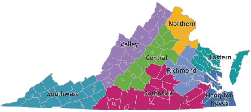
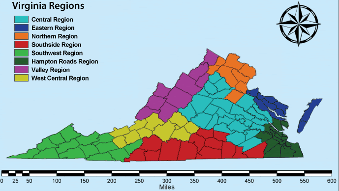
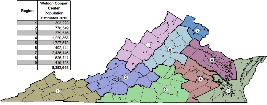
regions of Virginia previously defined by Weldon Cooper Center at University of Virginia
Source: Weldon Cooper Center, Virginia's Regions
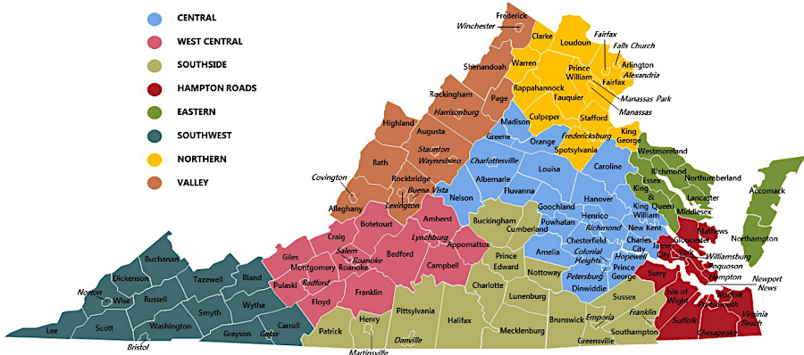
by 2018, the Weldon Cooper Center had defined a West Central Region and altered other regional boundaries
Source: Weldon Cooper Center, Virginia's Demographic Regions
In 2016, the General Assembly created the "GO Virginia" program to stimulate private-sector jobs, recognizing that the Federal government cutbacks would depress economic growth in Northern Virginia and Hampton Roads in particular. The state agreed to provide matching funds to stimulate projects, committing a portion of the increased income taxes generated by the new jobs. Nine regional councils were established to ensure all regions would be able to compete for funding.
Each regional council received some economic development funding, based upon the population within that region. In addition, councils could approve projects sponsored by at least two jurisdictions and submit for competitive grants, which a state board approves.
The primary advocate who convinced the state legislature to create GO Virginia was a Hampton Roads businessman who was frustrated by the parochialism in that region, which was one reason for forcing jurisdictions to partner in order to qualify for funding. The Virginian-Pilot reported:4
- He says "regionalism," by definition, isn't what GO Virginia is doing. It's leveraging cooperation.
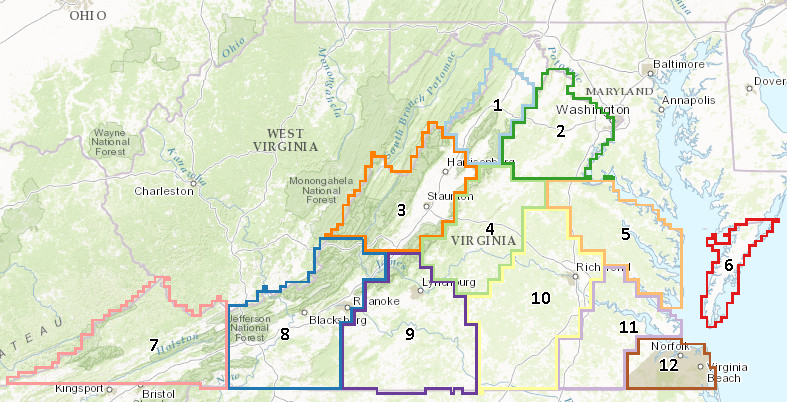
the boundaries of nine Go Virginia regions were defined in 2016
Source: Virginia Department of Housing and Community Development, Virginia Growth and Opportunity Fund
Even Virginia's political boundaries have been subject to change. The colonial claims to the Forks of the Ohio (Pittsburgh area) were dropped in the 1760's. Virginia's claims to the Northwest Territory (Ohio, Indiana, Illinois...) were relinquished in the 1780's. Kentucky became a separate state in the 1790's, and in the 1863 the western 33 counties of Virginia split off to become West Virginia.
George Washington considered the possibility that the United States would collapse, and split between the northern and southern states. If that had occurred, Washington planned to join the northern region.5
The two most distinctive regions of Virginia are Northern Virginia (NOVA) and Rest of Virginia (ROVA). Proposals for creating a separate State of Northern Virginia are not taken seriously today... but maybe tomorrow, sectionalism will spur another secession movement?
Boundaries of the southeastern region, known as Hampton Roads or more recently as Coastal Virginia, are vague. Some people include Williamsburg and Gloucester, while others omit them. Efforts to define other regions also involve changing boundaries.
the state tourism agency defines nine regions of Virginia
Source: Virginia Tourism Corporation, Virginia Map
The Weldon Cooper Center for Public Service at the University of Virginia produces some of the most astute assessments of modern Virginia, but Weldon Cooper placed the city/county of Roanoke in the Valley Region which stretched north to the Potomac River. Montgomery County (including Virginia Tech) was placed in the Southwest Region, extending south to Tennessee while Franklin County was placed in the Southside Region, extending eastward to Surry County.
Bedford County was placed in the Central Region, centered on Richmond. An official with the primary economic development group in Roanoke noted that economic links to the New River Valley and Bedford had been obscured by that classification system, saying:6
- The data just isn't meaningful from a Roanoke perspective... It is really only useful as a contrast between NoVa, Hampton Roads and the balance of the state. There is wide variation within these regions, which aren't really descriptive of anything.
to complete a census on what birds are breeding in Virginia, the Virginia Breeding Bird Atlas breaks the state into 12 blocks
Source: Virginia Breeding Bird Atlas
A more granular way to evaluate locations is the Massachusetts Institute of Technology Living Wage Calculator. It estimates the hourly earnings required to pay for basic expenses, in different locations with different costs of living. For Alleghany County in 2014, the number for an individual was $7.49/hour, in Roanoke city and county it was $8.49/hour, while in most of Northern Virginia it was $13.22/hour.7
the boundaries of Metropolitan Planning Organizations (MPO's) define regions with coordinated transportation plans
Source: Federal Highway Administration, HEPGIS
Definition of "region" is also a key part of marketing used by tourism officials. The counties of Highland, Bath, and Alleghany once advertised themselves as "The Alleghany Highlands," but tourists might end up looking at visiting the Alleghany region of Pennsylvania, Maryland, or West Virginia. As described in Highroad Guide to the Virginia Mountains:8
- ...confusion arose. The Allegheny Mountains are a section of the Appalachian Mountains running northwest/southeast along the adjoining borders of Virginia, West Virginia, Pennsylvania, and Maryland. Did the term "Alleghany Highlands" refer to the entire Allegheny Mountain range though the spellings were different?
- Did it mean just Alleghany County, which has the same spelling of "Alleghany"? Or did Alleghany Highlands mean the three western counties of Bath, Highland, and Alleghany most closely associated with the Allegheny Mountains?
The counties have now allied with Craig County, and they market themselves as "Virginia's Western Highlands."
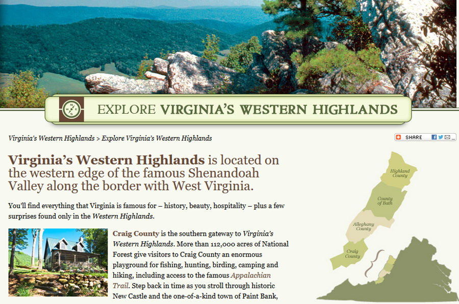
advertising for "Alleghany Highlands" was replaced with "Virginia's Western Highlands"
Source: Virginia Breeding Bird Atlas
Virginia is not a monolithic, uniform place. Regional identity, while not always consistent, is real. Distance between the parts of Virginia is a factor. The Archeological Society of Virginia holds its annual meeting in different locations, and the distance across the state is the primary reason:9
- Did you know that the distance between the Wolf Hills Chapter and the Eastern Shore Chapter is over 400 miles? It is closer for the Wolf Hills folks, headquartered in Abingdon, to go to Indianapolis than Cape Charles.
- It's closer for the Eastern Shore folks, who gather in the southern and central portions of the peninsula, to drive to New York City than Abingdon.
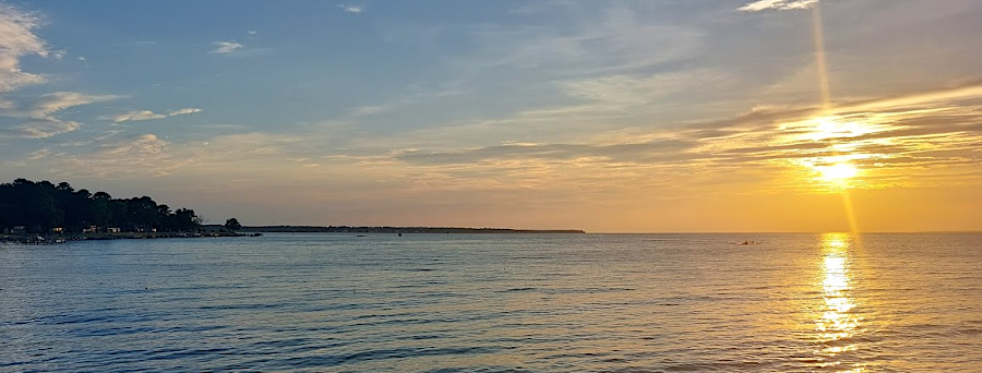
sunset on the Potomac River at Coles Point (Westmoreland County)
The Virginia Museum of History and Culture redesigned its interpretation of Virginia in 2022. In its "Our Commonwealth" exhibit, the museum chose to highlight the heritage of the state through descriptions of five regions - Southwest, Central, Tidewater, Northern Virginia and the Shenandoah Valley. The museum chose not to use the names of "Blue Ridge," "Southside," or "Hampton Roads."10
regions of Virginia, as defined by the Virginia Division of Historic Landmarks in 1985
Source: Reconnaissance Survey of the City of Chesapeake (after p.34)
After a political dispute in 2024, the General Assembly blocked a proposal by Governor Glenn Youngkin to help fund a $2 billion sports complex in Alexandria which would have become the new home of two sport teams. The Wizards and Capitals ended up renewing their commitment to the Capitals Center in Washington, DC.
The chair of the Finance and Appropriations Committee in the State Senate, Sen. Louise Lucas, was from Portsmouth. She personally blocked the state's involvement, in part because of competing regional priorities. The Majority Leader in the State Senate was from northern Virginia and he endorsed state support for a new sports arena; his region would benefit. However, no funding was provided in the proposal to reduce tolls on the Midtown and Downtown tunnels between Portsmouth and Norfolk; Hampton Roads would receive no direct benefits.
The owner of the sports teams blamed political rivalries for the failure to close a deal, but associated the power of the General Assembly opposition with Northern Virginia when he said:11
- Virginia's kind of two states. It's Richmond and Northern Virginia, and they need to, like, get together.
A commentary in a Richmond newspaper took issue with that statement:12
- Virginia is not two states, at least from a Richmonder's perspective. It's at least six: Richmond, NoVa, Hampton Roads, Charlottesville, Roanoke and whatever the hell is west of Roanoke.
That comment triggered a response from the editor of a newspaper focused on Southwest Virginia. It noted:13
- ...there are a lot more than six parts of Virginia. I notice the Shenandoah Valley and Southside didn't make that list, either. Or Lynchburg. Or... well, let's not go down that rabbit hole...
- We have more college students than anywhere else in Virginia... "Whatever the hell is west of Roanoke" is basically the largest concentration of college students in the state.
In 1998, a candidate for a US Senate seat described Charlottesville as being in Southwest Virginia. He lost.
The perception of Virginia as being divided into two halves was repeated in 2024 by the Republican Party candidate for a US Senate seat. Hung Cao, who lived in Loudoun County, had previously declined to drive to Abingdon for a campaign forum, saying the distance made the trip "ridonkulous." He also referred to a newspaper in Staunton as "podunk."
After winning the nomination for a statewide office, he said:14
- Well, President Trump is loved in Southern Virginia. When I say Southern Virginia, I'm talking about Rappahannock, Prince William and Fauquier counties down. That's not very deep. That's an hour out of D.C. And everybody loves him down there. And that's why he's gonna carry the day in Virginia. I'm gonna be there with him.
In response, the Democratic chair of the Finance and Appropriations in the State Senate posted "Hung Cao's Virginia" map on social media:15
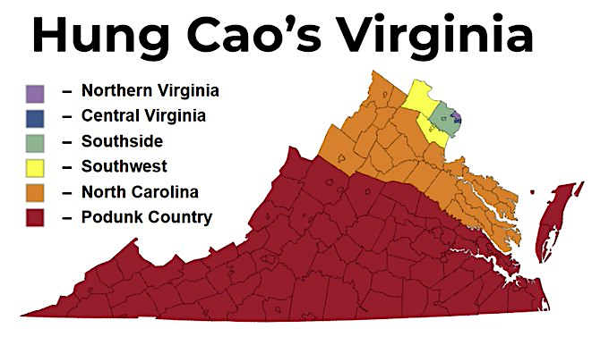
a political candidate's claim in 2024 that Prince William County was in Southern Virginia drew mocking responses
Source: X, Louise Lucas (July 17, 2024 post)
In 2021, the Virginia Supreme Court hired two special masters to redraw boundaries for US House of Representatives districts. The commission responsible for redistricting after the 2020 census had failed to agree on new boundaries, so the court was responsible for the final decision.
The special masters also divided Virginia into two parts, with the Blue Ridge as the feature separating them. The special masters were also tasked with taking into account "communities of interest." Their report to the judges included:16
- In particular, we were mindful of the Blue Ridge Mountains as an important geographic divider in Virginia's history. We also considered the course of the Shenandoah Valley (served
largely by I-81), the federal definition of Appalachia, the historic importance of Southside Virginia and the Piedmont region in general and the Fall Line as important geographic markers.
We also were mindful of the Commonwealth’s major metropolitan areas and the travel arteries that feed them: Northern Virginia, greater Richmond, and the Hampton Roads area, as defined
both by the United States Census Bureau and major media markets.
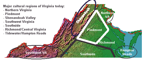
Major Cultural Regions of Virginia
where would you draw the lines, to define regions of Virginia?
Source: US Geological Survey (USGS), Reference and Outline Maps of the United States - Reference Map
Links
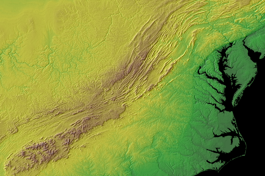
natural features such as the Fall Line, Blue Ridge and Appalachian Plateau, partially explain the development of political boundaries and different cultural regions in Virginia
Source: National Oceanic and Atmospheric Administration (NOAA), Global Land One-km Base Elevation Project (GLOBE) database, Conterminous 48 USA states
References
1. "McCain Adviser Suggests NoVa Not 'Real Virginia'," Washington Post, October 18, 2008, http://voices.washingtonpost.com/44/2008/10/18/mccain_adviser_suggests_nova_n.html (last checked August 6, 2014)
2. "How Do I?," US Board on Geographic Names, https://www.usgs.gov/core-science-systems/ngp/board-on-geographic-names/how-do-i (last checked May 1, 2019)
3. "Between the GOP and the governor's mansion: A bigger, bluer Northern Virginia," Washington Post, August 7, 2021, https://www.washingtonpost.com/dc-md-va/2021/08/07/northern-virginia-governor-elections-republican/ (last checked October 19, 2021)
4. "Hampton Roads has tried to work together before. Will it work this time?," The Virginian-Pilot, March 25, 2017, http://pilotonline.com/business/jobs/hampton-roads-has-tried-to-work-together-before-will-it/article_a1765f91-4176-5e57-9012-60c1567a38f9.html (last checked March 26, 2017)
5. Henry Wiencek, "Elusive George Washington quotation," posting on VA-HIST listserver, May 29, 2003, http://listlva.lib.va.us/scripts/wa-libva.exe?A2=ind0305&L=VA-HIST&F=&S=&P=37659 (last checked August 6, 2014)
6. "S.W. Va. poorest and least diverse among state's regions," The Roanoke Times, July 30, 2014, http://www.roanoke.com/news/local/s-w-va-poorest-and-least-diverse-among-state-s/article_9d72d3a9-5da0-53ef-a3b7-2e51a2fbde5a.html (last checked August 6, 2014)
7. "Living Wage Calculator - Virginia," Massachusetts Institute of Technology (MIT), http://livingwage.mit.edu/states/51/locations (last checked August 6, 2014)
8. Deane and Garvey Winegar, Highroad Guide to the Virginia Mountains, http://www.sherpaguides.com/virginia/mountains/valley_ridge_II/western_highlands.html (last checked August 23, 2017)
9. "Thoughts On Why We Move The Annual Meeting Around The State," The ASV- Newsletter of the Archeological Society of Virginia, Archeological Society of Virginia, September 2017, Number 226, p.1
10. "Editorial: Virginia's oldest cultural organization gets a fresh look," Richmond Times-Dispatch, April 5, 2022, https://richmond.com/opinion/editorial/editorial-virginias-oldest-cultural-organization-gets-a-fresh-look/article_100f09f1-5efb-58b8-b940-6589648ecb43.html (last checked April 5, 2022)
11. "Washington Wizards, Capitals to stay in D.C., abandoning Alexandria arena," Virginia Public Media, March 27, 2024, https://www.vpm.org/news/2024-03-27/alexandria-arena-negotiations-end-nhl-nba-washington-wizards-capitals (last checked April 3, 2024)
12. "Wizards and Capitals owner Ted Leonsis is trash-talking Richmond," Axios Richmond, April 1, 2024, https://www.axios.com/local/richmond/2024/04/01/nova-arena-deal-wizards-capitals-owner-ted-leonsis (last checked April 3, 2024)
13. "'Whatever the hell is west of Roanoke.' Them's fighting words!," Cardinal News, April 3, 2024, https://cardinalnews.org/2024/04/03/whatever-the-hell-is-west-of-roanoke-thems-fighting-words/ (last checked April 3, 2024)
14. "Senate candidate Cao says that anything south of Loudon and Fairfax is 'Southern Virginia'," Cardinal News, July 19, 2024, https://cardinalnews.org/2024/07/19/senate-candidate-cao-says-that-anything-south-of-loudon-and-fairfax-is-southern-virginia/ (last checked July 19, 2024)
15. post on X by State Senator Louise Lucas, July 17, 2024, https://x.com/SenLouiseLucas/status/1813694661149548832 (last checked July 19, 2024)
16. "Current congressional map follows mountains. The proposed one doesn’t. Should that matter?," Cardinal News, March 20, 2026, https://cardinalnews.org/2026/03/20/current-congressional-map-follows-mountains-the-proposed-one-doesnt-should-that-matter/; Bernard Grofman, Sean Trende, "Memo to The Chief Justice and Justices of the Supreme Court of Virginia," December 7, 2021, https://www.vacourts.gov/static/courts/scv/districting/memorandum_re_va_redistricting_2021.pdf (last checked March 20, 2026)
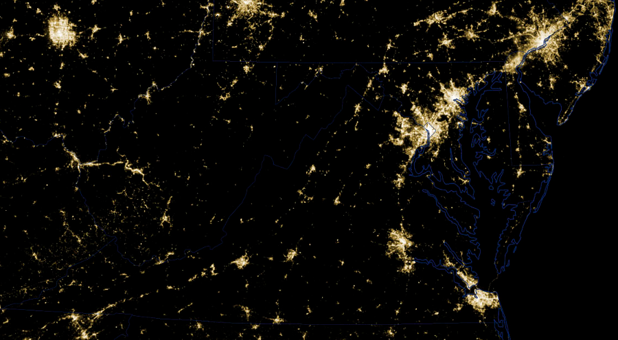
urbanized areas of Virginia with relatively-dense development can be identified by looking at the pattern of lights at night
Source: National Aeronautics and Space Administration (NASA), Earth Observatory, Power Outages in Washington, DC Area
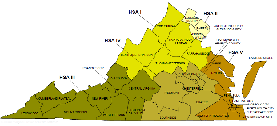
the boundaries of the five Health Service Areas defined where the Virginia Pharmacy Board would approve permits for five cannabidoil processing facilities in 2018
Source: Virginia Department of Health, Health Districts and Health Service Areas, Commonwealth of Virginia
Virginia Places