What Determines the Boundaries of a Region in Virginia?
If you're a "lumper," you could classify the state of Virginia as one state and ignore the different regions within it.
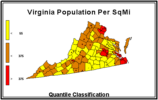
If you care only about one characteristic, such as population density, you could divide the state into three categories based on population density (people
per square mile):
Hmmm... would you label them dense, average, and empty?
Or urban, suburban, and rural? Take advantage of the software and create your own map.
- Set the interactive mapping tool to map by four equal intervals, to distinguish areas with a density less that
1,850 people square mile or greater than 3,700 people per square mile. Compare the result to the map created by
three quantiles (with the break points for different colors at 55 people/square mile and 375 people per square mile).
Then you'll see the really urban areas in Virginia... as well as how you can use different
types of maps to manipulate the presentation of a "fact" differently.
But if you want to look a little deeper, perhaps to determine where in Virginia you should open a business or build
a highway or plan a vacation, it helps to understand how different parts of Virginia are different - or similar.
What makes a region? Well, lets start with something you already know: what makes a
family? That's not a simple question, whether or not you know genealogy, but you can
answer it.
- Do you define your family to include just those of you related by blood, or do you count the
in-laws too? And how about the cousins who live in Canada? Is your family not just the
relatives, but also the close friends from school, work, your religious society - even the
neighborhood? Can you choose your family, as well be born into it?
- You can draw the lines for your family however you wish, but you know others might draw
them differently. You also know that the family lines might change over time, too. In today's
society, split and blended families are created routinely by divorce and remarriage.
So what criteria do you use to define regional (as opposed to family) boundaries? Consider
defining the edges of a region to include that territory where the following characteristics are
more similar than different, more homogenous than distinct:
- geology
- does the area belong to the same physiographic province?
- are the bedrock and the soils comparable within the area?
- are there physical barriers blocking travel outside of (but not within) the region?
- are the mineral resources suitable for development (coal, for example) similar throughout the
region?
- watershed
- do the communities share the same water sources?
- are the pollutants generated within the region dumped into the same rivers?
- ecosystem
- is the region heavily forested, open grassland, wetland/beach, farmland, or urbanized? or is
there a distinct shift in vegetation somewhere within the region
- are the animal populations evenly distributed, so a human would be as likely to see a deer (or
starling) anywhere within the region... or is there a distinct boundary where the critters change
- economy
- do communities within the region create similar products
- are the same natural resources required to manufacture comparable products in different
comunities
- are similar educational or technical skills required to create services
- do comparable jobs within the region pay the same wages
- transportation
- do rivers, roads, and railroads facilitate travel within the region
- do cities and towns within the region use the same transportation corridors to ship products
to areas outside the region
- do workers travel to employment centers within the region
- politics
- are certain political issues or patterns consistent within the region
- are the communities within one House of Representatives voting district
- do communities in the region elect officials with similar voting patterns
- have political units combined into a council of governments, planning district, or
transportation district
- is the population density similar for all political units in the region
- culture
- do people within the same region share common preferences for music, entertainment, and
sports
- do media outlets serve primarily communities within the region
Obviously there are many more... One way to test whether you have drawn a reliable regional
boundary is to draw a transect across the area in question. Look at the statistical reports available
for the political units you cross, and see if there is a distinct break somewhere on the transect.
For example, a transect might show where Hampton Roads fades into Southside, or Northern
Virginia into the Piedmont. In addition to the interstates, other highways make excellent
transects, including:
- Route 58 paralleling the North Carolina border from the Atlantic Ocean to Cumberland Gap
- Route 29 from Arlington to Danville
- Route 15 from the Potomac River to the Roanoke River
- Route 17 from Winchester to the Dismal Swamp
- Route 360 from the Northern Neck to Danville
- Route 460 from Norfolk to Grundy
- Route 60 from First Landing State Park to Batlick Mountain on the West Virginia border
Virginia Places