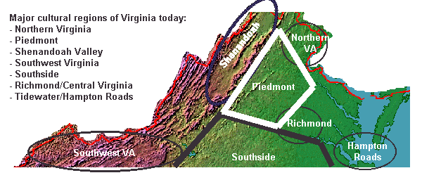
Different Ways to Classify Virginia's Current Regions
|
Virginia is not homogenous - not yet.
Despite the impact of radio, television, and now the Internet, and despite the proliferation of national chains like K-Mart and McDonalds, there are still distinctions between the people in different sections of Virginia. Virginia evolved in fits and starts, and is now a mosaic of different "spaces" that together compose the Commonwealth of Virginia as we know it today.
There are regional nicknames and marketing initiatives to establish a brand for sections of the state, such as "Virginia's River Country" and "Virginia’s Gateway Region."
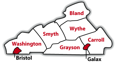
Generic labels allow boundaries to change over time, which was helpful in 2014 when Smyth County withdrew from the economic development partnership labeled "Virginia's aCorridor."1
|
|
There is no guarantee that any two people would agree on the boundaries of these "colloquial" regions:
- Northern Virginia
- is Spotsylvania County or Clarke County included?
- Inside the Beltway
- is Tysons Corner included?
- Shenandoah Valley
- is Rockbridge County included?
- Roanoke Valley
- is Buchanan included?
- Southwest Virginia
- is Roanoke included?
- Southside
- is Southampton County included?
- Hampton Roads
- is Southampton County, Mathews County, or Northampton County included?
|
|
- The Peninsula
- is New Kent County included?
- Middle Peninsula
- is Caroline County included?
- Northern Neck
- is Fredericksburg included?
- Piedmont
- is Franklin County included?
- Blue Ridge
- is Charlottesville included?
- New River Valley
- is Floyd County included?
- Virginia's Heartland
- is any place an appendage rather than heartland?
|
We are now witnessing a revolution in transportation, along with substantial growth in Virginia's population. The physical constraints affecting where people settle are far less important now, and people move between regions easily.
Jobs are also more mobile, so the regional patterns of distinctive cultures and economies are fading. Electricity can be transmitted to any location in the state; locating an manufacturing facility near waterpower is no longer necessary. Highway engineers can tunnel and bridge most every natural barrier, and the Fall Line is irrelevant to international travel by airplane. In a service economy, telecommunications lines reach to every corner of the state. Telephone operators in Norton handle "information, please" inquiries for the entire state. Postal workers in Roanoke read addresses scanned in Fairfax's Merrifield post office, adding a machine-readable bar code to speed sorting and delivery.
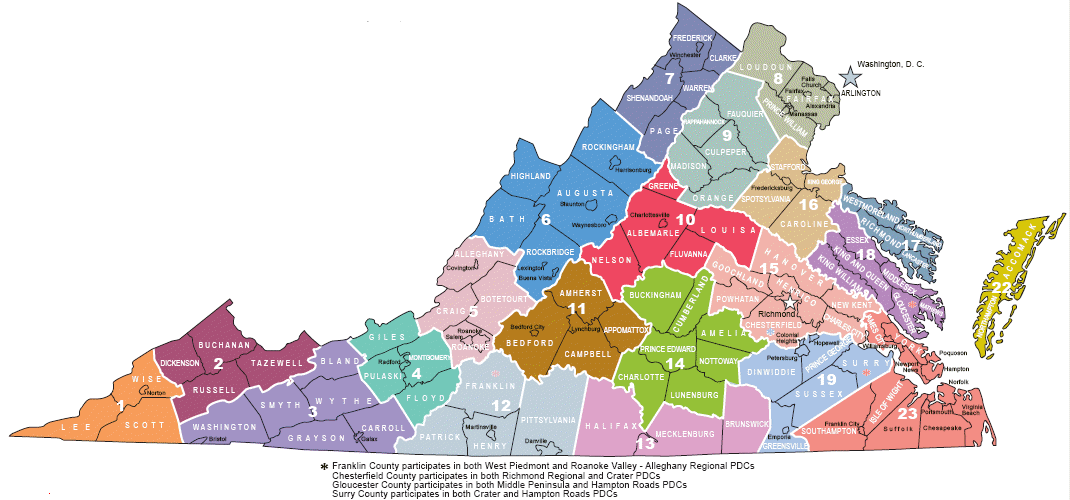
In addition to the physiographic regions of Virginia, another way to carve up the state is to draw regional boundaries based on planning districts, as in The Nine Regions of Virginia by Jim Fonseca. He identified nine distinctive subunits of the state based on their shared interests. His 1990 definitions still have value, but there are other ways to define the current regional boundaries, as shown by these various organizations:
Of course, you can make up your own personal map as well, such as:
If we understand how Virginia's current cultural regions evolved, and calculate the factors that are changing our society now, we can estimate how Virginia's cultural regions will evolve over the next 20 years. However you draw the line, for administrative purposes or for attracting tourists, the state's cultural regions share common characteristics that distinguish them in some way from other areas.
References
1. "Smyth County withdraws from aCorridor," Smyth County News & Messenger, December 16, 2014, http://www.swvatoday.com/news/smyth_county/article_f93d4304-8255-11e4-8109-eb610806b692.html (last checked December 16, 2014)
Regions of Virginia - and Why Isn't There An East Virginia?
Virginia Places