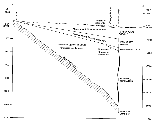
how bedrock dips underneath the Coastal Plain, between Fall Line and Atlantic Ocean
Source: US Geological Survey,
Professional Paper 1404-C: Hydrogeologic Framework of the Virginia Coastal Plain (Figure 5)
how bedrock dips underneath the Coastal Plain, between Fall Line and Atlantic Ocean
Source: US Geological Survey,
Professional Paper 1404-C: Hydrogeologic Framework of the Virginia Coastal Plain (Figure 5)
The Eastern Shore is part of the Coastal Plain physiographic province. Sediments have been deposited on the plain over the last 225 million years as the Appalachian Mountains and Piedmont have eroded, and during periods of higher sea levels when marine sediments accumulated on what today is dry land.
What remains today underneath the Eastern Shore are layers of unconsolidated sediments, deposited mostly since the Cretaceous Period. They are over 6,000 feet thick underneath the Eastern Shore, easy to drill through because they are not compacted into solid rock. The soil at the surface is the basis for agriculture. Sediments below the surface offer little economic value other than for construction fill material, but the groundwater within those deep sediments is highly valued.1
On the flat Eastern Shore, the option of damming a creek and building a reservoir to provide water for municipal or industrial use is minimal. There are only 16 named ponds/reservoirs/lakes in Accomack County and just 14 in Northampton County, according to the US Geological Survey (USGS) Geographic Names Information System - though over 300 small farm ponds that supply irrigation water are not officially named on the USGS topographic maps.2
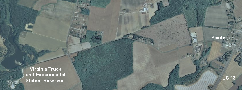
Virginia Truck and Experimental Station Reservoir (Accomack County)
Source: US Geological Survey National Map
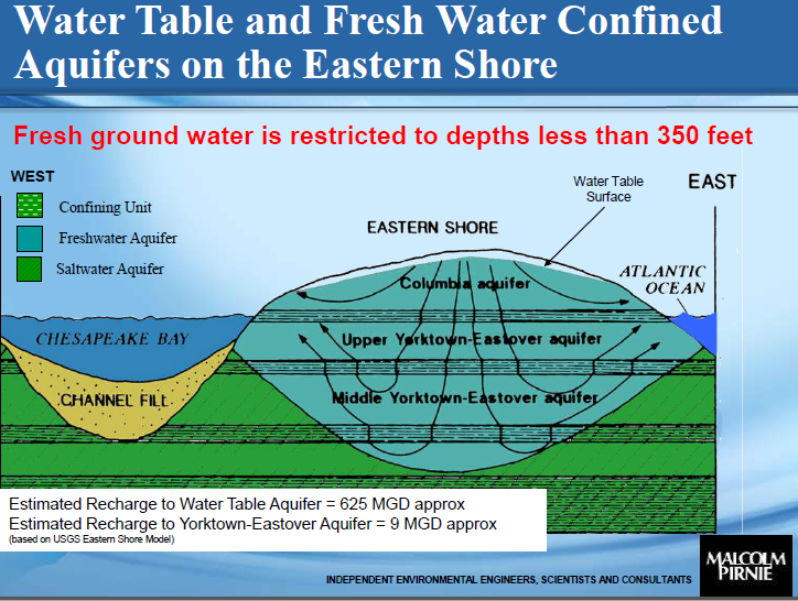
All household drinking water wells on the Eastern Shore (Accomack and Northampton counties) use groundwater as the source. The water table is in the Columbia aquifer. The Yorktown-Eastover aquifer is tapped for municipal drinking water wells.5
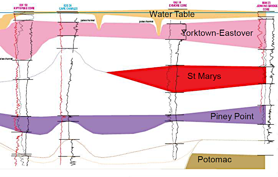
wells on the Eastern Shore wxtract freshwater from the Columbia acquifer ("water table") and the Yorktown-Eastover aquifer
Source: Britt McMillan, Malcolm Pirnie, Inc., Our Eastern Shore Groundwater
Part I: Where is the groundwater and how much is there?
Wells supply water both to individual houses and to communities, such as the Town of Cape Charles. Using authority in the safe Drinking Water Act, in 1997 the US Environmental Protection Agency (EPA) designated groundwater on the Eastern Shore (but excluding Chincoteague and Tangier islands) as a Sole Source Aquifer, because there are no significant fresh water streams on the surface to provide an alternative supply. Designation means that projects involving Federal funds, and which have the potential to contaminate the aquifer, must be reviewed by EPA.3
Wells are drilled to intercept water-saturated regions of underground sandy sediments, known as aquifers. Different aquifers are separated from each other by impervious layers of clay known as confining units.
On the Eastern Shore, the deeper Yorktown-Eastover aquifer system, in sediments deposited during the Miocene Epoch 5-23 million years ago, is the preferred source for municipal drinking water. The shallower Columbia aquifer, in sediments deposited during the Pleistocene 10-15,000 years ago, is more vulnerable to contamination from septic systems, fertilizer nitrates, and pesticides/herbicides used on local farms. Wells drilled into the Columbia aquifer do provide irrigation water for agricultural use as well as water for individual houses, but the aquifer protection priority is clear:4
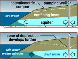
saltwater intrusion
Source: US Geological Survey, Southern California Salt-Water Intrusion
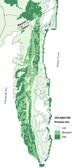
Primary recharge of the groundwater occurs along the spine of the Eastern Shore, the high ground traced by the US 13 highway. Though most rain will run off the highway, rooftops, and farm fields into ditches and flow towards either the bay or ocean, some rain will seep underground. In the summer, much of that underground water is sucked up by plant roots and evapo-transpired into the atmosphere, but in winter a higher percentage on rainwater will remain underground.
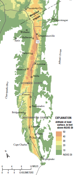
only a small portion of the Eastern Shore exceeds 50 feet in elevation
Source: US Geological Survey, Simulation of Groundwater-Level and
Salinity Changes
in the Eastern Shore, Virginia (Figure 2)
Near Chincoteague, rainwater may travel 500 feet-5 miles underground. A raindrop could spend as much as 30-300 years underground, if it took a deep journey through the Columbia aquifer before discharge at the surface. The confining layers separating aquifers allow some flow of water at depth, but the deeper the aquifer the older the water within it.
In the upper portion of the confined Yorktown-Eastover aquifer, groundwater is 300 to 3,000 years old. In the middle portion, water is estimated to have been buried underground for 1,000-10,000 years. The lowest part of the Yorktown-Eastover aquifer, the water could have been underground for 10,000-30,000 years.
Most raindrops spend only a few months or years underground. In Accomack County, 80% of the water flowing in the 30 creeks in the county is groundwater that seeped to the surface. About 10% of the rain that falls on the surface (4-5"of the 44 inches/year of rainfall) will recharge the Columbia aquifer each year, while just 0.05 inches/year will seep further down to recharge the Yorktown-Eastover aquifer.6
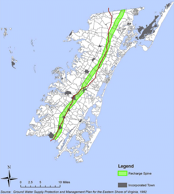
groundwater recharge area for Yorktown-Eastover aquifer in Accomack County (red line is US 13)
(rainfall landing east or west of "spine" soaks into Columbia aquifer, then flows to Chesapeake Bay/Atlantic Ocean)
Source: Accomack County, Draft Comprehensive Plan Update - 2007
The raindrops can carry underground whatever they dissolved in the atmosphere (such as sulfate ions) or on the land surface (such as oil drips from automobiles), potentially altering the quality of the groundwater. Companies that pump out septic tanks in Accomack County used to dump the waste into unlined lagoons, allowing leachate from untreated human waste to seep into the groundwater.
Nitrates from failed septic systems, or a leak in the leachate collection system for the wastewater treatment plant on Assawoman Creek, can still pollute surface streams and groundwater. The Town of Chicoteague has to pipe water five miles from wells at the NASA facility on Wallops Island, because the island's own groundwater has been polluted by septic systems and brackish water intrusion.7
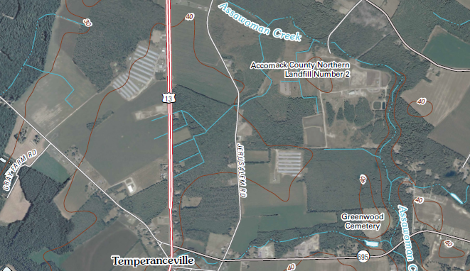
location of North Landfill, Accomack County
Source: US Geological Survey Hallwood topographic map
Underneath the surface in Accomack and Northampton counties, freshwater "floats" in a layer about 350 feet deep on top of saltwater, which is slightly more dense than freshwater. At greater depth, the pores between the rock particles in aquifers are filled with seawater that is too saline for human use. If pressure is reduced by pumping freshwater faster than it is recharged from the surface (similar to sucking fast on a milkshake through a straw), a "cone of depression" forms as pressure drops near the well and saltwater squeezes in from the sides and below in the aquifers.
groundwater aquifers supply drinking water on Eastern Shore
Source: Our Eastern Shore Groundwater: Part I - Where is the groundwater and how much is there?
On the southern tip of the Eastern Shore, groundwater supply and quality are affected by a rare geologic phenomenon. A meteor/comet ("bolide") crashed into the Atlantic Ocean off the shoreline of Virginia 35 million years ago, cracking through all the layers of sediment and even into the crystalline basement. The heat of impact vaporized much of the water, creating a hypersaline pool (50% saltier than seawater) that was trapped as debris refilled the crater, creating an inland salt-water wedge that limits access to usable groundwater between the Eastern Shore and Newport News.8
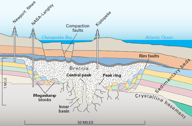
crater from bolide impact 35 million years ago still affects quality of groundwater in Eastern Shore and Hampton Roads
Source: US Geological Survey, Groundwater-Quality Data and Regional Trends in the Virginia Coastal Plain, 1906-2007 (Plate 9)
Agricultural or industrial operations on the Eastern Shore, including large chicken processing factories, could deplete an aquifer faster than it is replenished by rainfall seeping underground. In 1976, the Virginia Department of Environmental Quality (DEQ) designated the Eastern Shore as a Ground Water Management Area, requiring a permit for withdrawals exceeding 300,000 gallons per month.
Groundwater is a renewable resource - but excessive pumping could result in saltwater intrusion into the aquifers, making the water useless for human or agricultural use. Cape May, New Jersey was forced to built an expensive desalination system in 1998, after saltwater contaminated the municipal wells.
By 2010, withdrawals from the Yorktown-Eastover Aquifer exceeded recharge by roughly 1 million gallons/day. Perdue Farms and Tysons Food pumped more groundwater than any other users on the Eastern Shore. In Accomack County, 66% of groundwater permits were for agricultural operations. In Northampton County, 75% of groundwater permits were for agriculture.9
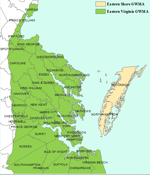
the Eastern Shore is one of two Ground Water Management Areas in Virginia
Source: Virginia Department of Environmental Quality, Detailed Map of Groundwater Management Areas
According to a groundwater specialist discussing the long-term sustainability of pumping water from the Yorktown Formation for municipal use:10
In 2009 the Virginia Department of Environmental Quality began to pressure permittees in the Eastern Virginia Groundwater Management Area to shift from the deep, confined Yorktown-Eastover aquifer to surface aquifers recharged more readily by rainfall. The state agency reduced the amount of water authorized for extraction, which at the time affected primarily two large paper mills.
Later, large poultry farms developed on the Eastern Shore. Those raising about 100,000 chickens used enough water to require obtaining a groundwater withdrawal permit from the Virginia Department of Environmental Quality (DEQ). After an investigation of unauthorized use, in 2017 the state agency issued consent orders to 56 poultry facilities that agreed to comply with the regulations. At the time, some of the wells depleting the deep aquifer were getting close to reaching the "critical surface" at which only 20% of the aquifer depth was still remaining.
Five operations reduced their use below the 300,000 gallons per month threshold that required a permit. In 2019, the State Water Control Board directed 45 poultry operations on the Eastern Shore to consider using the Columbia aquifer as part of their final permits, with six more permits still being processed that would include similar direction. The State Water Control Board did not et any deadline for shifting to the shallow Columbia aquifer.
The 2020 the General Assembly passed a law restricting wells in groundwater management areas. New wells drilled for nonagricultural irrigation purposes could only pump from the surficial aquifer. To incentivize existing users of the Yorktown-Eastover aquifer to shift to the Columbia aquifer, the State Water Control Board modified its permits in 2021. Sits using the surface aquifers could be authorized for 15 years under a general permit, while sites using the Yorktown-Eastover aquifer were required to obtain an individual permit at greater expense.
The Chesapeake Bay Foundation supported the "carrot and stick" approach used by state agencies to reduce demand on the deep aquifer. A spokesperson commented:11
soils and slopes determine how much fresh water seeps underground to recharge aquifers on the Eastern Shore
Source: US Geological Survey, Simulation of Groundwater-Level and Salinity Changes in the Eastern Shore, Virginia (Figure 22)
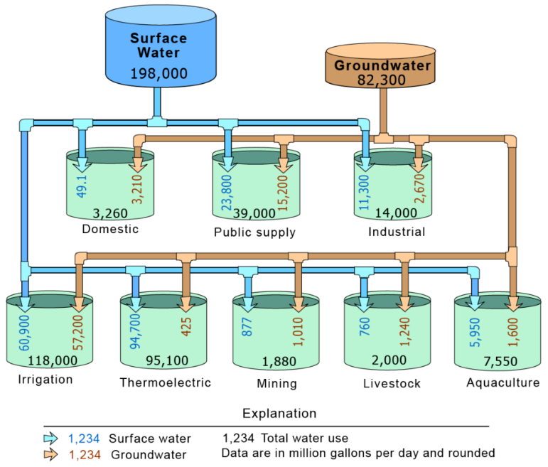
nationwide, most groundwater is used for irrigation
Source: US Geological Survey, Groundwater Use in the United States
1. Andrew A. Meng III, John F . Harsh, "Hydrogeologic Framework Of The Virginia Coastal Plain," US Geological Survey Professional Paper 1404-C, 1988, p.C7, http://pubs.usgs.gov/pp/pp1404-C/pdf/pp_1404-c.pdf (last checked March 6, 2013)
2. Geographic Names Information System, US Geological Survey, http://geonames.usgs.gov/; "Ground Water Supply Protection and Management Plan for the Eastern Shore of Virginia," Eastern Shore of Virginia Ground Water Committee, 1992, p.2-6 (last checked July 23, 2012)
3. "Permit Review and Tracking," Eastern Shore of Virginia Groundwater Committee, Accomack-Northampton Planning District Commission, http://a-npdc.org/accomack-northampton-planning-district-commission/ground-water-management/projects-programs/permit-review-and-tracking/; "Sole Source Aquifer," Accomack-Northampton Planning District Commission, http://a-npdc.org/accomack-northampton-planning-district-commission/ground-water-management/about-our-groundwater/sole-source-aquifer/; "'Carrot and stick' regulations aim to increase shallow aquifer use," Virginia Mercury, January 17, 2022, https://www.virginiamercury.com/2022/01/17/carrot-and-stick-regulations-aim-to-increase-shallow-aquifer-use/ (last checked January 17, 2022)
4. "Ground Water Supply Protection and Management Plan for the Eastern Shore of Virginia," Eastern Shore of Virginia Ground Water Committee, 1992, p.2-10, p.2-13 (last checked July 23, 2012)
5. Jonathan J. A. Dillow, William S. L. Banks, Michael J. Smigaj, "Ground-Water Quality and Discharge to Chincoteague and Sinepuxent Bays Adjacent to Assateague Island National Seashore, Maryland," US Geological Survey, Water-Resources Investigations Report 02-4029, p.1, http://pubs.usgs.gov/wri/wri024029/wri02-4029.pdf; Ward E. Sanford, Jason P. Pope, and David L. Nelms, "Simulation of Groundwater-Level and Salinity Changes in the Eastern Shore, Virginia," US Geological Survey Scientific Investigations Report 2009-5066, 2009, p.65, http://pubs.usgs.gov/sir/2009/5066/ (last checked July 23, 2012)
6. "Chapter Two: The Natural Environment," 2008 Comprehensive Plan Update, May 14, 2008, p.2-9, http://www.co.accomack.va.us/Planning/Comp%20Plan%20Update/20080514%20Accomack%20Comp%20Plan%20Chap%202.pdf; "Ground water Availability and Resource Protection," February 2009, (last checked July 23, 2012)
7. "Ground Water Supply Protection and Management Plan for the Eastern Shore of Virginia," Eastern Shore of Virginia Ground Water Committee, 1992, p.2-10, p.3-18; Town Of Chincoteague Water Supply Plan, October 4, 2010, p.34, http://chincoteague-va.velopers.net/pdf/overall-Document.pdf (last checked July 23, 2012)
8. "Disruption of Coastal Aquifers" in The Chesapeake Bay Bolide: Modern Consequences of an Ancient Cataclysm, US Geological Survey, http://woodshole.er.usgs.gov/epubs/bolide/aquifers.html (last checked July 23, 2012)
9. "Groundwater Protection and Management Planning for the Eastern Shore of Virginia," presentation by Britt McMillan (Malcolm Pirnie, Inc.), June 2009, http://www.a-npdc.org/groundwater/ES%20gw%20sustainable%20develop%20Jun09.pdf; Ground Water Withdrawal Permitting Program, Virginia Department of Environmental Quality, http://www.deq.state.va.us/Programs/Water/WaterSupplyWaterQuantity/GroundwaterPermitting.aspx; Eastern Shore Of Virginia VDEQ Permitted Groundwater Withdrawals, Eastern Shore Of Virginia Groundwater Committee, 2011, http://a-npdc.org/groundwater/Eastern%20Shore%20Permitted%20GW%20Withdrawals%20Apr11.pdf (last checked July 23, 2012)
10. "Highlights From October 2007 Groundwater Briefing," Chincoteague Reports, October 25, 2007, http://www.chincoteaguereports.com/my_weblog/ground_water/ (last checked July 23, 2012)
11. "SB 673 Nonagricultural irrigation wells; prohibited outside surficial aquifer," Virginia Legislative Information System, 2020 General Session, https://lis.virginia.gov/cgi-bin/legp604.exe?201+sum+SB673; "'Carrot and stick' regulations aim to increase shallow aquifer use," Virginia Mercury, January 17, 2022, https://www.virginiamercury.com/2022/01/17/carrot-and-stick-regulations-aim-to-increase-shallow-aquifer-use/; "Amid chicken farming boom on Eastern Shore, state worries about water supply," Virginia Mercury, December 13, 2019, https://www.virginiamercury.com/2019/12/13/amid-chicken-farming-boom-on-eastern-shore-state-worries-about-water-supply/ (last checked January 17, 2022)