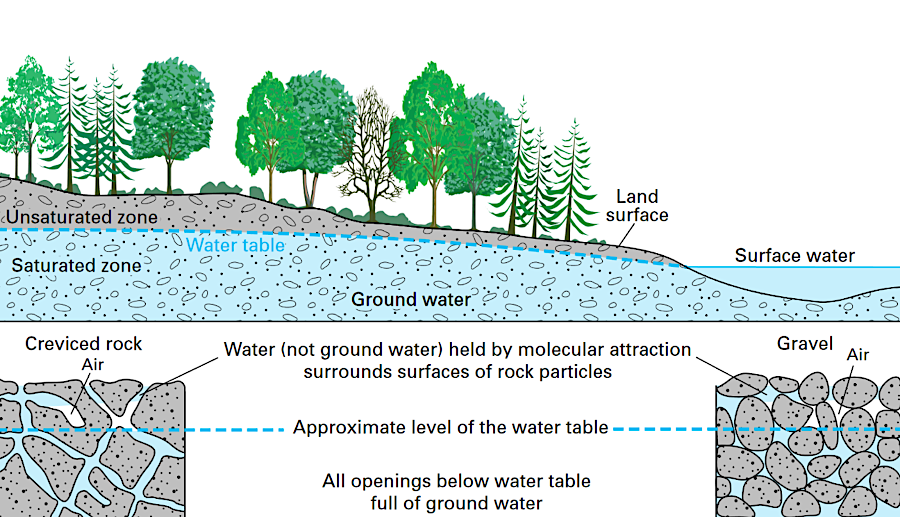
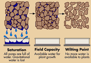
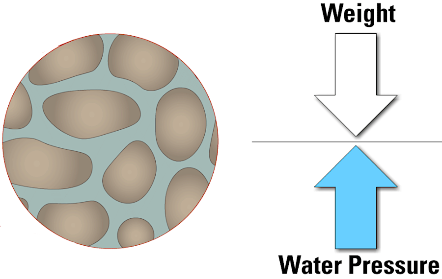
groundwater fills spaces between the pores of rock particles
Source: US Geological Survey (USGS), Aquifers and Groundwater
groundwater fills spaces between the pores of rock particles
Source: US Geological Survey (USGS), Aquifers and Groundwater
When it rains... where does the water go?
Some raindrops are trapped by leaves in the summer, or needles on evergreen conifers in the winter. That water can evaporate back into the atmosphere without ever touching the ground. Other raindrops hit the ground and flow on the surface downhill, ultimately reaching a stream.
In urbanized areas, where pavement and roof tops cover the natural ground surface, raindrops might run down a gutter or off a paved road into a stormwater pond, then drain from the pond's outlet into a creek. Runoff from parking lots occurs even in natural areas, such as state parks.
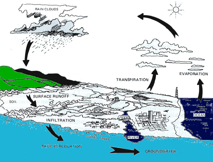
the original source of groundwater: rainfall
Source: Virginia Water Resources Research Center, The Threat to Virginia's Groundwater
When it rains at the marina in Leesylvania State Park, water runs directly from the impervious parking lot asphalt directly into the Potomac River, while much of the rainwater hitting the entrance road (Daniel K. Ludwig Drive) first flows into Powell's Creek before reaching the river. The surface runoff will absorb dirt particles (and fluids that have dripped from cars and trucks), making the roads and parking lots look clean after a storm - but carrying the dissolved pollution downstream towards the Chesapeake Bay.
In undeveloped areas within the park, water hits tree leaves, soaks into the soil, and goes underground. On a hot summer day, the water under the surface may stay only briefly in the pore spaces between soil particles, before evaporating directly back into the atmosphere or indirectly after being sucked into the root system of plants ("evapotranspiration").
Other raindrops may soak deeper into the soil, seeping into the pores the way syrup trickles into a snow cone. Water collects in spaces between soil and rock particles, then migrates underground by gravity through porous sediments and cracks in bedrock. Raindrops that fall in Virginia, and do not evaporate or become captured within plant cells, will eventually flow - above and below ground - into a nearby stream channel. Ultimately groundwater and surface water both end up in the Gulf of Mexico or the Atlantic Ocean.
Virginia soils can retain groundwater for up to two weeks before evapotranspiration in the summer sucks the available moisture out of the soil. Suburban gardeners and farmers across the state are well aware of the days between rains. Though 94% of all freshwater is stored in the ground, its availability for plant growth depends upon the ability of roots to reach it. Most roots are in the top 24"-36" of soil, while most groundwater is below that level.
Evapotranspitation after a series of hot summer days can cause roots to exhaust the supply of groundwater in the accessible soil. As one farmer put it:1
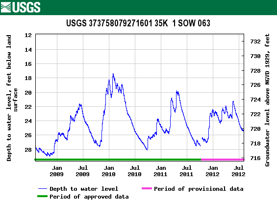
underground, water can accumulate during the winter, but groundwater levels drop during the summer as evapotranspiration peaks
Source: US Geological Survey, Groundwater Watch - Glasgow, Virginia
Thanks to rainfall and melting snow, water regularly seeps into the root zone and below it. Water accumulates in soil and bedrock, becoming groundwater rather than surface runoff. Water accumulating underground does not create a lake or pond; instead, the drops fill up the pores between particles of rock.
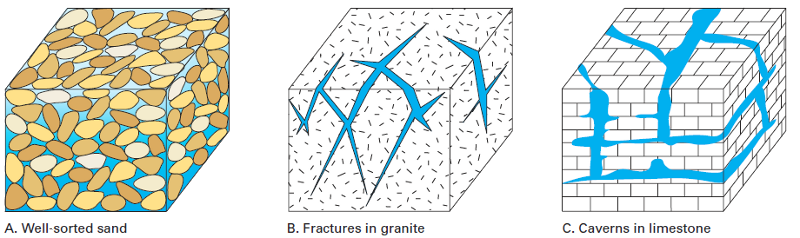
Fractures, porosity, and permeability of different geologic formations varies across Virginia, affecting the "transmissivity" of groundwater moving through bedrock. The recharge rate and the capacity for groundwater storage is low in the crystalline bedrock of the Blue Ridge. Rain and snow encounters few fractures for infiltration and storage; the molecules of bedrock minerals are tightly connected to each other and provide little space for water to move out of the fractures.
Pumps inserted into wells suck water to the surface. That creates a pressure gradient, and molecules of groundwater migrate towards to zone of reduced pressure. Since fractures in the core igneous rock of the Blue Ridge are not wide or well-connected, the amount of water which can get underground and its ability to migrate under pressure is limited.
Homeowners in the Blue Ridge, and government facilities such as the visitor centers on the Blue Ridge Parkway, must drill deep into the bedrock to find multiple fractures to obtain enough water. The Blue Ridge physiographic province is a poor choice for locating an industrial facility which requires a large amount of water, such as a soft drink bottling plant or a data center.
The nearby carbonate formations in the Valley and Ridge province are excellent sources of groundwater. Over the last 300-500 million years, the limestone and dolomite formations have been cracked by tectonic shifts. Rainfall and snow that becomes slightly-acidic as it moves though the soil dissolves the cacium carbonate minerals in former ocean sediments, creating pores and connections between rock particles which offer high permeability.
Commercial caves open for public visits, plus Natural Chimneys, Natural Bridge, and Natural Tunnel, reveal how the dissolving carbonate minerals can create cavities through which groundwater flows. Less obvious to the casual visitor are the sinkholes and "losing" streams (such as Sinking Creek near Blacksburg) where surface water goes underground.
The availability of groundwater has attracted food processing plants to locate near Waynesboro; a Coors brewery was built near Elkton. Industrial wells can extract many thousands of gallons per day from aquifers in the carbonate bedrock.
Those aquifers are recharged by rain/snow falling on top of them, and falling on adjacent land surfaces. Groundwater will flow downhill, going miles away from where it first soaked into the ground. The sandstones in Massanutten Mountain and on either edge of the Shenandoah Valley have enough porosity and permeability (transmissivity) for droplets to flow through them towards the lowest point, the channel of the Shenandoah River or other streams.
The amount of groundwater within a aquifer depends upon the porosity and thickness of the mineral particles. The speed of groundwater flow through aquifers varies, based on the permeability of the geologic formations.
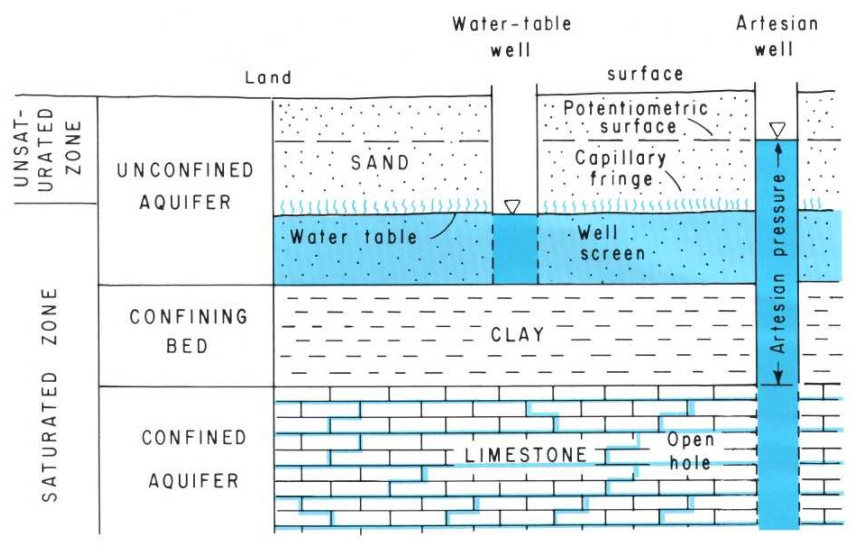
The direction of groundwater flow is consistently downward based on gravity, just like surface flow - except for zones which get pressurized by confining layers. A crack in the cap of such a layer can allow pressurized water to move upwards, creating artesian springs at the surface. Once wells are drilled and the pressure is reduced, artesian flow will stop. At that point, well pumps will be required to pull groundwater up to the surface.
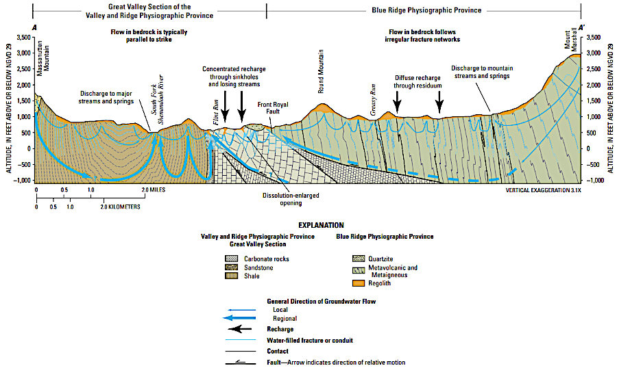
the carbonate formations in the Shenandoah Valley get recharged with water flowing from the crystalline and sedimentary formations on the western edge of the Blue Ridge, plus other sedimentary formations
Source: US Geological Survey (USGS), Preliminary Assessment of the Hydrogeology and Groundwater Availability in the Metamorphic and Siliciclastic Fractured-Rock Aquifer Systems of Warren County, Virginia (Figure 2)
Plant roots obtain water from the voids between soil particles. On hot summer days, the water in those pores evaporates directly to the atmosphere, or indirectly as plant roots suck up the water and transpire it through leaf pores back into the atmosphere.
plants rely upon water trapped between soil particles underground
Source: US Department of Agriculture, Bulletin 462 (republished by Virginia State University)
Rock underground is rarely so solid that there are no pores, and there are normally many connections between pores that make the subsurface permeable. Even igneous rocks typically have fractures or joints through which water can move, though slowly and in limited quantities.
water molecules can be trapped in pores between particles underground
Source: US Geological Survey, Ground Water in Freshwater-Saltwater Environments of the Atlantic Coast (Figure 3)
At Nottoway Park near the Vienna Metro station, the depth to groundwater averages 14 feet. In the Triassic Basin, depth to groundwater at a monitoring well on Bull Run near Route 15 averages 9.35 feet. Since 1968, depth to groundwater at the Bull Run well has ranged from only 6.54 feet in a wet period to 15.54 feet during drought.
Since 1966, depth to groundwater at a monitoring well at Fairy Stone State Park has ranged from 5.98 feet to 27 feet in a dry period. Near Grundy on the Appalachian Plateau, average depth is 19.28 feet.
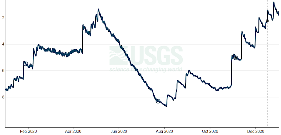
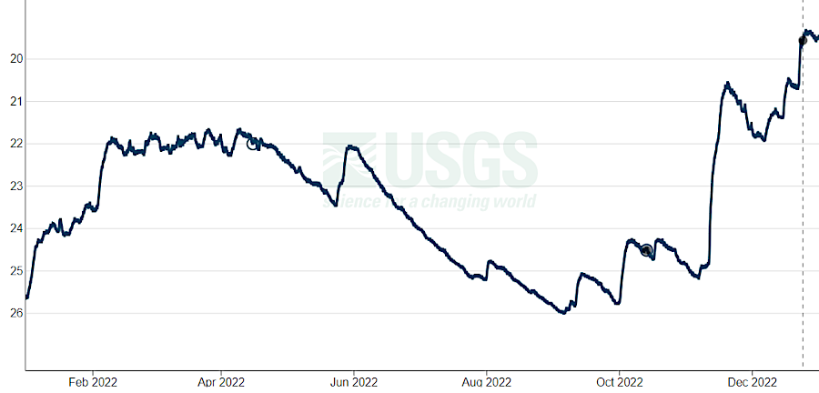
changing depth to the water table in Prince William County in 2020 and Glasgow during 2022 reflects the normal summer drawdown and winter recharge
Source: US Geological Survey, Current Conditions for Virginia: Groundwater, 51S 7 - 383423077245901 and 35K 1 Sow 063 - 373758079271601
Some monitoring wells show much deeper water tables. Near Reedville on the Coastal Plain, a monitoring well showed depths ranging from 55-59 feet. Depth to groundwater at another monitoring well in Accomack County on the Eastern Shore ranged from 71-109 feet.
The deepest hand-dug well in the United States, completed in Kansas in 1888, was 109 feet deep.2
Plant roots are sucking up the water trapped only temporarily in the soil between rains. The groundwater in the completely-saturated zone is much deeper than the vadose zone filled with roots.
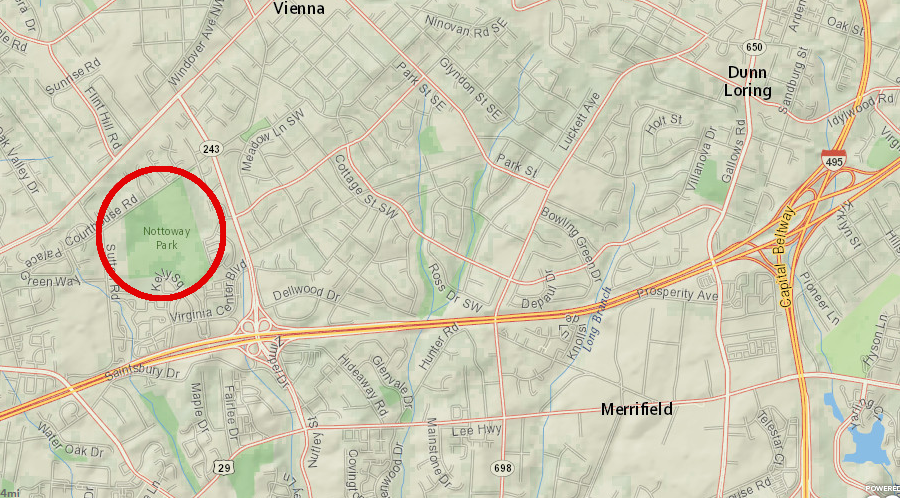
at Nottoway Park, depth to the water table averages 9.35 feet
Source: ESRI, ArcGIS Online
Underneath the Fairfax campus of George Mason University, the metamorphic bedrock has weathered and become a rotted "saprolite" through chemical weathering as feldspars (such as NaAlSi3O8, KAlSi3O8, CaAl2Si2O8) and other minerals have absorbed water and altered to clay. In the Piedmont bedrock of Fairfax County, between Centreville and I-95, the igneous rocks have decomposed to great depth, creating pores between the particles and making it easier to drill a well to the unweathered bedrock.3
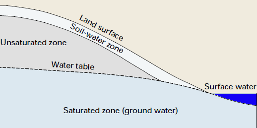
A zone of water-saturated rock is called an aquifer if enough water accumulates underground in the pores between rock particles to supply a natural spring or an artificial water well. Depending upon the rock type, aquifers can absorb and release a lot of water... or just a little.
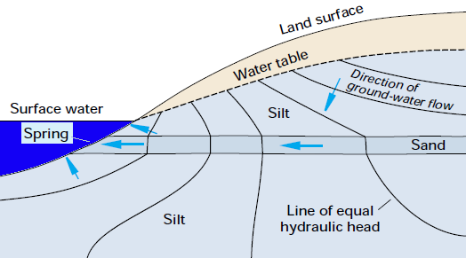
In places where rainfall is sufficient to keep the water table above the water level in a nearby stream, groundwater will seep from the aquifer into the stream. A "gaining stream" is recharged consistently by groundwater flowing from an aquifer into the stream channel.
"Losing streams" appear at places where the water table is below the bottom of a stream. If the stream bottom is not impervious rock, then water will leak from the stream into the aquifer. Streamflow can be reduced to the point where the water disappears, creating "sinking creeks" and "lost rivers" where the channel becomes dry.
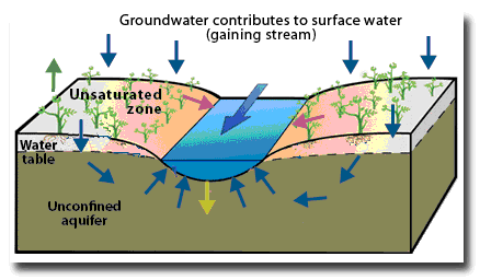
water in aquifers seeps into stream channels which are gaining streams
Source: US Geological Survey (USGS), A gaining stream has water seeping into it from the ground
After a rainstorm in Northern Virginia, the sandstone bedrock west of Centreville (the Mesozoic Basin that formed when the Atlantic Ocean first opened) will absorb substantial water between the grains of sandstone. However, the soil that formed above basalt intrusions in the basin stay relatively dry, because the igneous rock is not very porous. The grains of iron, calcium, and other minerals in the basalt are packed tightly together, without gaps for water molecules. In addition, the basalt has few fractures, so water does not seep into many cracks.
different types of bedrock affect aquifers in Northern Virginia
Source: US Geological Survey, National Atlas
The quality as well as the quantity of groundwater is significant to users. In densely-settled areas such as Virginia's towns and cities, utilities treat raw water so it meets Safe Drinking Water Act standards and then pipe drinking-quality water to customers.
Most people living rural areas, away from water and sewer services provided in urban/suburban areas, drill individual wells to obtain drinking water for widely-separated houses. Houses dependent upon an individual well rarely treat the water, except to replace calcium with sodium (salt is used to soften the water, reducing its "hardness") and occasionally to remove excessive dissolved iron.
For water quality purposes, water wells supplying drinking water to rural houses are sealed (cased) for the top 30 or so feet. An iron pipe inserted into the well is not perforated in the top 30 feet, blocking the surface water with its load of dissolved fertilizer, dog poop, oil from cars, etc. from entering the well. Drinking water wells must also be located a certain distance away from septic tanks, where human waste flushed away from rural homes is converted by bacteria into harmless gases and fluids.
Most water seeping into drinking water wells for individual houses comes from rain that fell relatively recently. Even if isolated from a leach field, the rainwater carries contaminants from the sky and the surface into the well. A study in 2025 identified per- and polyfluoroalkyl substances (PFAS) in 100% of the 300 samples of groundwater. The chemicals migrated into drinking water wells since the 1950's, when cooking, clothing, and other products using PFAS became available.
Locating where to drill a well requires an understanding of local geology, as well as local/state requirements for distance from structures and septic systems. Some owners of rural lots even hire people with a reputation for "dowsing" or "witching" where water will be encountered underground. In theory, a forked branch or other tool, when held correctly by a skilled dowser as he/she walks over a property, will bend towards the ground whenever there is a strong signal of water below the surface.
dowsing for groundwater
Source: US Geological Survey (USGS), Water Dowsing
All bedrock is not the same; rainwater does not flow quickly through the surface into all sediments, or through fractures in all bedrock. Wells drilled in the Blue Ridge crystalline rocks in western Fauquier county, or in a basalt flow in the Triassic Basin, may generate less than the 3-5 gallons/minute usually required to obtain a mortgage on a new house. In contrast, limestone in the Shenandoah Valley is porous, and some wells there can flow at hundreds of gallons/minute. Before building a house away from municipal water systems, it is wise to drill a well and make sure there is enough water.
In the Great Dismal Swamp, water levels are determined primarily by recent precipitation. In addition, shallow aquifers intercept the surface at the Suffolk Scarp. Water seeps from this aquifer into the western edge of the swamp during periods of drought.
Water droplets that go underground can be trapped in aquifers for varying periods of time. Rainfall can flow back to the surface into streams in minute or hours, or not for thousands of years.
There is water flowing in perennial streams between periods of rain because groundwater is emerging to the surface. Intermittent streams flow after rain stops, but the groundwater recharge is insufficient to perpetuate flow until the next rain event. Ephemeral streams flow only during rainfall events as water flows across the surface of the ground into the channel.
Rainfall and snow emerge across Virginia in springs. Groundwater residence time for springs in Shenandoah National Park is 0-3 years. Raindrops that sink down through cracks in the Catoctin Greenstone and underlying granite in the Blue Ridge physiographic province spent little time underground before emerging at the surface.
In the sandy soils of the Eastern Shore, the average travel time from infiltration underground to discharge at the surface is 30 years. The delay means that excessive application of nitrate-rich fertilizer which dissolved into the water in the past will continue to reach the Chesapeake Bay for decades. Stopping the pollution today to "Save the Bay" will reduce future nitrate pollution, but the benefits will not show up for decades.
A 1991 study in Prince William County found chlorofluorocarbons (CFC's) in the groundwater being pumped by wells to the surface. Their presence indicated that much of the groundwater in the porous saprolite and Triassic Basin sandstone of the Piedmont physiographic province was less than 50 years old.
The oldest groundwater in Virginia may be deep in the Cretaceous Period sediments of the Potomac Aquifer in the Coastal Plain. It is possible that a few raindrops which fell 145 million years ago, or drops of seawater that were trapped in the initial sediments deposited on top of the basement bedrock, are sitting nearly 10,000 feet below the Eastern Shore. The world's oldest water may be in the Kidd Creek Mine in Canada, where drilling revealed water thought to be 2,000,000 years old.
More realistically, the groundwater in the sediments underneath the Coastal Plain are less than 20,000 years old. Coastal Plain aquifers are being flushed with rain that enters recharge areas. Much groundwater was pushed into the sediments underneath the Outer Continental Shelf during the last Ice Age. It has replaced the original raindrops which fell when dinosaurs were walking around, and other groundwater which accumulated underground before the last Ice Age.
Offshore drilling has revealed relatively fresh water in the aquifer underneath the Atlantic Ocean. Freshwater is lighter than saltwater and floats on the surface, so having 400' of saltwater on top of freshwater is unusual. The sediments of the Outer Continental Shelf, submerged by sea level rise over the last 18,000 years, have not leaked fast. The runoff from an ice sheet that once reached into Pennsylvania is still strapped in the aquifer and leaking slowly.
Pumping from closer to the surface has lowered groundwater levels on the Eastern Shore by as much as 200 feet; users are mining the resource by withdrawing it faster than the groundwater is recharged. The perched and confined aquifers within the Cretaceous sediments are connected by vertical cracks through which water flows, but only very slowly:4
most rainfall returns to the atmosphere through direct evaporation and transpiration through plants, rather than sinking down into the saturated zone
Source: US Geological Survey (USGS), Sustainability of Ground-Water Resources (Circular 1186)
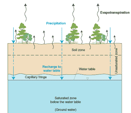
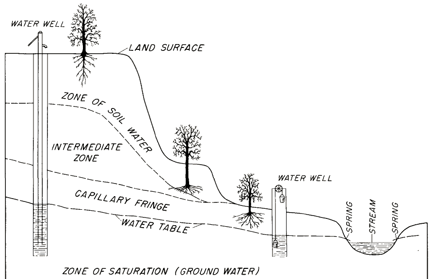
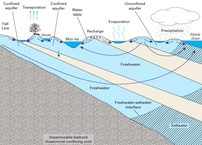
Groundwater is stratified underground in a pattern similar to a sponge that has not been used for a day. Typically, such a sponge will be dry at the top, where pores are filled with air. Further down, water molecules saturate the spaces between the pores. In soil (and in caves), the dry zone at the top is the vadose zone. The area of an aquifer where pores are filled with water is the phreatic zone. In a cave, the surface of an underground lake will show very clearly the top of the phreatic zone. In a valley, the water level in a streams also reveals the level below which the soil is saturated.
When a well is drill down into an aquifer, the underground pipe will cross from a layer of earth where pored between soil particles are filled with air ("vadose zone") to a layer with water-filled pores between soil particles. The line separating air-filled and water-filled pores is the "water table." The depth to the top of the water filling a well is the depth to the water table. Above the water table, soil is dry or moist. Below the water table, soil is saturated with water and wet.
There are water molecules trapped in the soil above the water table, and that water is essential for plant roots. Even after several days with no rainfall, there is still a capillary fringe above the water table, a soil-water zone where small pores may be wet and large pores may be dry due to the physics of surface tension and capillary action.
The number of pores with water in the vadose zone will increase after a summer rainstorm, and the water table itself will rise. During dry spells evaporation will remove that water, and lower the water table. The top of the water table can fluctuate several feet each year between summer and winter.
The lowest water table level is in the summer, when evapotranspiration of water from leaves moves groundwater from roots into the atmosphere. In the winter, rain/snow seeping into the ground will recharge the aquifer. When plants are dormant, the recharge rate is faster than the evapotranspiration rate and the top of the water table rises.
The US Geological Survey (USGS) started measuring groundwater levels in Virginia in 1928, starting with a dug well in Rosslyn where tape was used to calculate the distance between the land surface and the water level. The Federal agency recorded that the water level in a Chesterfield County well increased two feet between January-February 1943 despite precipitation being significantly below normal. There was no evapotranspiration by plants in the winter, and "what precipitation there was had the opportunity to percolate down to the zone of saturation."
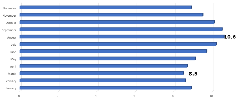
depth to the water table at a site in Prince William County is 8.5 feet in March, but drops to 10.6 in August as plants evapotranspire
Source: US Geological Survey (USGS), Groundwater Watch: Site Number: 385607077381101 - 49V 1
Shallow plant roots take advantage of the available water trapped in pores near the surface. Other roots may grow deeper, in order to tap into the water near the saturated zone below the water table.
above the water table in the vadose zone, water may fill the voids between some pores and supply water to roots of plants; below the water table in the saturated phreatic zone, water droplets occupy nearly all pores
Source: US Geological Survey (USGS), Ground Water and Surface Water: A Single Resource (Circular 1139)
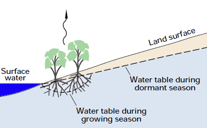
plants transpire during the growing season, sucking water from the soil and lowering the water table around the root system
Source: US Geological Survey (USGS), Ground Water and Surface Water: A Single Resource (Circular 1139)
In Virginia, a well driller might encounter the water table at 10-50 feet. Wells intended to supply single family residences are drilled much deeper than just to reach the water table. Deeper wells encounter more of the water-saturated aquifer, increasing the flow of water from the saturated zone into the well bore. Deeper wells also provide more storage, serving as a vertical (though very narrow) water tank with a well pump at the bottom.
Users in a house might pump five gallons/minute from a well to run a dishwasher, take a shower, flush toilets, etc. Irrigating a garden for an hour will drop the water level in a well closer to the water pump at the bottom. The deeper the well below the water table, the greater the amount of storage and the lesser risk of pumping a well dry. Once pumping ceases, recharge from the saturated aquifer will slowly refill the underground, vertical "tank."
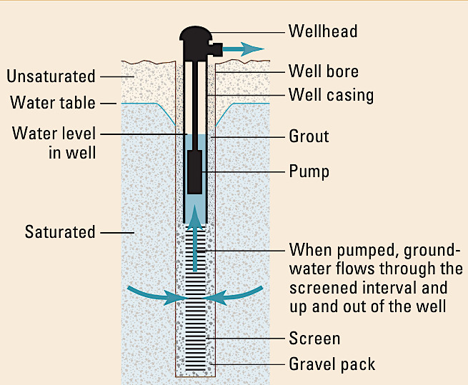
well casing and a sealant (grout) near the surface prevents potentially contaminated water from flowing into a drinking water well
Source: US Geological Survey (USGS), Water Quality in the Glacial Aquifer System, Northern United States, 1993–2009 (Circular 1352)
The drinking water well producing the greatest amount of water, 40 million gallons daily, is at Kansas City. The well is only 135 feet deep, but it has multiple lateral wells drilled horizontally at that depth to bring water from the aquifer to the well bore. 90% of that groundwater is recent recharge from the nearby Missouri River, and:5
A well that extracts water faster than it is recharged into the aquifer will dry up surrounding sediments. Normal removal will create a short-term "cone of depression," which typically will disappear overnight as water moves sideways into the drained pores near the well bore. Excessive removal can create a cone of depression that can lower the local water table beyond a well-owner's property line, affecting the groundwater supply of the neighbors.
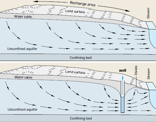
pumping groundwater from a well can create a cone of depression, lowering the water table near the well
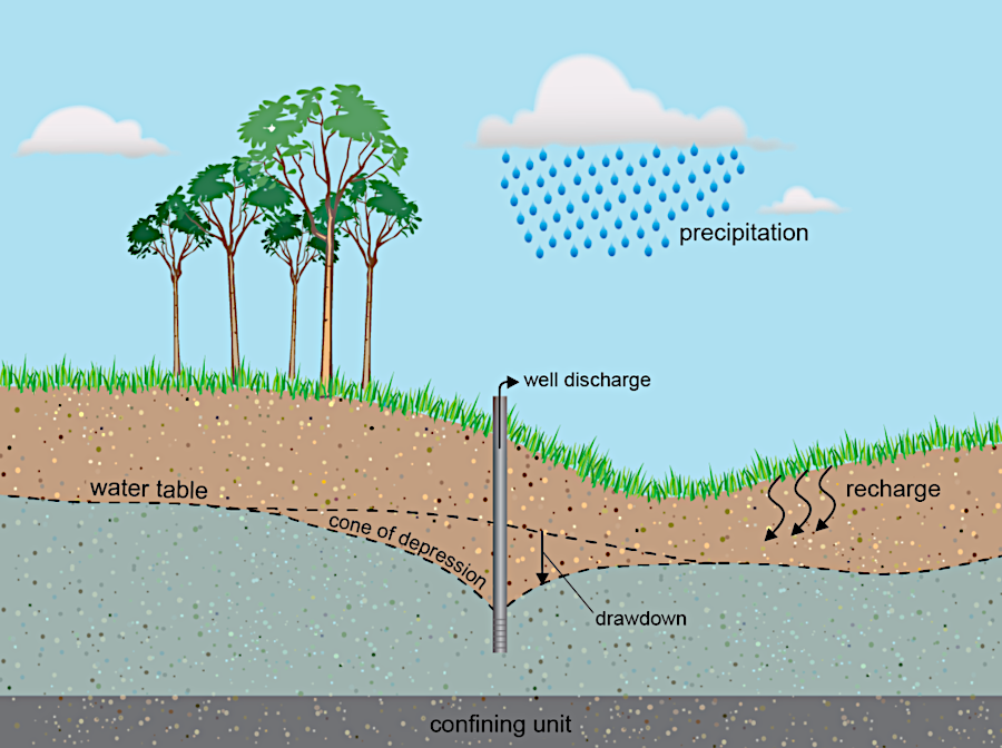
Source: US Geological Survey (USGS), Ground Water and Surface Water: A Single Resource (Circular 1139) and Cone of depression: Pumping a well can cause water level lowering
Nationwide, 40% of the population uses groundwater for drinking water. In Virginia, over one million households rely upon private wells for drinking water. Most drinking water wells for single family residences in Virginia are drilled 70-400 feet deep. For industrial or municipal supply, wells are often drilled much deeper to ensure a greater flow of water.
To supply the town (now city) of Fairfax before it implemented a water supply system based on surface water (Goose Creek and Beaverdam Creek, in Loudoun County), municipal wells were drilled from 165 to 809 feet deep and yielded 15 to 125 gallons/minute.6
wells are drilled deep enough to get below the water table
Source: US Geological Survey (USGS), Geology and Ground-Water Resources of the Fairfax Quadrangle (USGS Water-Supply Paper 1539-L)
Drilling deep allows drillers to intersect multiple layers of water-soaked rock, or to intersect enough vertical distance in one aquifer to supply the minimum required. With enough water oozing from the ground into the well through holes in the well casing, a typical well is designed to supply at least five gallons/minute - enough water for multiple showers/cooking in the morning without emptying the well completely.
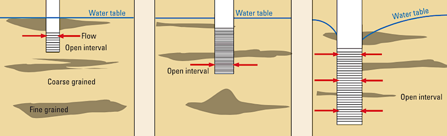
wells can be drilled deeper to intercept more aquifers, increasing flow into the drilled bore
Source: US Geological Survey (USGS), Water Quality in the Glacial Aquifer System, Northern United States, 1993–2009 (Circular 1352)
A deep well also serves as a storage tank. In the course of a day, a well should normally recharge with water from adjacent rock formations before a family comes home in the evening and pumps water from the well into the house again.
Drinking water from most wells is not chlorinated or disinfected with ultraviolet light, and well water is not fluoridated either. Well water has fewer non-natural chemicals, which is a benefit if you keep fish in an aquarium.
Well water may include excessive amounts of calcium (creating "hard water"), iron, or sulfur. Homeowners may choose to buy water conditioning systems to control odor and minimize stains on laundry, or to reduce hardness by replacing calcium with sodium. The cost of a water softening system, including one or more bags of salt each month to reduce hardness so soap will produce lather in the shower, may equal to the cost of purchasing municipal water.
Where a stream valley has eroded down to the level of the water table at the top of the aquifer, water emerges at a spring. Springs are common on valley hillsides near the bottom, but springs may also emerge within the bed of a stream. A spring may emerge with enough force to push around sand grains constantly on the stream bottom, creating a clearly-visible disturbance that may be called a "boiling spring."
groundwater can move through porous sediments and emerge as an underwater, "boiling" spring at the bottom of a stream
Source: US Geological Survey (USGS), Ground Water and Surface Water: A Single Resource (Circular 1139)
If the water table drops during the summer, when evapotranspiration increases, a spring may dry up, only to re-appear in the winter once the water table rises again. Water levels can fluctuate 15 feet annually. The prime recharge period when the water table rises is during the winter, particularly between January-April when evapotranspiration by plants is low.
Water that goes into the ground can emerge at a spring, flow to a nearby stream, or be pumped back to the surface through artificial wells drilled down into an aquifer. If the well is not deep enough, or intersects few bedrock fractures/zones of permeable bedrock below the water table, then the well may go dry in late summer:7
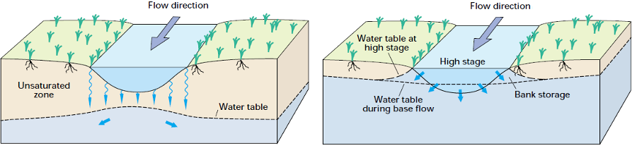
water flowing downstream may seep into nearby sediments and move down to the local water table, or may raise the height of the water table next to the streambed
Source: US Geological Survey (USGS), Ground Water and Surface Water: A Single Resource (Circular 1139)
Groundwater that emerges from springs/wells started as surface water. Whatever the raindrops absorbed in their travel through the atmosphere and into the ground will be carried underground. Some underground minerals, especially limestone, may be dissolved as water flows through bedrock. Only in a few places in Virginia are minerals in the bedrock (such as arsenic and iron) the source of contamination that reduces the potability of groundwater.
Around Saltville, water originally trapped in the underground salt deposits when the sediments were deposited plus some surface recharge comes to the surface and creates saline springs. Groundwater brings sodium to the surface in other parts of the Valley and Ridge physiographic province, creating salt licks that attract animals. The minerals in the springs created good hunting locations for Native Americans and colonial pioneers. Enough saline water emerged via natural springs at one site for it to become known as Big Lick. After the Norfolk and Western Railroad arrived, the site was renamed Roanoke.
The aquifer may be contaminated with gasoline or heavy metals from automobile brake particles on pavement, or from bacteria from animal feces - but in many cases, the soil particles will trap the contaminants.

rainfall recharges aquifers, and can carry contaminants from the atmosphere and surface to pollute groundwater
Source: US Geological Survey (USGS), Ground Water Atlas of the United States: Delaware, Maryland, New Jersey, North Carolina, Pennsylvania, Virginia, West Virginia (HA 730-L)
For organic contaminants, bacteria, ultraviolet rays, or other natural factors may decompose the molecules and clean the groundwater before it emerges at a spring/well. In limestone karst areas, however, the pores and permeability underground may be sufficient for contaminants (even items as large as corn cobs) to migrate underground. If a sinkhole is used as a garbage dump, then the waste is likely to reappear at a spring nearby.
Government agencies now encourage developers to direct runoff to seep into groundwater rather than to surface streams. The Chesapeake Bay Preservation Act regulations ("Ches Bay regs") require a 100-foot wide buffer on either side of perennial streams in most of Tidewater Virginia. Buffers of undisturbed vegetation along streams allow sediment to be trapped by grass/leaves on the ground before runoff carries the particles to the stream. Without buffers, sediment clogs streams while also carrying excessive amounts if nutrients (nitrogen and phosphorous) into waterways.
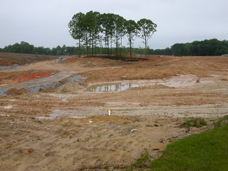
stripping vegetation from soil surface while developing land opposite McCoart Administrative Center (Prince William County)
Low Impact Development (LID) projects are now designed to minimize surface runoff, by diverting and retaining rainfall so it soaks into the ground. Depressions filled with permeable soil or even rock (French drains) trap runoff from roofs and parking lots. If LID projects are designed correctly and maintained, the runoff soaks into the ground slowly rather than flows to a nearby stream. LID projects can fail where there is too much clay in the soil, or silt/debris accumulating in a depression blocks rainwater from seeping into the ground.
One potential long-term impact of diverting surface water underground: modern pollution may be pushed into the groundwater, polluting underground aquifers. Plumes of polluted groundwater from leaking underground storage tanks at gas stations, or from improper disposal of hazardous waste in deep wells, can create serious environmental impacts for many, many years.
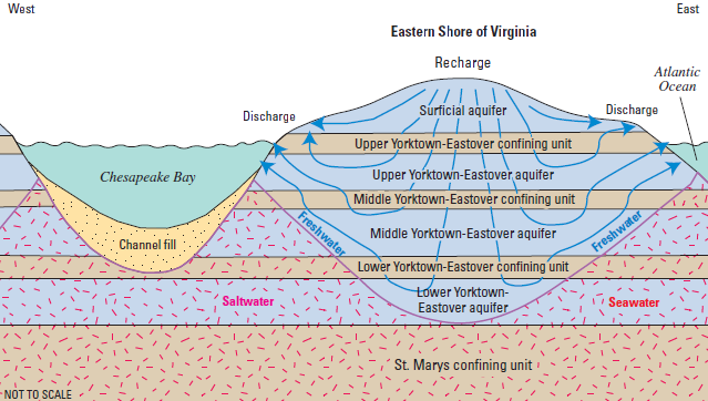
on the Eastern Shore, groundwater flows east to the Atlantic Ocean and west to the Chesapeake Bay
Source: US Geological Survey, Simulation of Groundwater-Level and Salinity Changes
in the Eastern Shore, Virginia (Figure 14)
On the Eastern Shore, nitrogen and phosphorus have been applied at high rates to the soil for farming and for disposal of wastes from chicken-raising operations. Crops have not used all the nutrients; agricultural operations have overloaded the sandy soils. The excess nitrogen has been transported downstream through groundwater as nitrate "at concentrations that are well above natural levels, and are among the highest in the Nation" (according to the US Geological Survey). The insoluble phosphorus, another major pollutant damaging the Chesapeake Bay, ends up attached to particles of sediment and transported to local streams through overland erosion.8
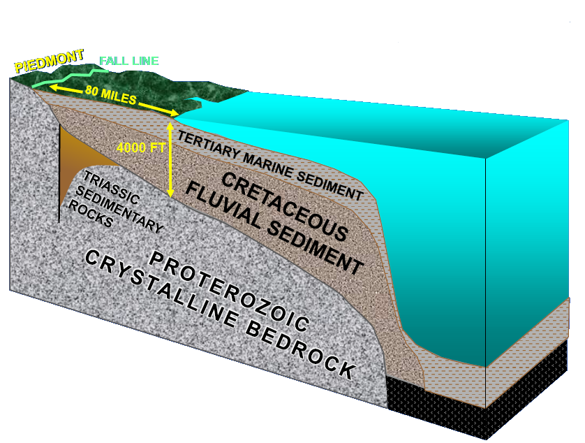
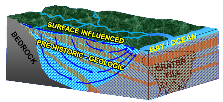
Bedrock is exposed in the Blue Ridge and to the east in the Piedmont. During the Cretaceous Period, freshwater rivers flowed on top of the exposed crystalline bedrock of various "terranes," the chunks of igneous/metamorphic crust that had been added to the North American continent as the Iapetus Ocean closed. Dinosaurs were wandering through the basins that had first formed in the Triassic Period, and their heavy feet crushed some of the early flowering plants evolving on the Cretaceous soils and contributed ever so slightly to erosion of surface soils.
The rivers carried eroded sediments down from the west. They formed deltas and sandbars that extended the coastline further east, comparable to the way the Mississippi River has deposited sediments along the Gulf Coast. The sediments deposited over the last 200 million years created the Coastal Plain. Groundwater flows far easier through the fragmented particles in those sediments than through the fractures in the bedrock west of modern I-95.
idealized flow of rainwater across surface and underground in Coastal Plain physiographic province
Source: US Geological Survey, Ground Water in Freshwater-Saltwater Environments of the Atlantic Coast (Figure 3)
The largest grains of sand stayed where the crust was warped upward at the Norfolk Arch along today's Peninsula, while smaller clay particles moved to the lower-energy waters in depressed embayments to the north (Salisbury Embayment in Maryland) and south (Albemarle Embayment in North Carolina).
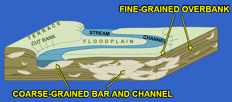
coarse-grained sand deposited in river channels during the Cretaceous Period created porous sediments that transmit water, while fine-grained clay particles that settled out in floodplains and slow-moving environments now block water flow in underground aquifers
Source: Randy McBride, US Geological Survey, The Potomac Aquifer of the Virginia Coastal Plain
Today, the Cretaceous sediments above the Norfolk Arch form an unconsolidated aquifer with patches of impervious clay. The Cretaceous Period deposits underneath the Potomac River and Chowan River include broader layers of clay, creating confining units that separate aquifers.
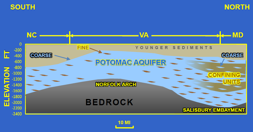
above the Norfolk Arch, coarse-grained sediments now form a continuous aquifer without confining units that form separate aquifers
Source: Randy McBride, US Geological Survey, The Potomac Aquifer of the Virginia Coastal Plain
During the Paleocene, Eocene, Oligocene, Miocene and the Pliocene epochs (formerly called the Tertiary Period), sea levels rose and fell, alternately drowning and exposing the eastern part of Virginia. Marine sediments covered the freshwater sediments of the Cretaceous Period until the Pliocene Period, 3 million years ago. Sedimentary deposits were fragmented during both freshwater and marine deposition; there are no hydrogeologic units today that stretch across the entire Coastal Plain.9
the aquifers on the Coastal Plain are in sediments deposited in the last 145 million years
Source: Randy McBride, US Geological Survey, The Potomac Aquifer of the Virginia Coastal Plain
The geologic formations deposited since the Cretaceous vary in their capacity to store water and serve as aquifers for human use:10
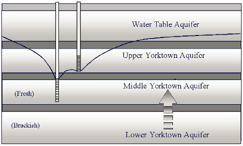
aquifers can be separated by "confining units" of less-permeable clay, and can have water of different quality (especially salinity, if near the Chesapeake Bay/Atlantic Ocean)
Source: Technical Analysis and Justification for Ground Water Ordinances on the Eastern Shore of Virginia (Figure 1-1)
One description of the Mid-Atlantic Coastal Plain noted:11
typically, groundwater in deep aquifers is older than groundwater in shallow aquifers
Source: US Geological Survey (USGS), Water Supply Paper 2220, Basic ground-water hydrology
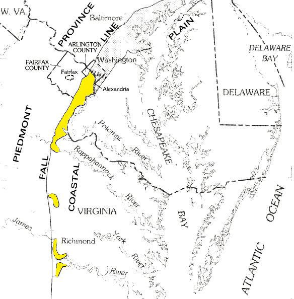
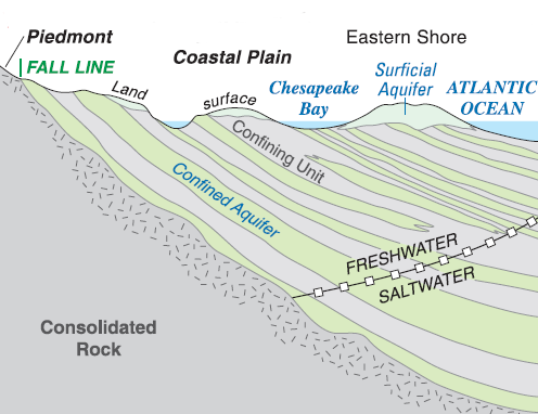
West of the Fall Line, the recharge area (the source of the groundwater, where raindrops seeped below the surface) will be located close to a natural spring or human-drilled well. In the Piedmont's decomposed soil/bedrock near the surface known as "saprolite," groundwater moves as it does in the Coastal Plan between the pores of the sediment grains. In the crystalline bedrock of the Piedmont, however, groundwater is found in the fractures and is not evenly distributed.
Even in the Blue Ridge, igneous rocks are sufficiently fractured to allow surface waters to seep into the ground, and be pumped back to the surface wherever a well intercepts a fracture. If the elevation of the recharge area is higher than the elevation of a well, the "piezometric level" (where pore water pressure equals atmospheric pressure) can be higher than the elevation of the well bore.
Under such conditions, water can flow under pressure out of an artesian well without requiring any pumping. Until development after World War II drained water from the Potomac Formation underneath the Coastal Plain, the aquifer was under such pressure that water would rise seven feet above the surface when a driller penetrated the sediments for a deep well.
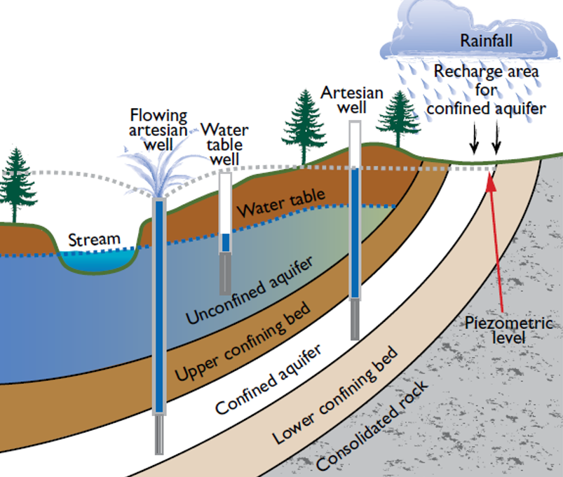
water can flow naturally out of artesian wells if the well opening is below the piezometric level (where pore water pressure equals atmospheric pressure)
Source: US Geological Survey (USGS), Artesian wells can bring water to the land surface naturally
in artesian wells which penetrate confining aquifers, water under pressure will rise higher than the water table
Source: US Geological Survey (USGS), Basic Ground-Water Hydrology (Water Supply Paper 2220)
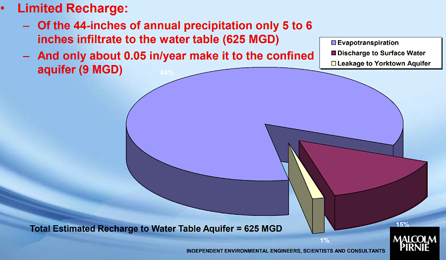
Of the 43" of rain that falls annually on Virginia's Coastal Plain, 10" infiltrates underground but only 1" reaches the deep layers of the aquifer. Most groundwater flows to nearby streams, or is captured by plant roots and recycled to the atmosphere by evapotranspiration.
The time required for a raindrop that soaked into the ground to re-emerge varies. In the growing season, a root may recycle water with just a few days. If the rainfall seeps into sediments near the surface, or into cracks in igneous/metamorphic formations, it may spend years or decades slowing migrating to the edge of a stream channel before emerging in a spring. Groundwater extracted at Indian Head, Maryland (across the Potomac River from Quantico Marine Corps Base in Prince William County) has been underground about 35 years.
Due to the slow flow of groundwater through most porous and permeable rock formations (10' per year above the Norfolk Arch, but as slow as 0.1' per year through the clay-rich sediments above the Salisbury Embayment), a raindrop may spend centuries or even thousands of years underground before re-emerging at the surface.12
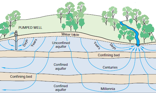
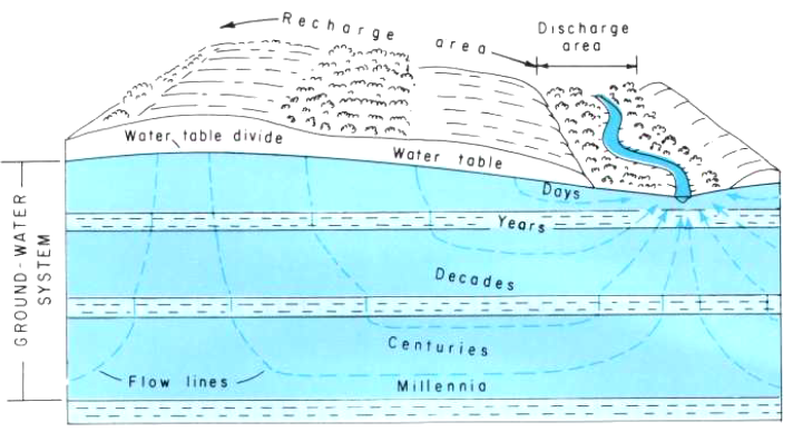
rainwater that soaks into the ground may spend only days underground before seeping into a stream (or being extracted through a well), but a small percentage of raindrops will spend 100's to 1,000's of years underground before returning to the surface
Source: US Geological Survey (USGS), Ground Water and Surface Water: A Single Resource (Circular 1139); Britt McMillan, Malcolm Pirnie, Inc., Our Eastern Shore Groundwater Part I: Where is the groundwater and how much is there?
Suspended materials will settle out of groundwater as it moves slowly. Bacteria and some dissolved elements such as phosphorus will be trapped on the edge of soil molecules. Other elements such as nitrogen will stay dissolved in the groundwater, but be removed when intercepted by plant roots.
However, the length of time spent traveling underground does not guarantee high water quality. Polychlorinated biphenyls (PCB's) and radionuclides may contaminate the groundwater for centuries before it returns to the surface. Per- and polyfluoroalkyl substances (PFAS) are known as "forever chemicals" because they degrade so slowly. Groundwater appears clear because suspended particles have settled out, but dissolved contaminants may still be present.
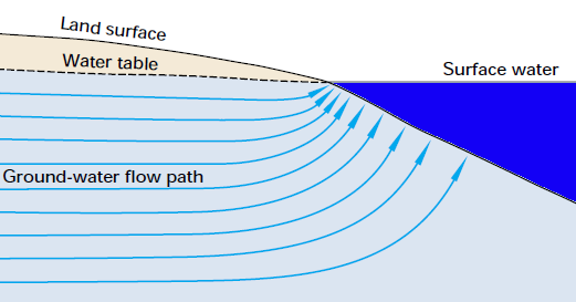
groundwater emerges at the surface where streams and lakes intersect the water table
Source: US Geological Survey (USGS), Ground Water and Surface Water: A Single Resource (Circular 1139)
water entering the Potomac Aquifer at the Fall Line, in the recharge zone of Cretaceous Period freshwater sediments, can spend a million years underground as it moves eastward - while infiltration from the surface into the younger marine sediments may emerge in less than 100 years
Source: Randy McBride, US Geological Survey, The Potomac Aquifer of the Virginia Coastal Plain
groundwater that seeps into the deep sediments takes longer to re-emerge at the surface
Source: Randy McBride, US Geological Survey, The Potomac Aquifer of the Virginia Coastal Plain
Folk tales of long-distance underground transport are overstated:13
The Northern Neck Bottling Company, located in Montross in Westmoreland County, bottled Carver's Original Ginger Ale starting in 1926. Northern Neck Bottling Company expanded to produce Northern Neck Ginger Ale as well. Both had a distinctive "bite" of ginger.
The Coca-Cola company purchased the bottler in 2001 and moved operations from Montross to Sandston, east of Richmond. Nonetheless, a delegate in the General Assembly representing Montross proposed in 2019 to designate Northern Neck Ginger Ale as Virginia's "official soft drink." In 2020, the Atlanta-based corporation decided to "retire" the ginger ale brands along with other underperforming products. During the COVID-19 pandemic, there was a shortage of aluminum cans which constrained production of products with just a niche market.
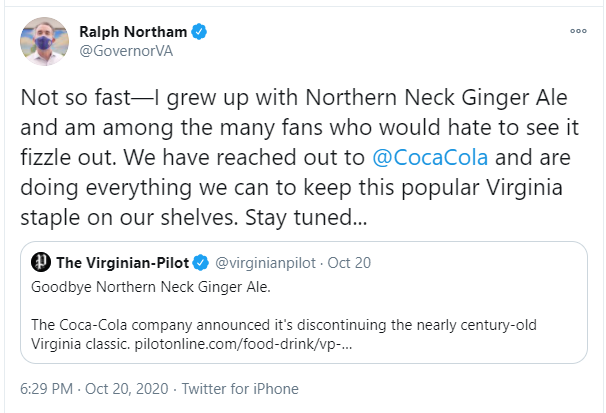
even the governor of Virginia sought to keep Northern Neck Ginger Ale in production
Source: Twitter, Gov. Ralph Northam (October 20, 2020)
The Northern Neck Bottling Company had claimed its ginger ale was special in part because the main ingredient came from a 650-foot deep artesian well, and:14
Underground flow directly from the Blue Ridge to the Coastal Plain is not likely. Water that seeps into the fractures of the igneous bedrock of the Blue Ridge would emerge at springs once encountering low elevations nearby.
Though there are Triassic basins east of the Blue Ridge, there are no sedimentary formations facilitating groundwater migration all the way to the Fall Line. Instead, groundwater would need to find linked fissures and fractures that extended over 40 miles within the metamorphic Piedmont formations - and not seep out to the surface at springs or within stream channels.
For mountain raindrops to get 650 feet under the Northern Neck, raindrops falling on the Blue Ridge would flow down the Potomac/Rappahannock rivers, then seep underground near the Fall Line where the the Potomac Formation was exposed at a recharge zone of the aquifer. The "Blue Ridge water" entering the recharge zone of the Potomac Formation near the Fall Line is mized with rain that fell on the Piedmont.
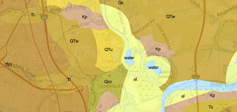
outcrops of Potomac Formation (Kp) near Fall Line
Source: US Geological Survey (USGS, Bulletin 1556, Engineering Geology and Design of Slopes for Cretaceous Potomac Deposits in Fairfax County, Virginia, and Vicinity (Figure 1); Virginia Energy, Geology and Mineral Resources
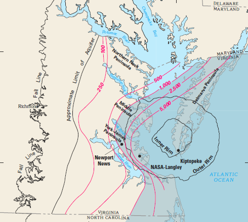
Northern Neck wells draw from sources far away, but just not much from as far as the Blue Ridge. Aquifers in the Coastal Plain may be recharged from as much as 20-50 miles away, where sedimentary formations are exposed at the Fall Line. Nationwide, 90% of watersheds defined by surface topography have groundwater beneath them that flowed through underground channels, cracks and pores from an adjacent watershed.
For millions of years, rainfall has seeped into the Potomac Formation and other geologic units where they have been exposed to the surface. Rain that falls today just west of Fredericksburg and Richmond can flow eastward, downward - and slowly - to end up in an aquifer hundreds of feet beneath the surface at Hampton Roads. That journey may require thousands of years.
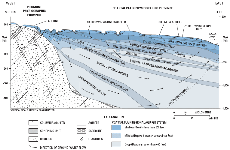
Coastal Plain aquifers in Virginia
Source: US Geological Survey (USGS), Aquifer Susceptibility in Virginia, 1998-2000 (Water-Resources Investigations Report 03-4278)
Water in the Lower Potomac Aquifer was trapped when the sediments were first deposited in the Cretaceous Period. Over time, the original groundwaer has leaked into the Atlantic Ocean and been replaced slowly with water from recharge areas still exposed at the surface.
On the eastern side of the Coastal Plain where sediments are as much as 6,000 feet deep, the Upper/Middle/Lower Potomac aquifers are largely isolated from the surface. A raindrop falling today on places such as Suffolk and Newport News has a difficult time seeping through vertical cracks in confining aquifers all the way to the basement. The Potomac Formation is exposed at the surface near the Fall Line, so recharging raindrops migrating eastward to the sediments deep under Virginia Beach have a long way to travel.
Recharge rate is a significant policy issue. If deep aquifer isolation is complete, then groundwater pumped to the surface from such sources will not be replenished. If groundwater is not renewable, then pumping from deep aquifers should be managed as a one-time mining process, comparable to extraction of coal or quarrying/crushing basalt for construction projects.
Southeastern Virginia Aquifer System
Source: City of Franklin Comprehensive Plan, Franklin 2010 (Figure 4-3)
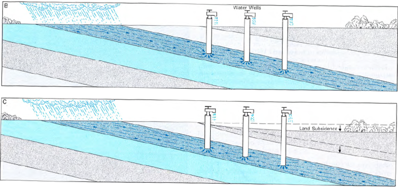
The municipal and industrial wells in Hampton Roads, the Peninsula, the Middle Peninsula, the Northern Neck, and the Eastern Shore do not dry up immediately once pumping starts. Droplets of water trapped in the pores between sediment particles move as underground pressures change during pumping. Groundwater flows just like surface water, especially in aquifers that are highly permeable, but the flow rate is slower. In aquifers near the surface, raindrops seep into the ground. They replace the water droplets that escape to the surface at springs, or are pumped out of the ground via drinking water and industrial wells. In deeper aquifers, horizontal recharge occurs as water droplets move from a nearby pore space and fill a gap when a droplet reaches the surface.
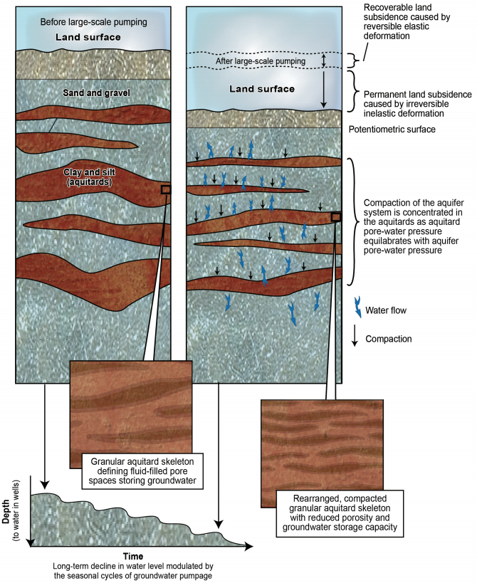
Over centuries and millennia, groundwater recharge in deep aquifers can occur via transport from Fall Line exposures of a sedimentary layer or directly from the surface. However, the gap once filled by a droplet could remain and be filled with air, or the pore could disappear as adjacent sedimentary particles realign and slide into the space. If enough particles move and compact the former spaces, the ground level at the surface may subside.
when groundwater is withdrawn, gaps between soil particles compress and the land surface can subside
Source: US Geological Survey (USGS), Land Motion and Subsidence on the Virginia Coastal Plain
Clay sediments compact when the water is withdrawn, creating land subsidence. Sand grains may not compress nearly as much. If water is injected back into an aquifer, water can fill the pores again between the sand grains. If the sand grains compacted when water was removed, injected water will fill the smaller pore space that remains. However, the increased water pressure created by injection will not be sufficient to push sand grains apart and uplift the surface.
The pores that once existed between mud particles disappear when the water is removed. Injection of water into mud zones deep underground is less likely to repressurize an aquifer. Clay-rich zones create confining units that separate aquifers.
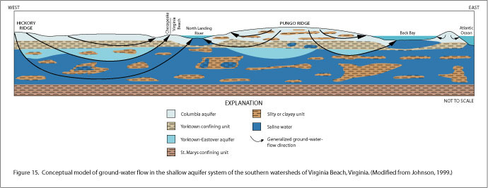
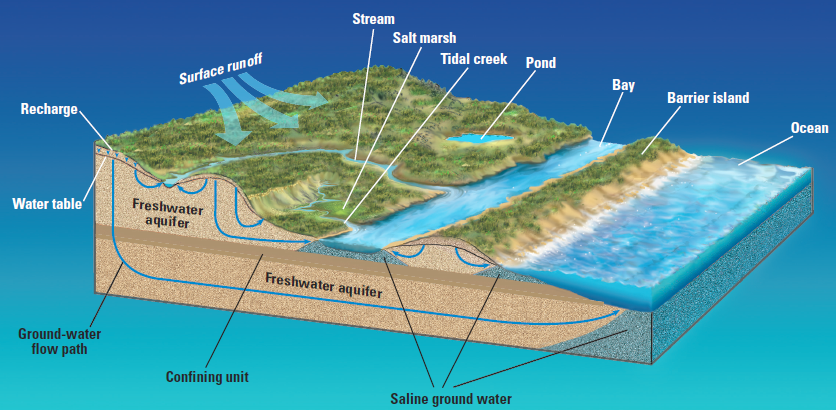
conceptual model of shallow aquifer recharge and underground flow in southern part of Virginia Beach showing how "confining units" can be fragmented and allow rainwater to soak underground through Columbia aquifer into Yorktown-Eastover aquifer... and how saltwater can intrude and affect shallow wells
Source: US Geological Survey (USGS), Conceptual Hydrogeologic Framework of the Shallow Aquifer System at Virginia Beach, Virginia, Water-Resources Investigations Report 01-4262 (Figure 13)
Confining units in the Coastal Plain are not 100% impervious; fluids do migrate vertically between sub-surface layers of sediments. Some rain that falls on the Coastal Plain could end up in the aquifers under the surface, soaking as deep as the Potomac Aquifer.
Confining units do limit the speed and volume of "leakage" between different aquifers. So long as rainfall exceeds withdrawal, and the ground surface remains pervious, then freshwater will move underground due to gravity. The freshwater is lighter than saltwater, so freshwater will "float" on top of saltwater underground.
sediments form aquifers and confining layers, typically with heavier saltwater underneath freshwater
Source: US Geological Survey (USGS), Effects of Withdrawals on Ground-Water Levels in Southern Maryland and the Adjacent Eastern Shore, 1980-2005 (Scientific Investigations Report 2007-5249, Figure 3)
However, if wells pump freshwater out of an aquifer faster than that aquifer is recharged from the surface or adjacent freshwater zones, then saltwater or brackish water in the Chesapeake Bay estuaries may intrude further into aquifers underneath the Coastal Plain.
saltwater could intrude the aquifers on the Coastal Plain as freshwater is pumped out for human use
Source: Randy McBride, US Geological Survey, The Potomac Aquifer of the Virginia Coastal Plain
Drinking water/industrial wells also can be affected if freshwater recharge is altered by stormwater systems that carry rain quickly to streams, rather than allow the rainwater to soak into the ground:15
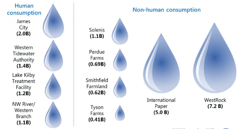
14 permittees are responsible for the vast majority of groundwater withdrawals from the Potomac Aquifer
Source: Hampton Roads Planning District Commission, Groundwater Withdrawal Permits (October 16, 2014)
Groundwater may be a renewable resource, but an aquifer can be drained faster than it recharges naturally. Based on legislation passed by the General Assembly in 1992, the Virginia Department of Environmental Quality (DEQ) designated two Ground Water Management Areas, one on the Eastern Shore and one west of the Chesapeake Bay, to prevent excessive use of the limited natural resource.
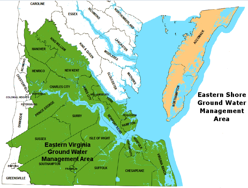
prior to 2014, the Eastern Virginia Ground Water Management Area was limited to the southern portion of the Coastal Plain
Source: Virginia Department of Environmental Quality, Ground Water Withdrawal Permitting Program
Within the boundaries of the two Ground Water Management Areas, state permits are required to withdraw more than 300,000 gallons/month, and permits must be renewed every 10 years. That threshold excludes all but the largest industrial and municipal users withdrawing groundwater via wells.
From an irrigation perspective, 300,000 gallons/month is about one acre foot. Farmers irrigating 11 or more acres with one inch of water, once a month during the summer, will reach the threshold and need to get a permit.16
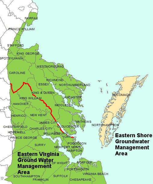
the Eastern Virginia Ground Water Management Area was expanded after 2014 to include the northern portion of the Coastal Plain (north of red line)
Source: Virginia Department of Environmental Quality (DEQ), Ground Water Withdrawal Permitting Program
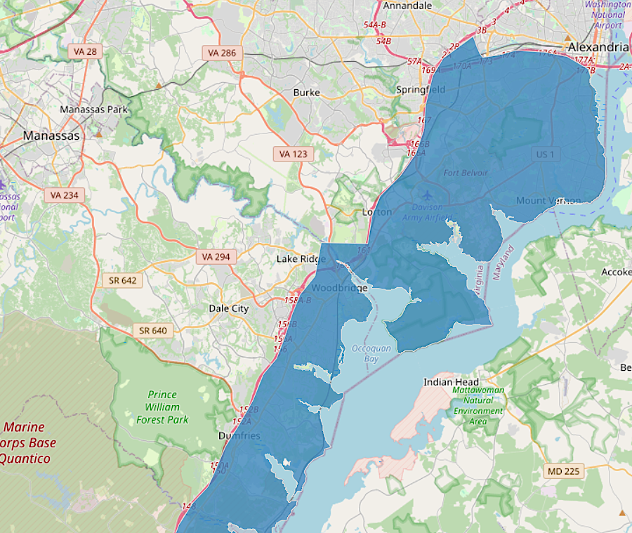
the Eastern Virginia Ground Water Management Area now extends to Alexandria
Source: Hampton Roads Planning District Commission, Eastern Virginia Groundwater Management Area
The intent of the permitting program was to prevent conflicts between existing and new users. Limiting new withdrawals protected the ability of the two paper mills at West Point and Franklin to continue to withdraw millions of gallons of groundwater for industrial use, but also protected existing public water supplies that relied upon wells drilled on the Coastal Plain. New permittees had to mitigate impacts on existing well owners affected by new withdrawals.
the WestRock paper mill in West Point and the International Paper mill in Franklin are the largest users of groundwater in Virginia
Source: Joint Legislative Audit and Review Commission, Effectiveness of Virginia's Water Resource Planning and Management
lowered groundwater levels, resulting from industrial use by paper mills at Franklin and West Point
Source: US Geological Survey, Simulation of Groundwater Flow in the Coastal Plain Aquifer System of Virginia, Scientific Investigations Report 2009-5039 (Figure 32b)
Groundwater provides nearly all the public and private drinking water in the Coastal Plain north of the York River. There are no surface water reservoirs on the Northern Neck supplying public utilities. There is just one reservoir on the Coastal Plain of the Middle Peninsula used for drinking water, Beaverdam Lake in Gloucester County.
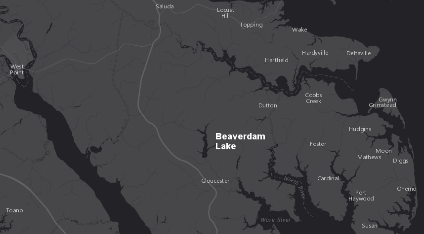
within the Coastal Plain north of the York River, groundwater supplies drinking water for all public systems - with the exception of Beaverdam Lake in Gloucester County
Source: ESRI, ArcGIS Online
South of the York River on the Peninsula, dams rather than wells have been used to create drinking water reservoirs. Newport News dammed Skiffes Creek in 1918 to provide drinking water. The cost to upgrade the dam to meet safety standards was $14-20 million and the Skiffes Creek reservoir provided just 5% of the water supply, so the city decided to remove the dam instead.
Diascund Creek was dammed in 1963 and Little Creek in 1981 to provide drinking water, along with water pumped from the Chickahominy River above Waler's Dam. The city's proposal to build a dam across Ware Creek to create the King William Reservoir was blocked by the US Army Corps of Engineers. The project would have impacted wetlands, and the Federal agency did not accept the city's projections for future demand for drinking water.
Much of the drinking water in the southern half of Hampton Roads comes from groundwater, except for water imported by Virginia Beach visa a pipeline stretching from the Roanoke River.
All of the drinking water on Virginia's Eastern Shore comes from groundwater. Shallow wells draw from the Columbia aquifer; deeper wells from the Yorktown-Eastover aquifer. Because there is no realistic option of using surface water for municipal and industrial use, in 1997 the Environmental Protection Agency (EPA) designated the Columbia and Yorktown-Eastover Multiaquifer System as a "sole source aquifer."
No other aquifers in Virginia have received that designation. It requires the Environmental Protection Agency to review all projects receiving Federal financial assistance, to ensure the water source will remain protected for drinking water use.
the only designated sole source aquifer in Virginia is the Columbia and Yorktown-Eastover Multiaquifer System on the Eastern Shore
Source: Environmental Protection Agency (EPA), Sole Source Aquifers
Department of Environmental Quality permits do not conserve all the groundwater, or even ensure a sustainable level of use. The permits authorize permanent reduction of the groundwater resource (i.e., mining it like gold or coal), but limit withdrawals so they avoid dewatering below the "vadose zone" at the top of the aquifer. Draining the aquifer below the top of the saturated zone could result in permanent compaction of the silt particles, preventing future recharge and potentially causing ground subsidence at the surface.
On Virginia's Coastal Plain, land is subsiding at 6 millimeters/year. That is almost twice the 3.3 millimeters/year rate at which sea levels are rising globally. To measure subsidence more accurately, the US Geological Survey installed a new extensometer in 2024 in the town of West Point. That steel rod stretches from the land surface to the base of the Potomac Aquifer, which at West Point is 1,400 feet underground. Three other US Geological Survey extensometers are in operation on the East Coast. All are in Virginia's Hampton Roads region, with one at Franklin and two in Suffolk.
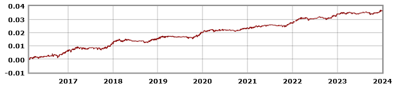
an extensometer in the City of Suffolk has measured subsidence since 2016
Source: National Water Information System, US Geological Survey (USGS), USGS 364512076343701 58C 52, [Cumulative since 2/19/2016]
Some subsidence is due to the slow isostatic rebound of the land after melting of the Wisconsin ice sheet. The weight of the ice had bent down the land in Pennsylvania and New York, and that weight caused the Coastal Plain of Virginia further south to curl upward.
Some of the land subsidence in the Hampton Roads area has been caused by groundwater removal for municipal and irrigation use, and for paper plants in Franklin and West Point. The water and waste utility for Hampton Roads, HSRD, has launched the Sustainable Water Initiative for Tomorrow (SWIFT) project to injected treated wastewater into the Potomac Aquifer. That is designed to repressurize the aquifer, compensating for groundwater removal and reducing compaction.
In one of the more dramatic examples of groundwater withdrawal leading to land subsidence, excessive pumping from groundwater aquifers caused the town of Corcoran, California to drop nearly 12 feet in just one decade. That "poster child" for groundwater management led the state's legislature to pass the Sustainable Groundwater Management Act. It required that groundwater extraction could not exceed recharge, but set the deadline at 2040. Corcoran was predicted to drop in elevation up to 11 more feet before then.17
industries and municipalities have already withdrawn an excessive amount of groundwater in Eastern Virginia, lowering the water level below the top of the aquifer
Source: Utah Geological Survey, Subsidence In Sedimentary Basins Due To Groundwater Withdrawal For Geothermal Energy Development (Open File Report 601, Figure 1)
When reviewing applications for groundwater withdrawal permits in Virginia, the initial concern was the 80% drawdown criterion. The state agency wanted to prevent water levels in any confined aquifer from dropping "below a point that represents 80% of the distance between the historical prepumping water levels in the aquifer and the top of the aquifer."18
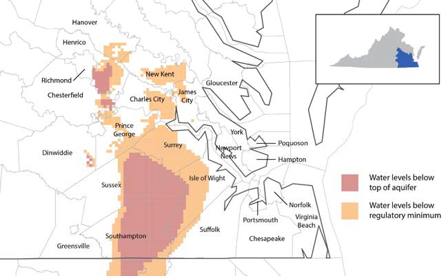
industries and municipalities have already withdrawn an excessive amount of groundwater in Eastern Virginia, lowering the water level below the top of the aquifer
Source: Joint Legislative Audit and Review Commission, Effectiveness of Virginia's Water
Resource Planning and Management
After the 2002 drought, the General Assembly required localities to develop water supply plans to ensure adequate drinking water for the next 40 years. The Department of Environmental Quality (DEQ) calculated that 123 million gallons per day were being pumped from beneath the Coastal Plain. That withdrawal rate could be maintained only for another 30-50 years before groundwater levels dropped too low to meet demand.
A 2006 assessment of the hydrogeologic framework on the Coastal Plain reported:19
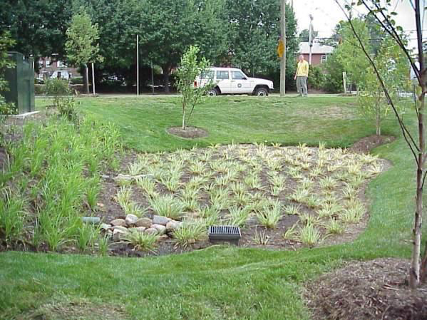
bioretention filters (rain gardens) allow stormwater to replenish groundwater aquifers near the surface
Source: Virginia Department of Recreation and Conservation, Stormwater Design Specification No. 9 - Bioretention (p.4)
State and local agencies also recognized that groundwater should be managed more comprehensively. Instead of focusing just on minimizing conflicts between permittees, the state should also limit pollution and ensure withdrawal of fresh water does not result in salt water intruding from the Chesapeake Bay into the bottom of the Potomac Aquifer.
In 2014, the state expanded the boundaries of the Eastern Virginia Ground Water Management Area to include all of the Coastal Plain north of King William County through Fairfax County, up to the boundary of the City of Alexandria. In Spotsylvania, Stafford, Prince William, and Fairfax counties, only the area east of I-95 was included.
By 2014, the Department of Environmental Quality had issued 177 groundwater withdrawal permits for the previous Eastern Virginia Groundwater Management Area, in the area designated prior to expansion. The agency calculated that the northern expansion of the Eastern Virginia Groundwater Management Area boundaries would require an additional 328 public water supply systems and 9 agricultural irrigators to obtain groundwater withdrawal permits for the first time, indicating that the expansion would protect primarily public water supply systems.20
in 2014, the state had issued permits to withdraw 147 million gallons per day within the old boundaries of the Eastern Virginia Groundwater Management Area
Source: Hampton Roads Planning District Commission, HRPDC Releases 2014 Summary of Permitted Groundwater Withdrawals in the Eastern Virginia Groundwater Management Area
The state agency also proposed that new permits issued to the top 14 users in the Eastern Virginia Groundwater Management Area would reduce the authorized level of groundwater withdrawal by 50% to approximately the current levels of use. The Department of Environmental Quality has issued permits for those heavy users that were in place in 2014, authorizing withdrawing up to 112 million gallons/day. The agency proposed cutting levels to 54 million gallons/day (current use), or even below that level to 48 million gallons/day.21
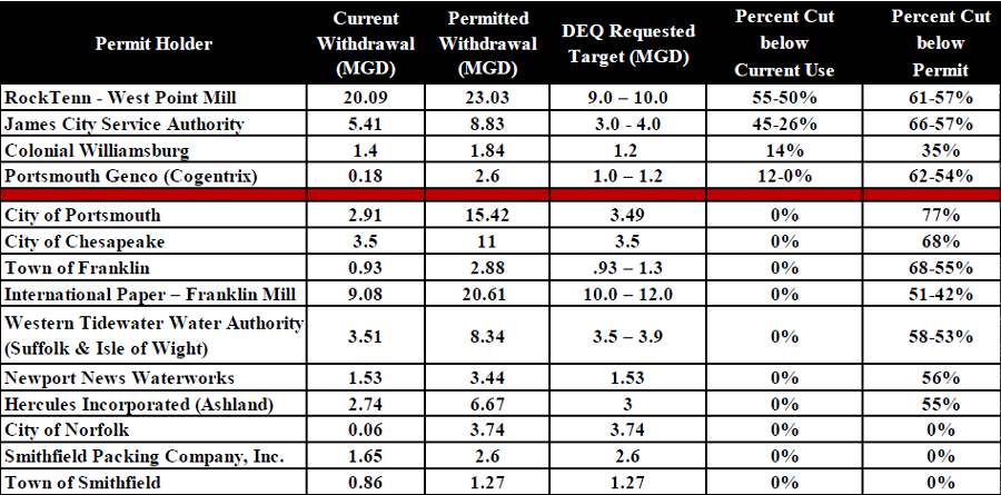
DEQ proposed in 2014 to modify permits in the Eastern Virginia Groundwater Management Area to reduce authorized use by 50%, with the largest total reduction in authorized use by the paper mills at West Point and Franklin
Source: Hampton Roads Planning District Commission, Groundwater Withdrawal Permits (October 16, 2014)
To quantify water use, the Virginia Department of Environmental Quality now requires reports of major water withdrawals from surface, plus groundwater sources within the designated Groundwater Management Areas. The water withdrawal reporting requirements are separate from the groundwater permitting thresholds:22
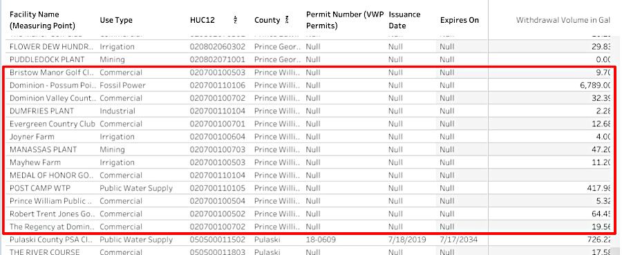
in 2023, the natural gas-fired power plant at Possum Point withdrew the most water (surface water) in Prince William County; golf courses withdrew the most groundwater
Source: Virginia Department of Environmental Quality (DEQ), myDEQ
In 2026, the Virginia Department of Environmental Quality (DEQ) reported that in the Eastern Virginia Groundwater Management Area:23
The state agency has determined that there is limited potential for permitting any additional large groundwater withdrawals from the Eastern Virginia Groundwater Management Area without crossing the critical surface threshold. The critical surface is 80% of the distance from the land surface to the top of the aquifer. In groundwater models, critical "cells" are identified when the water level drops below the surface of the aquifer.
An analysis of seven groundwater regions identified that in the western part of the Coastal Plain, industrial or commercial users should be limited to no more than 30,000 gallons per day. In Morthumberland County, the maximum would be 360,000 gallons per day.
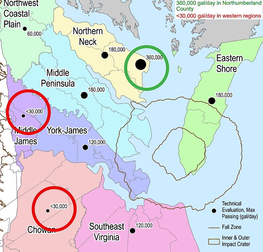
any new major withdrawals from the Eastern Virginia Groundwater Management Area risk reducing pressure below the critical threshold
Source: Virginia Department of Environmental Quality (DEQ), Limited Capacity for New GW Withdrawals
The threat of excessive groundwater withdrawal has been recognized for a long time, though government regulation to address it did not occur for decades. When Camp Peary was built during World War II, it initially relied upon 12 groundwater wells that pumped as much as 4,000,000 gallons per day before switching to a surface water supply (Waller Pond) after eight months.
Before the wells started pumping, the water level was 7-8 feet above sea level. By the time the surface water system was put into place in 1942, water levels had dropped to 15-23 feet below sea level. Pumping stopped before chloride levels increased, which would have indicated seawater was intruding into the aquifer. Salt spray from the brackish Chesapeake Bay, blown onto the land and then seeping into the ground, can also be a source of chloride in wells.
when wells remove freshwater near the Chesapeake Bay, undrinkable saltwater can intrude further into the aquifer)
Source: US Geological Survey, Chloride in Groundwater in the Coastal Plain of Virginia (p.20)
In 1945, the US Geological Survey identified industrial pumping by what was then the Chesapeake - Camp Corporation pulp mill at Franklin as the cause for a steady drop in the water level. The future impacts of that pumping were also identified:24
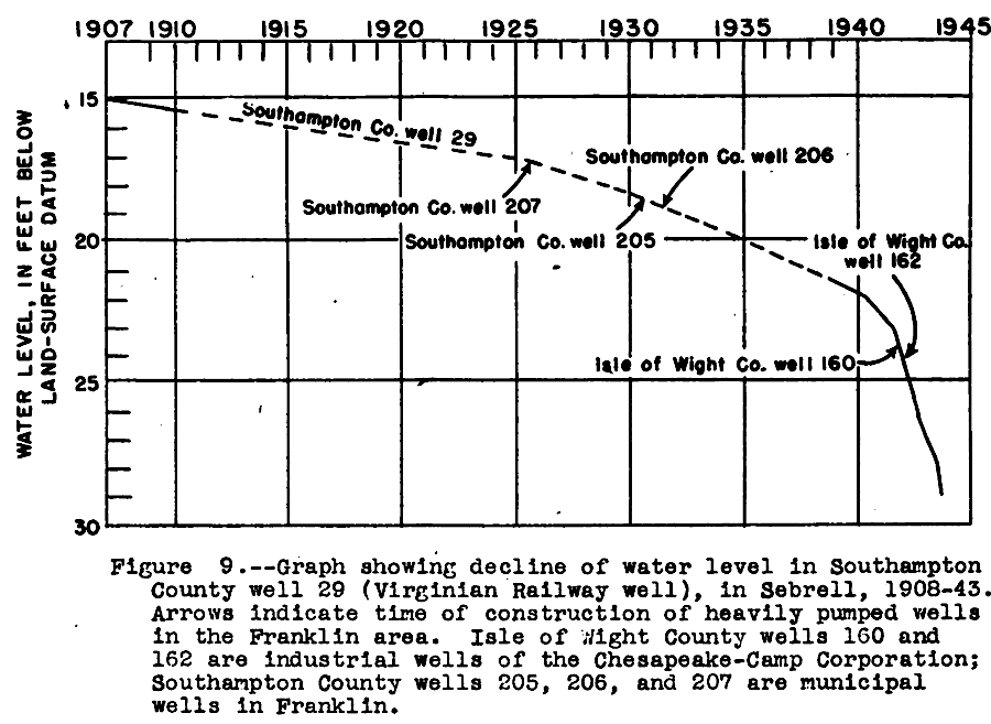
the decline in the groundwater level near Franklin was documented soon after the opening of the pulp mill there
Source: US Geological Survey, Water Levels and Artesian Pressure in Observation Wells in the United States (p.160)
impact of groundwater withdrawals for International Paper mill in Franklin, Virginia before 2009 shutdown (reductions from projected "normal" level, measured in feet)
Source: Hampton Roads Planning District Commission, International Paper Closure: Impact on Groundwater Resources
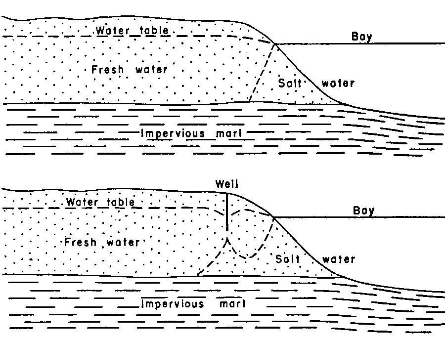
Virginia's two Ground Water Management Areas now cover 100% of the area at risk of salt water from the Chesapeake Bay/Atlantic Ocean intruding into an aquifer. There is plenty of water in the Atlantic Ocean and Chesapeake Bay to recharge aquifers in the area, but that bay/ocean water is salt water. The Atlantic Ocean salt level is 35 parts/thousand. On the Eastern Shore, rain creates a lens of fresh water that extends 300 feet deep. The fresh water floats on top of heavier salt water; wells drilled more than 300 feet deep produce water not suitable for human use.25
Water with salt levels greater than 0.5 parts/thousand is "brackish." It is less desirable for drinking, irrigation, or industrial uses. Farmers fear that brackish water, spread on fields through irrigation for a number of years, could result in a buildup of salt in the soil as the water evaporates and salt concentration increases. High salt levels reduce crop yields.
Municipal and industrial users can blend freshwater from surface sources with brackish water from groundwater wells and still satisfy customer requirements. In some cases, the brackish water can be processed through reverse osmosis facilities to reduce salt levels before blending or direct delivery to customers.
There is "water water everywhere" in the ocean, but it is expensive to convert into freshwater. Desalination has traditionally been the most expensive way to generate drinking water, because the energy required to force the brackish water through membranes is expensive. Desalination plants built during droughts in Australia and California were mothballed after rains returned, to reduce operating costs for public water systems.
Desalination requires more energy as the percentage of salt increases, so desalination plants next to the Atlantic Ocean require more energy to produce freshwater than desalination plants further inland. In Virginia, desalination is too costly near the Atlantic Ocean, but cost-effective on upstream reaches of the James, Rappahannock, York, and Potomac Rivers. Brackish groundwater is converted to drinking water quality by desalination plants in James City County, Gloucester County, and the cities of Chesapeake, Newport News, and Suffolk. Converting seawater, with 35 parts per thousand of salt, is still not viable for the Eastern Shore or Virginia Beach.26
By 2018, solar cells reduced the energy cost to desalinate water dramatically. New technology was developed to recover pressure from the brine, after it has been squeezed through membranes in osmosis. Desalination is now cost-effective compared to delivering bottled water to isolated locations. There are 18,500 desalination plants worldwide, and Israel produces over half of its drinking water through desalination.27
near the Atlantic Ocean, saltwater can intrude different confined aquifers at different rates, as freshwater is pumped out from different depths
Source: US Geological Survey, Ground Water in Freshwater-Saltwater Environments of the Atlantic Coast (Figure 5)
The US government tried to drill wells at Fort Monroe to find fresh groundwater, but drilling to a deeper depth did not result in fresher water. In southeastern Virginia, there is a natural inland saltwater wedge where groundwater far west of the Atlantic Ocean is unexpectedly salty. One theory to explain the phenomenon was that the underground aquifers were just slow to flush out saltwater from the past, when sea levels were higher and all of the groundwater underneath that part of the Coastal Plain was seawater.
c;
inland saltwater wedge in southeastern Virginia, with line of equal dissolved-solids
concentration (in milligrams/liter)
Source: US Geological Survey, Ground Water in Freshwater-Saltwater Environments of the Atlantic Coast (Figure 15)
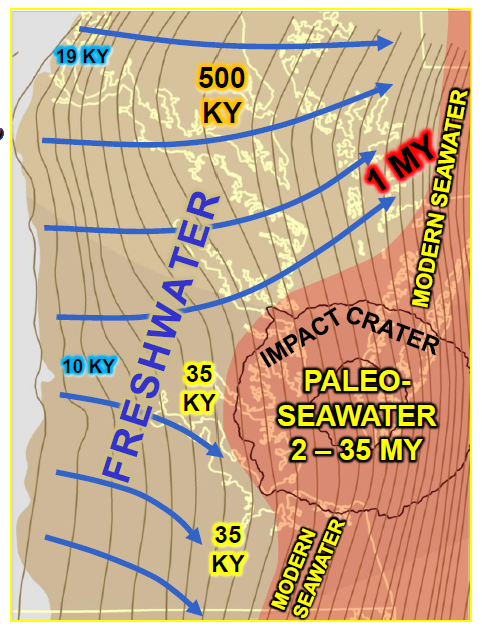
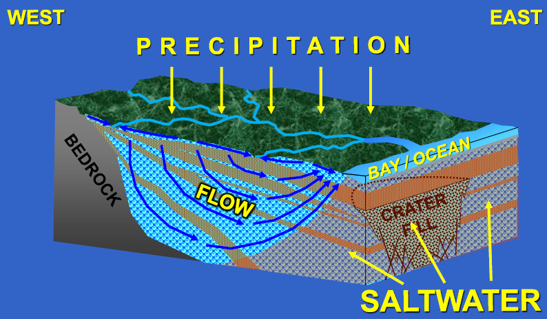
In the 1990's, the discovery of an impact crater in the lower Chesapeake Bay provided a new explanation. The inland saltwater wedge was created when a meteor/comet (bolide) dug a 6,000-foot deep crater 35 million years ago.
Seawater instantly vaporized, creating a brine (1.5 times as salty as normal seawater) that was trapped as debris flung up by the impact quickly re-filled the hole. The impact also cracked the confining layers in sedimentary formations for some distance, providing channels today for seawater to intrude vertically and inland.28
An alternative explanation for the salt wedge was proposed in 2017 by a hydrologist with the U.S. Geological Survey: the bolide landed in an isolated basin of the Atlantic Ocean where the water was 100 to 145 million years old, and the water was already hypersaline when the bolide hit. The hypersaline water was dated by use of helium isotopes, but it is possible that the isotope ratio was altered by helium that reached the surface after the bolide create crack deep in the crust.29
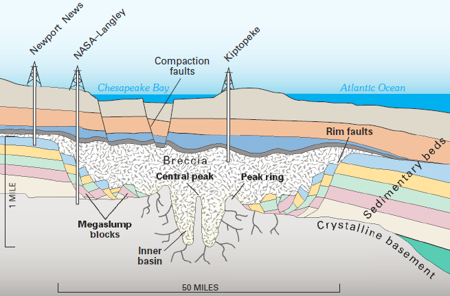
how impact altered sedimentary layers in southeastern Virginia
Source: US Geological Survey, Ground Water in Freshwater-Saltwater Environments of the Atlantic Coast (Figure 17)
In addition to potentially-excessive groundwater withdrawals by municipal drinking water wells, primary concerns in the Eastern Virginia Groundwater Management Area include industrial water use by paper mills at Franklin and West Point, chicken processing plants, and potential facilities supporting offshore energy development in the Atlantic Ocean.
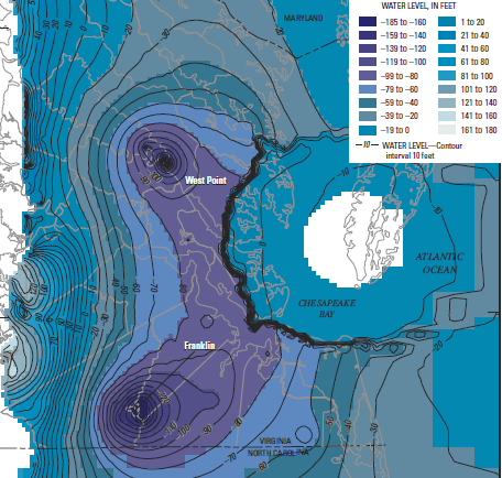
Groundwater withdrawal at the West Point paper mill lowered groundwater levels as much as 100 feet. Extraction of the water created a "cone of depression" with a radius of about 29 miles around the withdrawal point.
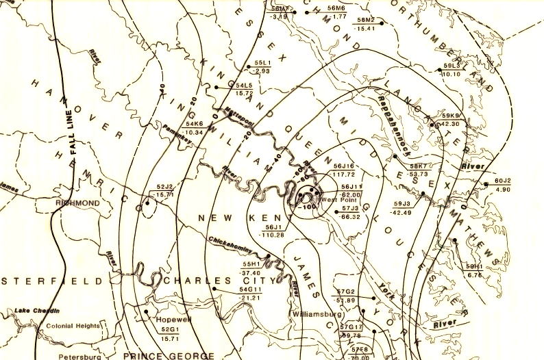
lowered "potentiometric surface" of groundwater caused by withdrawals for paper mill at West Point
Source: US Geological Survey, Potentiometric surface map for the Cretaceous aquifer, Virginia Coastal Plain, Water Resources Investigations Open-File Report 80-965
When the paper mill at Franklin began operating in 1938, the water level in the Potomac Aquifer was seven feet above the land surface; wells were artesian. The US Geological Survey estimated the groundwater flow rate there to be 10 feet per year.
After World War II, industrial withdrawal caused the water level to decline by seven-eight feet per year. Average depth to groundwater at a monitoring well in Franklin dropped to 200 feet, far lower than in other locations away from large-scale industrial withdrawals. At Franklin, the land itself subsided an inch as sediments compacted after groundwater was extracted.
pumping groundwater faster than natural recharge will cause the surface to drop (land subsidence)
Source: US Fish and Wildlife Service, Vanishing Lands - Sea Level, Society, and Chesapeake Bay (Figure 21)
Groundwater levels stabilized in the 1990's after passage by the General Assembly of the Groundwater Management Act of 1973 and an update in 1992. When the paper mill closed briefly between 2010-2012, groundwater levels increased nearby. When operations at the mill resumed, withdrawals were reduced from 30-35 million gallons/day (MGD) to roughly 15 MGD.
Water trapped within sediments of the Potomac Aquifer began to seep back into the gaps between particles within the cone of depression. Water from overlying aquifers also migrated downward. That draining reduced the availability of water for wells that might be drilled into those shallower aquifers.
Groundwater experts calculated that the cessation of mill withdrawals triggered repressurization as much as 50 miles away within one year. That response stopped around 2021, and decline is projected to begin again in the 2030's.30
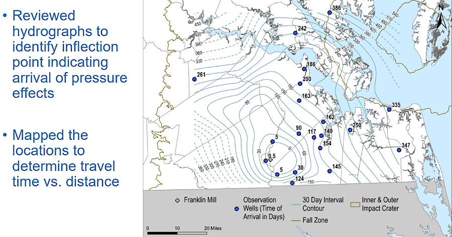
when pumping stopped at the mill in Franklin, the Potomac Aquifer began to repressurize
Source: Virginia Department of Environmental Quality (DEQ), Analysis of 2010 Franklin Mill Closure Pressure Effects
Caroline County, which was heavily dependent upon groundwater sources for municipal and household water, decided to switch to a surface water supply. It finally obtained approval from state agencies in 2026 to withdraw 9 million gallons/day (MGD) from the Rappahannock River. A 35-mile pipeline would carry raw water to serve customers in the towns of Port Royal and Bowling Green, before terminating near Carmel Church.
Much of the controversy over Caroline County's application was associated with the use of eminent domain to acquire the site for the intake facility, and initial plans to provide cooling water to new data centers. The final permit reduced planned withdrawal from 13 to 9 MGD and to authorize only municipal use, precluding industrial use.31
Nationwide, continued reliance on groundwater for industrial, agricultural, and municipal use has extracted more water than rainfall has resupplied. Once-common artesian wells have largely disappeared and pumping is now required, after aquifers have been depressurized.
The Virginia Artesian Bottling Company in Mechanicsville, northeast of Richmond, advertises:32
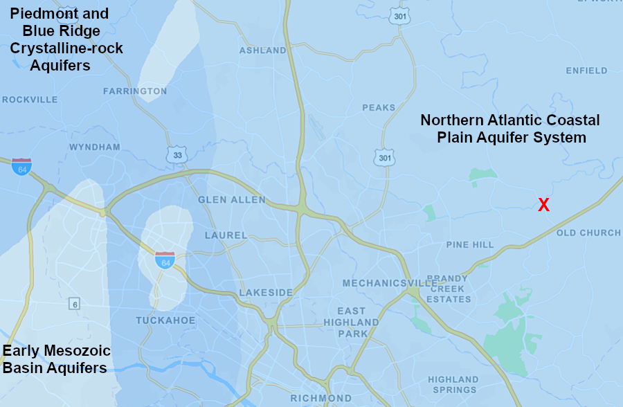
Virginia Artesian Bottling Company in Mechanicsville (red X) draws groundwater from beneath the Coastal Plain
Source: ESRI, ArcGIS Online
The company may have a legitimate claim to the name "artesian" if its wells were in use before the 1950's, or still managed to penetrate a confining aquifer with adequate underground pressure to push the groundwater upward into the pipe. In the Coastal Plain, groundwater pressure was once sufficient to force water from the Potomac Aquifer above the surface and create artesian wells. Withdrawals since the paper mills at Franklin and West Point opened have depressurized that aquifer, and wells must pump water to the surface now.
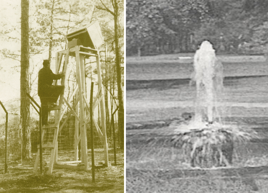
to measure water level changes in 1946 near Franklin, hydrologists built a column at an artesian well - such as the one at Norfolk
Source: US Geological Survey (USGS), 1940s Monitoring Well in Franklin, Virginia; Virginia Department of Environmental Quality (DEQ), Senate Joint Resolution No. 25: Groundwater Supply East of Interstate 95 (April 8, 2026)
A 2023 nationwide study concluded:33
Outside of the two designated Groundwater Management Areas, there are no limits on the volume of groundwater withdrawal. In the Piedmont, the development of data centers after 2020 stimulated concerns that aquifers would be drained for cooling water, though most data centers were using surface water from public utilities or air cooling. A single data center can consume up to 5 million gallons per day MGD) for evaporative cooling. If withdrawn from an aquifer, the 20-40% of water not evaporated would be discharged on the surface and not reinjected underground.
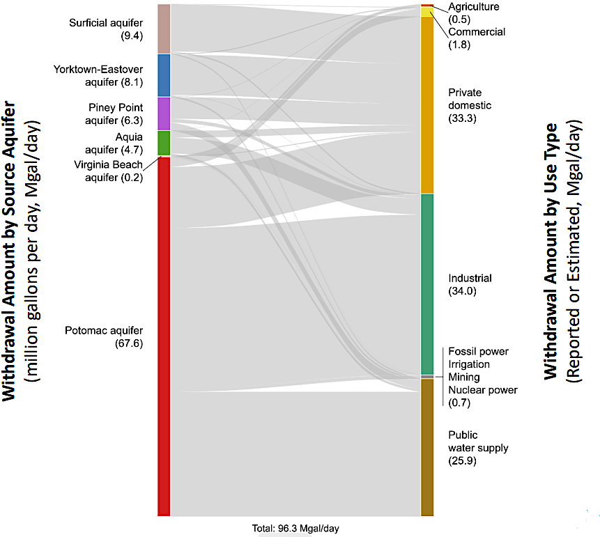
in 2026, 96 million gallons/day were extracted from different aquifers in the Eastern Virginia Groundwater Management Area
Source: Eastern Virginia Groundwater Management Advisory Committee, Meeting Minutes (April 8, 2026)
The saprolite in the Piedmont, which may extend down 100 or more feet, holds more water than the fractured crystalline bedrock underneath. Little research has been done to quantify the amount of water in the saprolite and the rate of recharge; there is little data regarding sustainable/unsustainable use of Piedmont aquifers. Land use debates regarding where to locate data centers almost always include public concerns that large pumping operations to extract groundwater for a new industrial user will cause nearby homeowner wells to run dry.
In 2016, Fauquier County sought assistance from the US Geological Survey (USGS) in completing a Fauquier County Groundwater Resource Assessment and Monitoring Study. A Groundwater-Level Contour Map completed in 2018 indicated that there were no cones of depression; demand on groundwater resources at current withdrawal rates appeared to be sustainable.
The Loudoun County Preservation and Conservation Coalition completed a groundwater study in 2025. Residents in the county relied upon 15,000 private and community wells, as well as surface water delivered by the public utility (Loudoun Water). The report concluded:34
In addition to water supply, the quality of groundwater is a resource management issue. Pollutants on the surface leach into groundwater, especially in karst regions with sinkholes and caves.
Runoff from highway pavement carries gas and oil droplets, metal brake filings, rubber particles from tires, and other contaminants into groundwater aquifers as well as to nearby surface streams. Bacteria from septic systems and animal manure, both livestock and wildlife, also is carried down to the water table. Pesticides, herbicides, and fertilizers applied on farmland ends up in groundwater as well as in adjacent streams. Those contaminants flow underground to reappear at the surface in nearby springs, or in drinking water wells drilled into the aquifer.
In 2011, Augusta County established land use constraints within 23 Source Water Protection Overlay Districts. Restrictions were most severe within 1,000 feet of public water sources, land designated as Area 1. Recharge areas, designated Area 2, allowed more activities but still prohibited injection wells and junkyards.35
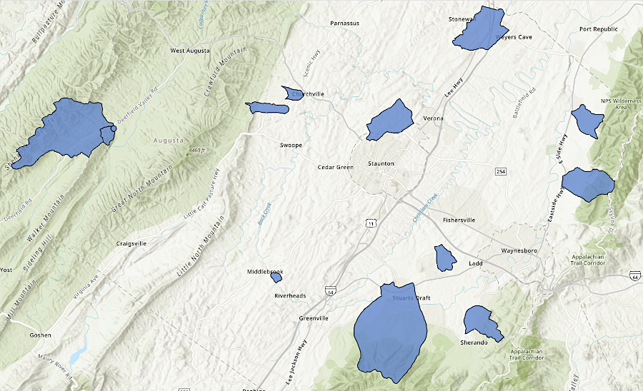
local governments can designate groundwater protection areas and restrict land uses that might pollute aquifers
Source: Augusta County, AugRkbg_Wellhead_Sourcewater_Protection
At the Virginia Beach Oceanfront, excavation of the sandy soils to create the Atlantic Park recreational surf lagoon between 18th and 20th Streets revealed excessively high levels of arsenic and iron. The dewatering process for the the $325 million surf park project stopped until a treatment process was implemented that met Virginia Department of Environmental Quality (DEQ) standards for discharge into Lake Holly. The contamination was thought to come from the former Virginia Beach Civil Center, a geodesic dome auditorium known as "The Dome," which was on that site between 1958-1994.
The city was responsible for remediation of the site. After two years of negotiations, Virginia Beach compensated the developer for the delay and extra costs by paying $3 million and transferring ownership of three additional parcels of land worth $5 million. The parcels, currently parking lots, could be developed as Phase 2 of the Atlantic Park project. Phase 1, which opened in 2025, included an entertainment venue named The Dome.
A 2026 project nearby to install storm, sewer and water infrastructure exposed groundwater contamination which was again at a level which required treatment before discharge. Mitigating the environmental impact added $5 million in costs to the planned $43 million project, an increase of over 10%.36
Source: Prince William Conservation Alliance, Water Water, will there be a drop to drink
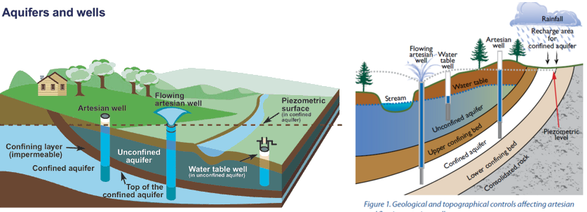
groundwater can reach the surface again via multiple paths
Source: US Geological Survey (USGS), Artesian Water and Artesian Wells and Aquifers and wells
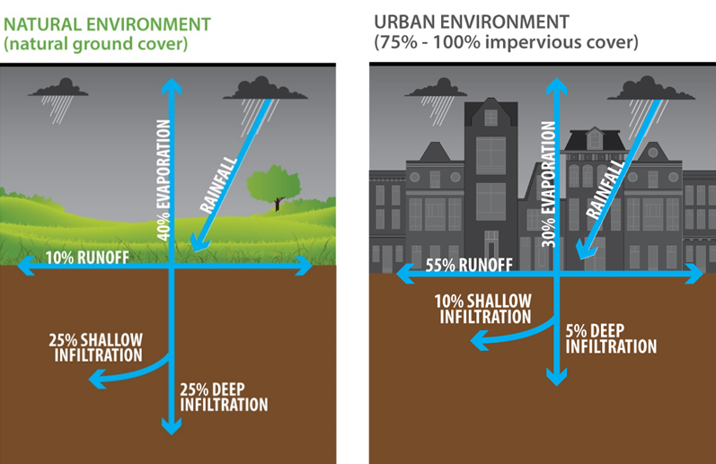
rainwater is blocked from seeping into the ground, when the surface become impervious
Source: District of Columbia Water and Sewer Authority (WASA), DC Clean Rivers Project Overview
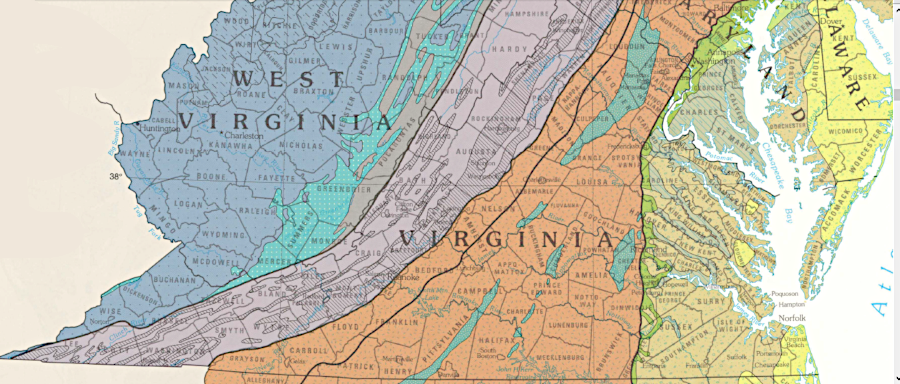
aquifers in Virginia have a different character in different physiographic provinces
Source: US Geological Survey, The Ground Water Atlas of the United States (HA 730-L, Figure 7)
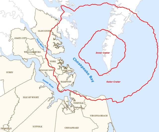
a bolide impact 35 million years ago fractured groundwater aquifers in what is now Hampton Roads/Eastern Shore
Source: Hampton Roads Regional Water Supply Plan (Map 3-6)
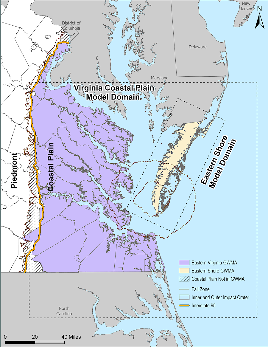
the far western edge of the Coastal Plain is not included in the Eastern Virginia Groundwater Management Area
Source: Virginia Department of Environmental Quality (DEQ), Eastern Virginia Groundwater Management Advisory Committee (December 4, 2025)
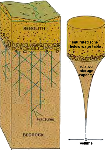
in the Piedmont, the decomposed metamorphic/igneous rocks known as "regolith" stores much more groundwater than the fractures in parent bedrock at greater depth
Source: Preliminary Hydrogeological Assessment - The Binns Tract - Chancellorsville, Virginia
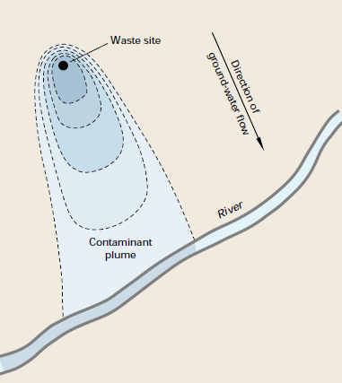
leaking underground storage tanks filled with petroleum products - or cracked septic tanks - can contaminate groundwater and ultimately surface streams
Source: US Geological Survey (USGS), Ground Water and Surface Water: A Single Resource (Circular 1139)