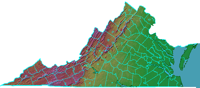
click on a county to get more information
Source: Ray Sterner, Color Landform Atlas of the United States
click on a county to get more information
Source: Ray Sterner, Color Landform Atlas of the United States
There are 95 counties now existing in Virginia. The General Assembly has created subordinate county and city jurisdictions for nearly 400 years, and other counties have been dissolved, converted into cities, or lost to the Northwest Territory, Pennsylvania, Kentucky, and West Virginia. Several of the remaining 95 counties once had different names, and every remaining county has had its boundaries altered at one time or another. 1
Colony-wide government came first, starting with governance centered at Jamestown by the private joint-stock Virginia Company. All legal business, particularly processing distribution of the property in estates after people died, was handled by the Council and President. An appointed governor replaced the President and Council when Lord de la Warre finally arrived in 1610.
In 1617, Governor Sanuel Argall began to decentralize control from Jamestown, He divided the colony into four "incorporations" of James City, Charles City, Henrico and Kikotan (Elizabeth City).
The Virginia Company initiated the Virginia legislature in the "Great Charter" approved by company owners in 1618 at a meeting in London. The General Assembly, with elected representatives from 11 separate settlements and an appointed Council to advise the appointed Governor, first met at Jamestown in 1619.
To reduce the administrative workload on the Governor and Council, in 1622 the legislature created "inferior courts" with commissioners (justices) of the peace in several locations.
The courts authorized licenses for taverns and marriages and were expected to handle other civil affairs. Soon after they were created, Opechancanough led an uprising and the Second Anglo-Powhatan War erupted. Governor Sir Francis Wyatt appointed military commanders to manage defense of different settlements. The commanders organized monthly meetings of male colonists, and civilian affairs were addressed as well as military preparedness at those monthly courts.
In 1632, the General Assembly officially ordered monthly courts to be held at Warwicke River, Warrosquyoke (later Isle of Wight), Elizabeth Citty, and Accawmacke. In 1635, the General Assembly created eight local jurisdictions - James City, Henrico, Charles City, Elizabeth Citty, Warwick River, Warrosquyoake, Charles River, and Accawmack.
The initial eight local jurisdictions were called "shires." In 1642 the General Assembly decided that the monthly courts would be called "countie courts" led by "commissioners of the countie courts."
The concept of a local shire dated back to Anglo-Saxon kingdoms in England in the 11th Century. A king would appoint a "shire-reeve" (sheriff) to collect taxes and make local decisions. by the 14th Century, shires had county court with justices of the peace/magistrates appointed by the king serving as local decisionmakers. That form of local government survived in England until passage of the Local Government Act of 1888.2
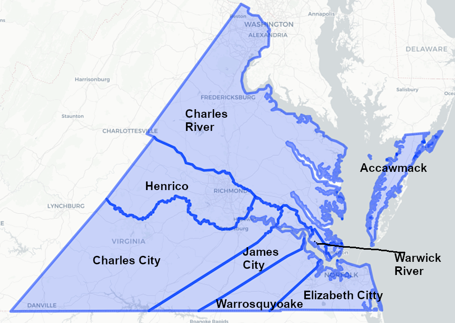
the General Assembly formally established the first eight shires/counties in 1634
Source: Newberry Library, Atlas of Historical County Boundaries
Forming new units of government with county courts helped the legislators offload to others some of the responsibilities/workload for handling land ownership changes, processing wills, and dealing with minor crimes. Similarly, creating parishes with vestry for Anglican churches helped offload the burden of providing social services for the destitute, assigning responsibility for illegitimate children, etc.
After 1634, each county was authorized to elect two members to the General Assembly. Those members sat in the House of Burgesses, once it began to meet as a separate body in 1643. The process mimicked how the 40 counties in England sent two members each to the House of Commons.
Local county officials were appointed by the colonial Governor, with the advice of his Privy Council. Wealthy local landowners administered local justice, appointed local officials such as the county sheriff, and established local taxes. Whenever there was a vacancy on the county court, the other members told the governor which wealthy white man from a respected family that he should appoint as the replacement. There was no opportunity for local residents to vote and establish local priorities, through elections for the House of Burgesses might create a change in the perception of which families had the greatest influence.
Virginia's first state constitution, adopted in 1776, perpetuated the process of the governor appointing all local officials. Not until the Virginia Constitution of 1851 were local residents empowered to vote for members of the county court (and for circuit court judges). The 1851 constitution required each county to be divided into four parts, which equal territory and population, and Justices of the county court were elected to serve four-year terms.
The initial eight counties established by the General Assembly grew to 20 counties by 1680, 50 counties by 1750, and 99 counties by 1800. Up to the American Revolution, the expansion of political authority roughly matched the migration of colonists inland:3
The 1851 state constitution established a process for the creation of new counties. Creation of a new county added two new members to the House of Delegates. If many counties were added west of the Blue Ridge where the population was growing, then Tidewater planters need constitutional protections to ensure they would not lose control and see taxes on slave "property" increased. Westerners needed assurances that the Tidewater planters could not create new counties east of the Blue Ridge just to increase the power of large slaveowners in the General Assembly.4
The 1870 state constitution required that new counties have a population of at least 10,000 people. The 1870 constitution finally established a separation of powers at the local level, creating an executive role for county supervisors and an exclusively legal role for the county court.5
The counties did not unite to create Virginia; the state was not created "from the bottom up" by a vote of independent counties. Instead, the legislature of Virginia created the counties from the top down.
That is a key distinction between the formation of Virginia vs. formation of the Federal government. The US Congress and then an entire structure of Federal government were created from the bottom up. The first 13 states coordinated with each other "in Congress assembled" to unite into one nation.
The only authorities held by local jurisdictions were granted by the legislature. Local governments lack power to make decisions as challenging as land use planning, or as simple as hiring dogcatchers, unless the jurisdiction can identify a specific grant of authority from the General Assembly. Virginia courts interpret the grant of authority according to the Dillon Rule.
Three counties (Chesterfield, James City, and Roanoke) have specific charters from the General Assembly that spell out specific authorities. The rest are empowered to exercise governmental authority based on Title 15.2 of the Code of Virginia.
Elected county supervisors serve as both the legislative and executive branch of local government. The mechanics of overseeing executive operations varies. The majority of Virginia's 95 counties use the County Commission/Traditional system of government, but other forms of county government grant appointed staff different levels of authority. These forms of governance include:6
Urban County Executive - Fairfax County
County Executive - Albemarle, Prince William counties
County Manager Plan - Arlington County
County Manager - Henrico County
County Board - Carroll, Russell, Scott, Grayson counties
County Charter - Chesterfield, James City, Roanoke counties
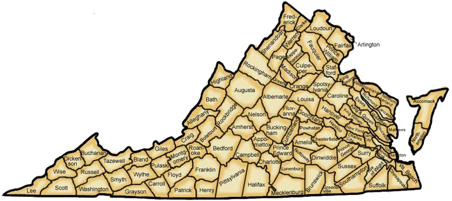
the number has changed over time, but Virginia has 95 counties now
Source: Virginia Department of Education, History and Social Science Standards of Learning (p.8)
The state constitution that went into effect in 1870 established an almost-unique status for Virginia's cities; they are independent from surrounding counties. County residents do not vote in elections for city councils. Within city boundaries, county officials have no responsibility for setting tax rates, zoning land, planning roads, or managing schools. Separate courts handle cases in almost every one of Virginia's 38 cities.
In contrast, towns within Virgia counties remain part of the county. Town residents vote for county supervisors and pay county taxes, as well as vote for town officials and pay town taxes. Town children attend schools managed by county officials. Town officials do have responsibility for land use planning, and with revenue raised from town taxes may hire extra police and offer extra services to town residents.
Some counties and cities share the same name, often confusing people unfamiliar with the independent status of cities. There is a City of Richmond/Richmond County, City of Roanoke/Roanoke County, a City of Fairfax/Fairfax County, and a City of Franklin/Franklin County. Alexandria County changed its name to Arlington County in 1920, to reduce confusion with the City of Alexandria.
There are also counties that share the same name as a town, such as Town of Wise/Wise County. The City of Bedford, which was surrounded by Bedford County, reverted to being a town in 2013.
The confusing status created concerns in 2020. In the campaign for the presidential election that year, President Trump claimed that voting by mail would lead to a fraudulent election and the use of mail-in ballots became a partisan issue. The Center for Voter Information, a non-government organization, mailed out applications for Northern Virginia voters to request absentee ballots, but its printer in Philadelphia included a City of Fairfax return address for the Fairfax County requests. In Roanoke County, return envelopes were addressed to the City of Roanoke election office, Within the city, return envelopes were addressed to the county's election office.7
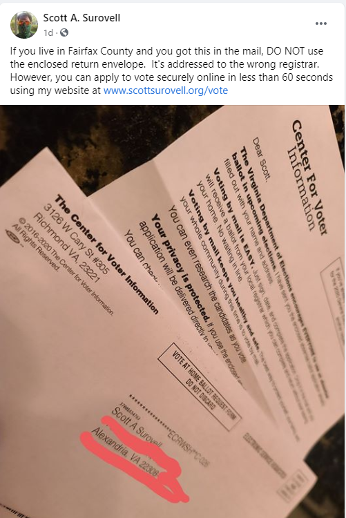
a non-government organization mixed up city and county election offices, when it distributed mail-in ballot applications in 2020
Source: State Sen. Scott Surovell, Facebook post (August 6, 2020)
The last county to be created in Virginia was in Southwest Virginia, which experienced a surge of population growth as the expansion of the railroad network finally make it possible to ship timber and coal to market. Dickenson County was created in 1880.8
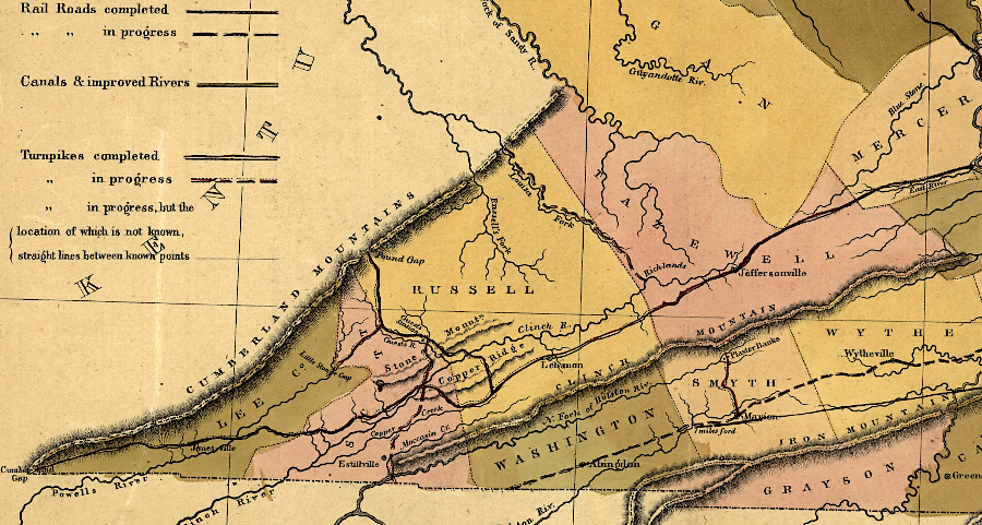
in 1848, before railroads were built, southwestern Virginia had few residents and fewer counties than today
Source: Library of Congress, A map of the internal improvements of Virginia (by Claudius Crozet, 1848)

during the Civil War, historic legal records were destroyed at many Virginia courthouses, including the one in Fairfax County
Source: National Archives, Fairfax Court House, Virginia, ca. 1860 - ca. 1865
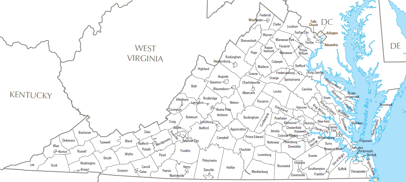
Virginia had 95 counties and 38 cities, after the City of Bedford shifted to town status in 2013
Source: US Geological Survey (USGS) National Atlas, County Map