in 1634, three counties included land on both sides of the James River
Source: Newberry Library, Atlas of Historical County Boundaries
in 1634, three counties included land on both sides of the James River
Source: Newberry Library, Atlas of Historical County Boundaries
Counties in southeastern Virginia were created by the General Assembly starting in 1634. All of Hampton Roads was included in one of the original eight counties.
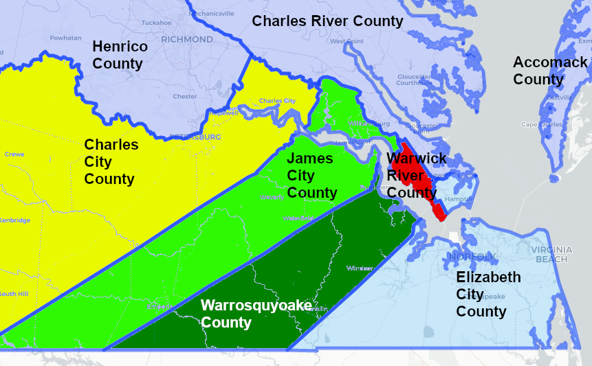
Population growth was concentrated along the James River, As more colonists arrived and the population grew, new counties were created and existing counties were divided. At the end of 1636, that portion of Elizabeth City County south of the James River was split off to form New Norfolk County. A year later, New Norfolk County was divided into Upper Norfolk and Lower Norfolk counties. In 1652, that part of James City County south of the James River was chartered as Surry County. Further upstream, Prince George County was finally carved out of Charles City County in 1703.
by 1703, multiple counties in the Hampton Roads area had been divided to create new local governments
Source: Newberry Library, Atlas of Historical County Boundaries
Three boroughs/towns were chartered in the colonial period - Williamsburg in 1722, Norfolk in 1736, and Richmond in 1742. Norfolk got a charter converting it from a "borough" to a city in 1845. Portsmouth got its city charter in 1858 and Williamsburg became a city in 1884. The General Assembly chartered Newport News as an independent city in 1896. Hampton got a charter that converted it from a town to a city in 1908.
The town of Suffolk became a city in 1910. The new City of South Norfolk was incorporated in 1921. Developers chose to create an independent city, separate from the neighbors of Norfolk and Portsmouth and from Norfolk County as well. Virginia Beach became a city in 1952.1
counties and cities in southeastern Virginia, 1924
Source: David Rumsey Map Collection, Rand McNally Atlas, Virginia
in 1952, Hampton Roads was dotted with eight independent cities between Williamsburg and Virginia Beach
Source: Newberry Library, Atlas of Historical County Boundaries
sevacities1952.png
Governing responsibilities for cities became separate from surrounding counties with adoption of a new state constitution in 1870. The 1902 constitution made clear that cities were completely independent from counties. County officials had no authority within the city's boundaries, and city officials had no authority outside the city boundaries. In contrast, when the General Assembly chartered a town in southeastern Virginia, residents remained part of the surrounding county. Town residents got to elect a mayor and a town council, but they voted for members of the county's Board of Supervisors as well. Town residents also got to pay property taxes to both the town and the county.
Resolution of conflicts between cities and counties was difficult when elected officials in each jurisdiction chose to focus on just their own narrow interest. Local residents often commuted from houses in a county to jobs in a city, creating a need for roads and trolleys that crossed political boundaries and required coordinating construction and maintenance. Cities that developed reliable drinking water systems were asked to supply businesses and residents who lived outside the city's boundaries.
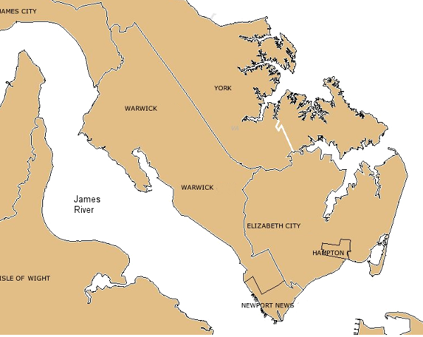
When four square miles of Warwick County were incorporated to form the City of Newport News in 1896, the southeastern portion of Warwick County was cut off from the rest of the county. The neighborhoods known as the North End and the East End of Newport News were originally within Warwick County. Providing services to the city's first suburbs cost Warwick County money, but the property taxes from the high-value railroad and shipyard went to the City of Newport News.
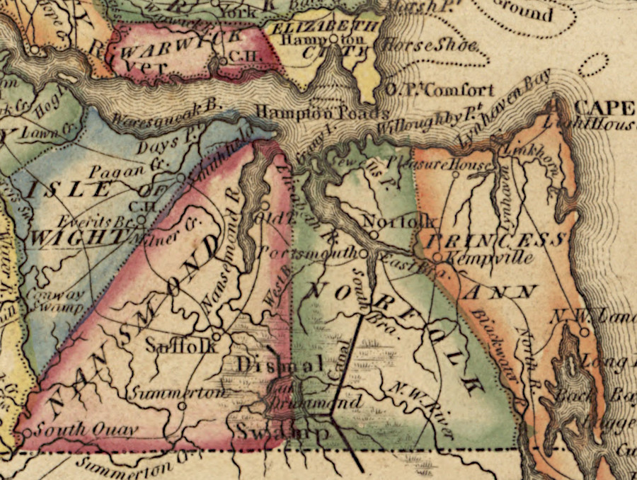
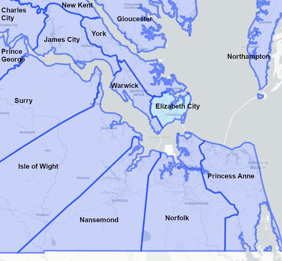
a map produced before 1820 shows the now-extinct counties of Warwick, Elizabeth City, Nansemond, Norfolk, and Princess Ann
Source: Library of Congress, A new and elegant general atlas, containing maps of each of the United States (by Samuel Lewis, 1817?)
The population in Southeastern Virginia grew rapidly with urbanization after Newport News was selected as the major embarkation depot for sending troops to Europe in World War I. Rapid population growth in Hampton Roads continued after World War II, as the Air Force expanded Langley Air Force Base and the Navy expanded multiple installations in the region.
The population boom triggered local land use decisions to permit new subdivisions, new strip commercial centers along highways, and new suburban malls outside city boundaries. Development on the edge of the cities of Newport News and Hampton erased once-clear boundaries between urban/rural jurisdictions. Annexations by the cities transferred land and voters away from county officials, and typically the parcels "lost" to the city had generated higher-than-average property taxes for the counties.
Elected officials in once-rural counties, places that traditionally provided few government services, were forced to make suburban planning decisions. The challenges of choosing where to build new roads, schools, and water/sewer systems were exacerbated by the fragmented approach and competitive attitudes of separate city and county jurisdictions. Racial segregation was required by Virginia laws into the 1960's, and the high percentage of non-white residents within the cities exacerbated political differences with the counties.
The stress of coping with rapid development revealed parochial thinking and counter-productive rivalries between different jurisdictions. Only rarely did multiple jurisdictions unite to take advantage of opportunities to build cost-effective public infrastructure.
In Hampton Roads, competition and conflict were relieved by only occasional cooperation and substantive partnerships between jurisdictions. Proposals by cities to annex tax-generating areas of counties were viewed as "land grabs" by county officials. Virginia's unique separation of cities and counties created a zero-sum game, since annexation of land by a city removed voters and tax revenue from the county.
World War II demonstrated how the Federal government could use its authority to implement large initiatives without excessive delay. Consolidation of fragmented jurisdictions in Hampton Roads would allow comparable efficiencies in regional efforts, by eliminating the potential for a single jurisdiction to block a proposal.
Regional leaders with a long-range perspective, especially from large corporations where worker residences and jobs were in different jurisdictions, sought regional rather than local solutions. Those leaders anticipated "build out" of small rural counties in Hampton Roads, as farmland and forests were converted to residential and retail uses. If the fragmented jurisdictions took a regional approach with coordinated long-term planning to provide services for new development, new infrastructure would cost less.
One simple way to eliminate jurisdictional conflicts was to merge different jurisdictions, eliminating the artificial boundaries created by the General Assembly between cities and counties. Consolidation would also prevent the piecemeal dismemberment of counties by cities, as population expanded and the cities annexed land to provide a full set of city services.
The most ambitious proposal to consolidate was in 1950. Voters in Elizabeth City County, City of Hampton, Town of Phoebus, City of Newport News, and Warwick County were asked to approve merger into a new City of Hampton Roads. All jurisdictions except Hampton approved the proposal, but the rejection n Hampton killed the deal.
In 1952, Elizabeth City County and the Town of Phoebus merged with the City of Hampton. That same year, Warwick County converted into the City of Warwick. Having two cities on its boundaries blocked any future efforts by the City of Newport News to annex county territory.
Regional leaders made another effort in 1956 to create a unified government on the eastern end of the Peninsula, to be called "Port City." Voters in the three independent cities were asked to approve consolidation. Newport News and Warwick voters endorsed the proposal, but Hampton (now enlarged with residents of the former Elizabeth City County) voted it down again.
jurisdictional boundaries on the tip of the Peninsula were more fragmented prior to the consolidation of the City of Hampton with Elizabeth City County/Town of Phoebus in 1952, and the separate merger of Warwick County with City of Newport News in 1958
Source: Newberry Library, Historical Census Browser
After the voters in Hampton narrowly rejected the 1956 proposal, Warwick and Newport News merged two years later. That 1958 merger combined into one jurisdiction the shipbuilding job center of Newport News with the housing of the shipyard workers in Warwick County. The tax base of Newport News could finance expansion of the suburbs into Warwick County. Consolidation streamlined the decision process and reduced costs for providing urban services, especially construction of schools, drinking water plants, and wastewater facilities.
The merger of the City of Warwick into the City of Newport News was a controversial issue in 1958, even though voters in those two jurisdictions had endorsed consolidation proposals in 1950 and again in 1956. As described by Newport News:2
In addition to Newport News and Hampton, Poquoson is the third independent city on the eastern edge of the Peninsula. Poquoson became a separate town within York County in 1952, and got a city charter in 1975. The General Assembly was preparing to impose a moratorium on the creation of new cities in 1975. Poquoson, like Manassas and Manassas Park, chose under deadline pressure to become an independent city.
Status as a town had allowed Poquoson to retain its high school. The only high school in York County was established there in 1910, but by 1952 the county was proposing to build a new high school in a more-central location. Creating a separate town with its own school system kept a high school in Poquoson, and also allowed Poquoson to manage the desegregation process. Today, there is still a very clear distinction in the demographics of Poquoson vs. the rest of the political jurisdictions in southeastern Virginia.3
| Jurisdiction | "White alone" (2010 Census) |
|---|---|
| City of Poquoson | 95% |
| York County | 77% |
| City of Newport News | 49% |
| City of Hampton | 43% |
Poquoson split from York County and became an independent city in 1975
Source: US Fish and Wildlife Service, Wetlands Mapper
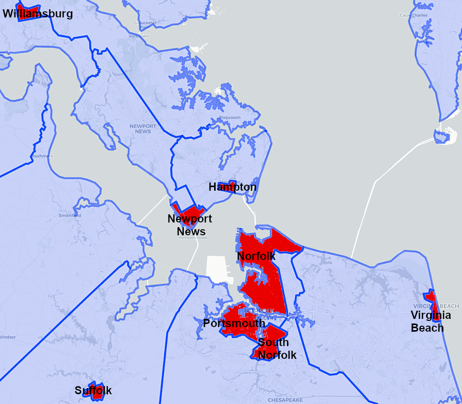
South of the James River, population growth was concentrated in Portsmouth and Norfolk through World War I. Norfolk annexed the town of Berkeley, south of the Eastern Branch of the Elizabeth River, in 1906. In 1921, a separate City of South Norfolk was incorporated.
Conversion of counties to cities was largely a reaction against expansion efforts by the City of Norfolk. It was the dominant jurisdiction in Hampton Roads up to World War II, when Newport News expanded. The population of Norfolk grew from 144,332 to 213,513 between 1940 and 1950, but expansion of the city boundaries was opposed by its neighbors.4
Rural areas surrounding Norfolk, with a low percentage on non-white residents, were not inclined to join into a voluntary metropolitan partnership. Rural county residents would have to contribute extra taxes for development of urban services which would benefit non-whites in the city of Norfolk.
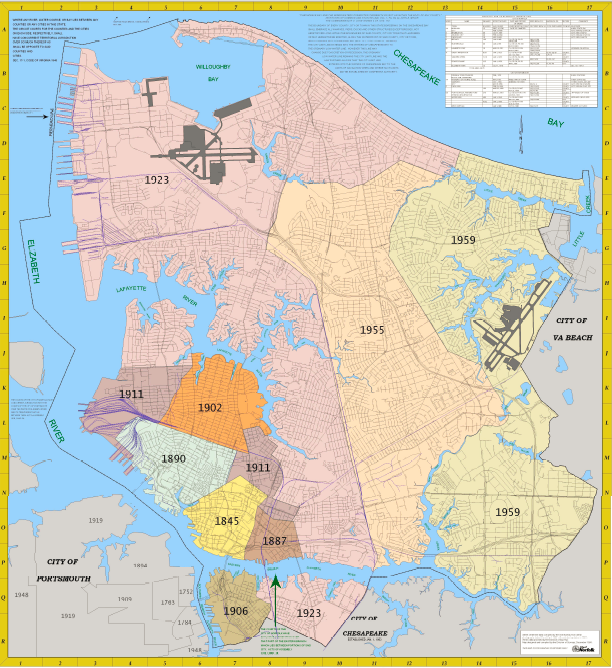
pattern of Norfolk's growth through annexations, 1845-1959
Source: City of Norfolk Map Gallery
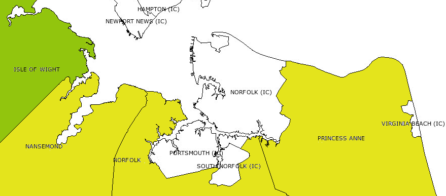
Norfolk had almost twice the population of the surrounding counties in 1950. Only 42,277 people lived in Princess Anne County (now the city of Virginia Beach) and 110,371 people lived in the City of South Norfolk and Norfolk County (now combined into the City of Chesapeake).5
Since a regional agreement was not a political possibility south of the Jams River, Norfolk city officials sought to annex land from adjacent counties. Annexation would increase the city's tax base, since real estate and property taxes from the annexed land would flow into the city's bank account and finance additional services. The city was especially interested in annexing commercial property that had already been developed.
Surrounding counties saw annexation by the city of Norfolk as a threat. Shopping districts and office buildings generate taxes, but do not require many services. In particular, commercial property does not require building and staffing expensive schools for students. After annexation, the counties would end up with less tax revenue but with no significant reduction in the costs of county operations. If Norfolk succeeded in annexing commercial property, then elected officials in the counties would have to raise taxes of the remaining residents to deliver on campaign promises to offer additional services.
Norfolk succeeded in annexing a portion of Princess Anne County in 1955, and again in 1959. The surrounding counties responded by incorporating as independent cities. Following the example of the City of Warwick, they obtained a status which made them immune to any additional annexations by Norfolk.
In 1963, the city of South Norfolk and Norfolk County merged to create the City of Chesapeake. Princess Anne County merged that same year with the town of Virginia Beach to form the City of Virginia Beach.
As independent cities, Virginia Beach and Chesapeake were immune to annexation by Norfolk. The power to resist annexation gave Virginia Beach leverage when Norfolk proposed changes in land use along the boundary. For example, in 2014 Norfolk planned to convert the city-owned Lake Wright Golf Course into an outlet mall, but 38 acres of land owned by the city were located within the jurisdiction of Virginia Beach. Norfolk was obliged to negotiate a rezoning of its land by Virginia Beach officials, who sought to get Norfolk to build road improvements before rezoning land to allow a parking lot.6
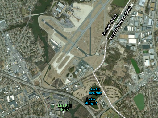
Norfolk was forced to negotiate with Virginia Beach as a co-equal city, in order to convert the Lake Wright Golf Course south of the airport into the Simon Premium Outlet Park
Source: ESRI, ArcGIS Online

in 1907, Norfolk was a thriving port city and Princess Anne County was a rural farm area (with a small beach resort on the Atlantic Ocean shoreline)
Source: Perry-Castaneda Library Map Collection - Virginia Historical Topographic Maps, Norfolk
Urbanization continued to spread in Southeastern Virginia throughout the 1960's. In 1972, Nansemond County converted into the city of Nansemond, eliminating the potential of Suffolk to expand its boundaries over the objections of Nansemond officials. In 1974, the City of Nansemond merged into the City of Suffolk. As co-equal cities in 1972, the benefits of consolidation could be evaluated without the win-lose issues which were always part of annexation disputes.
As a result of the conversions between 1952-1974, all political jurisdictions in Southeastern Virginia are independent cities now; there are no counties remaining. Since towns exist only within counties, there are no towns in Southeastern Virginia neither.
Further consolidation has been proposed after 1974. A 1979 study of the benefits from merging Newport News and Hampton revealed that savings would be roughly 1% of the city budgets. That was not significant enough to justify the headaches of combining and choosing a name for the consolidated city.7
since 1960, land once classified as counties (yellow) has shifted to city status as the independent city of South Norfolk consolidated with Norfolk County to form the City of Chesapeake, the independent city of Virginia Beach consolidated with Princess Anne County to form the City of Virginia Beach, and Nansemond County converted into the City of Suffolk
Source: Newberry Library, Historical Census Browser
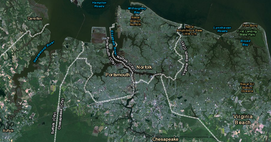
Norfolk is hemmed in today by incorporated cities on all sides, and has no opportunity to expand by annexing land from an adjacent county
Source: US Fish and Wildlife Service, Wetlands Mapper