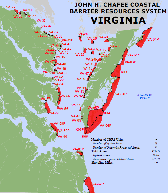
Coastal Barrier Resources System units in Virginia are on both sides of the Chesapeake Bay, as well as along the Atlantic Ocean
Source: US Fish and Wildlife Service, Coastal Barrier Resources System
Coastal Barrier Resources System units in Virginia are on both sides of the Chesapeake Bay, as well as along the Atlantic Ocean
Source: US Fish and Wildlife Service, Coastal Barrier Resources System
Two Federal programs limit development along coastal shorelines in Virginia. Section 404 of the Clean Water Act limits the ability to dredge and fill wetlands.
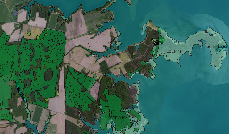
Federal laws limit the development potential of land mapped as wetlands near the Chesapeake Bay in Northumberland County, including Dameron Marsh
Source: US Fish and Wildlife Service (FWS), Wetlands Mapper
In 1982, Congress passed the Coastal Barrier Resources Act (CBRA), and excluded some properties from the Federal Emergency Management Agency (FEMA) National Flood Insurance Program. The law blocked issuance of new federal flood insurance policies within the Coastal Barrier Resources System (CBRS) created by that law.
The intent was to minimize Federal support for new development in undeveloped areas:1
Federal flood insurance enables landowners to rebuild after a storm, and allows developers to construct houses close to the ocean. Through disaster relief and food insurance funding, taxpayers have ended up subsidizing rebuilding on the same sites after multiple storms. The intent of providing relief after a natural disaster ended up becoming a subsidy for building structures at high-risk locations, whereas private insurance rates would have deterred development through high premiums.
The US Fish and Wildlife Service was given responsibility for designating lands above mean high tide with low-density development (less than one structure per five acres) and without roads, sewers, etc. The Federal agency defined 584 separate units of the Coastal Barrier Resources System, where no Federal funds would be awarded to build new infrastructure or support loans for new houses.
Landowners and mortgage lenders today can use a Federal Emergency Management Agency Flood Insurance Rate Map (FIRM) to see which parcels qualify for insurance, or are no longer eligible because they are now within a Coastal Barrier Resources System unit.
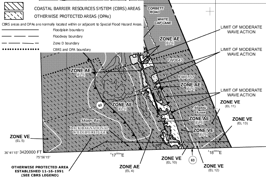
the boundary of the Coastal Barrier Resources System unit at Back Bay is identified by a dotted line on the Flood Insurance Rate Map
Source: Federal Emergency Management Agency, Flood Insurance Map 5155310210G - Virginia Beach
There are no Federal bans on developing parcels of private land included within the Coastal Barrier Resources System. Landowners can still build houses according to local zoning and building codes. However, there are no Federal subsidies for developing land within the Coastal Barrier Resources System. In particular, there are no Federal funds for building roads or other infrastructure, and no subsidized flood insurance or disaster assistance after a storm.
The former executive director of the nonprofit Wetlands Watch summarized the light-handed approach to constraining new development:2
The purpose and extent of the Coastal Barrier Resources Act of 1982 were defined in Section 2 and Section 3 of the law:3
The law was modified eight years later with the Coastal Barrier Improvement Act of 1990, eliminating the requirement that undeveloped coastal barrier consist of "unconsolidated sedimentary materials" and the exclusion of areas that theoretically were already protected before the 1982 law. By 2023, there were 588 System Units with nearly 1.4 million acres of land and associated aquatic habitat.
There are also 282 “Otherwise Protected Areas,” a category of coastal barriers that are mostly held for conservation and/or recreation purposes that include an additional 2.1 million acres of land and associated aquatic habitat.
In Virginia, 64 units were defined affecting nearly 164,000 acres. There were 51 System Units with private land, and 13 Otherwise Protected Areas where all or most land was owned by public agencies and new development was already limited. Back Bay Unit VA-62P was designated as an Other Protected Area, and includes Back Bay National Wildlife Refuge and False Cape State Park.
After Hurricane Sandy in 2012, a remapping project recommended adding 280,000 acres to the Coastal Barrier Resources System. In Virginia, 14 new units were proposed, with 11 of them being completely new and three including acres already classified as part of the system. One of the 64 units was proposed for deletion. Overall, changes were recommended to 60 of the 64 existing units.
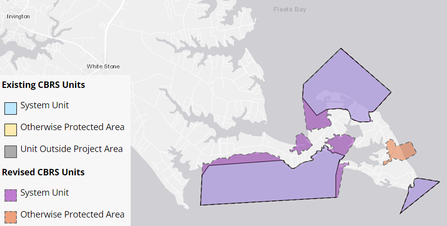
after Hurricane Sandy in 2012, 96,000 additional acres in Virginia were recommended for inclusion in the Coastal Barrier Resources System
Source: US Fish and Wildlife Service, CBRS Projects Mapper
In the final 22 remapping recommendation:5
the proposed expansion of the Coastal Barrier Resources System in 2022 requires action by the US Congress to go into effect
Source: US Fish and Wildlife Service, Report to Congress: John H. Chafee Coastal Barrier Resources System Hurricane Sandy Remapping Project (p.xii)
In 2023, U.S. Rep. Jen Kiggans introduced legislation to add 96,000 acres to the Coastal Barrier Resources System in Virginia. Her legislation was HR5490, the Bolstering Ecosystems Against Coastal Harm Act (BEACH Act).6
Federal expenditures for beach replenishment, visitor centers, and other projects is permitted in Otherwise Protected Areas, but Federal flood insurance is still prohibited.
The boundaries of the units reflect the objective of Congress that existing development would not be affected retroactively by passage of the Coastal Barrier Resources Act in 1982, but that new development in high-risk areas would not be subsidized by the Federal government. If developers had already invested in building a road with a reinforced road bed, a wastewater disposal system, electric service, and a fresh water supply for a planned subdivision, then that land was excluded from the Coastal Barrier Resources System and new houses qualified for Federal flood insurance subsidies.
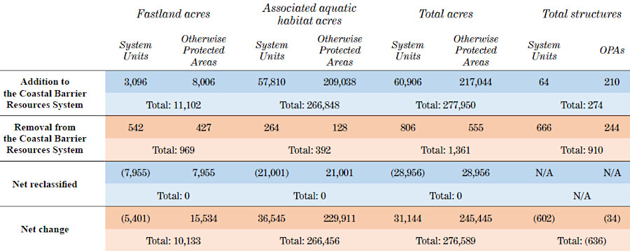
houses on Willoughby Spit still qualify for Federal flood insurance
Source: Federal Emergency Management Agency, Flood Insurance Map 5101040009H - Norfolk
The discrete boundaries of the units do not follow just topographic boundaries. The geometric shapes reflect the pattern of property boundaries as well as flood risk.
Large areas of the shoreline were already developed prior to passage of the law, and not included within any Coastal Barrier Resources System unit. Parcels in the resort portion of Virginia Beach, Willoughby Spit in Norfolk, and Chincoteague Island are still included on the Flood Insurance Rate Maps (FIRMs) used by Federal Emergency Management Agency to calculate flood insurance rates.
However, permits from the Corps of Engineers and the Virginia Marine Resources Commission are required before modifying tidal wetlands along the Chesapeake Bay or the Atlantic Ocean, even outside the boundaries of Coastal Barrier Resources System units.
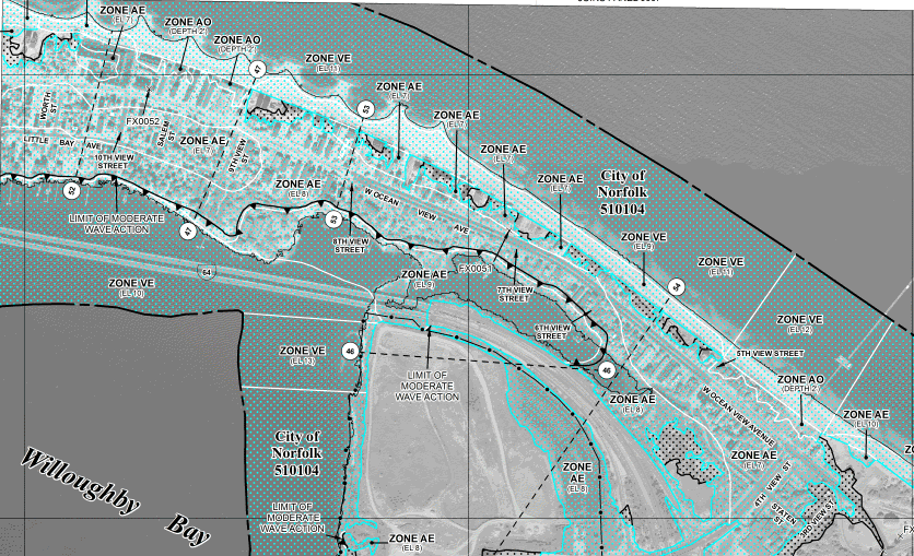
already-developed properties, such as Chincoteague Island, were excluded from the Coastal Barrier Resources System when it was first created in 1982
Source: US Fish and Wildlife Service, Assateague Island Unit VA-01P (1 of 2)
The Coastal Barrier Resources System does not prohibit new development or alter local zoning. Landowners can build new structures on parcels within the boundaries of units designated by the US Fish and Wildlife Service - but without access to the Federal flood insurance program managed by Federal Emergency Management Agency, property owners are reluctant to build structures where county zoning might allow more development.
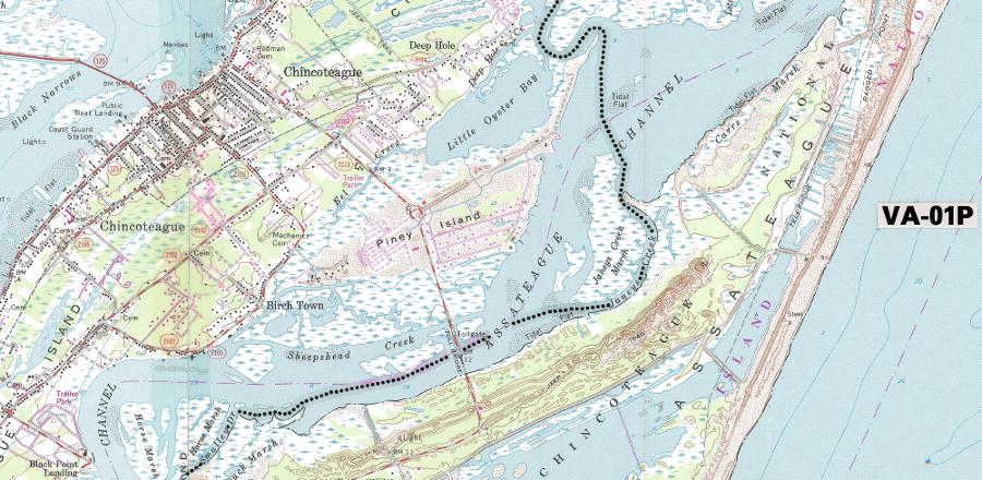
boundaries of Elbow Point Unit (VA-29) and White Point Unit (VA-30) reveal how little of the land on the shoreline was included in Coastal Barrier Resources System units
Source: US Fish and Wildlife Service, Coastal Barrier Resources System Mapper, Elbow Point Unit (VA-29) and White Point Unit (VA-30)
The exact boundaries of Coastal Barrier Resources System units are significant. A parcel located just outside a unit can have a much higher value than a parcel included within the unit.
Every five years, the US Fish and Wildlife Service is required to review maps and update the boundaries to reflect changes caused by natural forces such as erosion and accretion, voluntary additions to the Coastal Barrier Resources System by property owners, and additions of excess Federal property to the system. Otherwise, an act of Congress is required to modify unit boundaries, even to correct technical mapping errors.7
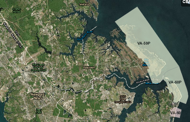
Plum Tree Island Unit VA-59A is designated as an Otherwise Protected Area in the Coastal Barrier Resources System
Source: US Fish and Wildlife Service, Coastal Barrier Resources System Mapper