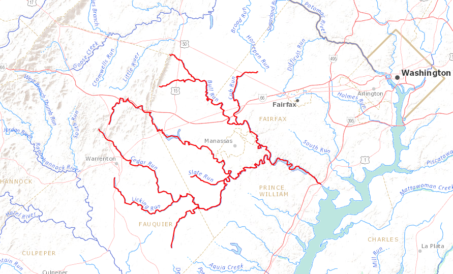
Occoquan River tributaries include Bull Run
Source: US Geological Survey (USGS), Streamer
Occoquan River tributaries include Bull Run
Source: US Geological Survey (USGS), Streamer
The ancestral Appalachian Mountains were uplifted around 300 million years ago during the creation of Pangea. When the African tectonic plate crushed slowly into the North American tectonic plate, pressure from Africa broke off a slice of hard bedrock from the edge of North America. Tectonic forces thrust that slice westward around 40 mile in what is now Northern Virginia.
That slice was initially covered by other material piled on top as Pangea formed; what is now the Blue Ridge was buried. Rrosion has been etching away ever since the ancestral Appalachian Mountains were uplifted. In the last 250 million years, perhaps five miles of bedrock has been eroded and carried downwind/downstream. Throughout the process, river channels have etched into the mountains as water helped to level them. Once the supercontinent broke up around 200 miillion years ago, rivers flowed eastward into the new and expanding Atlantic Ocean.
The initial Occoquan River may have formed as soon as the tectonic plates began to separate. It could have begun as a narrow channel cutting down into the ice fields located on top of the 20,000 foot high mountains. If so, the ancestral Occoquan River would date back to the Triassic Period, when dinosaurs were beginning to dominate life on land.
More likely, today's Occoquan River is much younger. It is certain that some rivers formed as North America separated from Africa as the Mid-Atlantic Ridge gradually began to force the continents apart. Rivers carried sediments downstream into the Atlantic Ocean as soon as Pangea split apart, but as the mountains were lowered and the landscape changed the pathways of those rivers also shifted.
As the ancestral Appalachian Mountains eroded away, different rock formations in various watersheds dissolved at different rates. The streams flowing off the mountains in different watersheds altered their routes, as land eroded away and some streams cut down through softer/fractured bedrock faster than others. The deeper streams captured more water flowing downhill because of gravity, and in the process of "stream piracy" some rivers became larger than others.
In the last 10-30 million years, as erosion finally exposed the slice of hard bedrock that had been broken off the edge of North America, the Blue Ridge began to evolve. Initially, streams flowing west to east continued to cut into the bedrock, creating narrow canyons. Then a large river flowing north on the west side cut deeper into the softer limestone, shale, and sandstone formations on the west side. Streams quit flowing eastward through the canyons; instead, they were "pirated" by the larger river as it created the Shenandoah Valley. Gaps through which streams once flowed became watershed divides, with tiny trickles of water starting at the top and draining to the east and the west. The water gaps ended up as modern wind gaps.
Erosion on the east side was also faster than on the hard Blue Ridge bedrock. Streams flowing off the Blue Ridge joined to create the ancestral Rappahannock River. Further north, other streams created the ancestral Occoquan River and a pre-Potomac River than flowed only east of the mountains.
The ancestral Appalachians may have eroded to almost a flat peneplain at some time over the last 200 million years. Sometime in the last 50 million years, that peneplain was uplifted by tectonic forces and the modern Appalachhians were created. Erosion attacked the bedrock again with new energy due to the uplift, creating the modern topography. The common height of most ridges in West Virginia today show how the once-flat peneplain was lifted up; on the Allegheny Plateau, rivers have scratched out their valleys in (geologically speaking) recent times.
About 5 million years ago, the pre-Potomac River finally cut through a weak spot in the Blue Ridge at modern Harpers Ferry, in another example of stream piracy. That new gap in the Blue Ridge diverted water which had been flowing north. The extra flow into the Potomac River helped it cut a deeper channel, and today the Occoquan River is a tributary of the larger stream.
The modern headwaters of the Occoquan River are two streams that start on the eastern side of the Blue Ridge. One tributary, Broad Run, has etched its way beyond the eastern flank and drains the western edge of Fauquier County. Broad Run has created Thoroughfare Gap separating Bull Run Mountain on the noth from Pond Mountain on the south. Thoroughfare Gap is at the same latitude as Manassas Run, which carved through the western flank of the Blue Ridge. Together, they created a route from the Shenandoah Valley to the Potomac River that was used by the Manassas Gap Railroad in the 1850's and is now followed by I-66.
The western end of the other major tributary, Bull Run, starts at Cold Spring Gap in Bull Run Mountain. Catharpin Creek, which drains into Bull Run, eroded slightly deeper into the Blue Ridge and drains Jackson Hollow north of Hopewell Gap.
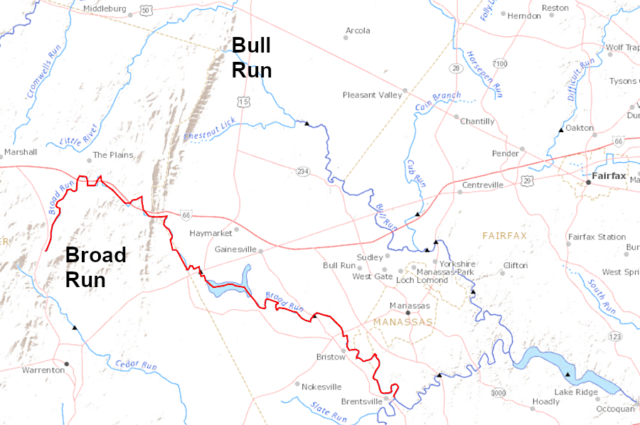
the Broad Run tributary of the Occoquan River has etched a path further westward than the Bull Run tributary
Source: US Geological Survey (USGS), Streamer
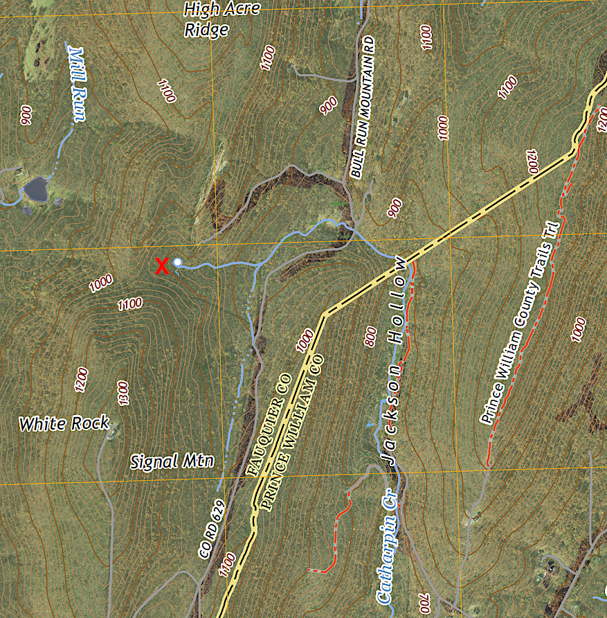
the headwaters of Catharpin Creek are in Fauquier County, west of Jackson Hollow on Bull Run Mountain
Source: US Geological Survey (USGS), Middleburg 1:24,000 topographic quadrangle (2022)
When Paleo-Indians first reached the Occoquan River 15-20,000 years ago at the end of the last Ice Age, sea levels were 400' lower. The Occoquan River flowed into the Potomac River, which was not tidal. The Potomac River was narrower at the time, as it flowed downstream to meet the Susquehanna River. There was no Chesapeake Bay, and no Belmont Bay.
English colonists and enslaved Africans began to clear the natural forests in the Occoquan River watershed starting in the 1670's. The dominant land use was farmland, particularly dairy farms supplying milk to Washington DC, until World War I. Growth of the Federal government led to a population boom that started in Alexandria and Arlington, then expanded into Fairfax County. Expansion of Federal employment during World War II and the Cold War led to further suburban expansion into Prince William and Loudoun counties.
The transformation of the landscape altered stormwater runoff. Impervious surfaces blocked rainwater from infiltrating into the ground and recharging underground aquifers.
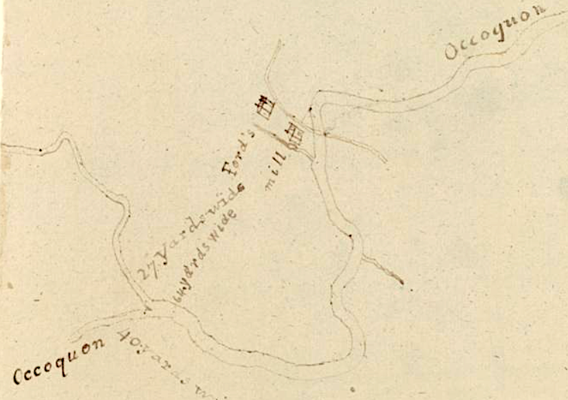
the width of the Occoquan river at its confluence with Bull Run was measured in 1820
Source: Library of Virginia, A Survey of Bull Run and Occoquon (by Andrew Alexander, 1820)
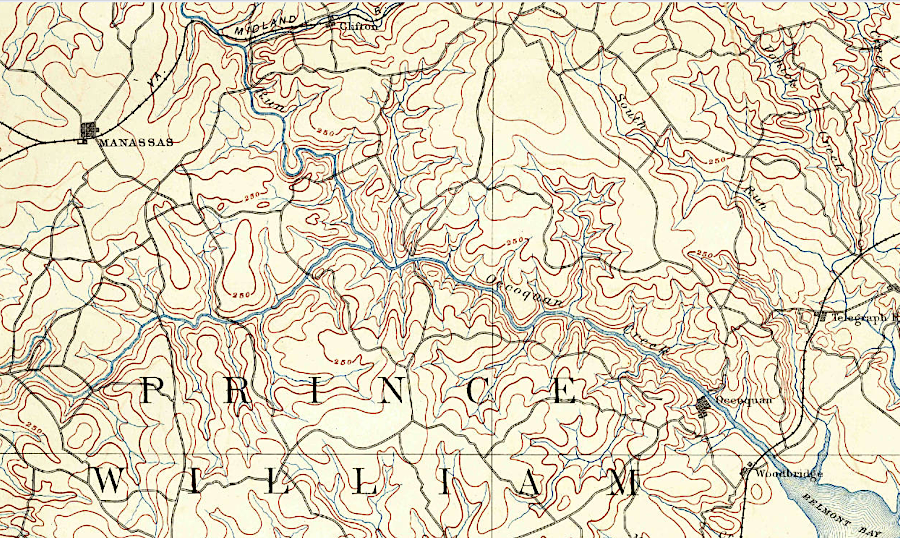
in 1890, the Occoquan River watershed was almost entrely forest and farmland
Source: US Geological Survey (USGS), Mt. Vernon Va 1:125,000 topographic quadrangle (1890)
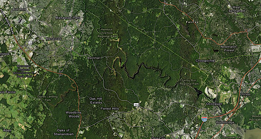
in 2022, much of the Occoquan River watershed in Prince William County was covered by an impervious surface
Source: ESRI, ArcGIS Online
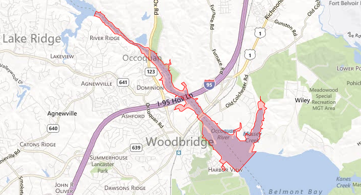
area downstream that could be affected by a disastrous break of Occoquan Dam
Source: Occoquan Dam Siren, Impact Zone Map

in 1951, Alexandria Water had not constructed its two dams and removed Ryons Dam yet - and the US Geological Survey described the Occoquan as a "creek" rather than as a "river"
Source: US Geological Survey (USGS), Occoquan 1:24,000 scale topographic map (1951)
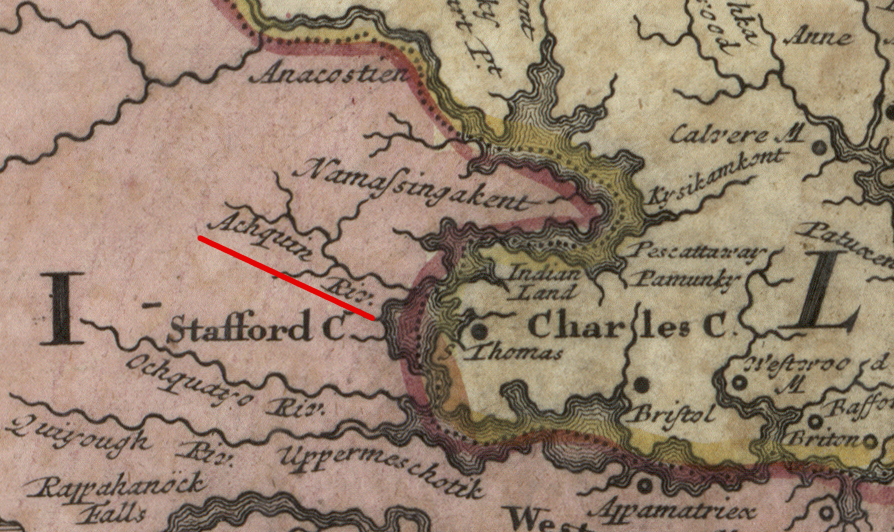
the Achquin (Occoquan) River in 1714
Source: Library of Congress, Virginia, Marylandia et Carolina: in America septentrionali Brittannorum industria excultae (by Johann Baptist Homann, 1714)
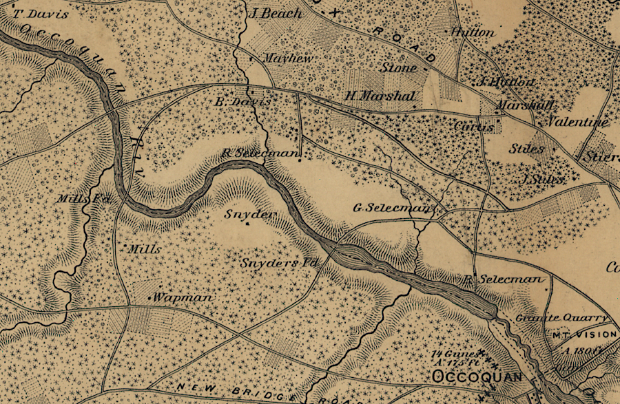
a Civil War map suggests there was a mill dam upstream of the Town of Occoquan
Source: Library of Congress, Map of n. eastern Virginia and vicinity of Washington ("McDowell Map," 1862)
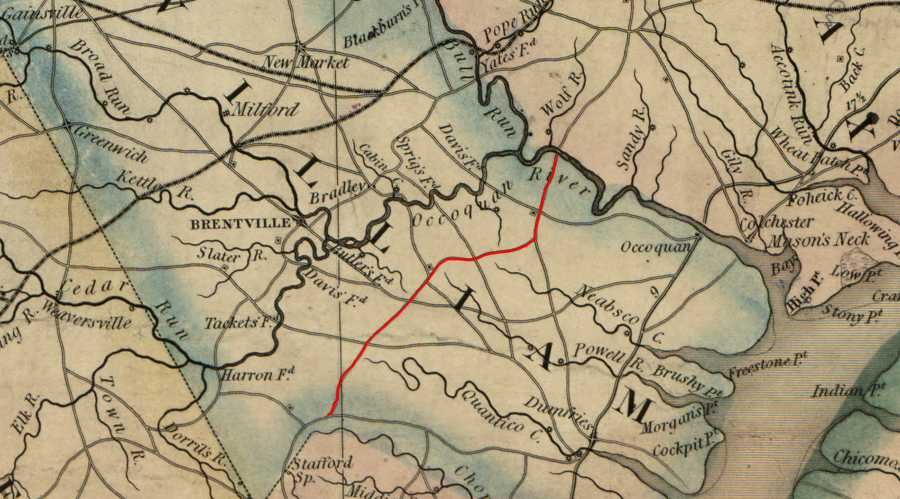
in the colonial era, road viewers in Prince William County were conscious of the watershed divides when constructing what is today Hoadley Road to the ford across the Occoquan River at Wolf Run Shoals
Source: Library of Congress, A map of the state of Virginia, constructed in conformity to law from the late surveys authorized by the legislature and other original and authentic documents (1859)

the French army marched north from Yorktown in 1782, and camped at Colchester on the Occoquan River
Source: Library of Congress, Amérique campagne (1782)