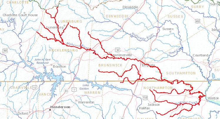
the Meherrin River flows through the Virginia Piedmont to the Chowan River, south of the Virginia-North Carolina border
Source: US Geological Survey (USGS), Streamer
the Meherrin River flows through the Virginia Piedmont to the Chowan River, south of the Virginia-North Carolina border
Source: US Geological Survey (USGS), Streamer
The headwaters of the Meherrin River are in Charlotte County. The North, South, and Middle forks flow southeast across the saprolite formed from the metamorphic bedrock in various geologic terranes that were squeezed onto the edge of Virginia in the Taconic and Appalachian orogenies. On the Piedmont, the river channel has eroded in multiple places to crystalline bedrock that is 300-500 million years old.
Downstream of the Emporia Dam at the Fall Line, the Meherrin River flows through the sediments of the Coastal Plain. On the Coastal Plain, the river flows on top of unconsolidated sediments that were deposited in "high stands" of the Atlantic Ocean during the Pleistocene and Pliocene epochs over the last five million years.
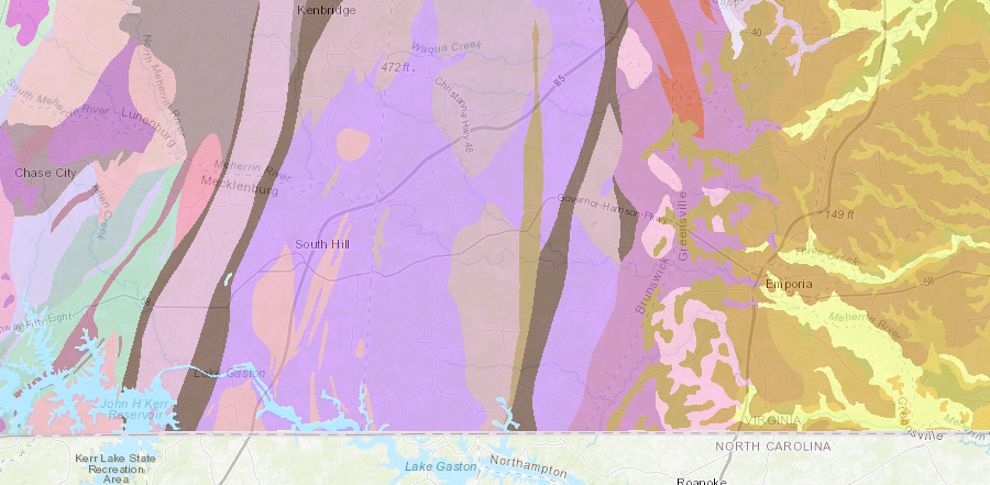
the Meherrin River flows across geologic terranes that were accreted to the continent in the Taconic and Alleghenian orogeny, then from Emporia eastward crosses younger Coastal Plain sediments
Source: Virginia Department of Mines, Minerals, and Energy (DMME), Geologic Map of Virginia (1993)
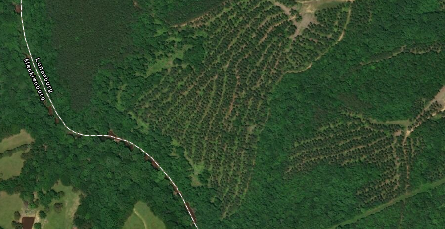
There is some topographic relief along the river, and exposed outcrops of unmodified bedrock in the riverbed.
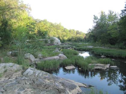
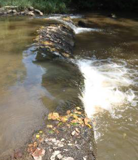
exposed outcrops in the bed of the Meherrin River include "Big Rock" (left) and a natural rock shelf at Union Mill (right)
Source: Virginia Department of Conservation and Recreation (DCR), Meherrin Scenic River Report: Mecklenburg County and Lunenburg County (p.8, p.9)
In 1865, General Sheridan led Federal forces south across the Meherrin River in order to force the last Confederate army in North Carolina to follow General Robert E. Lee's example and surrender. Gee's Bridge, where he crossed, had been destroyed in 1864. The Union army had to build new bridges for the supply train wagons to cross and continue south down the Boydton Plank Road, because the river banks leading down to the ford were not passable.
The Quartermaster Department described the Meherrin then as:1
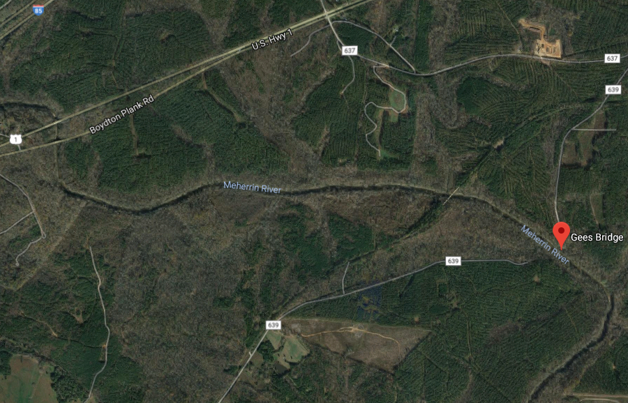
General Sheridan and his forces crossed the Meherrin River at Gees Bridge, after General Lee surrendered at Appomattox
Source: Google Maps
The Meherrin River has no geological knickpoint comparable to Nottoway Falls, but there are some small rapids. Starting in 1756, a dam at what is now called Whittle's Mill provided the necessary "head" so falling water could provide the mechanical energy needed to turn the wheel. The first mill was located where a quartzite ledge created a small natural rapid in the Meherrin River.
Over time, the river provided waterpower to 35 mills. Different mills were constructed at the site known as Whittle's Mill, and they continued in operation for the longest period of time.
the first dam at Whittles Mill, where State Route 636 now crosses the Meherrin River, was built in 1756 to create the "head" needed for turning a waterwheel
Source: ESRI, ArcGIS Online
Fortescue Whittle purchased the mill and replaced the original log crib dam. In 1809, he had enslaved workers excavate quartzsite blocks next to the site on the Lunenburg County side and use them to build a stone dam on top of the original one. Whittle replaced the mill that was located on the northern bank with a new building on the southern bank.
Whittle's Mill dam was raised five feet higher around 1920, using local cobbles and concrete. The new owner installed two turbines in 1920 to generate electricity, which he used to power a new mill that was constructed outside of the flood plain.
Despite the move, the massive 1940 flood destroyed all the mills on the Meherrin River, including the Whittle's Mill in its new location. The mill was rebuilt, but that structure burned in 1955. The mill was not replaced and the hydroelectric system was abandoned. In the 1970's, a small engineering firm refurbished the turbines and generators, and sold electricity to the investor-owned utility Virginia Electric and Power Company (VEPCO).
The hydroelectric system was abandoned a second time in the 1980's. One of the original 1920 turbines was refurbished again in 2010, and it now generates electricity that is sold to the utility.
In the 1950's, the town of South Hill built a pipeline from a point just downstream of the mill and began to use the Meherrin River as its water supply. The 1809 dam with its 1915 addition had survived the 1940 flood, but a portion finally collapsed and the millpond drained on June 27, 1962. The next year, South Hill bought the property.2
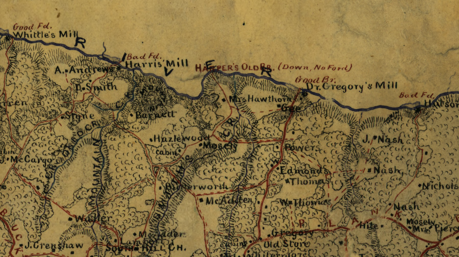
the status of bridges and the quality of fords across the Meherrin River were mapped by Confederate engineers in 1864
Source: Library of Congress, Map of Mecklenburg Co., VA (Confederate Engineer Bureau, 1864)
West of Keysville, most streams drain into the Roanoke River. US 15 runs roughly along the watershed divide in the northern half of Charlotte County.
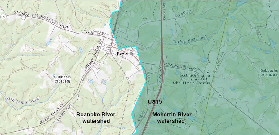
US 15 in northern Charlotte County marks the watershed divide between the Roanoke and Meherrin rivers
Source: US Geological Survey (USGS), NHD View
In Mecklenburg County, Highway 47 runs along the Roanoke River-Meherrin River watershed divide between the Charlotte County line and the town of South Hill.
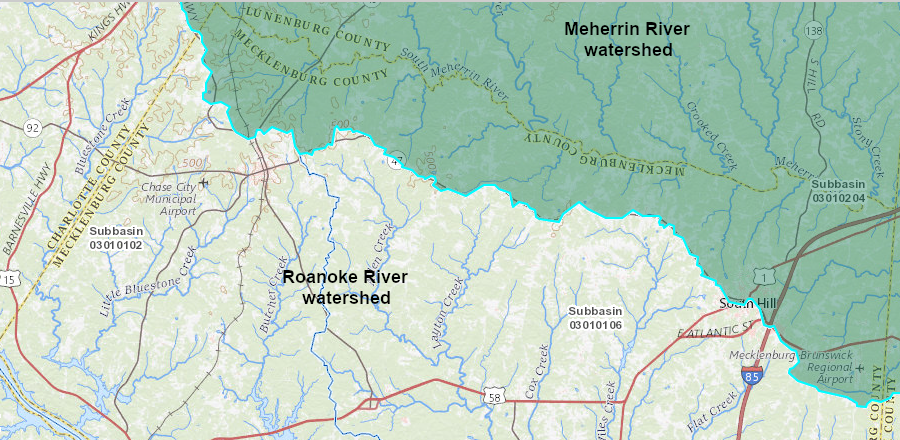
Highway 47 in Mecklenburg County marks the watershed divide between the Roanoke and Meherrin rivers
Source: US Geological Survey (USGS), NHD View
The watershed divide on the north edge of the Meherrin River drainage basin, separating it from the Appomattox River basin in Dinwiddie and Nottoway counties, is defined by US 460.
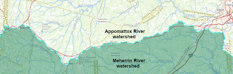
the Appomattox River is the Appomattox River is north of US 460 and drains to the Chesapeake Bay, but the Meherrin River drains to Albemarle Sound
Source: US Geological Survey (USGS), NHD View
Unlike the Appomattox River, the Meherrin River is outside of the Chesapeake Bay watershed; its water ends up in the Albemarle Sound. The mouth of the Meherrin River is in North Carolina. By the time it reaches the confluence with the Chowan River, elevation has dropped from about 660 feet at Keysville in Charlotte County to sea level.
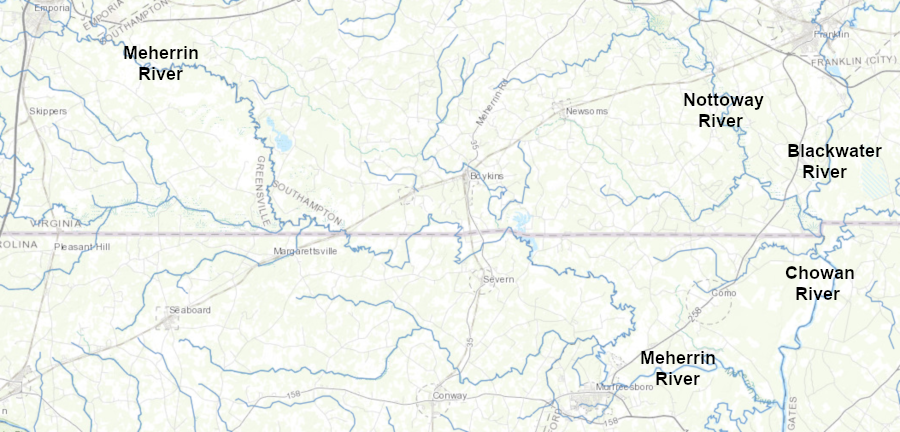
the Meherrin River flows into North Carolina before joining the Chowan River east of Murfreesboro
Source: ESRI, ArcGIS Online
In part because the Meherrin River does not flow to the Chesapeake Bay, English colonists were slow to settle in the area. The Occaneechi trading center on the Roanoke River was destroyed in Bacon's Rebellion in 1676.
In 1714, after the Tuscarora War, Governor Spotswood arranged for the creation of Fort Christanna on the south bank of the Meherrin River. His goal was to create a new trading post and frontier fort 65 miles from Williamsburg.
Consolidation of the remnants of the Tutelo/Saponi/Occaneechi tribes would simplify trading with the Native Americans in the Piedmont of Virginia and North Carolina, and allow easier oversight in one centralized location. Spotswood calculated it would be less expensive to support Fort Christanna, including a school for Native American children, than to pay for the "rangers" who patrolled the countryside and theoretically protected both colonists and the tributary Siouan-speaking Indians from Iroquois raiders.
Spotswood's rivals blocked his efforts to benefit personally through the Virginia Indian Company monopoly of the fur trade at Fort Christanna. After Iroquois raiders succeeded in attacking a group of visiting Catawba in 1717, the General Assembly blocked approval of more funds for the fort. In 1729, the last of the Saponi living along the Meherrin River moved to join the Catawba in North Carolina.
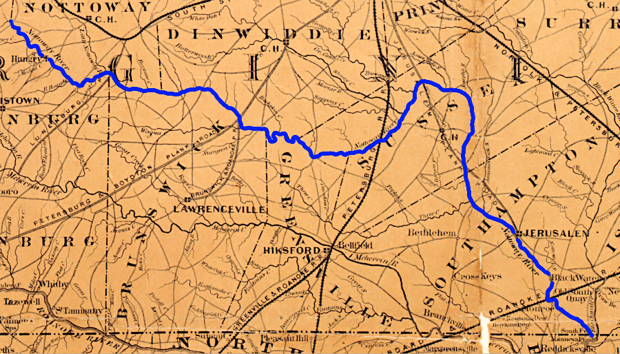
the limited navigability of the Meherrin River was overcome by roads and railroads to Petersburg and Portsmouth prior to the Civil War
Source: Library of Congress, Colton's new topographical map of the eastern portion of the state of North Carolina with part of Virginia & South Carolina (by Joseph H. Colton, 1861)
Today, the Virginia Department of Game and Inland Fisheries maintains interpretive signs at the Fort Christanna Historical Site.3
the Meherrin River starts in Mecklenburg County at the confluence of the North Meherrin and South Meherrin rivers
Source: ESRI, ArcGIS Online
In much of the watershed, the dominant modern land use is timber management.
the Meherrin River watershed is largely forested, with much land dedicated to commercial tree farms
Source: ESRI, ArcGIS Online
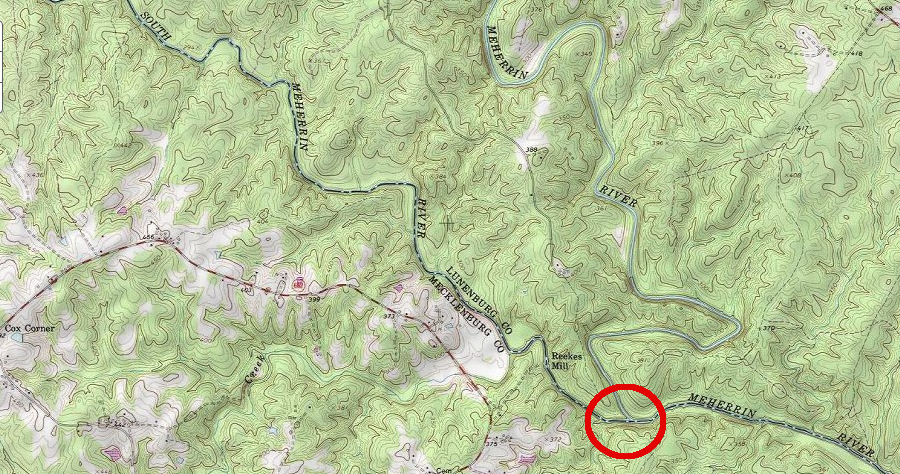
Along the 35 miles in Brunswick County, less than a dozen houses are visible. Riverbank vegetation obscures the remains of an old sand mining operation upstream of the Union Mill bridge, where Route 138 now crosses the river. Tourism officials describe the Meherrin as "Southside Virginia's Hidden River."
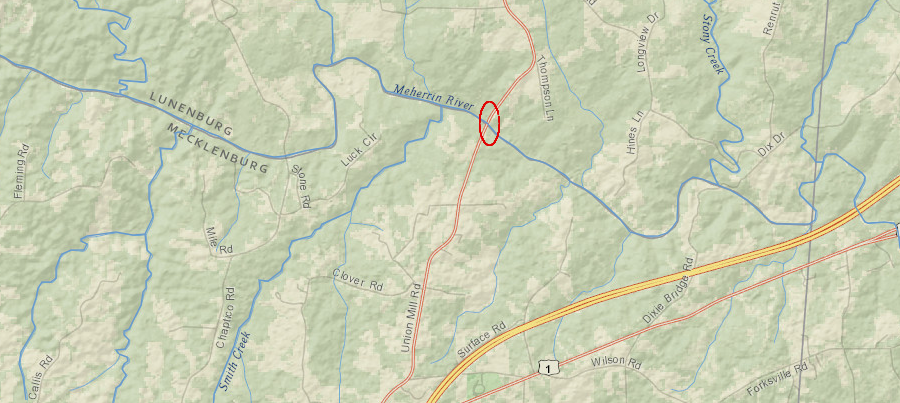
Route 138 crosses the Meherrin River near the site of the old Union Mill
Source: ESRI, ArcGIS Online
The only major settlement on the banks of the river is the city of Emporia, on the Fall Line. The Emporia Dam there has a fish lift, but still blocks anadromous fish (striped bass, American shad, hickory shad, alewives or blueback herring) from getting upstream.
The Roanoke Logperch (Percina rex) in the Meherrin River is classified by the US Fish and Wildlife Service as an "endangered" species. The fish is also found in in widely separated segments of the upper Roanoke, Pigg, Smith, and Nottoway rivers.
Construction of the Roanoke Rapids, Gaston, Kerr, Leesville, Smith Mountain, and Philpott reservoirs in the Roanoke River basin altered habitat dramatically, reducing populations of the Roanoke Logperch to low levels. On the Meherrin River, almost of the mill dams have been washed away over time. Only the Emporia Dam and the dam at Whittle's Mill still convert free-flowing river habitat into impoundments.4
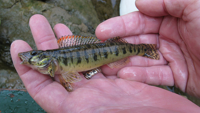
the Roanoke Logperch is an endangered species found in the Meherrin River
Source: US Fish and Wildlife Service, Roanoke logperch
The Meherrin River is also home to two species of fresh-water mussels, the Atlantic Pigtoe (Fusconaia masoni) and the Yellow lampmussel (Lampsilis cariosa).
A 7.5 mile stretch of the North Meherrin River, from the Route 712 Bridge downstream to the confluence with the South Fork, was designated by the General Assembly as a State Scenic River in 1997. Designation restricts development of water-impounding dams, and allows local tourism officials to highlight the river as a recreational asset. Local support is required before the elected officials in the state legislature will designate all or part of a river as a State Scenic River.
In 2006, the General Assembly designated 37 miles of the Meherrin River through Brunswick County, from the Lunenburg county line to the Greensville county line, as a State Scenic River. In 2013, the 18-mile stretch shared by Brunswick and Lunenburg county was added. That last designation connected the two separate designated sections. A boater starting at the Route 712 bridge could now float over 62 miles downstream on waters designated as a State Scenic River.5
The Virginia Department of Conservation and Recreation (DCR) has classified the remaining stretch of the Meherrin River, from the boundary of Brunswick-Greensville counties downstream to the North Carolina line, as a "potential" State Scenic River.6
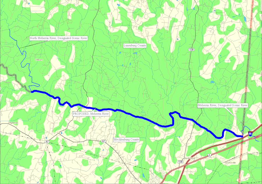
in three stages, over 62 miles of the North Meherrin River and Meherrin River have been classified as a State Scenic River
Source: Virginia Department of Conservation and Recreation (DCR), Meherrin Scenic River Report: Mecklenburg County and Lunenburg County (p.5)
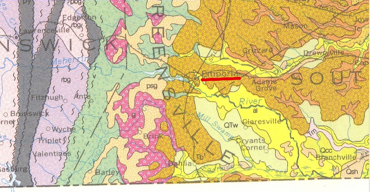
the Meherrin River crosses the Fall Line west of Emporia, flowing eastward from hard crystalline Piedmont bedrock to soft sediments of the Coastal Plain
Source: US Geological Survey (USGS), National Geologic Map Database, Geologic Map of Virginia (1993)