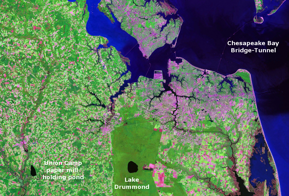
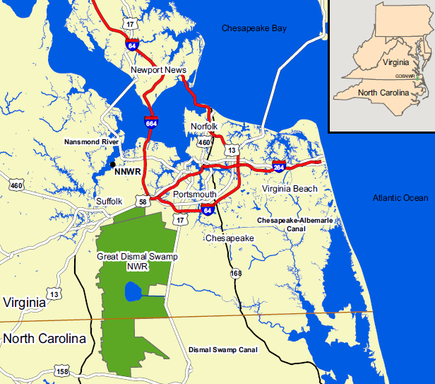
southeast Virginia, showing Lake Drummond and Union Camp holding ponds to west (at City of Franklin, near Blackwater River)
Source: NASA, Stennis Space Center
southeast Virginia, showing Lake Drummond and Union Camp holding ponds to west (at City of Franklin, near Blackwater River)
Source: NASA, Stennis Space Center
Lake Drummond is one of just two natural lakes in Virginia. The origin of the lake is still a mystery. Multiple theories have been advanced, including that the lake was created by a meteor/comet impact, a fire which burned a deep hole in the peat soil, or steady winds after the last ice age that create an elevated barrier of sand which blocked normal drainage.
The extraterrestrial formation theory is no longer accepted in scientific circles. Though Carolina bays have shapes that resemble impact craters on other planets and the moon, the sediments at the bottom of the bays remain horizontal and intact. If meteor or ice fragments had struck the surface of the Earth, blasting out the Carolina bays and forming shallow depressions, then the sediments still remaining within the bays would have been disrupted.
Lake Drummond probably started as one of many thermokarst lakes on the Coastal Plain during the last 50,000 years as an ice sheet covered much of North America. Steady winds during the winters froze the sandy ground. During the summers, wind scooped shallow depressions after sand thawed.
Summertime rains formed lakes within the depressions, and then the winds spurred currents that moved the sandy sediments into elliptical forms. Wetlands with many bay trees formed in what European settlers called "Carolina Bays." One thermokarst lake may have expanded into a larger-than-average lake after a wildfire burned through the peat, excavating a hole that accommodated a more-than-average amount of water.
Lake Drummond was named for William Drummond, who was the first colonist to discover the lake while hunting in 1663. Governor William Berkeley of Virginia, one of the eight Lords Proprietors to whom King Charles II had granted the new colony of North Carolina in 1663, appointed Drummond to serve as governor of the Albemarle section.
In 1672 Drummond irritated Berkeley after being chosen to build a fort at Jamestown to protect against the Dutch. Construction was so slow, and of such poor quality, that the governor had Drummond arrested for failure to peform the job. In 1676 Drummond, by then an enemy of Berkeley, chose the wrong side in Bacon's Rebellion - so Lake Drummond is named after an insurrectionist who sought to overthrow the official government.
After Nathaniel Bacon died and the 1676 insurrection collapsed, William Drummond was captured and brought to Governor Berkeley for punishment. The governor's last words to him supposedly were:1
The ground surrounding Lake Drummond includes dry land as well as what early colonists called "dismal" or swampland. People have hunted, fished, and gathered food within the swamp since the Paleo-Indians arrived around 18,000 years ago.
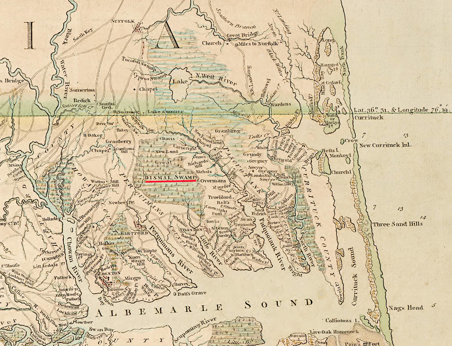
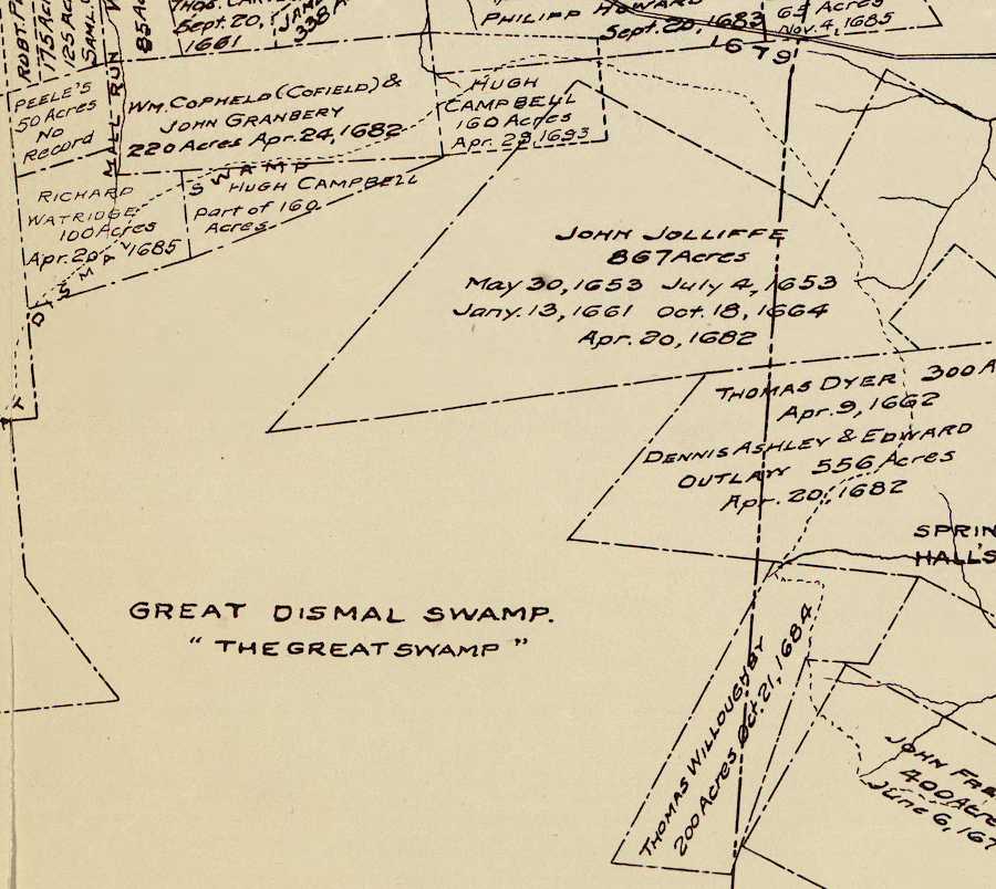
the Dismal Swamp extended south into North Carolina to the headwaters of the Perquimans River
Source: University of North Carolina, A Compleat map of North-Carolina from an actual survey (by John Collet, 1770)
When European colonists arrived, they occupied the sites of Native American villages along the Elizabeth and Nansemond rivers. Some of the original residents moved permanently into the recesses of the swamp. Living away from the rivers limited mobility and access to food, which is why there were no Native American towns in the swamp when the colonists arrived. Isolation was preferred because it provided more security, more control over when to contact/hide from the settlers.
Enslaved people also fled into the swamp. Some were captured, some died, but some fugitives successfully escaped their pursuers. Native Americans and escaped enslaved people created permanent "maroon" communities on the islands of dry land, living out of sight of the settlers except when trading was desired. After Bacon's Rebellion in 1676, the Native Americans moved away and the maroon communities were composed predominantly of African-Americans.
The swamp did not experience the settlement pattern for the rest of colonial Virginia. Wealthy members of the gentry did not patent parcels of a few hundred or a few thousand acres, then carve out smaller pieces to sell to new immigrants or indentured servants who had served their time.
The swampland was too wet to farm except in scattered isolated hummocks. Those sites attracted the outliers of society, not the traditional farmers. In 1714 the governor of Virginia, Alexander Spotswood, called the swamp a "No-man's-land" and complained that "Loose and disorderly people daily flock" to them.
In 1728, William Byrd II led the Virginia team that surveyed the colonial boundary between Virginia and North Carolina. The paths through the swamp were too confusing for him, so he ended up traveling around its northern edge to meet up with the surveyors on the other side. Byrd found the wetlands and the local residents to be so depressing that he wrote in his diary that rum was a necessity.
Byrd noted that the surveyors heading into the swamp "which no body before ever had either the Courage or Curiosity to pass" carried packs loaded with eight days of food, weighing 50-60 pounds. He also recorded that the jug of rum quickly grew lighter on the journey. The Virginia and North Carolina commissioners appointed by the colonial governors retreated from the swamp and went around it on drier ground, but the surveyors had to walk:2
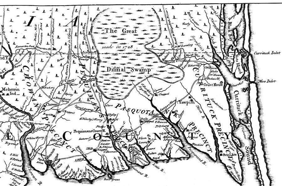
the creation of the Carolina colony split the Dismal Swamp, and the unclear boundary helped the swamp become a refuge for indentured servants and slaves who escaped from their masters
Source: East Carolina University, New and Correct Map of the Province of North Carolina (by Edward Moseley, 1733)
After the success of Uncle Tom's Cabin, Harriet Beecher Stowe wrote Dred: A Tale of the Great Dismal Swamp to highlight how the Great Dismal Swamp had became a refuge for enslaved people. A former resident of a maroon community described why people chose to live there until the Civil War led to the end of slavery:3
the Dismal Swamp was a destination on the Underground Railroad, prior to the Civil War
Source: National Park Service, Network to Freedom Map
The dry land is typically peat (dead vegetation that has not decomposed yet, or been compressed into lignite/coal) with sand underneath. Such soil is unsuitable for agriculture, but Atlantic White Cedar (Chamaecyparis thyoides) used to thrive in places high enough for plant roots to grow above the water table. Other common species were black gum (Nyssa sylvatica), bald cypress (Taxodium distichum), water tupelo (Nyssa aquatica), and red maple (Acer rubrum).
Atlantic White Cedar is a pioneer species, capable of regrowing from seed after fires/storms and forming dense stands. It is not an "old growth" species that replaces itself, perpetuating cedar forests indefinitely. Without disturbance, other species such as red maple ultimately dominate land originally covered by Atlantic White Cedar trees.
As one researcher noted:4
Atlantic White Cedar has a grain that makes it easy to split/saw. The high resistance to rot also made the species a high-value target for lumber companies. Most forested areas east of the Great Dismal Swamp were harvested in the 1700-1900's, and much of the remaining timber was burned by wildfires. Little Atlantic White Cedar remains today, and the iconic trees next to the Lake Drummond boat landing ate bald cypress.
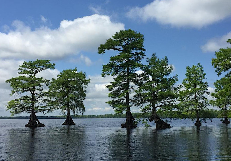
the bald cypress is now the iconic tree seen in the Great Dismal Swamp at the edge of Lake Drummond
Source: US Geological Survey (USGS), Great Dismal Swamp, Lake Drummond
Forest regeneration was altered where land was timbered, then ditched and drained for planting crops. The Washington Ditch, completed before the start of the American Revolution, stretched from the Suffolk Scarp east to Lake Drummond. The next major drainage effort was construction of the Jericho Ditch in 1810, linking Suffolk with the lake.
The Dismal Swamp Canal was built in 1793-1805, with the Feeder Ditch connecting Lake Drummond to it in 1812. The canal banks interrupted the surface sheet flow of water eastward into the "Green Sea," a vast expanse of river cane (Arundinaria gigantea) that grew 15' high. Ditches allowed faster and deeper drainage, which facilitated the drying out of land and establishment of farms east of the canal. As a result, the Great Dismal Swamp is roughly 50% of its original extent. Lake Drummond, originally about 15' deep, is now 6' deep.
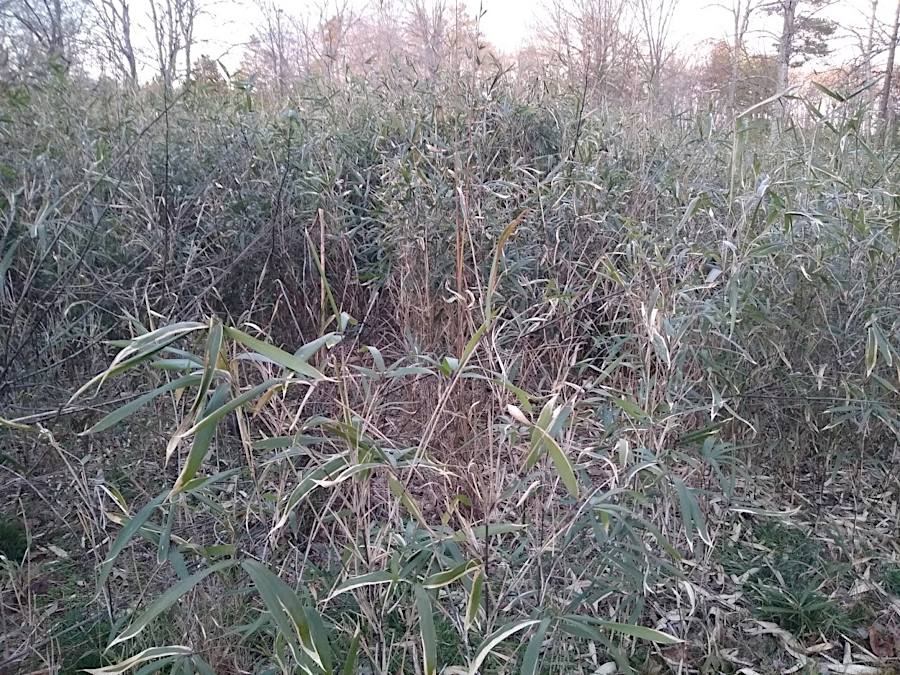
the Green Sea east of the Dismal Swamp was covered in river cane (Arundinaria gigantea), a bamboo native to Virginia
For loblolly pine (Pinus taeda), lower water from the ditches affected growth patterns:5
Efforts to drain swamps altered the hydrologic regime, triggering the growth of hardwoods and blocking reproduction of Atlantic White Cedar. By one description, the cedar forest were "mined" rather than "managed."6

forest with Atlantic White Cedar at Dismal Swamp
Source: US Fish and Wildlife Service National Digital Library
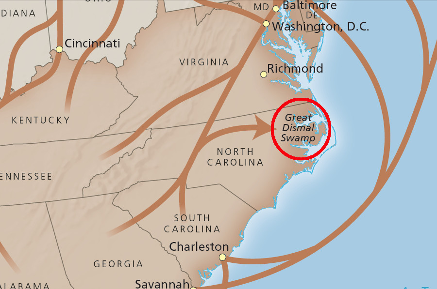
In 1763, George Washington and 11 other land speculators organized the Adventurers for Draining the Dismal Swamp and made the first major effort to drain and develop the wetland. Ditches were dug towards the north to drain to the Chesapeake Bay, diverting the natural flow of the Dismal Swamp towards the Atlantic Ocean and Albemarle Sound. The Okefenokee Swamp in Georgia is also near a watershed divide. The Okefenokee Swamp is the source of the St. Marys River flowing east to the Atlantic Ocean and the Suwannee River flowing south to the Gulf of Mexico.
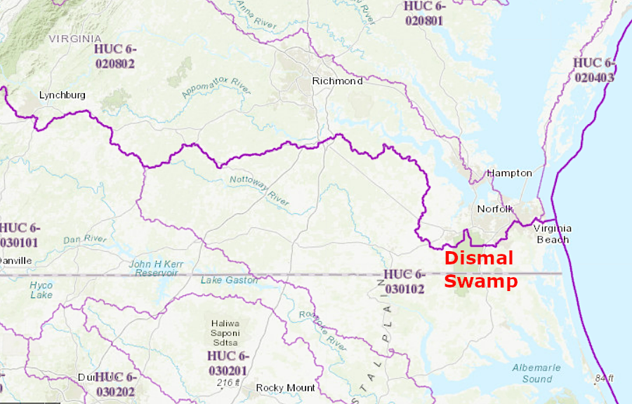
the Dismal Swamp did not drain naturally toward the Chesapeake Bay, but ditches crossed the very low watershed divide (purple line)
Source: US Geological Survey (USGS), The National Map
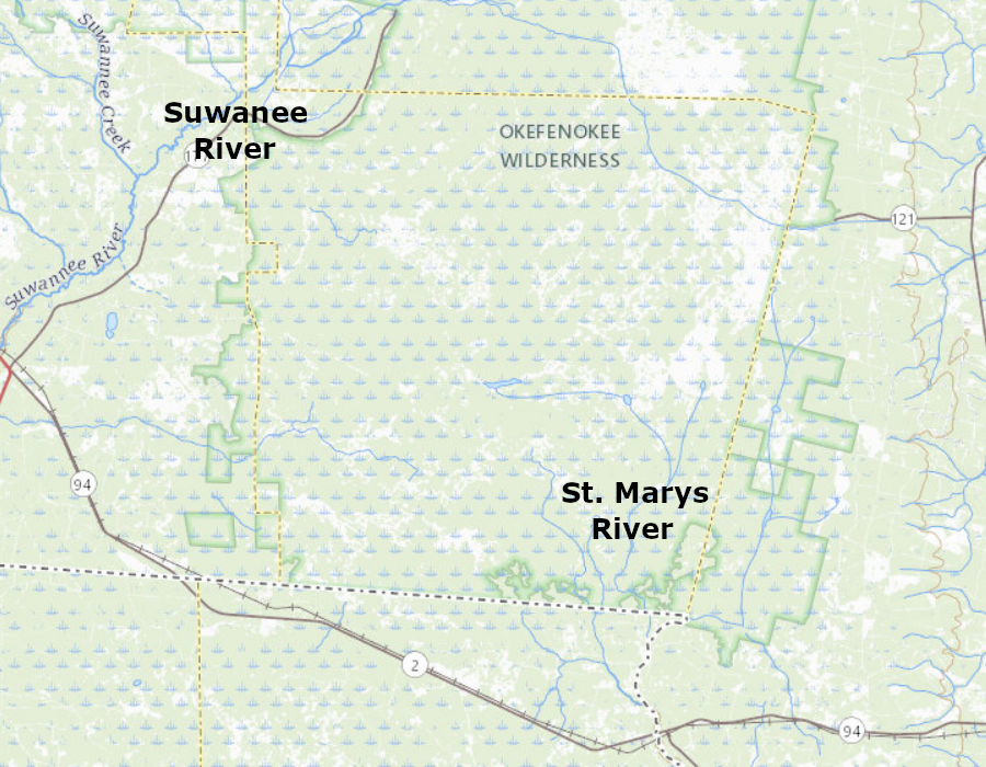
the Okefenokee Swamp is on the watershed divide, with the St. Marys River flowing east to the Atlantic Ocean and the Suwannee River flowing south to the Gulf of Mexico
Source: ESRI, ArcGIS Online
Profits were projected from the sale of timber products, especially shingles split from the bald cypress trees (Taxodium distichum). Later profits would come from farming the land after it was drained to grow food crops and hemp for fiber.
Washington went to the swamp six times before the American Revolution to oversee the effort. Ditches intended to remove the water were excavated by 60 enslaved men, and those ditches also provided a way to float timber products to market at Suffolk. The first ditch excavated is still known as Washington Ditch. Washington used shingles made from Atlantic White Cedar (Chamaecyparis thyoides) trees to cover Mount Vernon.7
multiple ditches drain Lake Drummond and Great Dismal Swamp
Source: US Geological Survey (USGS), The National Map - Hydrography
In 1785, after the American Revolution, Washington and others planned to import 300 Dutch laborers and invest more capital in the draining of the swamp. The Dismal Swamp Company's economic opportunity increased when construction of the Dismal Swamp Canal started in 1793.
At that time, Washington was serving as the first President of the United States in Philadelphia. He chose to sell his shares in the Dismal Swamp Company to "Light Horse Harry" Lee, and ceased his direct personal involvement with the efforts to convert swampland into farmland.
early English colonists avoided claiming land in the Dismal Swamp, which offered little agricultural potential
Source: Library of Congress, The lower parish of Nansemond County, Va. with adjoining portions of Norfolk County : Elizabeth City Shire 1634, New Norfolk County 1636, Upper Norfolk County 1637, Nansemond County 1642
Timber operations became profitable about the time that George Washington's estate reacquired the shares in 1809, since "Light Horse Harry" Lee failed to pay. The investors shifted strategy and abandoned the capital-intensive efforts to ditch the Dismal Swamp and create dry farmland.
Lake Drummond and Dismal Swamp Canal in 1859
Source: Library of Congress, A map of the state of Virginia (by Lewis Von Buchholtz, L. V., Herman Böÿe, Benjamin Tanner, 1859)
Over 200 years later, other entrepreneurs would succeed in draining the Everglades and convert some of that massive wetland into farmland. That process required building dikes around Lake Okeechobee and redirecting flow into artificial ditches. The resulting sugar plantations were far more profitable than the effort to convert the Dismal Swamp into farmland.
Jericho Ditch, Great Dismal Swamp National Wildlife Refuge
Source: US Fish and Wildlife Service, National Digital Library
The Dismal Swamp Company was rechartered as the Dismal Swamp Land Company, and it focused on cutting and processing the trees. Private owners stripped the forest for the next 150 years.8
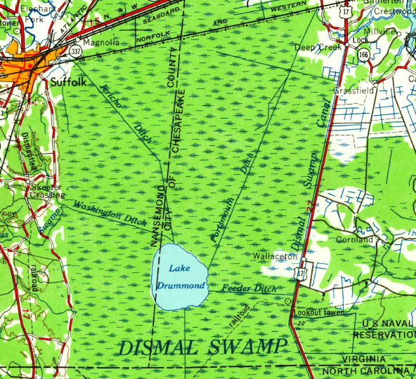
in 1953, the new City of Chesapeake had replaced Norfolk County on the eastern edge of Lake Drummond, but the City of Suffolk had not yet replaced Nansemond County on the west
Source: US Geological Survey (USGS), Lake Drummond 7.5x7.5 topographic map (1953)
Camp Manufacturing Company purchased the land of the Dismal Swamp Land Company in 1909. A portion of the swamp was prepared for a new military airfield in World War II, but after clearing the land the runways were never paved.9
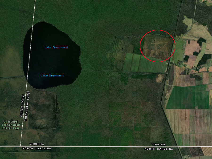
the shadow of a planned-but-uncompleted World War II military airfield is still evident
Source: ESRI, ArcGIS Online
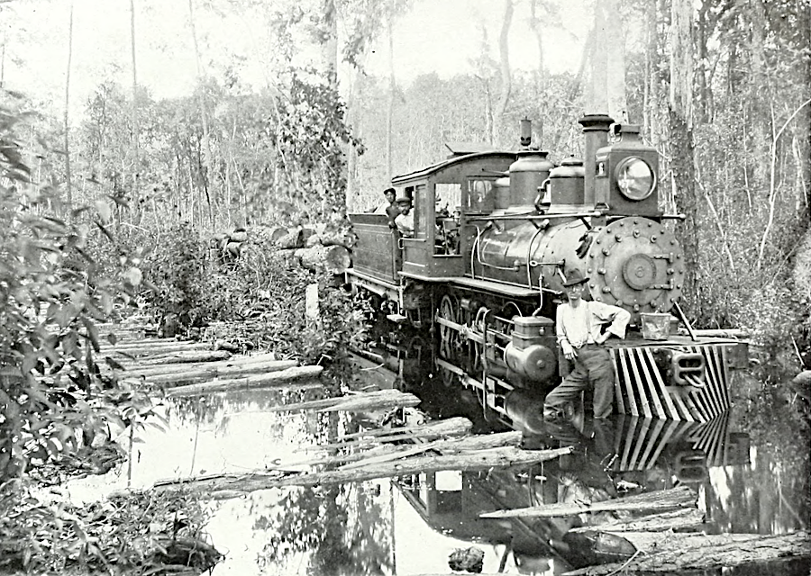
temporary rail lines were built through swamps to remove timber
Source: Surry Parker, Steam logging machinery (p.5)
By the 1950's, the Great Dismal Swamp was one of the last remaining areas with a substantial Atlantic White Cedar forest. It was at least second-growth forest, after the last 20,000 acres of virgin timber were cut in the decade after World War II. Most of the ditches and roads that affected the swamp's hydrology were constructed after World War II.
the last surge of timber removal after World War II included extensive ditch and road construction
Source: US Fish and Wildlife Service, Water Management at Great Dismal Swamp (by Frederic C. Wurster, July 27, 2017)
The Union Camp Corporation, successor to the Camp Manufacturing Company, donated 49,000 acres of logged-over swampland to The Nature Conservancy in 1973. The non-government organization transferred the property to the Federal government in 1974. The Nature Conservancy sold an additional 14,000 acres south of the Virginia border to North Carolina. That state managed its swampland property originally as a State Natural Area, and then opened Dismal Swamp State Park in 2008.
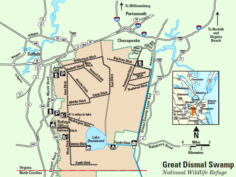
Dismal Swamp National Wildlife Refuge
Source: US Fish and Wildlife Service, Great Dismal Swamp National Wildlife Comprehensive Conservation Plan
Today, Lake Drummond is in the middle of the Dismal Swamp National Wildlife Refuge, managed by the US Fish and Wildlife Service in the Department of the Interior. Further land acquisition has expanded the refuge's property in Virginia and North Carolina to over 110,000 acres. That is only 10% of the size of the original 1.3 million acres of swamp that existed before European colonization.
In 2021, Ducks Unlimited announced an $8 million initiative to purchase 1,300 acres on the eastern edge of the swamp and establish a conservation corridor connecting it to the Cavalier Wildlife Management Area. The property was used as farmland, but Ducks Unlimited planned to restore 900 acres of historic wetlands.
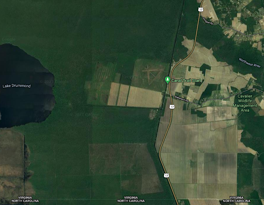
Ducks Unlimited planned to acquire 1,300 acres to link Dismal Swamp National Wildlife Refuge with Cavalier Wildlife Management Area
Source: GoogleMaps
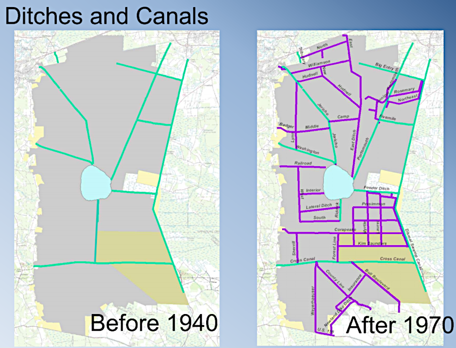
Creating the refuge defined a new priority for managing water levels at Lake Drummond. After World War II, the Union Camp Company deepened and widened Washington Ditch and Jericho Ditch, and constructed Lynn Ditch and Middle Ditch. The original versions had been too shallow to block most of the lateral flow of water eastward across the swamp, north of Lake Drummond. The spoil piles created when the ditches were dug deeper (on which roads were built) became effective barriers to water flow from Cypress and Pocosin swamps, east of Dismal Swamp.10
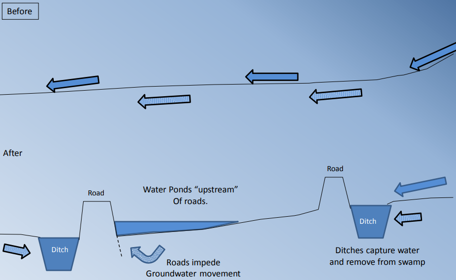
ditch and road construction blocked natural water flow in the swamp
Source: US Fish and Wildlife Service, Water Management at Great Dismal Swamp (by Frederic C. Wurster, July 27, 2017)
The Corps of Engineers must cooperate with the US Fish and Wildlife Service before releasing water into the Feeder Ditch to support navigation in the Dismal Swamp Canal. During drought periods, the top priority now is conservation of natural resources rather than pleasure boat navigation.11
One goal of the US Fish and Wildlife Service is to re-plumb the swamp in order to restore the natural flow of water. The Federal agency and Dismal Swamp State Park in North Carolina manage numerous water-control structures. The US Army Corps of Engineers controls water levels in Lake Drummond, the Feeder Ditch, and the Dismal Swamp Canal. The water control structures are managed to keep the Dismal Swamp Canal navigable, minimize flooding in the area north and east of the swamp, and mitigate the effects of the historic ditches and logging roads that have created drier-than-natural and wetter-than-natural areas.
The organic soils in the swamp are normally 85-95% water. When those soils dry out, the soil particles alter into a granular form that will not absorb water even after water levels rise again. The soil then oxidizes away, adding carbon to the atmosphere. Keeping the soils saturated is essential for minimizing the intensity and size of wildfires in the Great Dismal Swamp.12
wildfires in the swamp are fueled by accumulated peat, when conditions are sufficiently dry
Source: US Geological Survey (USGS), Hydrologic Conditions and Simulation of Groundwater and Surface Water in the Great Dismal Swamp of Virginia and North Carolina (p.6)
Hurricanes and major forest fires, influenced by the altered drainage, alter the ecosystem even more rapidly. In 2003, Hurricane Isabel flattened 80% of the purest cedar stands in the refuge, after soil dried out and roots were unable to withstand the wind pressure. Fires - and prevention of fires - threaten the continued existence of the Atlantic white cedar plant community:13
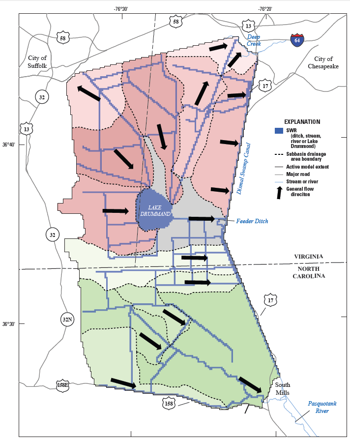
water flows north from the Dismal Swamp towards Suffolk and Deep Creek, as well as east and southeast
Source: US Geological Survey (USGS), Hydrologic Conditions and Simulation of Groundwater and Surface Water in the Great Dismal Swamp of Virginia and North Carolina (Figure 27)
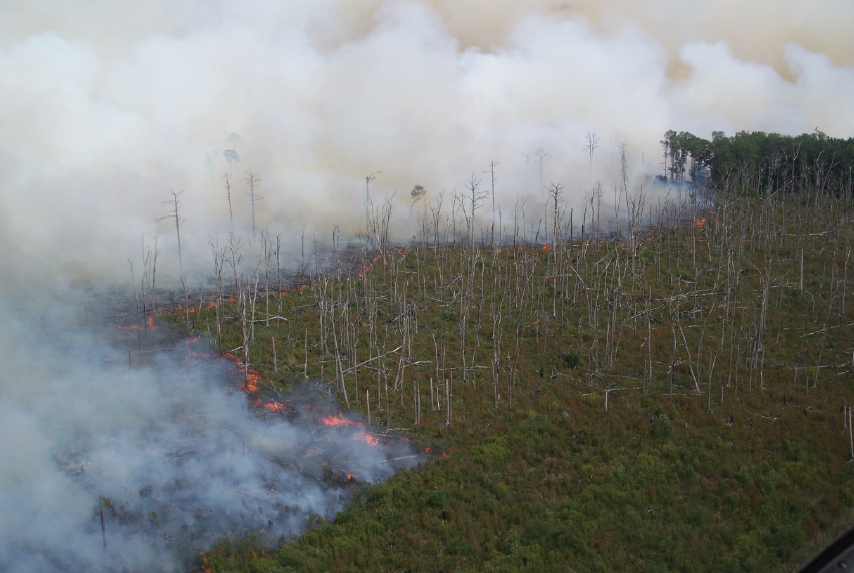
Fire is natural in Dismal Swamp, but the change in drainage and historical timber harvesting has increased the frequency and intensity of fires. After the peat has burned, tree stumps were exposed "perched on their roots, high above the burned surface. They became dry sites allowing pine seeds to sprout, leading to forest regeneration but with a different pattern of tree species.14
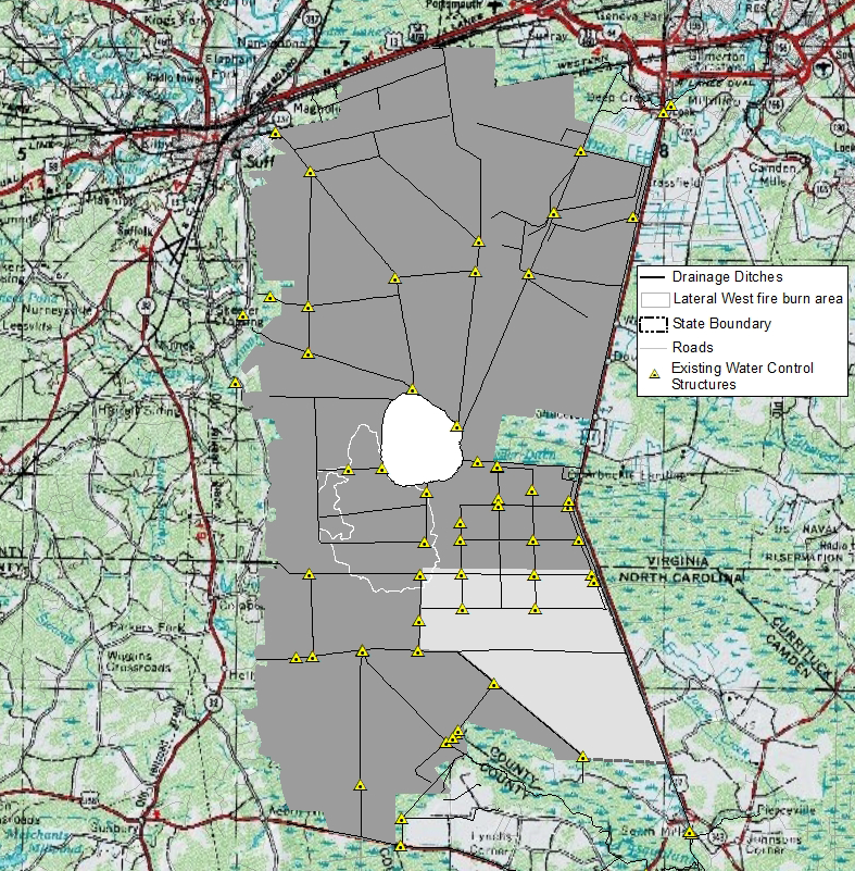
The 100 miles of ditches within the Great Dismal Swamp have resulted in a lower water table, draining away rainfall before it can seep into the peat. The moist soil, essential to growth of the Atlantic White Cedar, has dried out. In 2011, a fire started in early August and burned for 110 days. The Lateral West fire consumed accumulated peat as well as timer and brush on the surface, and ultimately lowered the peat level in the burned area by 1.5 feet. The 12" of rain that fell during Hurricane Irene in late August drained out of the swamp so quickly that the wildfire was not drowned by the massive amount of rain.15
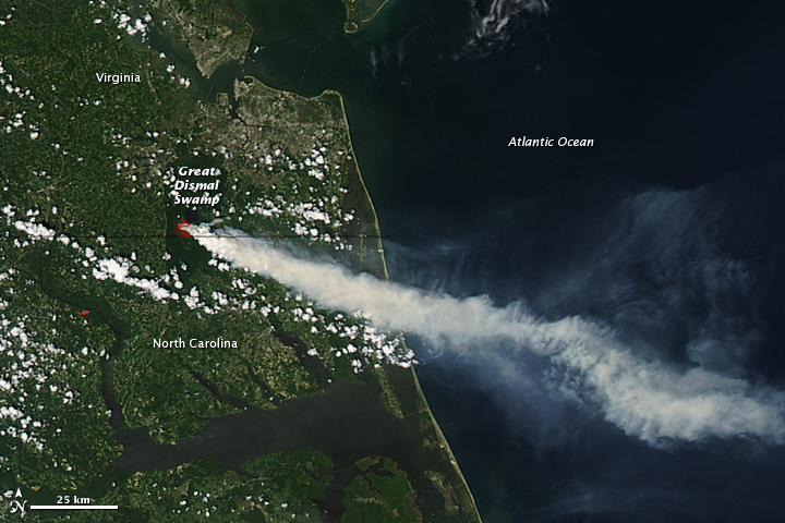
Dismal Swamp Lateral West fire from space, August 2011
Source: National Aeronautics and Space Administration (NASA), Earth Observatory, Fire in Great Dismal Swamp, Virginia
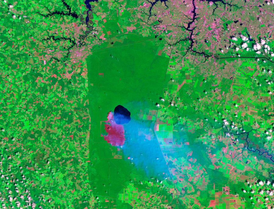
imagery from the Landsat 5 satellite shows the area southwest of the lake already burned by the Lateral West fire by August 15, 2011
Source: National Aeronautics and Space Administration (NASA), Earth Observatory, Hurricane Irene Dampens Great Dismal Swamp Fire
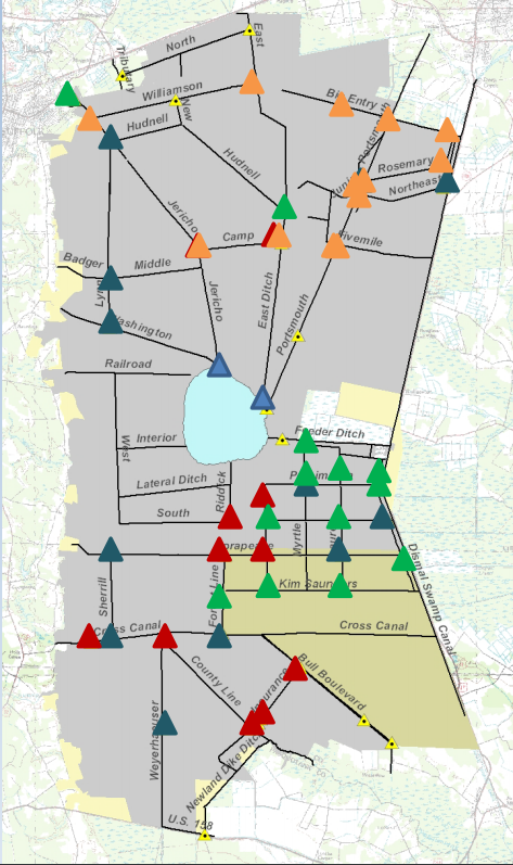
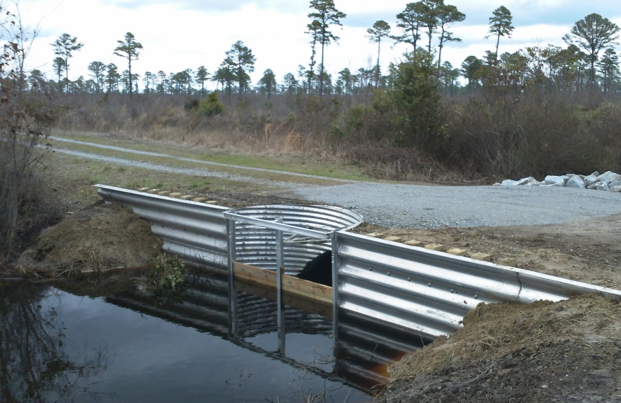
In 2013, Federal land managers installed new weirs to raise water levels in the ditches, hoping to re-saturate the peat and restore the natural ecosystem over time. The US Fish and Wildlife Service proclaimed that re-watering 9,500 acres, by controlling flow in South Martha Washington Ditch and Kim Saunders Ditch, was the largest restoration project for forested wetlands east of the Mississippi River.
Historically, the swamp was a carbon sink. Plants extracted carbon dioxide (CO2) from the atmosphere through photosynthesis, making complex carbohydrates for cell walls and other organic molecules. High water levels prevented the dead plant material from decomposing completely, and the Great Dismal Swamp sequestered more carbon than it released. Between 1985-2015, however, six major fires burned accumulated peat and the swamp added carbon source to the atmosphere.
Keeping the peat wet was predicted to trap an amount of carbon equal to what 16 million cars emit annually. Additional water control structures added in 2017 increased the ability to manage water levels in the northern 30,000 acres of the refuge. In addition to encouraging regrowth of the Atlantic white cedar, the enhanced water management would allow Federal officials to retain water to reduce fire risk and to extinguish fires that do start.
The Fish and Wildlife Service refuge manager noted:16
water control structures in the Dismal Swamp National Wildlife Refuge allow control of water levels - except in droughts
Source: US Fish and Wildlife Service, Water Management at Great Dismal Swamp (by Frederic C. Wurster, July 27, 2017)
Water levels of the lake and swamp are controlled by Federal land managers. The national wildlife refuge is intensely managed, and not one of the 24 areas designated as "wilderness" in Virginia. Of the 63 water control structures in the refuge, 57 have been repaired, replaced, or installed since the refuge was established in 1974.
The US Fish and Wildlife Service planned to use the water control structures to raise water levels slowly. If the peat soils were re-saturated too quickly, the hardwood species would be drowned before new cypress and cedar trees developed.
The US Geological Survey completed a computer model in 2018, allowing refuge managers to calculate how to block and/or redirect water in the various ditches to achieve desired water levels. Stopping drainage via one channel pushes the water towards another channel. The computer model included the 150 miles of ditches and numerous barriers created by elevated roads. The roads served as dams, causing the swamp to be unnaturally wet on one side and unnaturally dry on the other.
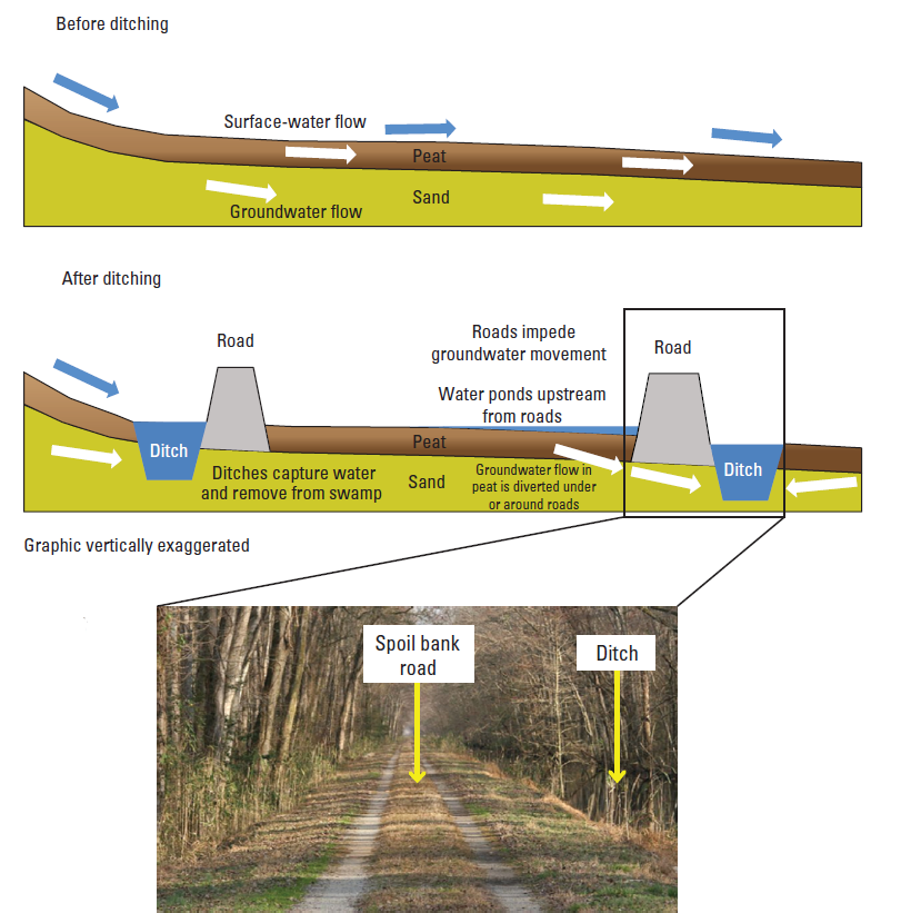
roads, built on the dirt ("spoil") piled up after excavating a ditch, act like dams in the Dismal Swamp
Source: US Geological Survey (USGS), Hydrologic Conditions and Simulation of Groundwater and Surface Water in the Great Dismal Swamp of Virginia and North Carolina (Figure 11)
Research revealed that 92% of the refuge's water arrived via rain. Only 5% came from streams flowing off the Suffolk Scarp, and 3% reached the surface from groundwater seeps. Offsetting the inputs were the outputs, the loss of water from the swamp. 55% evaporated, 41% drained out via ditches, and 4% re-entered the groundwater aquifers.
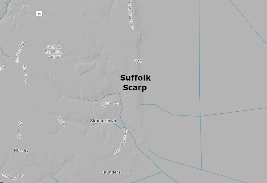
few streams cross the Suffolk Scarp and drain into the Dismal Swamp
Source: ESRI, ArcGIS Online
The initial focus was to manage the water flowing into Portsmouth Ditch, in the northeastern corner of the swamp. It carried excessive amounts of water out of the refuge, constraining the regeneration of cypress and cedar forests while occasionally flooding the Deep Creek area.17
water control structures in the Dismal Swamp National Wildlife Refuge allow control of water levels - except in droughts
Source: US Fish and Wildlife Service, Water Management at Great Dismal Swamp (by Frederic C. Wurster, July 27, 2017)
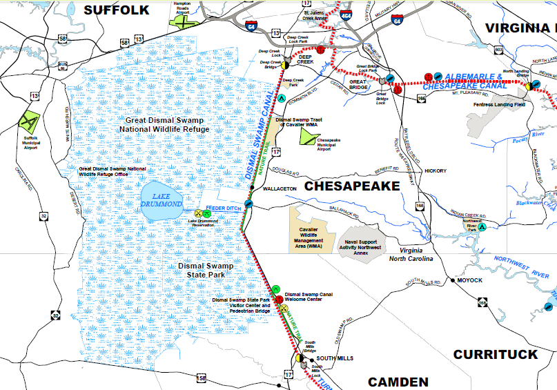
During dry periods, the Corps of Engineers opens gates at the western end of the Feeder Ditch to release water into Dismal Swamp Canal in order to maintain the 6' deep shipping channel (Route #2 on the Atlantic Intracoastal Waterway, Marine Highway M-95). Water is also released when lake levels rise too high.
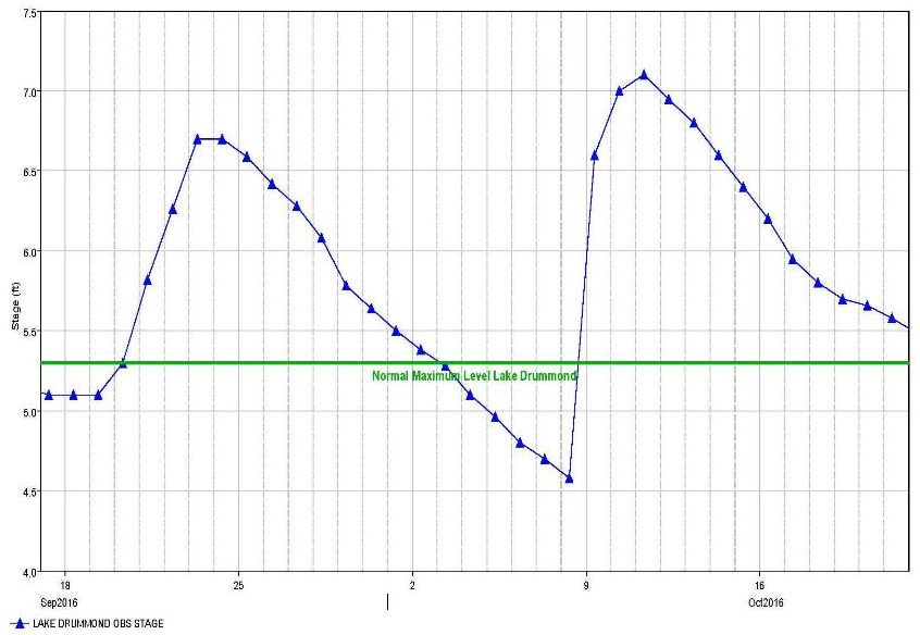
In 2016, over 30 inches of rain fell on Hampton Roads in September/October in three storms, Hermine, Julia and Matthew. The 11 inches of rain from Tropical Storm Julia at Lake Drummond were a surprise; only 4 inches had been predicted. The Corps opened all spillway gates on the Dismal Swamp Canal to reduce the water level in the shipping channel, then opened the Lake Drummond spillway gates.
Dismal Swamp Canal, a Corps of Engineers project
Source: US Army Corps of Engineers, Atlantic Intracoastal Waterway General Information
The gates stayed open for 11 days, reducing the lake level by 9 inches before the arrival of Hurricane Mathew. That storm dropped another 11-12 inches of rain, creating highest water levels ever recorded on the canal. It took over a year for the Corps to dredge the sand and remove the trees blocking the canal before it reopened.
However, the shift between fire and flooding risk is swift. The next few months were dry, and the refuge manager began to worry just four months later that the swamp would be on fire again by the early summer.18
Corps of Engineers water management after Tropical Storm Julia and Hurricane Mathew mitigated flooding at Lake Drummond
Source: US Army Corps of Engineers, Atlantic Intracoastal Waterway (July 27, 2017)
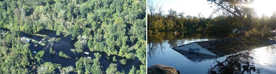
despite Corps of Engineers water management efforts, Hurricane Mathew flooding the spillway and boathouse at Lake Drummond
Source: US Army Corps of Engineers, Atlantic Intracoastal Waterway (July 27, 2017)
Hunting deer and the 300 bears in the wildlife refuge is authorized. The "natural" character of the refuge has been modified heavily by ditching and timber harvesting. There are few structures, but the landscape is controlled by Fish and Wildlife Service and Corps of Engineers intervention to keep the swamp wet.
A wet Dismal Swamp provides excellent habitat for breeding mosquitoes in the summer; visitors to the 113,000-acre wildlife refuge get to experience annoying as well as attractive critters. The mosquitoes are considered wildlife, like bears and birds. Because the Great Dismal Swamp National Wildlife Refuge is Federally-protected, the City of Suffolk is not allowed to spray chemicals within the refuge to kill the mosquitoes.19
The effect of that prohibition extends beyond the refuge boundaries. Mosquitoes are the primary vector that transfers Eastern equine encephalitis (EEE) and West Nile virus from birds in the refuge to horses and humans in the cities of Suffolk and Chesapeake. There is a tradeoff between protecting natural processes in natural areas vs. protecting human health. People and horses in South Hampton Roads have a higher risk of exposure to some diseases, because the habitat and animal populations (including mosquitoes) within Great Dismal Swamp National Wildlife Refuge are protected.
When the US Fish and Wildlife completed the Comprehensive Conservation Plan in 2006 for managing the Great Dismal Swamp National Wildlife Refuge, it considered designating six areas as "wilderness." The areas were roadless, but were altered by water management structures and activities required to maintain the habitat and reduce fire risk.. The wilderness review re-affirmed a 1974 decision that human activities had altered the pristine character of the swamp too much for the area to qualify under the Wilderness Act of 1964 as:20
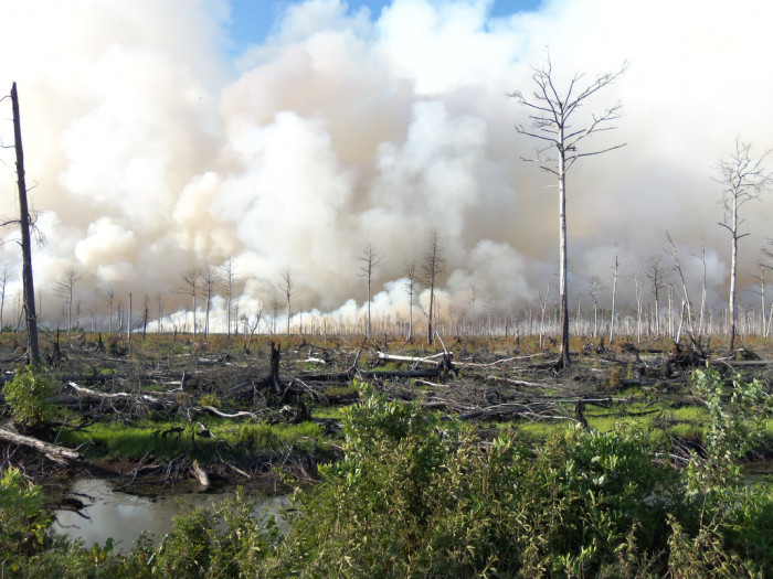
Lateral West Forest Fire burns towards Corapeake Ditch at Great Dismal Swamp National Wildlife Refuge, 2011
Source: US Fish and Wildlife Service, National Digital Library
the Dismal Swamp National Wildlife Refuge is not managed as wilderness; there are over 60 water control structures
Source: US Fish and Wildlife Service, Water Management at Great Dismal Swamp (by Frederic C. Wurster, July 27, 2017)
Though wilderness designation is unlikely for any part of the refuge, it was designated as a National Heritage Area by the US Congress in 2022 due to the unique history and cultural landscape.21
The swamp has been a refuge for people as well as wildlife. As colonists expanded their control over the region in the 1600's and 1700's, members of the Nansemond, Haliwa-Saponi, and Meherrin tribes managed to maintain their lifestyle within the swampland.
They were joined there by people who fled from slavery, creating colonies of "maroons" who occupied islands within the swamp. Archeology completed after 2003 suggests they planted grains such as corn on dry island land, and the Great Dismal Swamp became the largest community of maroons in North America. The residents finally dispersed after the Civil War brought an end to legal slavery.
The author of Dismal Freedom: A History of the Maroons of the Great Dismal Swamp has described how whites in the area tolerated maroon settlements on the edge of the swamp, because they created opportunities to trade for low-cost shingles produced by those settlements. Other settlements were isolated deeper in the swamp; some residents may have lived their entire lives without ever leaving the swamp, and perhaps without ever seeing white people.
Nat Turner led an uprising of enslaved men and women in Southampton County in August, 1831. He planned to march to the Dismal Swamp after capturing the armory at Jerusalem (now Courtland). In response to the uprising, militia and Federal military forces planned to search the Dismal Swamp and stop the assumed 2,000-3,000 fugitives there from joining the uprising:22
The uprising was stopped within two days, though Turner escaped capture for two months. The military units avoided going into the Dismal Swamp. The expected resistance may have deterred the militia, though the logistics of getting large groups through the swamp must have also been a consideration.
The ability of maroons to survive on their own initiative in the swamp undercut claims that slavery was justified because it was the only way to provide food and shelter for a lesser class of humanity:23
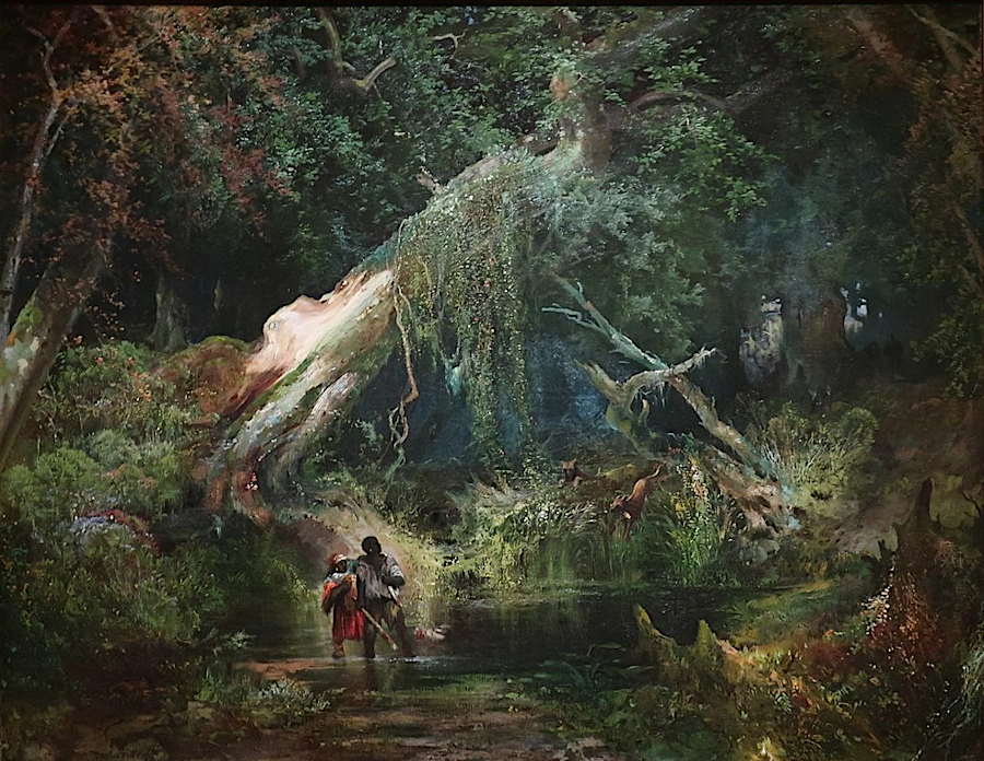
before the Civil War ended slavery, one option in southeastern Virginia was to flee into the Great Dismal Swamp
Source: Philbrook Museum of Art, Slave Hunt, Dismal Swamp, Virginia (by Thomas Moran, 1861-62)
Descendants of those who worked and lived in the swamp organized the Great Dismal Swamp Stakeholders Collaborative. Based in part on their lobbying, President Biden signed the Great Dismal Swamp National Heritage Area Act on January 6, 2023. It directed the Department of the Interior to study if the site should be designated as the Great Dismal Swamp National Heritage Area. That would increase the potential for Federal funding to highlight the history of the people who used it as a refuge.
When asked why he was lobbying, one descendant said:24
Ditching and draining of the swamp since European colonists arrived has transformed it from a caron "sink" into a carbon "source." As peat has dried out and oxidize, or has burned, methane, carbon dioxide, and other gases have been released from the swamp over the recent centuries. The efforts of the US Fish and Wildlife Service to elevate the water table and "re-wet" the swamp by blocking drainage channels is not having enough impact; carbon losses are still exceeding carbon sequestration.
Vegetation regrowing in disturbed areas is less diverse than in the natural swamp. Red maple trees are an effective colonizer, growing quickly in spaces cleared after storms and fires as well as human disturbance. The "homogenized" habitat offers fewer niches for wildlife, reducing the diversity of life in the area.
A research geologist for the US Geological Survey said in 2024:25
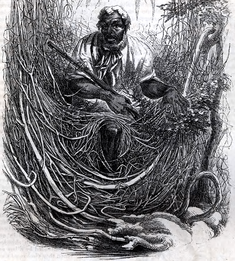
people who escaped slavery successfully avoided capture by living in the Great Dismal Swamp
Source: Library Company of Philadelphia, Osman (by David Hunter Strother, from Harper's New Monthly Magazine, September 1856)
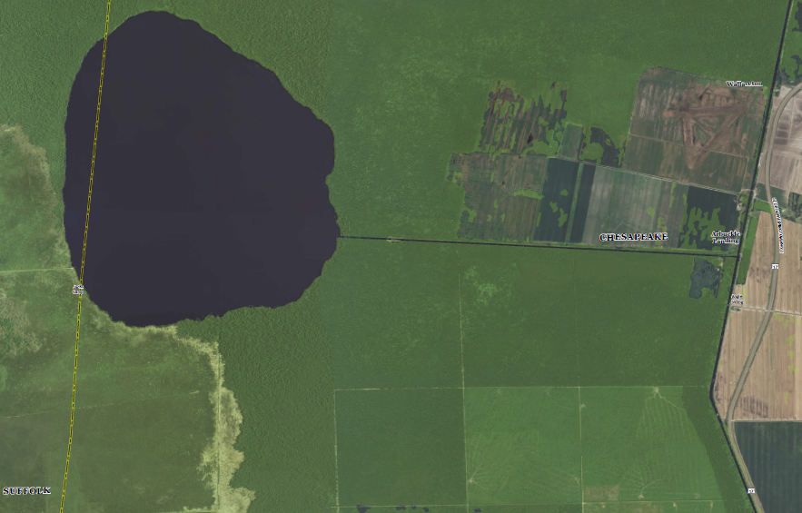
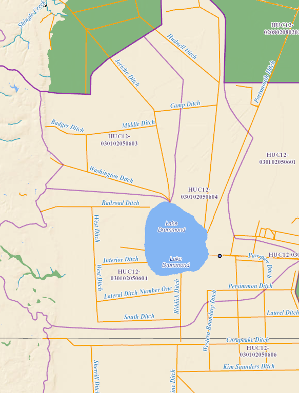
a portion of Lake Drummond is located in the City of Suffolk, but all of the Feeder Ditch leading to the Dismal Swamp Canal at Arbuckle Landing is within the City of Chesapeake
Source: US Geological Survey (USGS), Lake Drummond USGS Topo Revision 1 (2013)
Dismal Swamp National Wildlife Refuge
Source: US Fish and Wildlife Service, Great Dismal
Swamp National Wildlife Refuge brochure
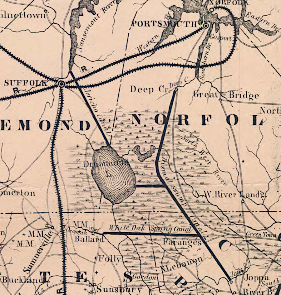
shingles were shipped via the Jericho Ditch to Suffolk
Source: University of North Carolina, Railroad map of North Carolina (c.1861)
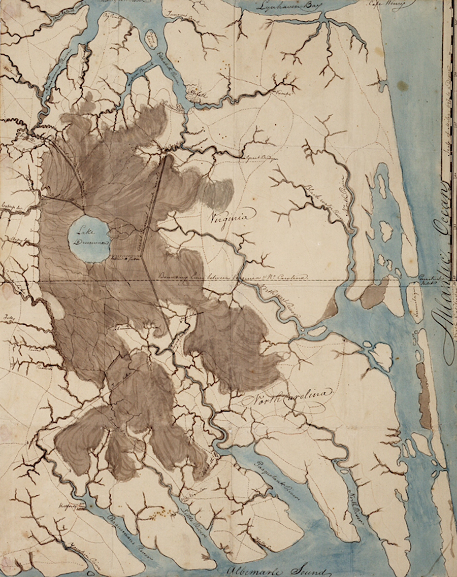
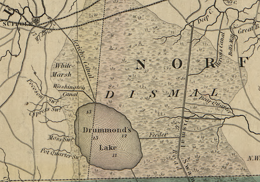
the swamplands around Lake Drummond (dark brown) were far more extensive in 1808 compared to today
Source: Royal Museums Greenwich, Sketch map of the Great Dismal Swamp (1808)