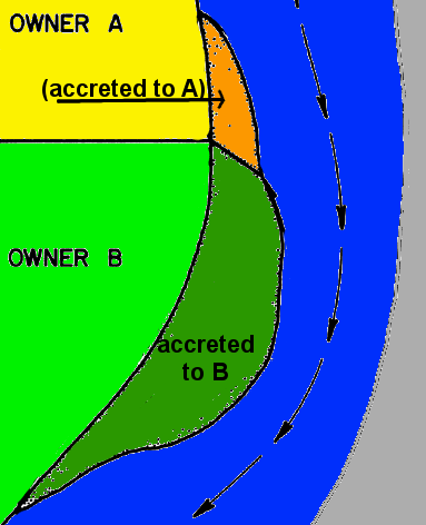
riparian landowners normally acquire ownership of accreted lands, based on river frontage
Source: Bureau of Land Management, Public Lands Surveying Casebook, Basic Law of Water Boundaries (D1-2)
riparian landowners normally acquire ownership of accreted lands, based on river frontage
Source: Bureau of Land Management, Public Lands Surveying Casebook, Basic Law of Water Boundaries (D1-2)
Submerged lands can grow through natural processes, with sediments being deposited gradually by stream currents or quickly in a storm. Owners of shoreline property can see their parcels enlarge slowly by the process of accretion, or rapidly by the process of avulsion, as once-submerged land is exposed to the surface.
The mechanics of how a parcel grows can determine the ownership of the new land. Is a parcel expands through slow accretion, the adjacent property owner acquires property rights to the newly-created surface. For example, a gravel bar on the inside of a river bend may increase in acreage, as a river deposits sand and plants ultimately grow on the new land. The riparian landowner, who owned the gravel bar adjacent to the river, ends up owning a larger gravel bar.
The doctrine of accretion, granting ownership of a shifting sandbar to the riparian landowner, simplifies the process of determining who owns new land created as river currents adjust shorelines. If local tax assessors are paying attention during re-appraisals, the size of the taxable parcel is increased and riparian property owners with accreted parcels get a bigger real estate tax bill.
When a gravel bar expands on the inside of a river's bend, typically the river erodes away the land on the outside of the bend. The process of reliction literally erodes property ownership, as a river naturally reshapes the land. Smart property owners highlight such changes to tax assessors, in order to reduce their local real estate taxes. (The same process of accretion and reliction occurs on ocean/Chesapeake Bay shorelines, especially on barrier islands, as well as on river shorelines.)
If a river changes course quickly, cutting a new channel, then a landowner with property on just one side of a river suddenly may end up owning property on both sides. The rapid change of the river's location, known as avulsion, does not alter ownership boundaries. Old surveyed parcel boundaries continue to define ownership after an avulsion event, including cutting a canal through a bend in the river.
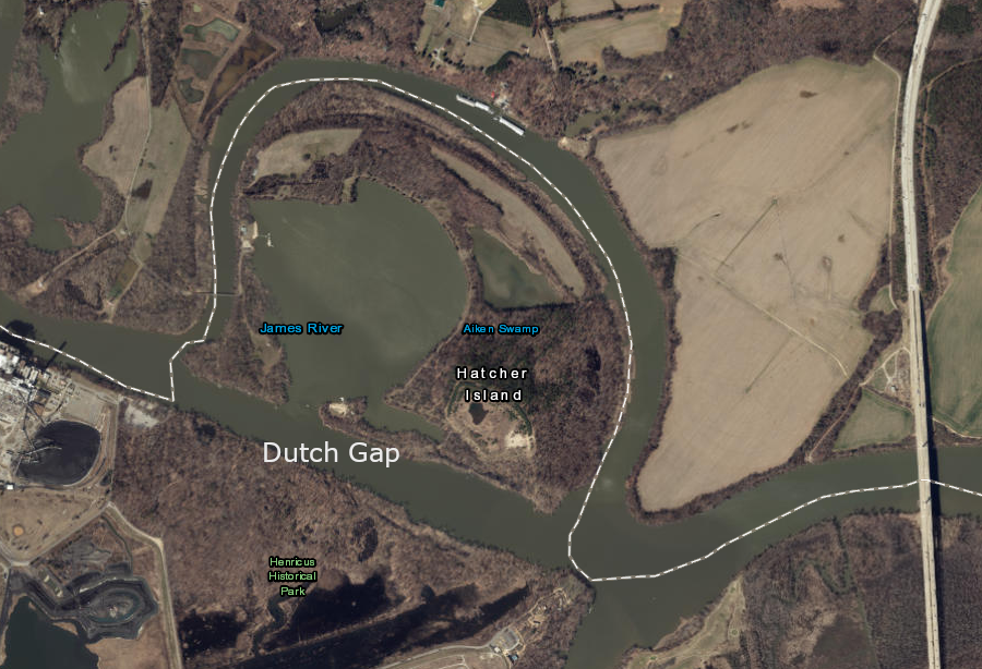
carving the Dutch Gap Canal on the James River was equivalent to avulsion, so the no river path did not change property boundaries
Source: ESRI, ArcGIS Online
Coastal shoreline landowners can acquire ownership of a new, broader beach by avulsion. Obtaining clear title today may require documenting the rapid change of land/water boundaries through surveys and historic photos and filing a new deed with the local court. The ownership of newly-created Willoughby Spit in 1697 was ensured by getting a revised land grant from the colonial government:1
Submerged lands also can become dry surface through intentional dumping of rocks and fill dirt. After the War of 1812, the state of Virginia gave the Federal government 250 acres at Point Comfort to build Fort Monroe and 15 acres at the Rip-Raps shoal off Old Point Comfort to build Fort Calhoun. Construction of Fort Monroe started in 1819, the state agreed to donate the land in 1821, and the deed transferring the land to the Federal government was finally executed in 1838.2
The Rip-Raps shoal was enlarged with heavy rocks and new land was created above sea level. Fort Calhoun was constructed on top, so the cannon of that time could control various shipping channels.
To expand Fort Monroe on Old Point Comfort, the Commonwealth of Virginia sold 31 acres of submerged lands underneath Mill Creek to the Federal Government in 1908. The sale recognized that the owners of oyster leases would have to be compensated.3
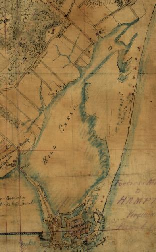
since 1861, submerged lands underneath Mill Creek to the north and portions of Hampton Roads west of the historic fort were filled in
Source: Library of Congress, The Union army encampment at Hampton, Virginia Showing picket lines and Fortress Munroe
When Fort Monroe was closed, some land conveyed by the state to the Federal government reverted back to the state, according to the original conditions for the Federal government to use the land for military purposes.
The Federal government claimed full ownership of the accreted land, land that had been below the original mean low water line in 1908. Four structures located on both sides of the 1908 mean low water (MLW) boundary line ("bifurcated buildings") were appraised based upon the percentage located on acquired-in-1908 vs. accreted-since-1908 land.4
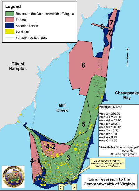
Fort Monroe, showing lands to be reverted to Virginia (in green) and accreted lands (in blue)
Source: Fort Monroe Restoration Advisory Board, Orientation Briefing (September 19, 2006)
When Fort Monroe was closed in 2011 as part of the Base Realignment and Closure (BRAC) process, the state and Federal government disagreed on ownership of accreted land at Fort Monroe. When the Federal government directed appraisers to determine the value of the land at Fort Monroe, it drew a boundary between the land to be reverted back to Virginia (based on a 1908 purchase) and the land accreted since 1908.
Even after the governor of Virginia accepted the quitclaim deed from the Army for Fort Monroe, ownership of 70 acres of accreted land (including the 332-slip Old Comfort Point Marina and The Marina Cafe built on that land) remained in dispute. Transfer required Congressional action, using the 2014 National Defense Authorization Act to declare that Virginia owned the 70 acres but the state's Fort Monroe Authority would have to split any revenue from future land sale/leases with the US Army.5
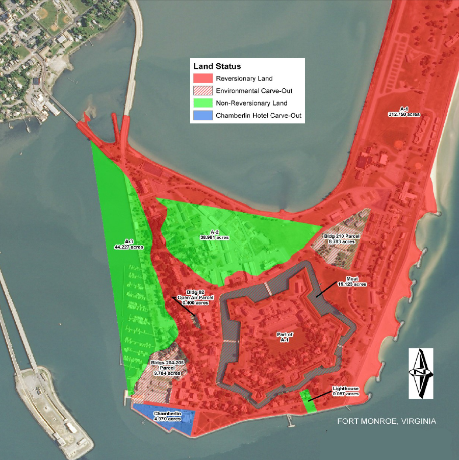
the US Army claimed ownership of the lighthouse and the other two green parcels, which had been marshland filled by the US government to become solid, buildable land
Source: US Army, Fort Monroe, VA Conveyance Progress Report (2018)
Action by Congress also clarified ownership of the submerged land used to stockpile sediments dredged from the ship channels at Norfolk, and deposited at the Craney Island Dredged Material Management Area. The state of Virginia gave 3,400 acres of submerged land and Craney Island to the Corps in the 1940's for disposal of dredged material, and in 2007 Congress approved expanding the facility towards the east, into the Elizabeth River. After building new dikes and filling the new cells, the expanded land will become a new Virginia Port Authority shipping terminal around the year 2028.
To clarify the state's ownership of the terminal site on the eastern edge of the Craney Island Dredged Material Management Area, Congress officially transferred ownership of 321 acres to Virginia in 2014.6
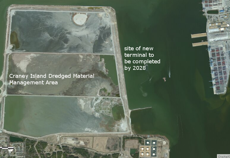
the eastern edge of Craney Island Dredged Material Management Area has been transferred back to the state of Virginia, so there is no question regarding ownership of the new shipping terminal planned to be built on land purposefully accreted at the eastern edge
Source: ESRI, ArcGIS Online
1. "Archaeological Assessment - Hampton Roads Bridge Tunnel Study," Virginia Department of Transportation, VDHR File No. 2011-0804, July 30, 2012, p.8, http://www.virginiadot.org/projects/resources/hampton_roads/HRBT_EIS/TechReports/Archaeological_Assessment.pdf (last checked December 23, 2014)
2. "The Architectural Heritage of Fort Monroe," National Park Service, 1987, pp.10-11, http://www.nps.gov/parkhistory/online_books/nnps/fort_monroe.pdf (last checked January 10, 2015)
3. "Communication From the Governor of Virginia in Reference to Conveying to the United States Government Additional Lands for the Enlargement of the Military Reservation at Fort Monroe," Journal of the Senate of the Commonwealth of Virginia, Senate Document No. 2, January 8, 1908, http://books.google.com/books?id=JKY0AQAAMAAJ&pg=PA1049#v=onepage&q&f=false (last checked January 10, 2015)
4. "Scope of Work for Appraisal Services, Fort Monroe Hampton County, Virginia Parcel A-3 (Marina Area)," Fort Monroe Parcel A-3 Appraisal Services Solicitation Package, p.2, https://www.fbo.gov/utils/view?id=fe74852e92ca52ffa55600eab1ff018b (last checked June 7, 2013)
5. "Army, Fort Monroe Authority are at odds over 70 acres," Hampton Roads Business Journal, June 14, 2013, http://insidebiz.com/news/army-fort-monroe-authority-are-odds-over-70-acres; "Governor McDonnell Signs Fort Monroe Quitclaim Deed," Commonwealth of Virginia news release, June 6, 2013, http://www.fmauthority.com/governor-mcdonnell-signs-fort-monroe-quitclaim-deed/ (last checked December 23, 2014)
6. "Vote expected on Craney Island land transfer plan," The Virginian-Pilot, May 22, 2014, http://hamptonroads.com/2014/05/vote-expected-craney-island-land-transfer-plan (last checked May 30, 2014)