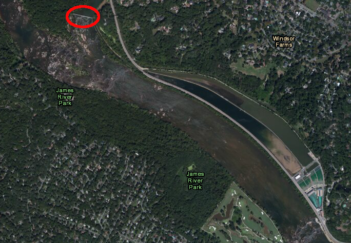
Richmond's raw water intake on the James River is at a diversion dam on the downstream end of Williams Island
Source: US Fish and Wildlife Service, Wetlands Mapper
Richmond's raw water intake on the James River is at a diversion dam on the downstream end of Williams Island
Source: US Fish and Wildlife Service, Wetlands Mapper
The Algonkian-speaking tribe that lived at the Fall Line of the James River in 1607 relied upon creeks and springs for water, as well as the constant supply of the James River. The Europeans who settled the site, which was developed into Richmond starting in 1737, also drilled community wells to provide water for drinking, cooking, and cleaning at individual houses.
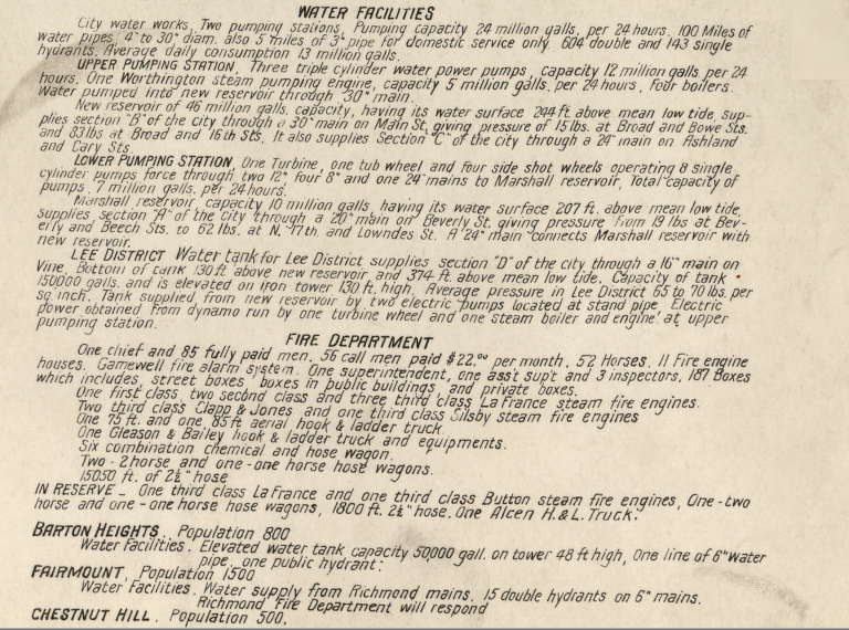
As described in 1930:1
Today, some residents still fill up jugs at springs in public parks, but Richmond relies upon the James River as its source of raw water. A dam at Williams Island diverts river water to settling basins near Byrd Park, which then supply the drinking water treatment plant.
The city's drinking water system has evolved over many years. In 1829, the General Assembly authorized the city to create a municipal water distribution system. Taxes on customers would fund the infrastructure and operations, pumping water to properties so customers would not have to walk to community wells or springs. A previous attempt by private investors in the Richmond Aqueduct Company had not resulted in any construction.
The wells within the city were growing contaminated, so in 1830 Richmond decided to draw fresh water from the James River. At the time, only 44 cities in the US distributed public drinking water; everywhere else, customers had to draw water from wells.
The city recruited a German-trained engineer named Albert Stein, who had just created a drinking water system for Lynchburg. Stein designed a standard system to pump water from the James River to the new Marshall Reservoir 160 feet above river level. From the reservoir, gravity distributed the water through pipes. The city invested $100,000 to construct the water system.
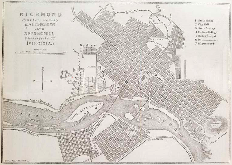
the Marshall Reservoir was west of Hollywood Cemetery and the developed area in Richmond - initially
Source: Illustrated London News, Richmond, Virginia, the Capital of the Confederate States of America (September 7, 1861); National Archives, Virginia and the Chesapeake Bay: Sheet No. 13 Richmond; Virginia Commonwealth University, Baist Atlas in Richmond, VA (1889)
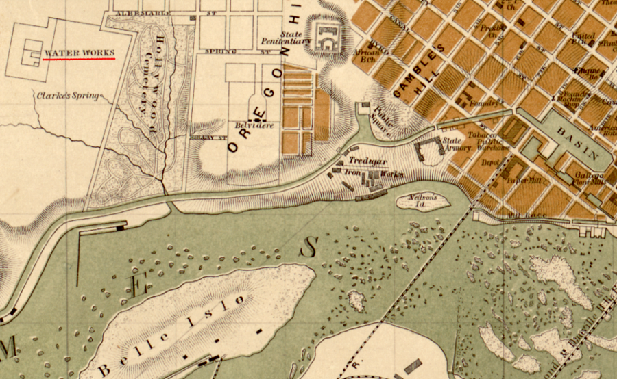
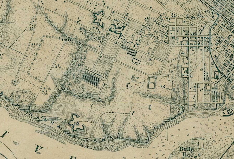
the waterworks at Clarke's Spring relied upon water pumped from the James River, then distributed by gravity
Source: Library of Congress, Map of the city of Richmond, Virginia
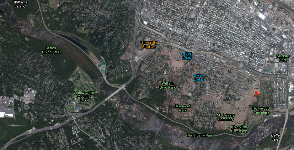
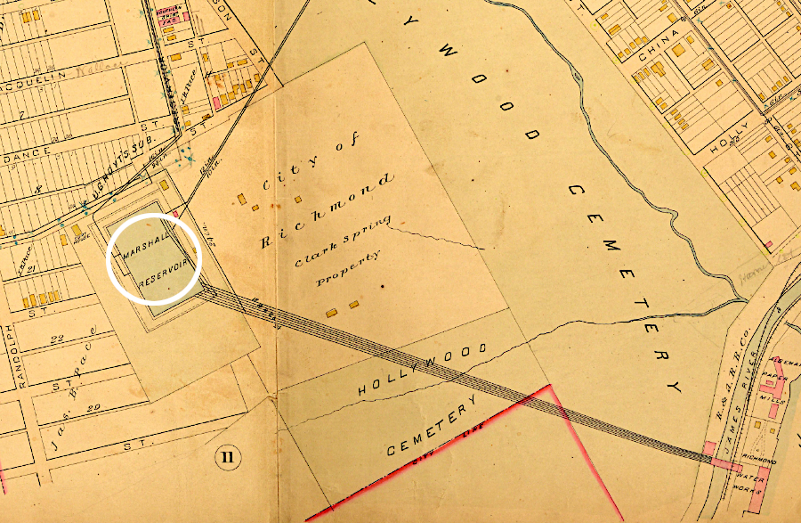
red X marks location of the old Marshall Reservoir - now Clarke Springs Elementary School
Source: US Fish and Wildlife Service, Wetlands Mapper
The unusual element was his creation of a filtration system. Richmond became the first city in the United States to build a sand filter to clean its drinking water. The project was intended to filter out the mud from the river water, improving the taste and smell of the city's water. It was not until 1854, after the London cholera epidemic, that scientists recognized clean-looking water still could harbor unhealthy bacteria and viruses.
Stein's filtration design required raw water to be pumped upwards through a bed of gravel, then through a top layer of sand. Larger particles were trapped in the gravel; smaller particles were trapped in the sand. Purging the particles from the filter required using water flowing in the other direction, draining down through the sand and gravel and flushing everything into a waste outlet.2
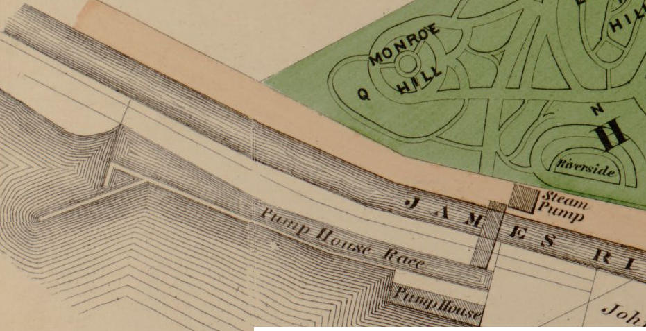
the pump to lift James River water to the Marshall Reservoir was located just upstream of the modern Lee Bridge near where President Monroe was buried in Hollywood Cemetery
Source: Library of Congress, Illustrated atlas of the city of Richmond, Va. (1877)
The filter system was abandoned after just a few years. The reservoir gained national fame after the body of a murder victim was discovered in it on March 14, 1885. The victim was pregnant, the father was her cousin, and newspaper stories about the crime entertained readers until the murderer was executed.
Marshall Reservoir was drained twice to remove mud from the bottom, once after the 1885 murder and again in 1910. The grounds around it were open to the public as a park, except during World War I. Water was finally drained from it in 1923. City officials considered using the site for a public stadium, removing the western wall and providing seats along the other three.
The Marshall Reservoir survived until 1934, when it was demolished as a public works project during the Great Depression. The dirt from the 20' high walls was hauled away and used to make Shields Lake in Byrd Park shallower for swimming, to fill gullies in Riverview Cemetery, and for landscaping Monroe Park. Today the site is the ballfield of Clarke Springs Elementary School. What was once nown as Reservoir Street is now South Harrison Street, which has been realigned so it now curves through the old reservoir site.3
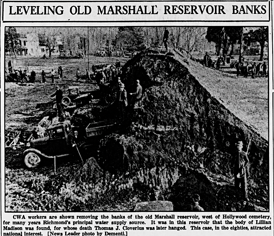
the Marshall Reservoir was abandoned in 1923 and dismantled in 1934
Source: Richmond News Leader, Baist Atlas in Richmond, VA (February 9, 1934)
In the 1870's, Richmond expanded its water system by building the "New Reservoir" a mile west of the Marshall Reservoir. The raw water intake was moved upstream, and New Reservoir Park (renamed Byrd Park in 1906) surrounded the new reservoir. The original pumping site was used to build the Hollywood Electric Plant.
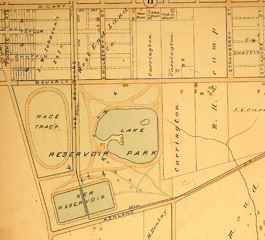
in the 1870's, the new reservoir in what became Byrd Park replaced the Marshall Reservoir
Source: Virginia Commonwealth University, Baist Atlas in Richmond, VA (1889)
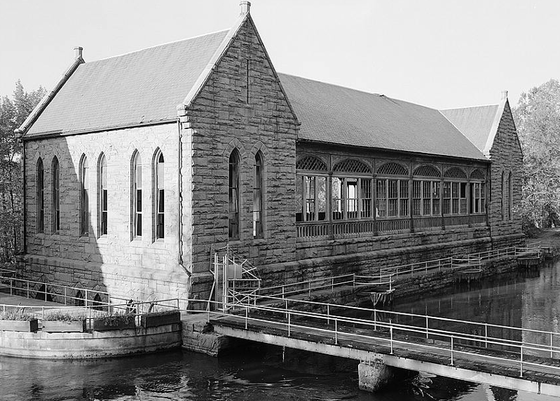
A granite Pump House was completed on the bank on the James River and Kanawha Canal in 1883, followed by two narrow settling basins. The Pump House lifted water up to the New Reservoir.
The city engineer designed the Pump House to provide a site for public gatherings, though in the segregated city some of the residents were not invited to use the space. An open-air dance hall was constructed on the second floor above the equipment room. The Pump House did double duty as an operational part of the water system and as a social hall.
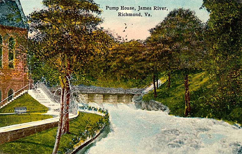
the Pump House in 1916
Source: Virginia Commonwealth University Libraries, Pump House, James River, Richmond, Va.
The city built Williams Dam in 1905, increasing the supply of water even in drought years. Chlorination started in 1913.4
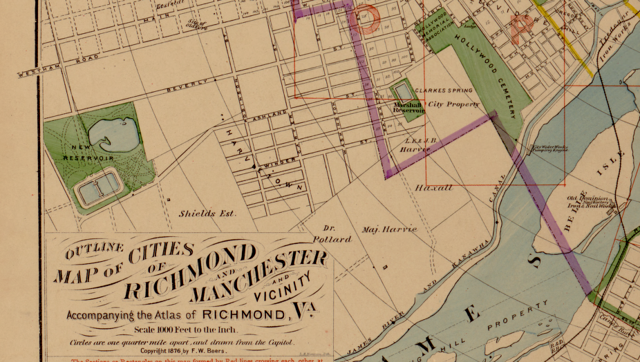
Richmond's New Reservoir was located in Byrd Park, west of the Marshall Reservoir and at a higher elevation
Source: Library of Congress, Illustrated atlas of the city of Richmond, Va. (1877)
A 1917 report indicated the settling basins had not been cleaned out since originally constructed. Silt had filled up 1/3 of the storage capacity, and the city was considering shifting the intake to draw water from behind Bosher's Dam further upstream.
At the time, the treatment process consisted of letting solids settle, using alum at times to coagulate them, then adding chlorine. The process did not produce uncontaminated drinking water. The 1917 report stated simply:5
Water was pumped from the treatment plant (at river level) to supply the west end of the city - the "high" level of elevation - from a standpipe at Byrd Park. The "intermediate" level, which included most of the city, was supplied from larger reservoirs in Byrd Park rather than the standpipe. Water flowed down from those reservoirs to the old Marshall Reservoir next to Hollywood Cemetery to supply:6
the Sanborn Insurance Company documented Richmond's water system in 1905
Source: Library of Congress, Sanborn Fire Insurance Map from Richmond, Independent Cities, Virginia (1905)
In all regions, water pressure to fire hydrants was inadequate to supply more than one engine. As the report noted:7
The functional use of the Pump House ended in 1924 when the pumps there were decommissioned. The Pump House and William Island/Williams Dam are now part of James River Park. Richmond's Department of Public Works focuses on water supply and distribution, while the recreational opportunities in the city are managed by a separate part of the city government.
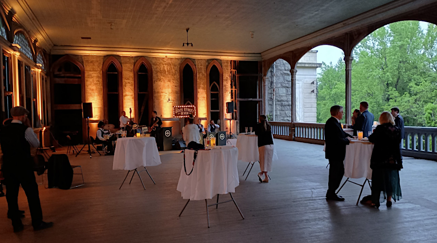
the Byrd Park Pump House was designed with a large pavilion, to provide recreational as well as utility services
Source: Library of Congress, General View Of Pumphouse From NORTH - James River & Kanawha Canal, Pumphouse
Efforts to preserve and restore the Pump House have kept it from being demolished. Friends of the Pump House now holds an annual party, Swing into Spring, at the site and arranges for tours and lectures.
City officials plan to restore the building for public use and allocated $1 million in 2026 to replace the leaking roof. New slate from quarries in Buckingham County will be used to maintain the historic character of the structure.8
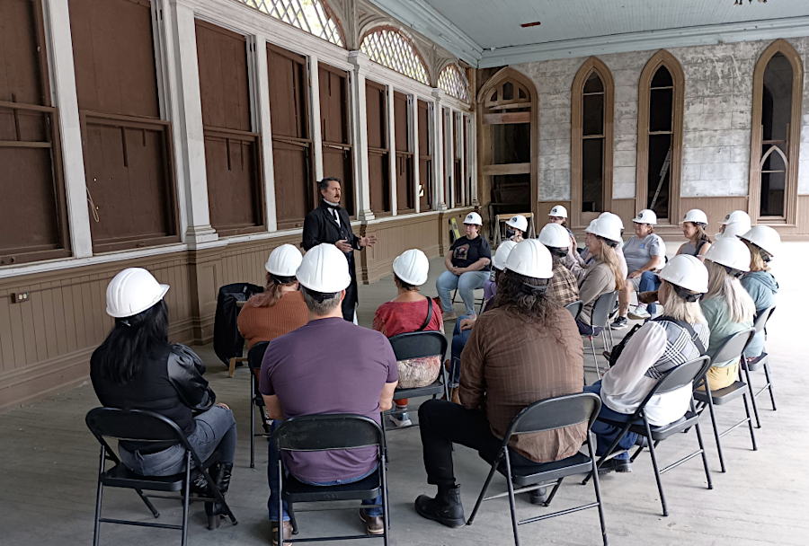
events organized by Friends of Pump House include an annual Swing into Spring party, tours and lectures
Source: Friends of Pump House, 2024 Annual Report
That assessment triggered an upgrade of the waterworks. When a new water treatment plant was completed at its current location in 1924, the city finally was able to filter its drinking water before distribution. Over time, that facility was expanded to supply 60 million gallons/day (MGD) of drinking water.
Another water treatment plant was built at the site in 1950. That second facility now can supply 70 million gallons per day. Though the rated capacity is 132 million gallons per day, in 2025 Richmond's water treatment plants typically produced 100 million gallons/day in the summer and 50-75 million gallons/day in the winter.
Source: Richmond Department of Public Utilities, Richmond, VA: Water Treatment Plant - Water Process
The City of Richmond contracted with Hanover, Henrico, and Chesterfield counties to supply them with drinking water.
The contract with Henrico County provides for the purchase of a minimum of 11.8 million gallons/day, up to a maximum of 35 million gallons/day, through the year 2040. After negotiations with Richmond, the city transferred rights to withdraw 80 million gallons/day from the James River to the county in 1994. Henrico County completed its own water treatment plant in 2004. The county will continue to purchase water from Richmond until 2040, giving the city time to amortize its investment in facilities to supply that customer.9
The intake for Henrico's new drinking water treatment plant is upstream of Boshers Dam. The county's long-term water supply will continue to be the James River, but the Virginia Department of Environmental Quality (DEQ) was concerned that increased water removal from the river during a drought would have adverse environmental impacts. Henrico's solution was to stockpile James River water in an off-stream reservoir during times of high flow, and to release that stored "extra" water during droughts.
The Cobb's Creek Reservoir was constructed in Cumberland County, with a capacity to store 14.8 billion gallons. Three earthen dams created the impoundment, and the reservoir began filling in May 2024. Henrico partnered with Cumberland and Powhatan counties to supply their needs as well. The creek's small watershed does not produce sufficient runoff to fill the planned 140-deep reservoir with 15 billion gallons of water, so Henrico will pump James River water behind the dam on Cobb's Creek at times when there is excess runoff (typically in the winter/spring).
The Virginia Department of Environmental Quality (DEQ) authorized Cumberland and Powhatan counties to withdraw an additional 47 million gallons per day of raw water per day from the river. Henrico County was assigned 30 million gallons per day, and the remaining 17 million gallons per day could be shared among the three partners.
No pipeline is planned between the Cobb's Creek Reservoir and Henrico's drinking water treatment plant. Instead, when the James River flow declines below the drinking water needs of the county (and the minimum flow levels required for fish in the river), water will be released from the reservoir upstream. That extra water will flow down the river and be withdrawn at Henrico's current intake near Bosher's Dam.10
The regional Henrico-Richmond cooperation was damaged after the Richmond water treatment plant shut down on January 6, 2025. A power outage led to flooding of critical electrical and pumping systems. Pressure in the distribution system dropped below the threshold, potentially allowing untreated water to infiltrate the pipes. The Boil Water Advisory lasted for five days, and not until January 11 did the city declare that the pipes had been flushed and disinfected adequately. All of eastern Henrico County was affected.
The Virginia Department of Health concluded after an investigation:11
Henrico County decided to spend over $300 million to build a 42" pipeline from the county's water treatment plant west of Richmond at Three Chopt and Gaskins roads to the eastern edge of the county. County supervisors were no longer willing to trust that Richmond would be a reliable partner providing drinking water. A report from the Virginia Department of Health determined that the city's water system had a backlog of "unaddressed systemic issues over decades." Richmond planned to spend $1.4 billion to upgrade its water system, but the source of that funding was unclear.
The new 13-mile pipeline, insurance in case of another supply interruption, was expected to be operational by 2031. In addition, it would provide leverage when the water supply contract between the city and county expired in 2040.12
Henrico County decided to use taxpayer funds rather than ratepayer funds to build the waterline. In many utilities, new customers pay for new waterline extensions to service their houses or commercial/industrial facilities (under a "growth pays for growth" philosophy), while ratepayers fund the maintenance of existing infrastructure.
The $300 million waterline was new, but the supervisors decided it was needed to ensure reliable delivery of water to existing rather than new customers. The result was that all taxpayers, not just the ratepayers with connections to public water and sewer, would cover the costs to establish an independent way of delivering water without relying upon Richmond.13
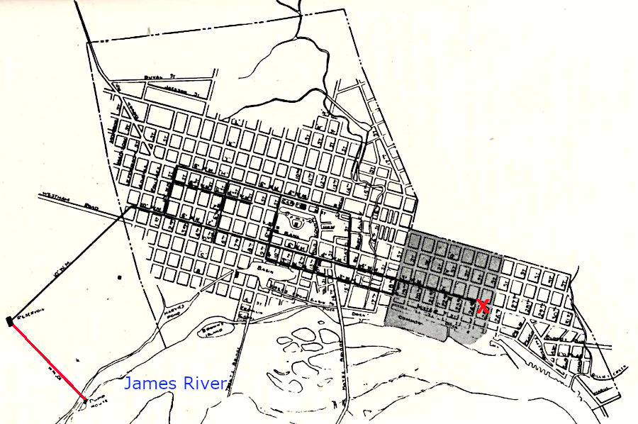
the pump house sent water uphill via pipeline (in red) to the Marshall Reservoir; other pipes sent water as far east as 24th Street (red X)
Source: City of Richmond, Watering the City of Richmond (p.29)
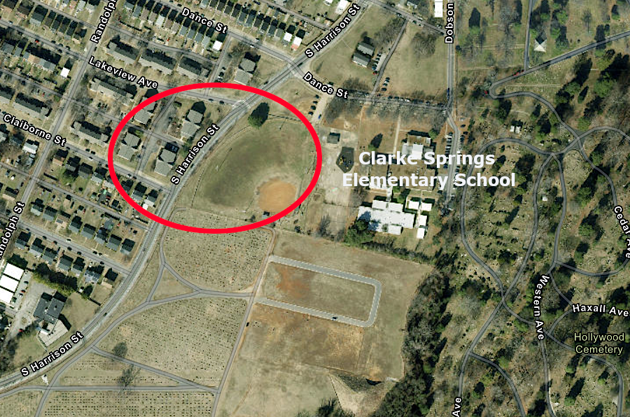
South Harrison Street now curves through the site of the old Marshall Reservoir between Hollywood Cemetery and Byrd Park
Source: ESRI, ArcGIS Online