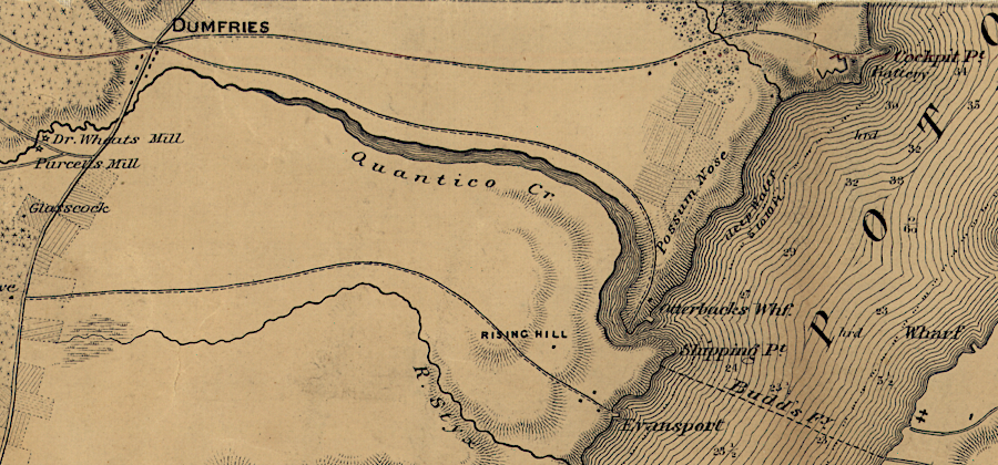
in 1862, the future site of Quantico was undeveloped
Source: Library of Congress, Map of n. eastern Virginia and vicinity of Washington ("McDowell Map," 1862)
in 1862, the future site of Quantico was undeveloped
Source: Library of Congress, Map of n. eastern Virginia and vicinity of Washington ("McDowell Map," 1862)
The Town of Quantico is located on the south bank at the mouth of Quantico Creek. When John Smith sailed up the Potomac River in 1608, he mapped the town of Pamacocack near Quantico Creek. It was ocupied by the Taux, whose main town where the werowance lived was at the mouth of the Occoquan River. Their paramount chief was the Piscataway tayac, who lived across the river in what eventually became the state of Maryland. The Native Americans along the Potomac River were displaced after Bacon's Rebellion in 1676.
The first English patents for land that ended up in Prince William County were filed in the 1650's. North of Little Creek, Marine Corps Base Quantico is located on land that was initially granted to Nicholas Martiau in 1654. The portion south of Little Creek was part of a 1657 land grant to Samuel Mathews, who was the colonial governor. The first Scottish immigrants arrived in 1686.1
A wooden church, an Overwharton Parish "chapel of ease," was constructed in 1667 at the site of the current Dumfries Cemetery. Reverend Alexander Scott, rector of Overwharton Parish between 1701-1738, purchased the Dipple house on what is now the military base and established his plantation there. The parish's main church was at Aquia; the current structure there was built in 1757.1
"History," Historic Dumfries, https://historicdumfriesva.org/about/history/ (last checked January 14, 2025)
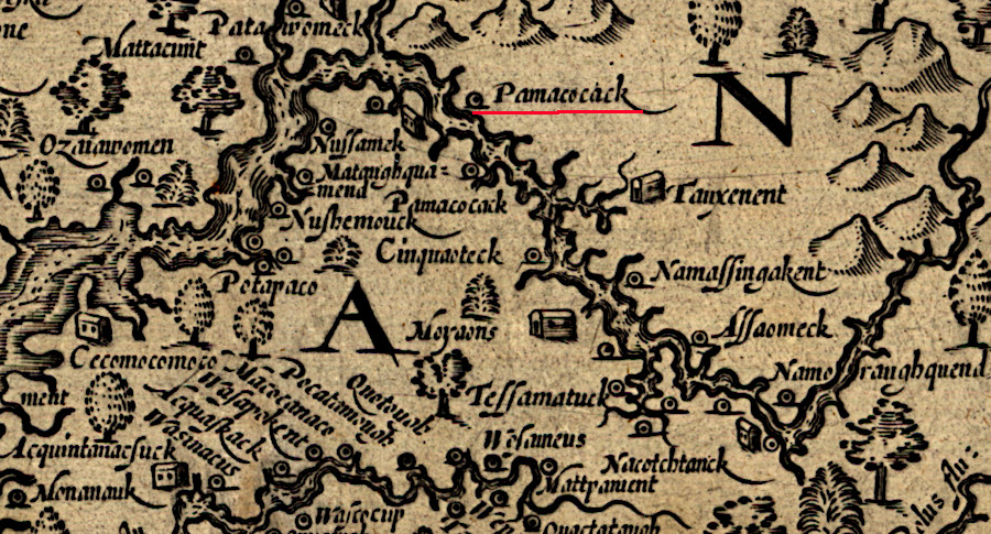
hen the first English rowed past Quantico Creek in 1608, they saw the town of Pamacocack
Source: Library of Congress, Virginia (by John Smith, 1624)
The area was used primarily as farmland and for forest products until the 20th Century. The colonial government mandated that tobacco warehouses be established to inspect hogsheads and prevent the export of "trash tobacco." The first at Dumfries was built in 1713. Scottish merchants were the primary buyers of tobacco from small plantations.2
An iron furnace, the Neabsco Iron Works, went into blast nearby in the 1730's. Trees around the iron furnace were converted into charcoal to smelt the iron ore.
The towns of Dumfries and Alexandria were established in 1749. The Ohio Company planned westward expansion across the Alleghenies, and settlement along the route to the Ohio River started on the banks of the Potomac River. Shipping to Dumfries was extensive initially, with ocean-going ships docking regularly until the American Revolution.
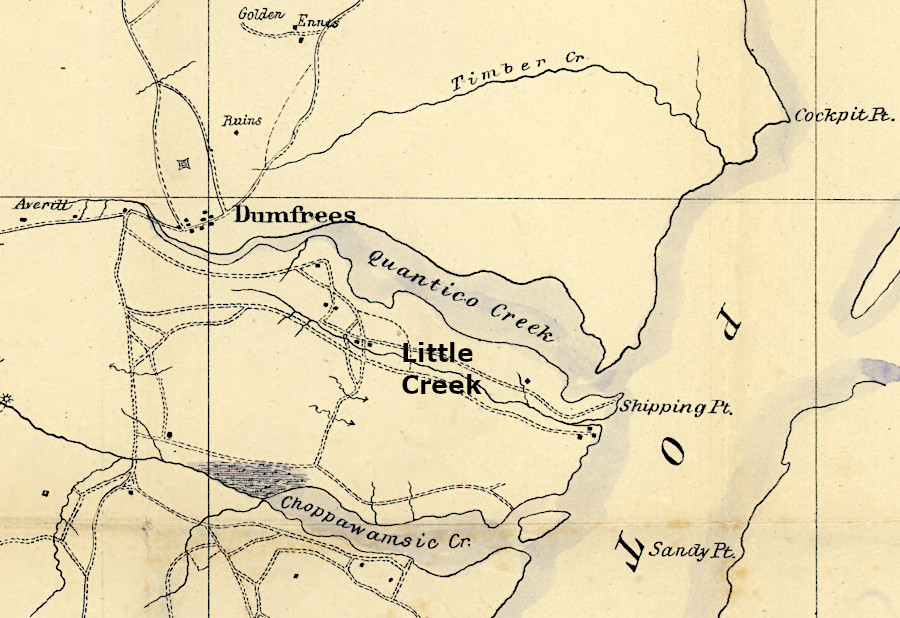
there were roads on each side of Little Creek in 1864
Source: Library of Congress, Central Virginia (1864)
The estuary of Quantico Creek became clogged with silt due to land clearing for farming and charcoal production. Soil erosion was substantial, ocean-going ships could no longer reach the docks at Dumfries, and it became just a minor local port.
The shipping channel was so clogged that in 1787 the leaders in Dumfries tried to establish two new villages closer to the mouth of Quantico Creek. Newport was planned on the northern side, and Carrborough on the southern edge near Evansport (now the modern-day town of Quantico). Both attempts were failures. People continued to live next to the road and taverns, while ships bypassed the shallow channel in Quantico Creek.
Alexandria captured the trade, which after the American Revolution was not so dependent upon tobacco exports. Alexandria's docks were in a Potomac River channel that washed silt downstream, so that town remained an active port for ships that sailed across the Atlantic Ocean and to the Caribbean.
For four and a half months during the Civil War, the Confederates blocked Union ships from steaming and sailing up the Potomac River to Washington DC. About 15 artillery batteries were built on the shoreline between Evansport and Freestone Point. Infantry companies built camps with rudimentary housing. Soldiers dug holes into the ground and built roofs on top; it was rough living.
The two largest batteries were at Shipping Point where the naval hospital is now located. The most effective batteries were at Cockpit Point north of Quantico where the channel was closest to the Virginia shoreline.
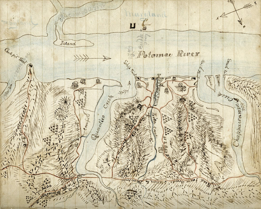
Evansport was a military base in 1861, before the US Marines arrived in 1917
Source: Tennessee Virtual Archive, Hurried sketch of Evansport, Virginia vicinity (by Private Samuel Sydney Gause, Jr., November 1861)
Confederate batteries at Evansport firing on Union supply vessels in October, 1861
Source: Navy Historical Center, CSS George Page (1861-1862)
On the Maryland side of the Potomac River, Union Maj. Gen. Joseph Hooker had 8,000 troops. Col. Thaddeus Lowe inflated his balloon so a Union soldier could map the Virginia shoreline and spy on Confederate operations. Colonel William F. Small ascended four times, rising up 700 feet, in order to sketch nine encampments and three completed batteries, with a fourth under construction in December 1861. Union ships were unable to use their cannon to displace the Confederates, and the Union Army was unwilling to launch an amphibious attack. The river blockade ended in March 1862, when the Confederates moved south to reinforce Richmond during the Peninsula Campaign.3
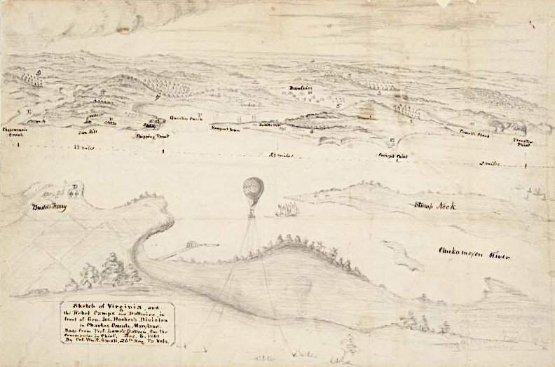
view of the Quantico shoreline in 1861 from a Union balloon on the Maryland side of Budd's Ferry
Source: Smithsonian Institution, More than Just a Map
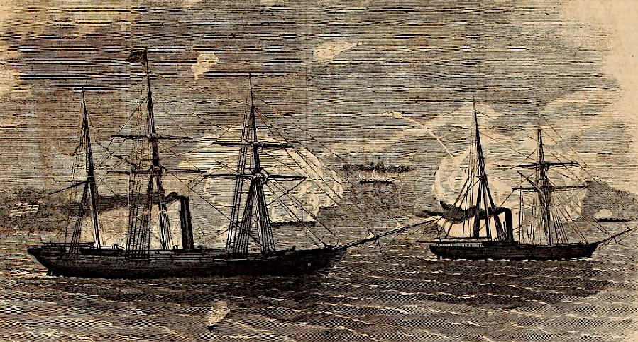
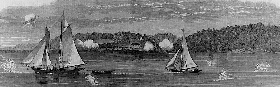
Union ships Seminole and Pocahantas engaging the Confederate batteries at Evansport
Source: Internet Archive, Harpers Weekly (November 2, 1861, p.701)
At the start of the blockade the Confederate schooner Martha Washington was anchored at the mouth of Quantico Creek, near the current boat dock in the town. Three small Union boats crossed the Potomac River in the early morning of October 11, quickly overpowered the lone sentry on the Martha Washington, and burned the ship before recrossing the river.
The Confederates moved a second ship, the George Page, from Aquia Creek to Quantico Creek. At night, it could steam into the Potomac River and harass the Union forces on the Maryland side. At day, however, it stayed in the creek to avoid being shelled by Union artillery. The Confederates soon moved the George Page to Chopawamsic Creek, where it was less exposed to enemy fire. Starting in February 1862 Union forces used Whitworth rifled cannons to land artillery shells among the Confederate positions at Evansport and Shipping Point.
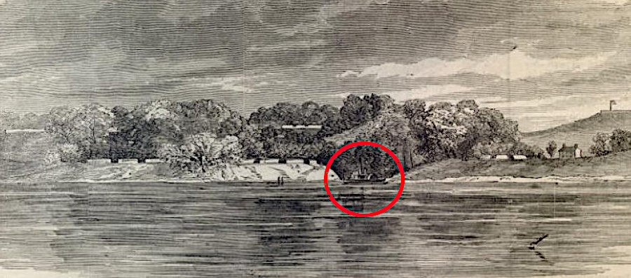
CSS George Page in Quantico Creek at Evansport
Source: HathiTrust, Harper's Weekly (November 23, 1861, p.742)
The Union army crossed the Potomac River occasionally with small groups of 10-15 men to conduct raids on the Confederates. The primary objective was to capture someone in order to obtain military intelligence by interrogating a prisoner. Confederates troops were often forced out of camp and aligned to repel an attack, but many time experienced just false alarms.
Union commanders were unwilling to risk a more-ambitious amphibious assault beyond the raids. Catturing an enclave around Quantico Creek would not provide a significant military benefit. Supplying a base from Maryland would
Not every interaction at Quantico was hostile:4
Until the start of the 20th Century, it was undeveloped farmland. Ship traffic went upstream to the headwaters of Quantico Creek at Dumfries, until that port silted in.
In 1872, railroads being built south from Alexandria and north from Fredericksburg met at Quantico Creek, finally providing a direct rail connection. Prior to the extension of the Pennsylvania Railroad south and the Richmond, Fredericksburg and Potomac Railroad north, freight and passengers had to travel on boats on the Potomac River between Washington and Aquia Creek.
Before World War I, the Quantico Company tried to develop the site as a tourist destination. It developed a hotel and dance pavilion, and even a sewer on one street at the mouth of Quantico Creek:5
Once the war broke out in Europe, the US Marines recognized they needed a base on the East Coast large enough to train 7,000 Marines. The Federal government leased 5,300 acres owned by the Quantico Corporation in 1917, purchased the land in 1918, and established what is now Marine Corps Base Quantico. The Quantico Company hotel became the officers quarters. The community incorporated in 1927 and received a town charter from the General Assembly in 1934. It became the only town in the United States completely surrounded by a military installation.6
The train station is located at the southwest edge of the town. Despite the limited public access due to Marine Corps Base Quantico security, the east platform was extended and a permanent west platform constructed in 2024. Two pedestrian bridges provide pedestrians a safe way to cross the tracks. Creation of an island platform allows passengers to access Amtrak and Virginia Railway Express (VRE) trains on all three tracks.
The upgrades were part of the installation of the $75 million Arkendale to Powell's Creek Third Track Project, a component of CSXT's Atlantic Gateway initiative. The third track reduced conflicts between passenger and freight trains.7
Quantico is the only town in the United States that is completely surrounded by a military base. Not surprisingly, the crime rate is low.
Residents, visitors, employees, Amazon delivery truck drivers, and everyone else must pass through Marine Corps security in order to get into town. Businesses such as the seven barbershops cater primarily to Marines stationed at the base; few customers are willing to drive through the delay at the entrance gates in order to shop in Quantico.
The mayor said in 2025:8
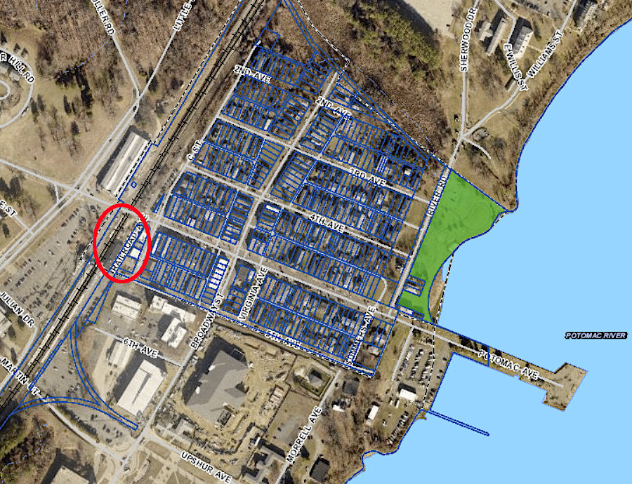
the train station is at the edge of the Town of Quantico
Source: Prince William County, County Mapper