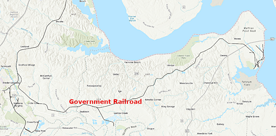
the US Navy operated the Government Railroad to Dahlgren between 1943-57
Source: ESRI, ArcGIS Online
the US Navy operated the Government Railroad to Dahlgren between 1943-57
Source: ESRI, ArcGIS Online
In 1918, the US Navy purchased 4,000 acres in King George County to test naval guns. The Potomac River was more suitable there than at the Indian Head Proving Ground in Maryland, providing a longer range to test more-powerful weapons.1
Steamships provided supplies and enabled personnel to move back and forth to Washington. The site was so isolated that when officer's wives traveled by car to shop in Fredericksburg or Washington, they took along carrier pigeons. If the vehicle bogged down or was disabled on the road, the pigeon would be released to alert the base that a rescue mission was needed.2
Roads in King George and Stafford counties were paved in the 1920s and 1930s, but the US Navy found it difficult to transport heavy ammunition and large gun barrels to Dahlgren for testing. At the facility, railroad tracks were constructed to move heavy items from the docks on the Potomac River to testing and storage locations.
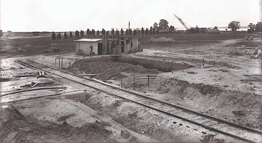
the US Navy built short tracks to carry heavy ordnance, gun barrels, and steel plate from the Potomac River dock to storage and testing sites, before the Government Railroad was completed
Source: Navy Sea Systems Command, Naval Surface Warfare Center Dahlgren Division, Virginia - Dahlgren Ordnance History - Plate Battery
The facility's name was changed to Naval Proving Ground, Dahlgren in 1932, and it was designated as the Navy's principal proving ground. Every major naval gun and all ammunitions was tested there, including battleship guns that fired shells at steel plates to test resistance to armor-piercing weapons. The biggest gun ever tested by the US Navy was assembled in 1941, and all 559,974 pounds of the components had to be shipped by water to Dahlgren.3
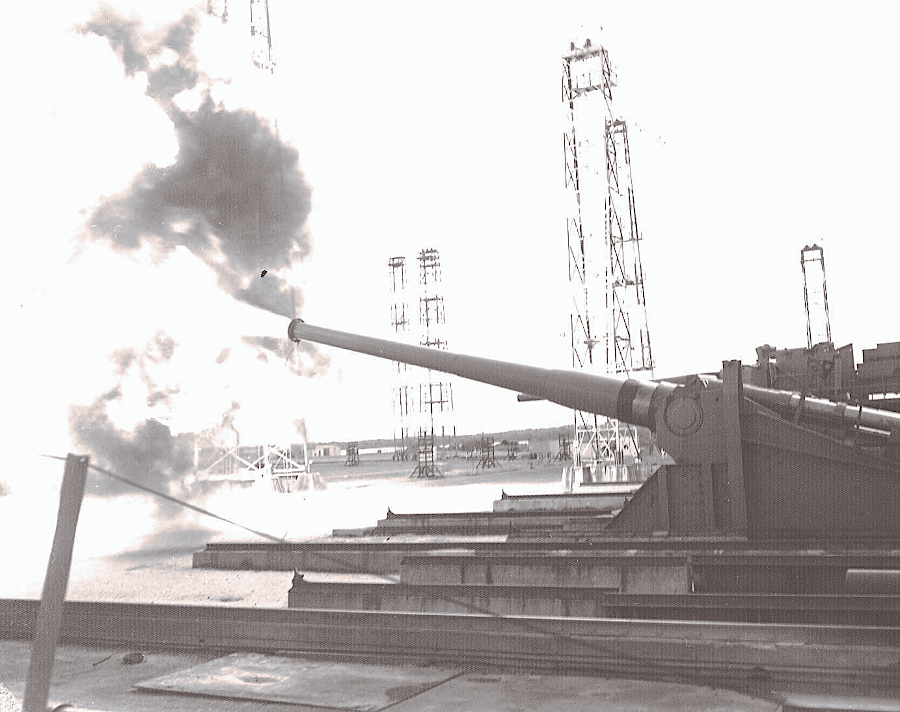
the US Navy tested guns at Dahlgren without a railroad connection until World War II
Source: Navy Sea Systems Command, Naval Surface Warfare Center Dahlgren Division - 16" Gun Firing
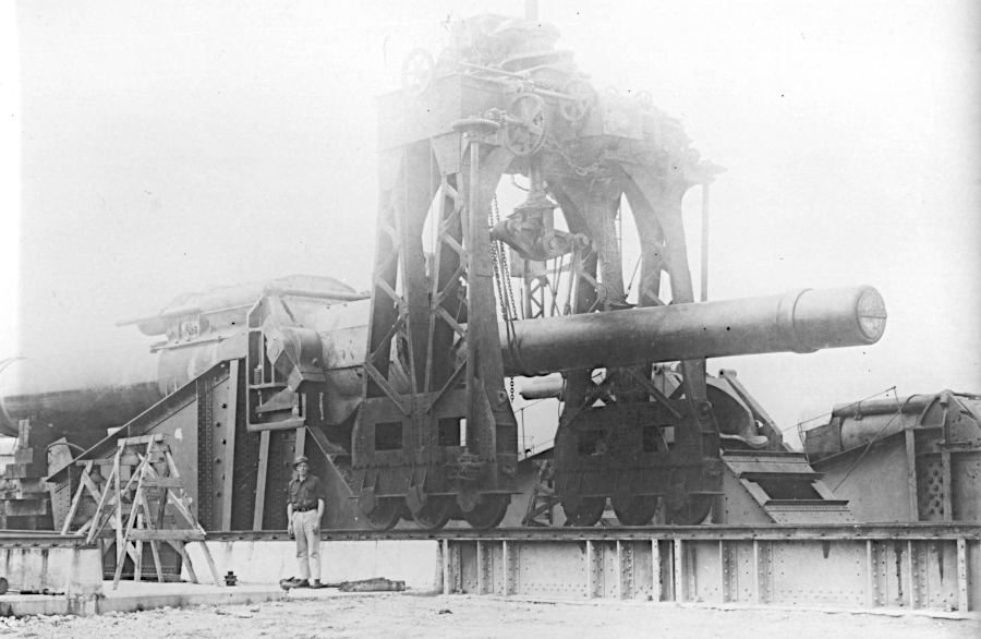
the US Navy assembled its largest gun at Dahlgren, weighing over 275 tons, before the railroad simplified delivery of components
Source: Navy Sea Systems Command, History of the U.S. Navy’s Only 18-inch Gun
The staff at Dahlgren swelled from 254 in 1939 to 1,471 in 1944. The need for better access was clear even before the start of World War II, particularly in the winter when ice the river interrupted transportation of gun barrels from the foundry in Washington to Dahlgren for testing.
Starting in 1939, the US Navy began to purchase a 50' wide to 100' wide, 28-mile long right-of-way for the Government Railroad. It stretched from the Richmond, Fredericksburg and Potomac (RF&P) at Cool Spring, just north of Fredericksburg Railroad, to Dahlgren.
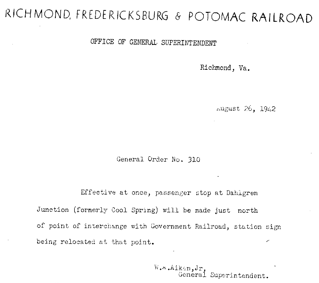
the Richmond, Fredericksburg and Potomac Railroad renamed Cool Spring as Dahlgren Junction
Source: Richmond, Fredericksburg and Potomac Railroad , General Order No. 310
Surveyors had planned to cross Ferry Farm where George Washington had lived as a young child, and also Sherwood Forest Farm. It had been owned by Washington's mother, and in 1939 was the property of an influential vice-president of General Motors. The railroad was re-routed to avoid Sherwood Forest Farm, but ended up crossing a portion of Ferry Farm. Today the portion of the Ferry Farm open to the public is on the opposite site of Route 3 from the railroad track.
The African American congregation at Little Ark Baptist Church received less consideration. The track was constructed through the cemetery, rather than aligned to avoid it. At the time, when Virginia's laws enforced racial segregation, the cultural sensitivity of the US Government was limited.
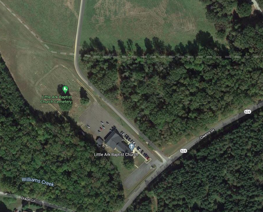
the Government Railroad (now Dahlgren Railroad Heritage Trail, shown with dotted line) was constructed through the cemetery of the Little Ark Baptist Church
Source: GoogleMaps
Construction was completed in 1942. The US Navy designed the railroad and hired the contractors. Railroad ties were produced at a local sawmill, with trees cut on the adjacent hill and rolled down for processing. Ballast for the railbed was crushed at a new plant at a quarry in Sealston. One worker who helped build the railroad later described how ballast and ties were installed:4
the US Navy constructed the Government Railroad in 1941-42, starting at Cool Spring (now Dahlgren Junction)
Source: ESRI, ArcGIS Online
The Government Railroad was used primarily for shipping freight. Only one train ran at a time, so no signaling system was required to avoid collisions. Passengers traveling in the Edwards railcars referred to taking the Doodlebug Train.
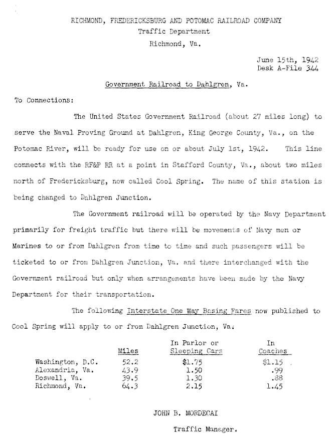
the US Navy opened the Government Railroad in 1942, with a connection to the Richmond, Fredericksburg and Potomac Railroad at Dahlgren Junction
Source: Government Railroad to Dahlgren Junction (June 15, 1942)
After World War II, no new battleships were constructed. Testing of large, heavy guns at Dahlgren was replaced with testing of missiles and use of computers for directing weapons. In 1957, the US Navy stopped operations on the Government Railroad.
In 1963, the Richmond, Fredericksburg and Potomac (RF&P) Railroad sought to purchase the first 1.3 miles of track to provide service to Republic Lumber. The US Government chose to declare the entire line to be surplus property, and offered it first to King George and Stafford counties. They declined to pay the proposed price for all the track within each jurisdiction, but Stafford County did buy the 1.3 mile stretch desired by the Richmond, Fredericksburg and Potomac Railroad.
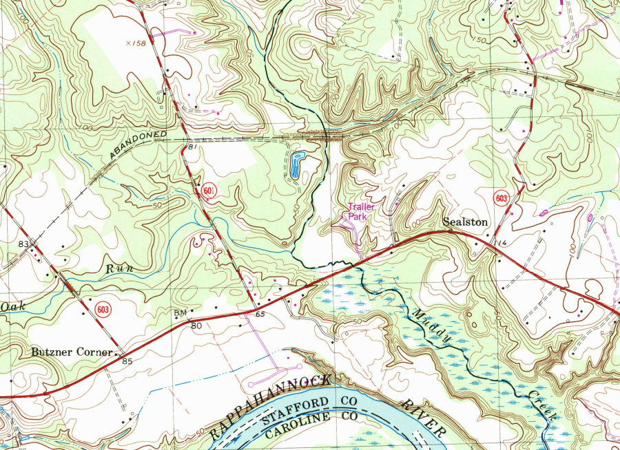
operations ceased on the Government Railroad in 1957, but the western half to Sealston was restored to service as the Dahlgren Branch of the Richmond, Fredericksburg and Potomac (RF&P) Railroad
Source: US Geological Survey (USGS), Passapatanzy, VA 1:24,000 topographic quadrangle (1966)
At auction, the Richmond, Fredericksburg and Potomac Railroad purchased the remaining portion of the Government Railroad, and Stafford County sold its 1.3 miles to the railroad. The expectation was that new industry, beyond Republic Lumber, could be recruited to locate along what was renamed the Dahlgren Branch. The Solite Corporation opened a sand and gravel operation on the Rappahannock River south of Sealston in 1969, and the Richmond, Fredericksburg and Potomac Railroad placed 11 miles of track back into operation to serve that business until it closed in 1989.
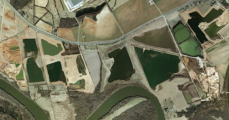
the Richmond, Fredericksburg and Potomac (RF&P) Railroad provided low-cost transportation for sand and gravel operations south of Sealston
Source: GoogleEarth
No industry located on the eastern half of the line past Solite. When the Northern Virginia Shooting Facility purchased land on either side of it in 1970, it aligned shooting ranges so anyone traveling on the right-of-way would have been at risk. In 1990, Richmond, Fredericksburg and Potomac Railroad removed the rails from the section in King George County east of the landfill and Birchwood power plant. A year later, CSX acquired the Richmond, Fredericksburg and Potomac Railroad. In 1993, it sold the right-of-way.
Plans to sell the stretch to the fertilizer company at Sealston were not finalized. Adjacent property owners declined to pay for vacant land in their back yards. A single local resident, who had previously chaired the King George County Planning Commission, ultimately purchased the right-of-way at the end of 1997. He anticipated the route could be converted into a rail-to-trail project, but knew there was local opposition.
In 1992 and 1993, the local member of the House of Delegates introduced a bill in the General Assembly for the trail to be donated to the state by the Conservation Fund, which had arranged to purchase it from the private owner. The Virginia Department of Conservation and Recreation would manage the trail for public use, together with nearby Caledon Natural Area. Local residents opposed the bill, and it failed to pass.
The county administrator in King George County supported the rails-to-trails in 1994, and the county applied for a Federal grant. However, the grant was not available that year. When requested to support another grant application in 1997, the King George Board of Supervisors declined to act. Local opponents, including influential landowners concerned about privacy and long-time residents concerned about rapid population growth transforming the area, complained that the trail supporters were out-of-county residents.
The Virginia Department of Conservation and Recreation supported the rails-to-trails proposal, which would connect to Caledon Natural Area (now Caledon State Park), and included it in the Virginia Outdoors plan starting in 2001. Local support from the local Sierra Club could not overcome opposition by the Board of Supervisors at the time.
In 2003, the individual trail owner sold a portion of it next to Route 301 for a commercial development. In 2006, he sold the remaining 15.7 miles to David Brickley for $200,000 while retaining the rights for utility easements. Brickley had been a member of the House of Delegates, then served as Director of the Virginia Department of Conservation and Recreation in 1997-2001 during Governor Jim Gilmore's administration.
With David Brickley's strong support, the Friends of the Dahlgren Railroad Heritage Trail formed and opened the trail to limited public use in 2006. The Friends of the Dahlgren Railroad Heritage Trail promised to create a bypass at Little Ark Baptist Church, and to transfer back to that congregation the land taken from the cemetery.
Special arrangements with the Northern Virginia Shooting Facility included posting trail watchers who stopped the firing when hikers passed through, and then construction of a temporary bypass. However, in 2015 the Northern Virginia Shooting Facility publicly opposed efforts to transfer the trail to state ownership and incorporate it into Caledon State Park. That led to the Friends of the Dahlgren Railroad Heritage Trail returning to use of the original route.
Local opposition may have reflected a small minority of residents, but was vocal and threatening at times. Trees were cut to block the trail, trash dumped to block hikers, and during one public event skeet shooters peppered the trees above the hikers.
Local politics changed in 2015, when a supporter of the Dahlgren Railroad Heritage Trail project was elected to the King George Board of Supervisors. At the General Assembly, however, a 2016 bill blocked the state from accepting ownership of the trail even as a gift. The National Park Service still included it as part of the Potomac Heritage National Scenic Trail. In 2018 King George County agreed to make the trail part of the county park system, and to advocate for inclusion of the trail in Caledon State Park.5
The delay in obtaining support from local elected officials and property owner for creating the Dahlgren Railroad Heritage Trail was not the first in Virginia. Creation of the Virginia Creeper Trail in Washington County was delayed by opposition from the Board of Supervisors there, and by adjacent landowners who anticipated getting control of the right-of-way at no cost. Federal officials purchased half of the abandoned Virginia-Carolina Railroad right-of-way in 1978, but the remaining half was not acquired until 1981-82.
The Virginia Creeper Trail ended up becoming a signature attraction and an economic enhancement for the area, with half of the visitors coming from over 4 hours away. Such tourists buy food and gas, and the 10% of trail users who stay in hotels stimulate local business.6
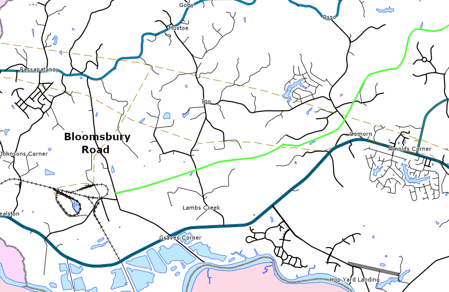
Bloomsbury Road is the western end of the Dahlgren Railroad Heritage Trail, next to the Birchwood Power Plant
Source: King George County, Geographic Information System (GIS)
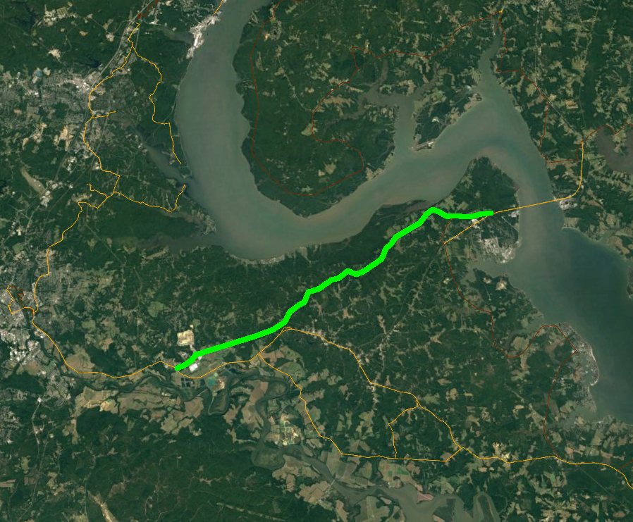
the abandoned section of the Government Railroad has been identified as a component of the Potomac Heritage National Scenic Trail
Source: National Park Service, Potomac Heritage National Scenic Trail (in GoogleEarth)