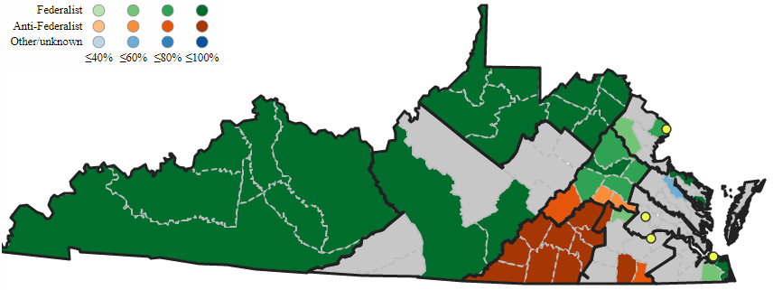
in 1789, Virginia elected seven Federalists (green jurisdictions) and three Anti-Federalists candidates (brown) to the House of Representatives
Source: Mapping Early American Elections, 1st Congress: Virginia 1789
In the Continental Congress which met between 1774-1788, Virginia had one vote. The 13 separate states could send as many representatives as they wished to the Continental Congress, but decisions were made by a total of 13 votes.
After ratification of the US Constitution in 1788, all states elected two Senators. The number of members elected to the US House of Representatives varied, based on the population of the state. Virginia elected 10 of the 65 members in the House of Representatives during the first Congress that began meeting in April, 1789. The number of members elected from Virginia to the House of Representatives has varied since then, and is currently 11.1
in 1789, Virginia elected seven Federalists (green jurisdictions) and three Anti-Federalists candidates (brown) to the House of Representatives
Source: Mapping Early American Elections, 1st Congress: Virginia 1789
The two Senators serving in the Congress from Virginia represent the entire state for their six-year term. They campaign throughout Virginia every six years for election, and visit nearly all of the state's 95 counties and many of the cities in the process because all votes in the state count towards the election of a Senator. For statewide races, one vote in Halifax County is as good as one vote in Loudoun County.
The same applies to races for Governor, Lieutenant Governor, and Attorney General every 4 years. Candidates for those three offices spend most of their time and money campaigning where voters are concentrated, so most efforts are concentrated in Northern Virginia, the Richmond area, and Hampton Roads.
Roanoke has television stations that reach much of southwestern Virginia, and Lynchburg TV stations reach rural areas in Southside, so brief visits to those cities generate valuable media coverage. In addition, every candidate for one of Virginia's 5 statewide offices (two senators, Governor, Lieutenant Governor, and Attorney General) will appear in the Appalachian Plateau counties occasionally to show their commitment to that region.
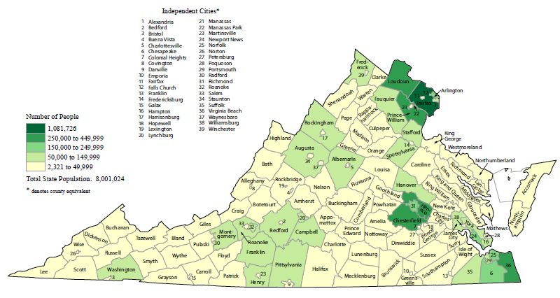
"Total Population by County" in 2010 shows Virginia's voters are concentrated in Northern Virginia, Richmond area, and Hampton Roads
Source: Bureau of Census Thematic Maps, Total Population by County: 2010
In contrast, each of the 11 members of the US House of Representatives represent less than 10% of the state's population for their shorter term of office. Every two years, they campaign in just their district; get-out-the-vote efforts are held only within the district. Campaign events held outside the Congressional District are typically fundraisers, often in Richmond and Northern Virginia but also in other states.
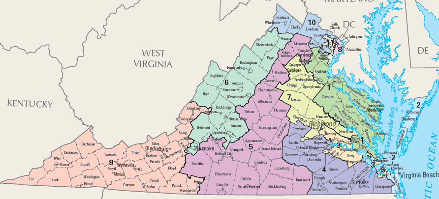
boundaries of Congressional Districts, defined after 2010 Census provided data for redistricting
Source: US Geological Survey, National Atlas
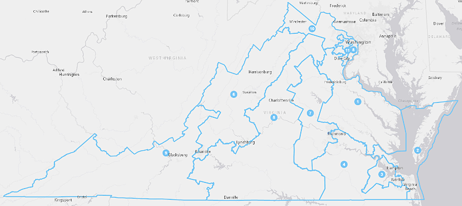
Candidates for all of the House of Representatives have a narrower focus than candidates for the five statewide offices. District boundaries shape the priorities of members of the House of Representatives. Odds are, in any Congress the elected member to the House of Representatives from the Sixth District (including much of the Shenandoah Valley) will care more about the budget and regulations from the US Department of Agriculture than the member from the Tenth District (including urbanized Arlington/Alexandria). The elected member to the House of Representatives from the Ninth District (including much of Southwestern Virginia) will normally care more about coal mining than the Representative from the Eight District (including Fairfax/Prince William suburbs).
the 8th, 10th, and 11th Congressional Districts are in Northern Virginia, but the 9th District has been in southwestern Virginia for over a century
Source: US Geological Survey, Congressional Districts - 113th Congress
Who in the state's delegation to the US Congress cares the most about Navy contracts for shipbuilding and repairs, or how many aircraft carriers will be based on the East Coast?
The geography of the 11 districts for the House of Representatives affects campaign styles. In Northern Virginia, a candidate for the 8th, 10th, or 11th districts can visit a high percentage of the precincts easily in a day, after fighting through traffic jams. Candidates can purchase advertising on one radio station such as WTOP and reach the entire district with one "buy."
In contrast, candidates in the 9th District have to drive for a half-day just to get from Cumberland Gap to Roanoke. Using radio and TV in a campaign requires more complex calculations regarding what stations reach which geographical areas, in addition to the standard assessments of what type of voter listens to country vs. Top 40 music.
Boundaries of Congressional districts are redrawn every 10 years, after the decennial census calculates the population within each district. Boundary lines are moved in the redistricting process to ensure each of the 11 districts contains the same number of people, in order to comply with "one person - one vote" requirements established by US Supreme Court decisions.
Until 2021, the General Assembly redrew the boundaries, and the political party in control of the legislature had the opportunity to enhance their party's potential success by gerrymandering the districts. The US Supreme Court ruled in 2019 that Federal courts had no authority to intervene when highly-partisan district boundaries were drawn by state legislatures. On occasion, as in 2016, district boundaries are redrawn between a census in order to comply with a judge's ruling that boundaries illegally discriminated against racial minorities.2
After voters approved an amendment to the state constitution in 2020, a bipartisan Redistricting Commission had the responsibility for determining the new shapes of Congressional districts.
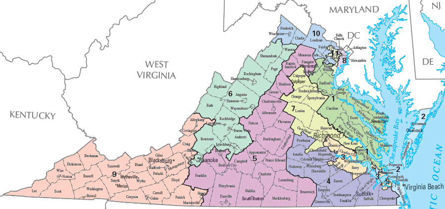
a Federal court required redrawing Congressional district boundaries between the standard redistricting after 2010 Census and 2020 Census
Source: Virginia Redistricting Commission, Current Congressional Districts (as of January 7, 2016 after court-ordered redistricting)