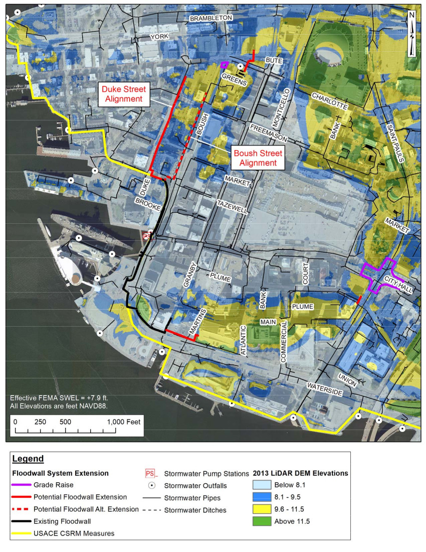
the Corps of Engineers plans to extend the existing floodwall (black line) east to Campostella Road and west to The Hague (yellow line)
Source: Norfolk Floodwall Extension Project, Proposed Floodwall Map
the Corps of Engineers plans to extend the existing floodwall (black line) east to Campostella Road and west to The Hague (yellow line)
Source: Norfolk Floodwall Extension Project, Proposed Floodwall Map
Norfolk is at high risk of increased flooding as sea levels rise, land subsides, and storms become more intense. Nuisance flooding, particularly during "king tides," is predicted to increase.
The city, in partnership with the US Army Corps of Engineers, has developed a $1.6 billion proposal to construct more storm barriers around downtown. A half-mile seawall as completed in 1971 to protect the western edge of downtown against rising water in the Elizabeth River, an area now occupied by the Nauticus complex and the World Trade Center.
The proposal is to raise that seawall and extend it both east and west. Other extensions of the seawall could add additional protection east of Boush Street and north of Waterside Drive.
In Phase 1, the height of the current seawall would be raised two to three feet. In Phase 2, the seawall would be extended north up the median of Boush Street and eastward along Waterfront Drive. A Phase 3 would raise St. Paul's Boulevard, including the sidewalks, by four inches to protect against water intruding from the Harbor Park area.
The ultimate dream was to extend the seawall north past The Hague, as far as Sentara Norfolk General Hospital. That would protect the Chrysler Museum. An eastward extension to Campostella Road would protect the casino and ballpark at Harbor Park.
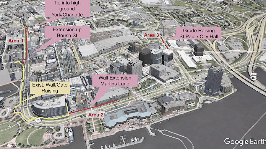
in Phase 2, the existing floodwall would be extended north up Boush Street and east along Waterfront Drive (red lines)
Source: Norfolk Floodwall Extension Project, Downtown Floodwall Newsletter (Issue 1, January 2022)
Norfolk officials proposed constructing new seawalls, tide gates, and pump stations to protect existing developed parcels near the water's into green open spaces where occasional flooding was acceptable. Buildings would be removed at or near the end of their economic life, rather than replaced with new structures. The land would be purchased by government agencies, using funding that otherwise would be invested in "gray" infrastructure such as seawalls to prevent water from moving inland.
A spokesperson for the Chesapeake Bay Foundation suggested that the emphasis on flood control was misplaced, and more "green" infrastructure should be incorporated into the planning. He commented:2
Federal funding for the flood control project needed to be matched by state and/or local funding. The Norfolk City Council establish a dedicated tax to fund climate projects, allocating $0.01 of the real estate property tax. The "resilience penny" was projected to raise $1.8 million each year. As described in the Virginia Coastal Resilience Master Plan:3