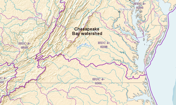
colonial settlement was faster in the Chesapeake Bay watershed (north of blue line), where agricultural products could be carried by water from a wharf on the Chesapeake Bay to markets in the Caribbean or Europe
Source: ESRI, ArcGIS Online
colonial settlement was faster in the Chesapeake Bay watershed (north of blue line), where agricultural products could be carried by water from a wharf on the Chesapeake Bay to markets in the Caribbean or Europe
Source: ESRI, ArcGIS Online
The watershed divides in southeastern Virginia are subtle, but significant. Most of Dismal Swamp is naturally in the Roanoke River watershed, though ditches and canals have altered local hydrography and some water from Lake Drummond could drain to the Chesapeake Bay now.
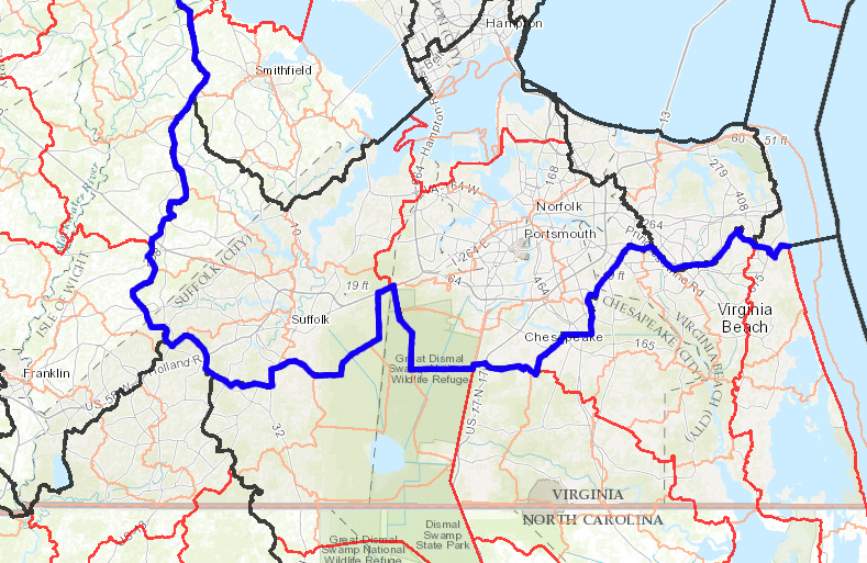
The southern part of the cities of Virginia Beach, Chesapeake, and Suffolk are not in the Chesapeake Bay watershed.
Watershed boundaries shape modern pollution control efforts. The initiative to "Save the Bay" includes regulations that limit nutrients discharged by wastewater treatment plants, incentives for adopting Best Management Practices in agricultural areas, and controls on stormwater runoff could be applied city-wide. However, in the southern portion of the three cities of Virginia Beach, Chesapeake, and Suffolk, those water quality tools will impact Back Bay and the Albemarle/Pamlico Sound rather than the Chesapeake Bay.
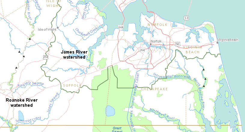
drivers on Route 58 will cross the watershed divide separating James River/Roanoke River watersheds in the City of Suffolk
Source: US Geological Survey (USGS), National Atlas Streamer
"Save the Bay" license plates help fund the cleanup of the Chesapeake Bay. That funding could be used for projects on the Northern Neck and even in the Shenandoah Valley, but not the counties west of I-95 bordering North Carolina. None of Virginia on that border drains into the Chesapeake Bay - not even the southern part of Virginia Beach. Drive south on US17 on the eastern edge of the Dismal Swamp in the city of Chesapeake, and you'll see the same signs announcing that you are "Leaving the Chesapeake Bay Watershed" - just like the sign you see on Interstate 81 north of Roanoke...
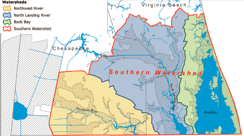
The North Landing River west of Back Bay runs due south to Currituck Sound. Virginia's rivers in the state's southeastern corner (including the Blackwater, the Nottaway, and the Meherrin) drain into the Chowan River and then the Albemarle Sound in North Carolina, rather than into the Chesapeake Bay.
Mother Nature did not provide a natural water connection between the land along Virginia's southern border and the Chesapeake Bay. Two canals were dug to facilitate shipping of tobacco, lumber, and other products across the watershed divide. The canals enabled farmers living along the Roanoke River, as well as the Blackwater, the Nottaway, and the Meherrin rivers, to get better prices by exporting via the ports on the Chesapeake Bay.
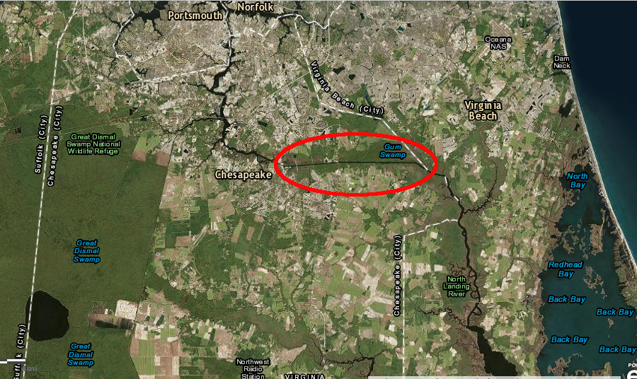
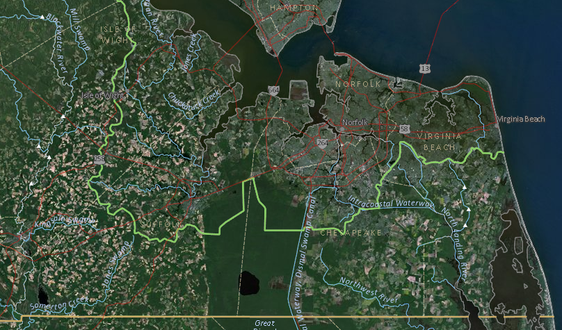
the Atlantic and Chesapeake Canal, maintained today by the US Army Corps of Engineers as the Inland Waterway, still crosses the watershed divide between the North Landing River and the Elizabeth River
Source: ESRI, ArcGIS Online
Most of Southside Virginia does not drain into the Chesapeake, and this was a factor in the slow development of the area in colonial times. Planters on the Eastern Shore, and on the west side of the bay in areas known as the Peninsula, the Middle Peninsula, and the Northern Neck, had direct access to international transportation. English ships could sail directly to wharfs in tidewater Virginia, load tobacco, and return home with minimal delay.
Tobacco farmers in Lunenburg and Brunswick counties, however, had to haul their crops across several rivers, in the days when roads were poor or non-existent. The physical geography of the colony delayed settlement and reduced the value of the land sold in those watersheds, compared to the Chesapeake Bay counties.
Watershed boundaries are almost never straight lines - but many of Virginia's political boundaries are often straight lines, defined by survey coordinates. Virginia's southern border was intended to be straight, forcing surveyors ignore natural contours and march though the Dismal Swamp and across the New River. There is a bump in Virginia's southern boundary east of Bristol, where a boundary dispute was caused in part by the difficulty of surveying in the rugged topography of the highest part of Virginia just south of Mount Rogers, but the political boundary ignores physical features in order to follow a line of latitude written in colonial charters during the 1600's.
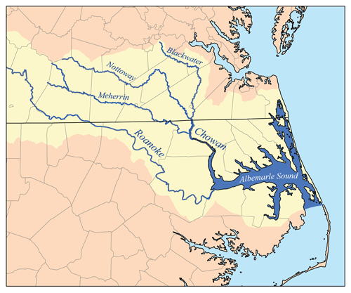
south of the Chesapeake Bay watershed, the Blackwater, Meherrin, and Nottoway rivers drain into the Chowan River
Source: Wikipedia, List of Rivers of Virginia
much of the region south of the Chesapeake Bay watershed is known as Southside Virginia, but the term Hampton Roads is most often applied to the eastern portion within the cities of Virginia Beach, Chesapeake, and Suffolk
Source: ESRI, ArcGIS Online