
Philpott Lake extends into Henry, Patrick, and Franklin counties
Source: ESRI, ArcGIS Online
Philpott Lake extends into Henry, Patrick, and Franklin counties
Source: ESRI, ArcGIS Online
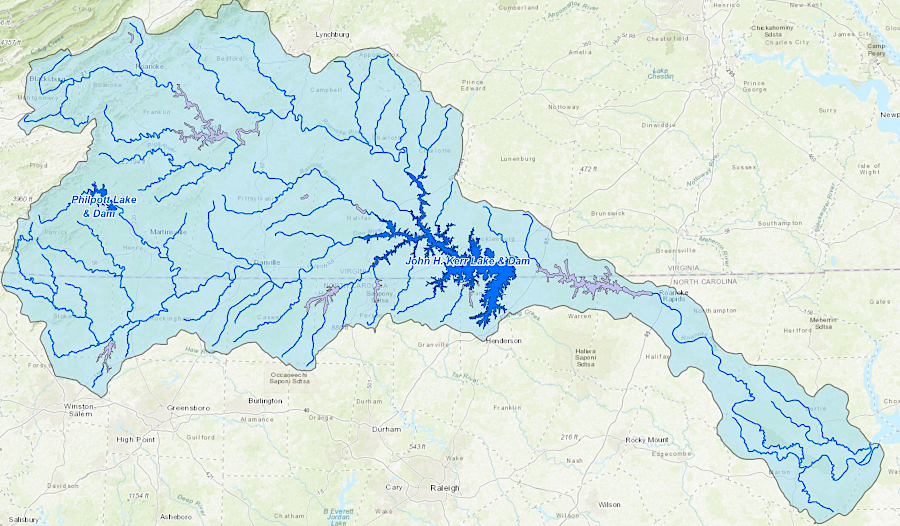
The US Army Corps of Engineers completed Philpott Dam across the Smith River in 1952 and finished building the powerhouse a year later. Primary objectives were to limit flooding in the Roanoke River basin and to generate electricity. Philpott Dam was authorized in 1944 after damaging floods in 1940 that had been triggered by 14-16 inches of rainfall. The new reservoir flooded 3,000 acres of forested land in Henry, Patrick, and Franklin counties.
Though the John H. Kerr, Leesville, Smith Mountain, Gaston, Roanoke Rapids, and Philpott Dam were justified primarily for flood control on the Roanoke River, they also provided recreational opportunities. An update to the Philpott Lake Master Plan in 2022 proposed reclassifying much of the Federal land around the lake as Multiple Resource Management Lands, a designation that prioritized us for low-density recreation and wildlife habitat.1
Philpott Dam was constructed across the Smith River as part of a major effort to control floods in the Roanoke River watershed
Source: US Army Corps of Engineers, Philpott Lake
The lake covers portions of the Tutelo-Saura Path, and the Saura-Saponi Trail used by Native Americans before the arrival of English colonists. Settlers expanded on those paths to go from the valley of the Roanoke River to the Piedmont in North Carolina. The colonist's "Great Road" crossed the Smith River just downstream from Philpott Dam.
By 1905, A.B. Philpott had opened a store where Town's Creek met the Smith River. The site developed when the Virginia Ore & Lumber Company built a standard gauge railroad up the Smith River to haul iron and timber from Fayerdale, which is now in Fairy Stone State Park, to the Norfolk and Western Railway's "Pumpkin Vine" line at Philpott. From Philpott, the Norfolk and Western Railway carried iron ore to furnaces in Pulaski, and that pig iron was used in the Roanoke foundries.2
On May 24, 2020, heavy rainstorms caused water levels to rise enough for water to flow over the spillway for the first time in the dam's history. A landslide just downstream of the dam damaged the powerhouse and other infrastructure, and power generation stopped for six years. Bank stabilization was attempted, but was not fully successful. As reported in the Martinsville Bulletin:3

a landslide on May 24, 2020 knocked offline the hydropower facilities at Philpott Dam
Source: US Army Corps of Engineers, Philpott Safety Mudslide
The $20 million repair project including finally stabilizing the hillside and upgrading the two generators. After an "arc flash" fire in the powerhouse in 2016, only one generator had been operational. After completion, the powerhouse could deliver as much as 19 megawatts compared to the previous 15 megawatts.
None of that electricity was sold to customers in Henry County, the site of Philpott Dam. The US Army Corps of Engineers delivered the electricity to Appalachian Power for distribution, and it did not service the county.4
Source: US Army Corps of Engineers, Philpott Safety Mudslide