Lake Accotink
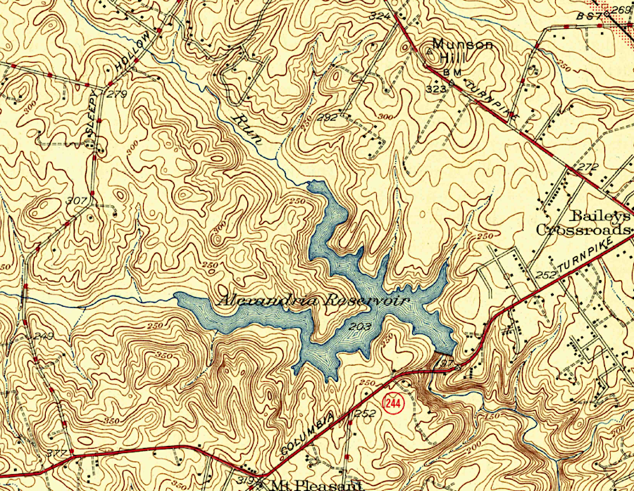
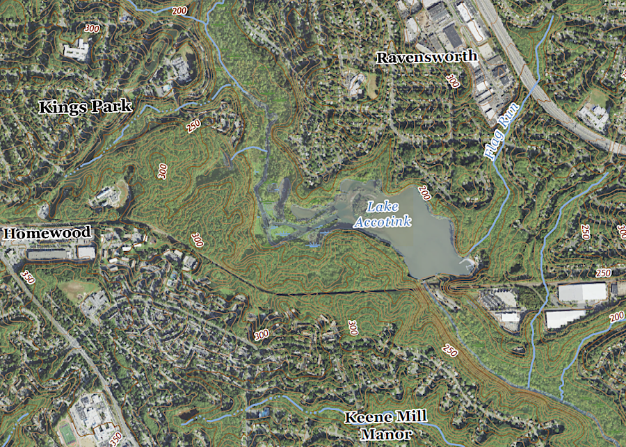
compared to 1945, today the watershed of Lake Accotink has a high percentage of impervious surfaces in modern subdivisions
Source: US Geological Survey (USGS), Annandale, VA 1:31,680 topographic quadrangle (1945), Annandale, VA 1:24,000 topographic quadrangle (2022)
The US Army constructed Camp A. A. Humphreys in 1917 where William Fairfax had built his Belvoir manor house in the 1700's. The Federal government had purchased land there in 1910 for a planned penitentiary. The property was transferred to the military in 1912 because the penitentiary site was moved to Lorton. Camp Humphreys was named after Major General Andrew A. Humphreys, the Army's Chief of Engineers between 1866-79.
Camp Humphreys was located in a rural area in Fairfax County without any public utilities. Between 1912-1917, when the site was home to the Engineer School and used as a summer camp and rifle range to train soldiers at Washington Barracks in Washington, DC, wells supplied the needed drinking water. By Fall 1918, as the US Army expanded during World War I, there wre 25,000 soldiers based at Camp Humphreys.
To create a water supply reservoir sufficient for the military base renamed Fort Humphries, the US Army Corps of Engineers built the concrete Springfield Dam across Accotink Creek and created Lake Accotink. It was 23 feet deep, covering 110 acres. Lake Accotink was located on land originally patented by William Henry Fitzhugh for his Ravensworth plantation, and owned at one time by three of Robert E. Lee's children. The Federal government built Lake Accotink without purchasing the land; instead, it was leased from the Lee family.
After World War I ended, few soldiers use Fort Humphreys. In 1922 the military engineers blasted a hole in Springfield Dam. That ensured a dam break would not trigger a flood that could wash out the trestle of the Richmond, Fredericksburg and Potomac (RF&P) Railroad. After just four years, the first Lake Accotink disappeared. Just enough water remained behind remnants of the dm to provide a swimming hole for local boys.
President Franklin D. Roosevelt renamed Fort Humphreys as Fort Belvoir. The base was restaffed with soldiers during World War II and a new dam was constructed in 1943. That dam, still intact, created modern Lake Accotink.
After pollution impacted Accotink Ceeek and Fairfax County expanded the public water supply infrastructure, the Defense Department stopped using Accotink Lake as a drinking water reservoir. In 1960, the Fairfax County Park Authority leased it for 25 years to provide a public park.
In 1965 the Fairfax County Park Authority purchased 242 acres with the lake. The county agency bought another 265 adjacent acres in 1968. The Lake Accotink Yacht Club raced tiny eight foot dinghies there between 1972-1982. A regatta of cardboard boats "held together with tape, glue, and a lot of hope" was held starting in 1989. Today, kayaking, canoeing, and paddle boating are popular water recreation activities at the Lake Accotink Park marina.1
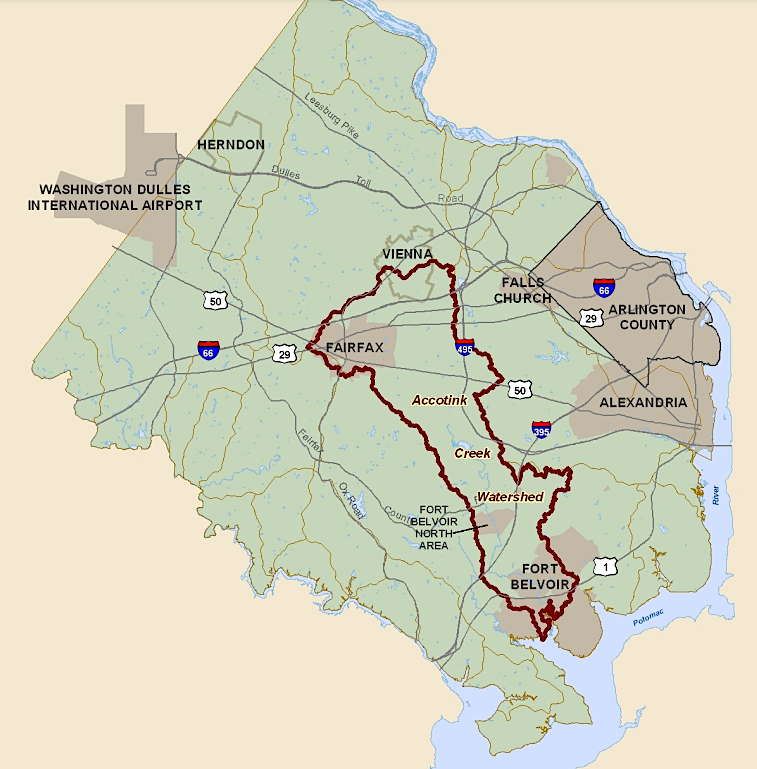
within the overall 52-square mile Accotink Creek watershed, 30 square miles drain into Lake Accotink
Source: Fairfax County, Accotink Creek Watershed Management Plan (Map 3-1)
Suburban housing developments built during the Cold War altered the 30-square mile watershed that drains into the lake. Today, 28% is impervious surface such as rooftops, roads, and paved driveways.
Despite the retention of a thin buffer of vegetation along Accotink Creek, a massive amount of sediment has washed downstream to the dam. The Virginia Department of Environmental Quality (DEQ) established stormwater management regulations in 1992, but even the 2014 revisions still allow for some sediment runoff from developed land and construction sites.
The Corps of Engineers dredged Lake Accotink before the 1967 land transfer, but by 1985 sediment accumulation had reduced the water storage capacity by 75%. Fairfax County dredged the lake in 1985 and again in 2008, creating an 8' deep lake. The Board of Supervisors approved another dredging in 2019 projected to cost $30 million. the Department of Public Works and Environmental Services was reluctant to establish a perpetual process of sediment removal.
As described by county staff:2
- It's kind of like digging a hole in the beach when the waves are coming in.
Staff later estimated that to achieve an 8' deep lake again, 500,000 cubic yards rather than 350,000 cubic yards would have to be excavated. Costs would increase to $95 million in part because Dominion Power was unwilling to authorize use of a nearby powerline easement to dry out the dredge spoils before they were trucked away. New infrastructure are Wakefield Park Maintenance Facility eliminated use of that posible location for drying the spoils.
A drying site within the park would require clearing seven acres of trees, and removal would require 50,000 trips by dump trucks (each carrying 10 tons of sediment) through nearby communities. Over the next 20 years, $300 million would be required to perpetuate a 55-acre Lake Accotink.
Staff considered letting the sediment accumulate and gradually convert the lake into a wetland, so Lake Accotink Park would end up similar to Huntley Meadows Park. During the public debate over costs and benefits, a leader in Save Accotink Lake accused county staff of being inflexible:3
- What is absolutely clear is that, in 2018, the only choice the county wanted was to let the lake fill in... In 2023, the only choice they want is to fill the lake in. There are no dots to connect there. It's the same dot.
What had been a 110-acre lake in 1918 was by 2023 just a 49-acre lake within the 476-acre county park. However, many of the 250,000 visitors a year were clearly fond of perpetuating Lake Accotink; it was one of the most visited sites in the county park system.
The 30-person Task Force on the Future of Lake Accotink suggested dredging again, but to maintain a smaller 20-40 acre Lake Accotink. To avoid the expense of trucking dredged material to a distant disposal site, dredge spoils could be used to create a wetland and grassland area within Lake Accotink Park.
Options explored were:
- Do nothing.
- Dredge on approximately 15-year intervals to maintain recreational opportunities of the lake.
- Construction of a sediment forebay (either just upstream or within the existing footprint of the lake).
- Installation of "beaver dam" structures in line with Accotink Creek upstream of the lake.
- Remove the existing dam and return Accotink Creek to a single thread channel within the current lake footprint.
- Remove a portion of the existing dam to create a smaller lake along with a single thread channel.
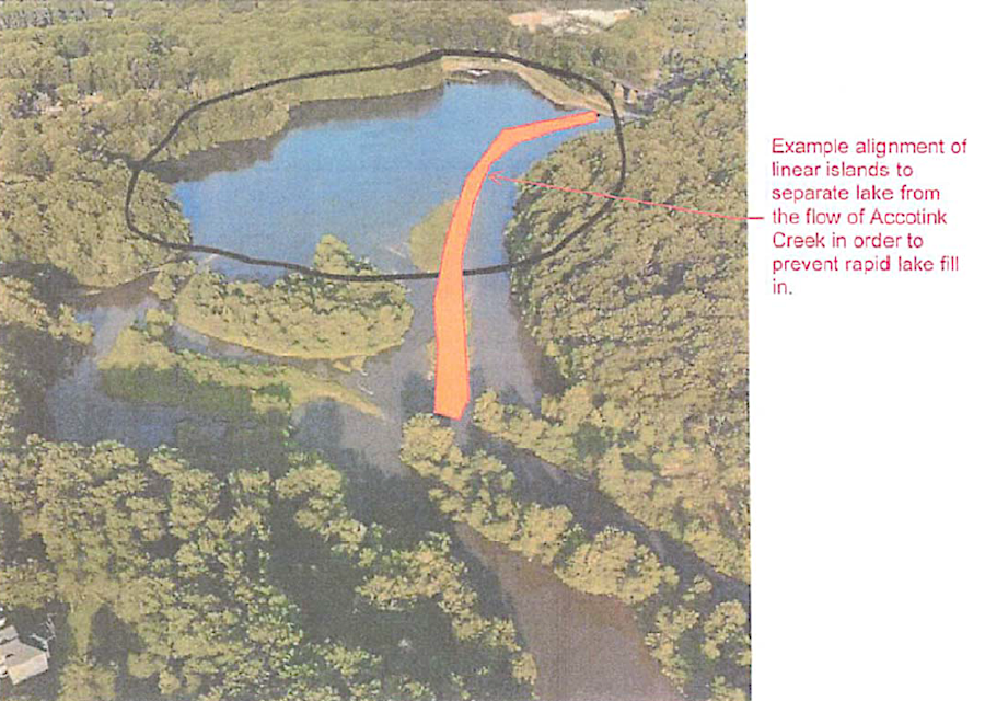
a barrier isolating Lake Accotink from the flow of the creek was one way to limit silt from being deposited into the lake
Source: Fairfax County, Lake Accotink Task Force Findings Report (Picture B.1)
Alternatives offered by the task force included:5
- A roughly 41-acre lake extending from the marina to the "big island" at the northern end of the lake. It would cost an estimated $34 million to dredge the approximately 9 million cubic feet of sediment required to maintain a depth of 8 feet
- A 22-acre lake that would require a dredge of about 3.9 million cubic feet, costing an estimated $24 million
- A 33-acre lake with a grassland built on sediment dredged from the lake and deposited in its footprint
The Fairfax County Board of Supervisors decided on January 23, 2024 to preserve a 20-40 acre Lake Accotink at a depth of four-eight feet. The county supervisors also committed $60 million for that effort, with $1.4 million for a study by the US Geological Survey to measure sediment flow. Braddock District Supervisor James Walkinshaw said:6
- ...this partnership with USGS will install gauges so we will actually know how much sediment is entering the lake and how much sediment is leaving the lake.
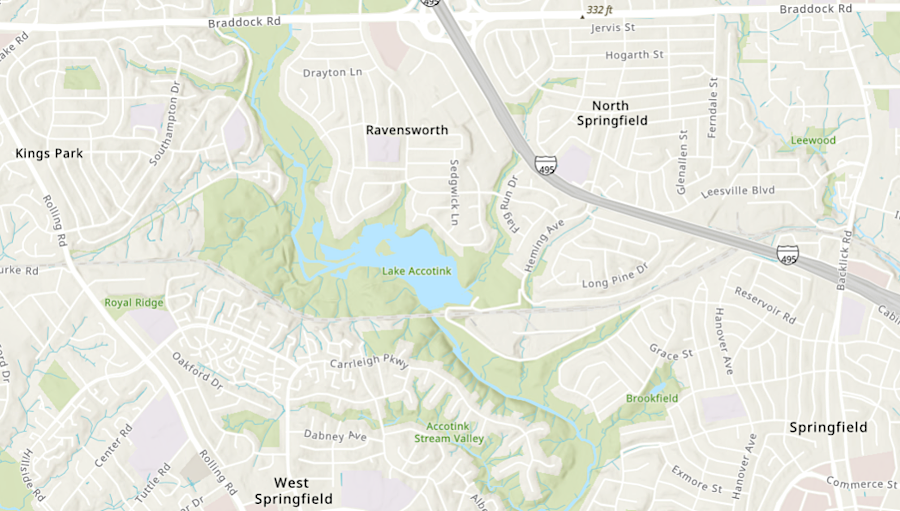
a thin buffer of vegetation separates Lake Accotink from suburban development
Source: ESRI, ArcGIS Online
Links
References
1. "A History of Lake Accotink - Part 1," Burke Historical Society, June 24, 2020, https://burkehistoricalsociety.org/a-history-of-lake-accotink-part-1/; "A History of Lake Accotink - Part 2," Burke Historical Society, August 4, 2020, https://burkehistoricalsociety.org/a-history-of-lake-accotink-part-2/; "History of Lake Accotink - Part Three," Burke Historical Society, August 26, 2020, https://burkehistoricalsociety.org/history-of-lake-accotink-part-three/ (last checked July 4, 2024)
2. "Lake Accotink Analysis and Feasibility Study," Fairfax County, https://www.fairfaxcounty.gov/publicworks/lake-accotink-dredging; "Officials ready to let urban runoff swallow a cherished Virginia lake," Washington Post, March 5, 2023, https://www.washingtonpost.com/dc-md-va/2023/03/05/lake-accotink-urban-runoff/; "Lake Accotink Task Force Report," December 4, 2023, p.4, https://www.fairfaxcounty.gov/topics/sites/topics/files/assets/latf%20draft%20findings%20report%2012-03-23.pdf (last checked July 4, 2024)
3. "Lake Accotink Analysis and Feasibility Study," Fairfax County, https://www.fairfaxcounty.gov/publicworks/lake-accotink-dredging; "Officials ready to let urban runoff swallow a cherished Virginia lake," Washington Post, March 5, 2023, https://www.washingtonpost.com/dc-md-va/2023/03/05/lake-accotink-urban-runoff/; "Fairfax County creates task force for future of troubled Lake Accotink," Washington Post, May 23, 2023, https://www.washingtonpost.com/dc-md-va/2023/05/23/lake-accotink-fairfax-county/; "Springfield's Lake Accotink shouldn't be dredged, but allowed to become a wetland, report says," FFX NOW, February 15, 2023, https://www.ffxnow.com/2023/02/15/springfields-lake-accotink-shouldnt-be-dredged-but-allowed-to-become-a-wetland-report-says/ (last checked July 4, 2024)
4. "Lake Accotink Task Force Findings Report," Fairfax County, Decemmber 4, 2023, https://www.fairfaxcounty.gov/topics/sites/topics/files/Assets/Findings%20Report%20for%20Lake%20Accotink%20Task%20Force%20final%20(v.2)%2020231208.pdf (last checked July 6, 2024)
5. "Lake Accotink Analysis and Feasibility Study," Fairfax County, https://www.fairfaxcounty.gov/publicworks/lake-accotink-dredging; "Fairfax County moves to create smaller version of imperiled Lake Accotink," Washington Post, January 23, 2024, https://www.washingtonpost.com/dc-md-va/2024/01/23/lake-accotink-dredging-sediment-plan/; "Lake Accotink task force finds lake could be partially saved with regular dredging," FFX Now, December 6, 2023, https://www.ffxnow.com/2023/12/06/lake-accotink-task-force-finds-lake-could-be-partially-saved-with-regular-dredging/ (last checked July 4, 2024)
6. "Clerk's Board Summary," Fairfax County, January 23, 2024, pp.25-28, https://www.fairfaxcounty.gov/boardofsupervisors/sites/boardofsupervisors/files/Assets/meeting-materials/2024/Jan23-Board-Summary.pdf; "Fairfax County partners with USGS for $1.14 million study to preserve Lake Accotink," FFXNow, July 22, 2024, https://www.ffxnow.com/2024/07/22/fairfax-county-partners-with-usgs-for-1-14-million-study-to-preserve-lake-accotink/ (last checked July 4, 2024)
Rivers and Watersheds of Virginia
Virginia Places


