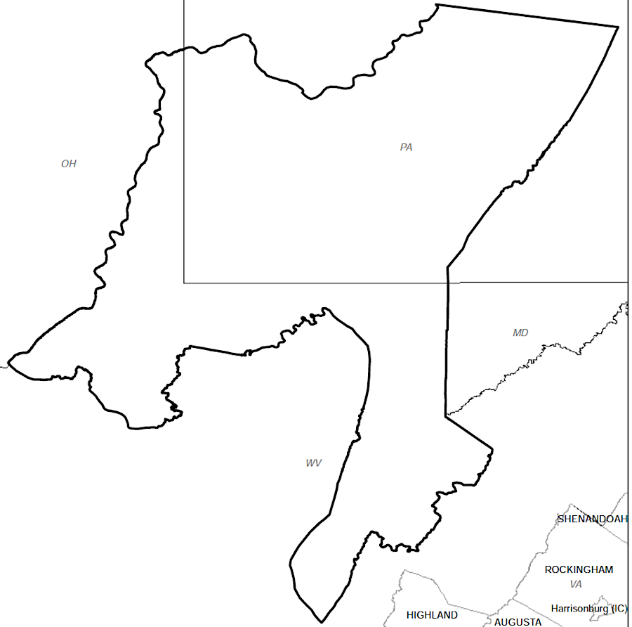
Virginia's District of West Augusta encroached into territory claimed by the colony of Pennsylvania
Source: Newberry Library, Atlas of Historical County Boundaries
Virginia's District of West Augusta encroached into territory claimed by the colony of Pennsylvania
Source: Newberry Library, Atlas of Historical County Boundaries
Virginia and Pennsylvania disputed the rights to the Forks of the Ohio, where the French built Fort Duquesne in 1753. The Virginia response, an expedition to expel the French led by a 22-year old George Washington, triggered the French and Indian War. By 1763 the French had ceded their claims to Canada and the lands west to the Mississippi River, and the English had replaced Fort Duquesne with Fort Pitt.
Shareholders in the Ohio Company, who anticipated gaining wealth by selling tracts of western land, were frustrated by the issuance of the Proclamation of 1763. It banned settlement west of the Eastern Continental Divide. After the start of Pontiac's War in 1763, officials in London sought to limit westward expansion of the colonies. The Proclamation of 1753 blocked settlement, or at least acquisition of clear title to land, west of the Appalachians. Minimizing settlement was expected to minimize conflict with the Native Americans, and thus minimize the costs of stationing British Regulars in the colonies.
British policy was inconsistent and controls on western traders were minimal, so peace with the Native Americans remained tenuous. Land speculation by colonial leaders and their cohorts in London was intense. Different companies jockeyed for political favors, while veterans of the French and Indian War struggled to acquire title to acres awarded for their military service. few final patents to officially transfer land To reduce the costs of maintaining military forces in the western lands, in 1772 the British abandoned Fort Pitt and destroyed its fortifications.
Most officials in the colonies, other than the royal governors and top military leaders, supported western expansion. Imperial policy set in London interfered with the most obvious way to acquire wealth in North America - acquire land cheap, wait for settlers to arrive, then and sell land at high prices.
Royal agents, including the Superintendent of Indian Affairs for the Northern Department and his deputy, spent much of their time negotiating cessions by Native American tribes of land west of the Allegheny Mountains. Various treaties reflected the presumption that the barrier to settlement established by the Proclamation of 1763 was just a temporary measure. In the 1768 Treaty of Fort Stanwix, the Iroquois (speaking also for the Shawnee, Delaware, Mingo, and other supposedly-dependent tribes) ceded lands south of the Ohio River.
Though that treaty was ultimately approved in London, land sales to settlers remained blocked by the Proclamation of 1763. Numerous colonial officials were personally involved with different land companies that sought to get royal approval of massive land grants that would allow for settling acres to which the Iroquois and Cherokee had relinquished their claims south of the Ohio River, plus lands north of that river. Public and private interests were mixed in London as well, as the land companies arranged for the king's appointees to get rewarded if grants were approved.
The arrival of unauthorized settlers caused Pennsylvania to asserted its claim to Fort Pitt and other land on the western edge of the colony, citing boundaries defined in the grant to William Penn in 1682. At the start of 1773, the Ohio Company sent a task force to build a new fort to replace Fort Pitt. The Pennsylvania colony responded by establishing Westmoreland County on February 26, 1773. The county court was located at Hanna's Town, which is near modern-day Greensburg east of Pittsburgh.1
For several years, Virginia and Pennsylvania officials arrested and imprisoned each other near Pittsburgh. They organized mobs/militia as they claimed exclusive authority to grant land and manage trade with Native Americans along the Ohio River.
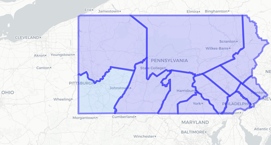
Pennsylvania established Westmoreland County in April, 1773, asserting its claim to the Forks of the Ohio
Source: Newberry Library, Atlas of Historical County Boundaries
Governor Dunmore personally visited Fort Pitt in the summer of 1773. He had planned to travel there with George Washington, who was lobbying for the right to William Bullitt and others to complete surveys so French and Indian War veterans could claim the land bounties promised for enlisting and serving in that war. Washington was also involved with the Ohio Company, which was struggling to obtain authorization to survey and sell lands based on a 1748 grant before squatters occupied the high-value bottomlands along the river valleys.
Washington dropped out of the trip after his step-daughter died, missing a chance to deepen his personal connections with Dunmore and obtain special favors. The governor did not cancel; he proceeded to ride from Williamsburg to the Ohio River.
At Fort Pitt, Dunmore met Dr. John Connolly and hired him as his agent. In October, the governor ignored his royal instructions and granted Connolly 2,000 acres downstream at the Falls of the Ohio. Dunmore had been a land speculator seeking to use his powers to obtain personal wealth when governor of New York, and he followed the same pattern in his Virginia role. Had Washington been able to make the trip, he too might have received special consideration from the governor.
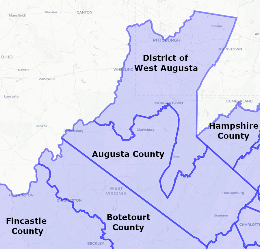
Dunmore recognized the value of the lands along the Ohio River and to the west, and the potential that he would lose a major opportunity if Pennsylvania officials approved surveys and issued patents. The Virginia General Assembly responded to the creation of Westmoreland County by establishing the District of West Augusta on October 10, 1773. It was called a "district" rather than a "county." Exact boundaries were unclear during the three years in which the district existed.
"District" was used because King George III had sent instructions to Governor Dunmore to block the creation of new counties that would add new members to the House of Burgesses. Thomas Jefferson complained in "A Summary View of the Rights of British America:"3
Virginia created the District of West Augusta on October 11, 1773
Source: Newberry Library, Atlas of Historical County Boundaries
The Third Virginia Convention in July, 1775, created a Committee of Safety and organized 16 military districts. The convention received a "letter from the committee on the Western Waters of Augusta, enclosing several papers on the subject of Indian affairs." Treaty negotiations with the Shawnee were still underway, after the Virginia colonists had won Dunmore's War in 1774, and the security of the western frontier was as tenuous as the security of Tidewater.
The convention tasked the District of West Augusta to raise three companies of riflemen for the colony's new army. Virginia could no longer rely upon the British Army to provide support if the Shawnee renewed attacks. One company was assigned to the First Virginia Regiment in Tidewater, led by then-Colonel Patrick Henry. Two companies were assigned for western frontier defense:4
The Fifth Virginia Convention declared independence in May, 1776. There was no longer any reason to be concerned about a violation of the Proclamation of 1763.
On October 7, 1776, the new General Assembly dissolved the District of West Augusta and replaced it with three official counties - Monongalia, Ohio and Yohogania.5
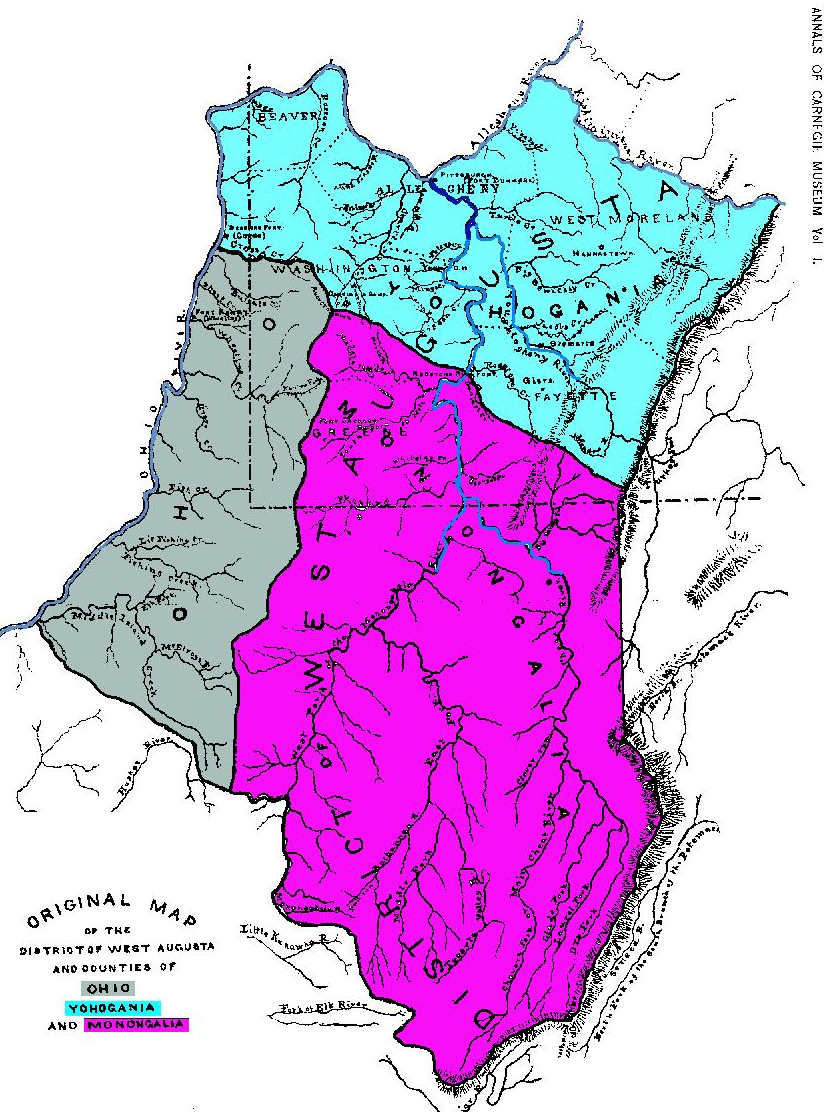
the District of West Augusta was replaced by Ohio and Monongalia counties (now part of West Virginia) and Yohogania County (extinct)
Source: Wikipedia, Yohogania County, Virginia