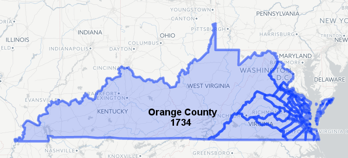
in 1734, Kentucky and the rest of Virginia's western land claims were included within the boundaries of Orange County
Source: Newberry Library, Atlas of Historical County Boundaries
in 1734, Kentucky and the rest of Virginia's western land claims were included within the boundaries of Orange County
Source: Newberry Library, Atlas of Historical County Boundaries
As European settlers migrated west, the Virginia General Assembly created new counties with local courthouses where surveys and land deeds were recorded, and where local judges resolved disputes. Virginia's General Assembly created the county of Kentucky in 1776. It was later divided into multiple counties as population grew, and in 1792 all were incorporated in the new state of Kentucky.
The land called Kentucky had been occupied by humans for 15,000 years. Virginia's claim to the land was based on a document signed in England, the Second Charter issued to the Virginia Company by James II in 1609. That charter granted to the colony of Virginia a swath of land extending from sea to sea, west and northwest. It ignored the pre-existing claims of the current residents on the land, descendants of the original migrants who had arrived at the end of the Ice Age.
The Native American cultures encountered by the colonists in the 1700's were very different from the original Paleo-Indian culture. By the time Virginia colonists began to carve out farms west of the Blue Ridge, Cherokee and Shawnee tribes were the primary occupants of the Appalachian Plateau. The Iroquois also traveled south through the region. They came from what the English called New York, typically on long hunting expeditions and on raids against the Cherokee and other Native American groups.
The colonists could not resolve the competing claims to Kentucky, so they negotiated for its acquisition from the Shawnee, Cherokee, and Iroquois.
In negotiations to redefine the western edge of legitimate colonial settlement after King George III issued the Proclamation of 1763, the Iroquois sought compensation before relinquishing their rights to the land south of the Ohio River and west to the Tennessee River. That Iroquois claim was based on the right of conquest over the Shawnee. Though that claim was highly questionable, the British paid the Iroquois to extinguish whatever rights the Iroquois possessed in the 1768 Treaty of Fort Stanwix.
Separate negotiations with the Cherokee resulted in the 1768 Treaty of Hard Labor and the 1770 Treaty of Lochaber. The Cherokee surrendered their claims to lands east of the Appalachian Front. In neither treaty did the Cherokee formally cede their claims to Kentucky, though an informal arrangement in 1770 allowed colonial settlement east of the Kentucky River.
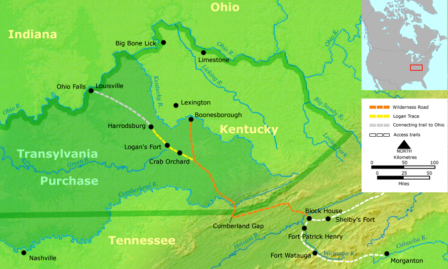
In the 1775 Treaty of Sycamore Shoals/Treaty of Watauga, Richard Henderson and the Transylvania Company ignored both royal policy and colonial government authority. Henderson purchased 20 million acres from the Cherokee, plus a Path Deed to access the Transylvania Purchase, and hired Daniel Boone to build a road through Cumberland Gap.
When the Cherokee relinquished their claim to Kentucky in the 1775 Treaty of Sycamore Shoals, Dragging Canoe refused to endorse the sale. He warned Richard Henderson and his Transylvania Company that they were purchasing a "dark and bloody ground," with Shawnee and Cherokee conflicts still remaining over ownership.
in the 1775 Treaty of Sycamore Shoals, the Transylvania Company bought 20 million acres north of the Cumberland River from the Cherokee, who had thin claims to ownership
Source: Wikipedia, Sycamore Shoals
Colonial exploration into far western Virginia was triggered by land speculators. They obtained large land grants from the king, then sought to survey and sell parcels to the growing population in the colonies. The gentry of Virginia and Pennsylvania coerced their colonial governments and Native Americans into making land speculation "legal," then sponsored expeditions to explore, hype, and sell western lands.
Settlers migrated first from Pennsylvania into the Shenandoah River Valley, then others kept walking south to occupy the Holston River valley and other tributaries of the Tennessee River. In 1734, the General Assembly of Virginia created Orange County, the first local government with boundaries that extended west of the Blue Ridge.
That county was subdivided in 1738, and its land west of the Blue Ridge was incorporated into Augusta and Frederick counties. Enough settlers arrived finally to start actual county court operations in Frederick County in 1743, and in Augusta County in 1745. The undefined western border of Augusta County was not a problem. There were few long hunters and fur traders west of the Allegheny Front, and they required minimal support for documenting land claims or resolving disputes in court.
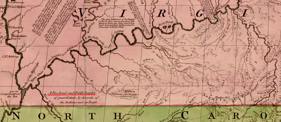
John Mitchell's 1755 map of the Kentucky territory described that portion of Augusta County (at the time) as a "Fine Level and Fertile Country"
Source: Library of Congress, A map of the British and French dominions in North America (by John Mitchell, 1755)
In 1749, the Loyal Land Company obtained a grant from the Governor's Council to 800,000 acres on the Appalachian Plateau, including much of what would become Kentucky. That land speculation syndicate was composed of members of the gentry who enough substantial clout in Williamsburg to get the governor's authorization for "free land." The Greenbrier Company had set the example in 1745, when it obtained a grant for 100,000 acres in the Greebrier Valley of modern-day West Virginia.
The Ohio Company also obtained a different land grant in 1749. The Ohio Company authorization was for 500,000 acres, with 300,000 acres contingent upon settling 100 families within seven years). The Ohio Company grant was for lands near the forks of the Ohio River, further north from the lands desired by the Loyal Land Company. The leaders of the Loyal Land Company were concentrated in the Piedmont, while the gentry in the Ohio Company were largely from the Northern Neck.
The first colonial explorers into the Appalachian Plateau left little indication of their presence. The first documentation of a crossing through the Cumberland Gap was the 1750 journal of Dr. Thomas Walker, a key member of the Loyal Land Company.
Walker was exploring across the mountains to determine what areas to advertise, survey and sell. The grant to the Loyal Land Company came at no cost, but required lands to be surveyed within four years. The syndicate would gain revenue only if settlers purchased individual parcels. Walker also was identifying possible routes that would be used to cross the mountains, which is why he examined Cumberland Gap.
The Ohio Company efforts to build a fort at the headwaters of the Ohio River were blocked when French troops moved into the area, seized the "Forks of the Ohio," and constructed Fort Duquesne (later the site of Pittsburgh). The Virginia response led by George Washington triggered the French and Indian War. Tense fighting with Native American tribes during that war delayed colonial efforts to occupy lands west of the Atlantic Ocean-Gulf of Mexico watershed divide.
Augusta's western edge theoretically extended to the Pacific Ocean until the end of the Seven Years War/French and Indian War. The 1763 Treaty of Paris defined the Mississippi River to be far western edge of Virginia. The colony no longer stretched from "from sea to sea" because after 1763 the English accepted Spain's claim to lands on the west side of the Mississippi River.
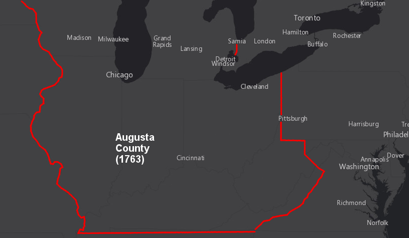
Augusta County extended to the Mississippi River at the end of the French and Indian War in 1763
Source: ESRI, ArcGIS Online
Between 1745-1770, Augusta County included all the land claimed by Virginia that was west of the Blue Ridge. The eastern edge of Augusta County extended along the crest of the Blue Ridge, south of the Fairfax Grant line, to the North Carolina border. The western boundary extended all the way west to the Pacific Ocean until 1763, when the Treaty of Paris ending the French and Indian War established the Mississippi River as the edge.
The prohibitions in the Proclamation of 1763 deterred the General Assembly from creating new counties west of the Eastern Continental Divide, but the ban on settling the area was overcome by negotiating the 1768 Treaty of Hard Labor, 1768 Treaty of Fort Stanwix, 1770 Treaty of Lochaber, and 1774 Treaty of Camp Charlotte.
By 1770, enough people had followed the paths south of the Shenandoah Valley to justify creating a new local government. Augusta County was split, and the future state of Kentucky became the southwestern part of Botetourt County. Population growth continued in the southwest, and in 1772 Fincastle County was carved out of Botetourt County.
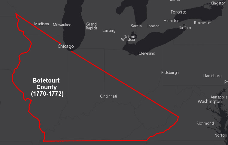
Kentucky was part of Botetourt County between 1770-1772
Source: ESRI, ArcGIS Online
The new Fincastle County was huge. Boundaries were defined by a line that ran from the Ohio River up the New River to "Culbertson's creek" (perhaps the mouth of the Greenbrier River in West Virginia), then east across Giles County to roughly I-81 (near Exit 118 to Virginia Tech), then west of Radford though Floyd County to the crest of the Blue Ridge, on south to the North Carolina border, and then west to the Mississippi River.1
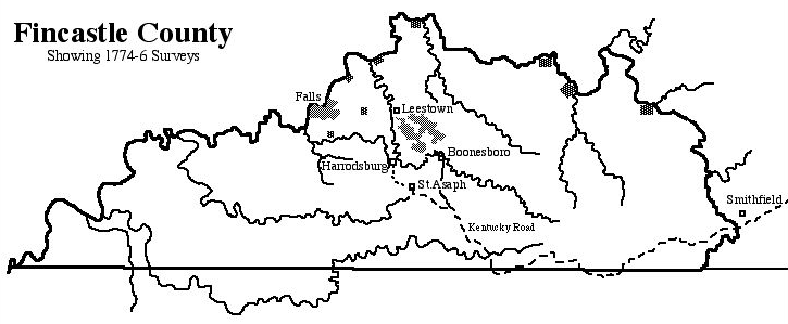
Kentucky was part of Fincastle County between 1772-1777
Source: Kentucky Secretary of State, Geographic Materials
British leaders struggling to pay for the recent war thought it was time to rein in the Virginia settlers and minimize the costs of protecting colonists in the backcountry. Officials in London determined that English settlement should be restricted to the Atlantic Ocean watersheds, while an Indian Reserve should be established west of the colonists. King George III issued the Proclamation of 1763, banning settlement west of the Appalachians in order to mininmize conflicts in the borderlands.
This ban, and the concurrent opening of West Florida (the Natchez territory in Mississippi) to settlement, was expected to minimize disputes over territory with the Iroquois, Shawnee, Cherokee, and other tribes. Fewer disputes would, at least in theory, minimize the military costs for protecting English settlements.
There was a different perspective in Williamsburg. Lord Dunmore, though the royal governor of Virginia, was more than willing to ignore the restrictions in the Proclamation of 1763, the 1768 treaties of Fort Stanwix and Hard Labor, and even the 1774 transfer of Virginia's western lands to the province of Quebec.
In 1773, Dunmore overruled objections from Fincastle County officials and approved private surveys for land claims at the obviously-valuable but far-away Falls of the Ohio River (now Louisville). He also declared that military warrants, which entitled officers and soldiers who fought in the French and Indian War to land grants, could be filed anywhere in Virginia.
In addition to helping make Kentucky more attractive by facilitating land claims, Dunmore initiated a war with the Shawnee. Lord Dunmore's War culminated in the Shawnee defeat at the Battle of Point Pleasant, and the Treaty of Camp Charlotte forced the Shawnee to cede their claims to territory south of the Ohio River. A year later when Cherokee signed the Treaty of Sycamore Shoals to cede their claim to the area, Dragging Canoe described the territory as a "dark and bloody ground" due to the hostilities based on overlapping claims.2
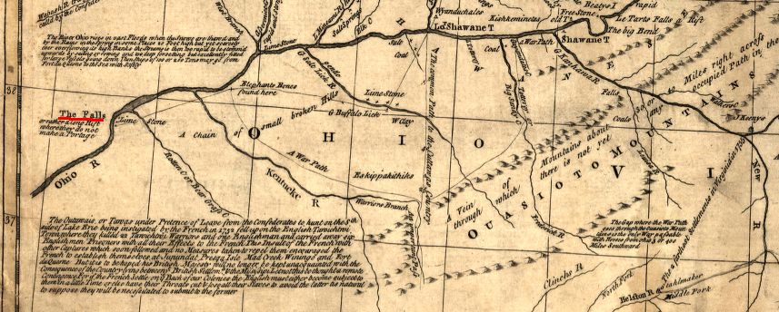
Falls of the Ohio
Source: Library of Congress, A general map of the middle British colonies in America by Lewis Evans, 1771
In 1775, Lord Dunmore was forced out of office. He fled Williamsburg as the colony joined what became the American Revolution. Virginia officials faced the same choices as the British officials: how much should be invested in protecting the scattered settlements on the edge of settlement?
The rebel leaders in Williamsburg were reluctant to supply arms and ammunition to the frontier settlers west of Cumberland Gap. When George Rogers Clark arrived in Williamsburg and requested supplies, his request was initially rejected. Governor Patrick Henry provided the requested lead and powder only after Clark wrote to Virginia officials suggesting the Kentucky residents might negotiate a deal with the Spanish or French if the Virginians were unwilling to provide aid:3
In 1776, the General Assembly of the new Commonwealth of Virginia created Kentucky County.
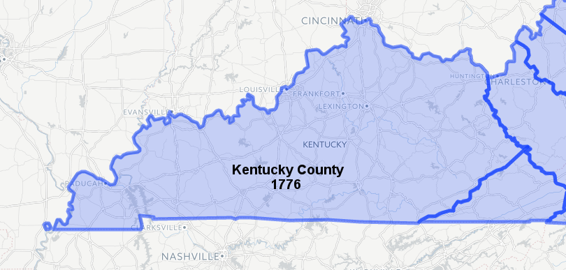
in 1776, Virginia was an independent state and the Proclamation of 1763 no longer deterred creation of new western counties
Source: Newberry Library, Atlas of Historical County Boundaries
In 1780, the state divided Kentucky County into three smaller counties - Fayette, Jefferson, and Lincoln.
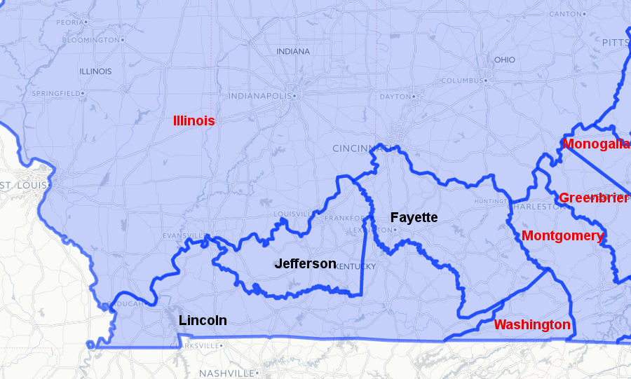
Kentucky County, created in 1776, was replaced in 1780 by Fayette, Jefferson, and Lincoln counties
Source: Newberry Library, Atlas of Historical County Boundaries