the tip of Buchanan County marks the Kentucky-Virginia-West Virginia border
Source: US Geological Survey (USGS), Wharncliffe, WV-VA-KY 7.5-minute topographical quadrangle map (2014)
the tip of Buchanan County marks the Kentucky-Virginia-West Virginia border
Source: US Geological Survey (USGS), Wharncliffe, WV-VA-KY 7.5-minute topographical quadrangle map (2014)
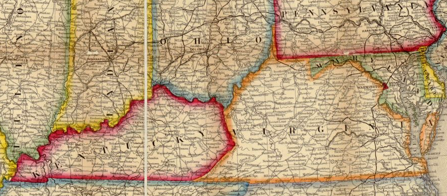
Creating the current Virginia-Kentucky state boundary involved less conflict and less debate than creating the boundaries that now exist between Virginia and North Carolina, Tennessee, Maryland, and the District of Columbia.
In 1776, the General Assembly divided Fincastle County to create Washington, Montgomery, and Kentucky counties. The name Fincastle disappeared, since it honored the family of Lord Dunmore at a time when he had fled from the developing American Revolution in Williamsburg.
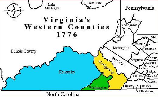
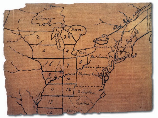
a Virginia county was first called Kentucky in 1776, when Fincastle County was split into three jurisdictions
Source: Kentucky Secretary of State, Geographic Materials
The straight line of the Virginia-North Carolina boundary and the twisted boundaries of two natural features - the Big Sandy River and the Cumberland Mountains - were used to define the edges of the new county called Kentucky:1
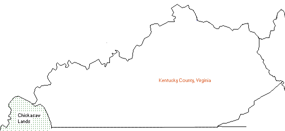
Kentucky County was created in 1776
Source: Kentucky Secretary of State - Geographic Materials, Animated County Maps 1776-1795
In 1780, Kentucky County was subdivided into Jefferson, Lincoln, and Fayette counties.
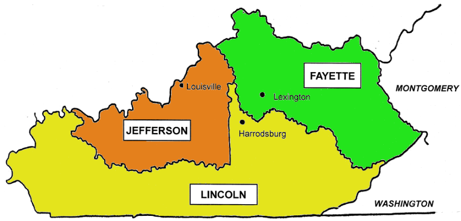
by 1780, Kentucky County had been split into Jefferson, Lincoln, and Fayette counties
Source: Kentucky Secretary of State - Geographic Materials, 13 Colonies
Being west of the Allegheny Front was key to the development of Kentucky. Settlers crossed through Cumberland Gap to obtain cheap land, and that land was used for farming. Surplus agricultural products, including deerskins, lumber, and corn converted into whiskey, were floated down the Sandy, Kentucky, and Cumberland rivers to Ohio River and then down the Mississippi River to market at New Orleans.
George Washington feared that the United States would lose support of western settlers unless new transportation infrastructure could bring their products across the mountains to port cities on the Atlantic seaboard. Washington personally supported a canal to facilitate the connection between west and east via the Potomac River, but Virginia's leaders living east of the Appalachians remained focused on trade via rivers that flowed eastward to the Chesapeake Bay.
The General Assembly made few investments in the Kentucky country. The legislature was unresponsive to requests to fund roads and canals west of the Allegheny Front that would send agricultural goods down the Mississippi River, rather than to a port in Virginia.
Topography made it difficult to get Kentucky's products to the Chesapeake Bay. A road or canal from the Cumberland Gap to a Virginia port was clearly not feasible in the 1700's. The costs to carry heavy freight by horse-drawn wagon for 350-400 miles to Richmond, including a crossing of the Blue Ridge, were too high for farmers to make a profit. The only feasible option was to float freight down the rivers, and in Kentucky the rivers float west to the Mississippi River.
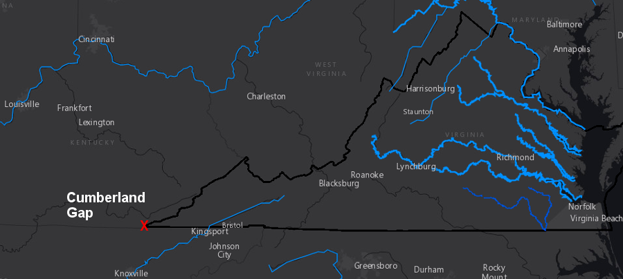
in the late 1700's, there was no realistic way to construct a canal or road to carry Kentucky's agricultural products through Cumberland Gap to a port on the Atlantic seaboard
Source: ESRI, ArcGIS Online
Virginia chose to give away its lands north of the Ohio River, ceding the Northwest Territory to the new Continental Congress. Retaining Virginia's claim to the far western lands would have required funding for defense against Native Americans and the British in Canada, and for transportation projects that would not bring trade to Alexandria, Fredericksburg, Richmond, or Petersburg.
Without support for roads or defense from the Virginia legislature in Richmond, settlers in Kentucky County saw that remaining within Virginia would provide few benefits. They would pay taxes to a General Assembly on the other side of the Cumberland Mountains, to a legislature that would not support trade to New Orleans and might not respond to raids from Shawnee living north of the Ohio River.
Kentuckians concluded that it made more sense to convert their region into an independent state. There was even a possibility it could become part of a new colony/state of Transylvania, proposed by land speculator Richard Henderson when he purchased land rights from the Cherokees in the 1775 Treaty of Sycamore Shoals.
There were 10 conventions in Kentucky between 1784-1792 that debated the details and future organization of government. In 1792, the US Congress made Kentucky the second new state to enter the Federal union. Kentucky was a state that supported slavery, and its admission balanced the addition of Vermont in the north.2
after creation of Kentucky, lands north and east of the Big Sandy River and its Tug Fork tributary were still Virginia - until West Virginia was created in 1863
Source: Library of Congress, A new map of the United States. Upon which are delineated its vast works of internal communication, routes across the continent &c. showing also Canada and the Island of Cuba
As part of the deal to support the creation of a new Commonwealth of Kentucky, Virginia reserved lands between the Green and Cumberland rivers for honoring warrants for military service in the French and Indian War. That reservation was in addition to the Virginia Military Reserve north of the Ohio River in the Northwest Territory.
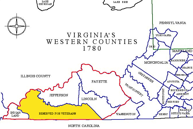
Virginia awarded land bounties to recruit soldiers, and reserved land within Kentucky as well as Ohio for land claims of veterans
Source: Kentucky Secretary of State, Neal Hammon Series of Maps - Virginia's Western Counties, 1780
In 1792, Virginia supported Kentucky's entrance into the Federal union as an independent state, with exterior boundaries unchanged since Kentucky County was formed in 1772. Most of the southern boundary between Virginia and the Southwest Territory (created in 1790) became a Kentucky-Southwest Territory boundary. Only the eastern portion of that line remained a Virginia-Southwest Territory boundary. That lasted until Tennessee was admitted to the Union in 1796.
Before agreeing to the establishment of Kentucky as a new state, Virginia had used its claims to the Northwest Territory as a bargaining chip to ensure the state retained control over the Kentucky district.
Virginia officials were concerned that the new national government might declare pre-existing claims void and force people with Virginia-authorized land claims to repurchase their land, since the traditional Virginia pattern of transferring land to private ownership was inefficient and created excessive legal confusion. The promise of a future voluntary cession of lands north of the Ohio River, and awareness that Virginia was willing to shrink and allow Kentucky to become a new state, kept the Continental Congress from interfering with Virginia's management of land south of the Ohio River.
In the cession of the Northwest Territory, Virginia carefully defined its boundary to be the low water mark on the northern shore of the Ohio River - not the middle of the river. That left Virginia in control of traffic on the entire Ohio River, just as Maryland had established title to the entire Potomac River based on its 1632 charter. When Kentucky became an independent state in 1792, it inherited control to the low water mark on the northern shore of the Ohio River.
The General Assembly also determined in the legislation authorizing Kentucky independence that:3
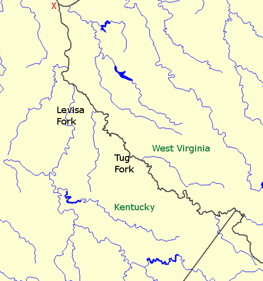
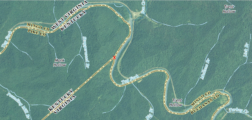
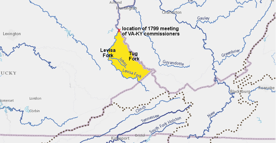
the "main or north easterly branch thereof" is the Tug Fork, not the Levisa Fork (the two merge to form the Big Sandy River, flowing north into the Ohio River at the red X on map)
Source: USGS, National Atlas
Unlike the Ohio River, Kentucky's boundary was in the middle and not on the western edge of the Mississippi River. The Mississippi River boundary had been determined in the 1783 Treaty of Versailles ending the American Revolution. Spain and England signed it in 1783, making a separate deal from the Treaty of Paris signed between England and the United States.
England agreed in the Treaty of Paris that American boats had the right to travel on the Mississippi River, but signed an inconsistent agreement with Spain. Under the 1783 Treaty of Versailles, Spain controlled the Louisiana Territory and still claimed exclusive right to navigation on the Mississippi River. Spain refused to let Americans float goods down the Mississippi River and export them through New Orleans after 1784, and the issue remained a flash point in Kentucky's dealings with the Federal government.4
Thomas Jefferson suggested that the boundaries of Kentucky should be part of his plan for creating new states out of western lands, starting at the mouth of the Kanawha River. Virginia was the largest state, both in population and acreage, in the new Federal government. Even after the separation of Kentucky, he felt that Virginia would be too large and unable to govern effectively all the territory that it would retain.

all of Kentucky was once a county in Virginia
Source: National Oceanic and Atmospheric Administration (NOAA), National Geophysical Data Center (NGDC)
Jefferson believed that democratically-elected leaders could not effectively manage large geographic areas, that governments dominated by business interests along the Atlantic seaboard would not be sensitive to concerns of farmers located west of the Alleghenies, and that governments would be more representative of the voters' interests if the Northwest Territory was subdivided into small states. His proposal for Kentucky's boundaries was intended less to benefit the new state and more to improve government in Virginia's remaining western lands.5
Thomas Jefferson proposed shrinking the size of Virginia, dividing Kentucky in half, and creating many small states out of the western lands acquired in 1783
Source: Manifest Destiny - Shaping America's Culture and Borders
To mark the boundary in 1799, Kentucky and Virginia followed the time-honored process used for defining Virginia's boundaries: each state appointed commissioners and surveyors. At the time, all the land on the northeastern side of the Big Sandy/Tug Fork rivers was still Virginia; West Virginia was not created until 1863.
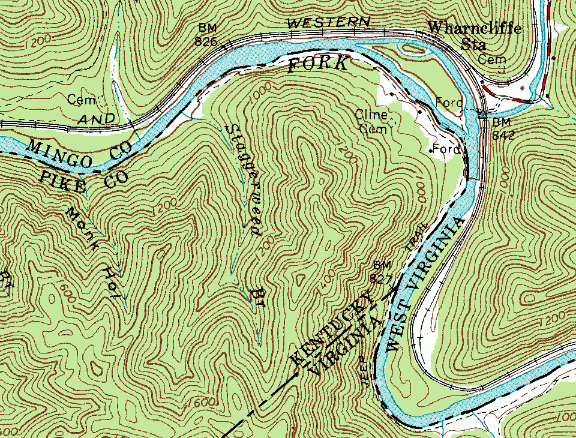
northern tip of VA-KY survey line (note that Virginia retained rights to the far shore of the Tug Fork, and West Virginia inherited those rights to the entire river)
Source: USGS, Digital Raster Graphic (DRG) of Wharncliffe 7.5 minute topo quad, downloaded from GIS Spatial Data Server at Radford University
The surveyors were directed to define a boundary as follows:6
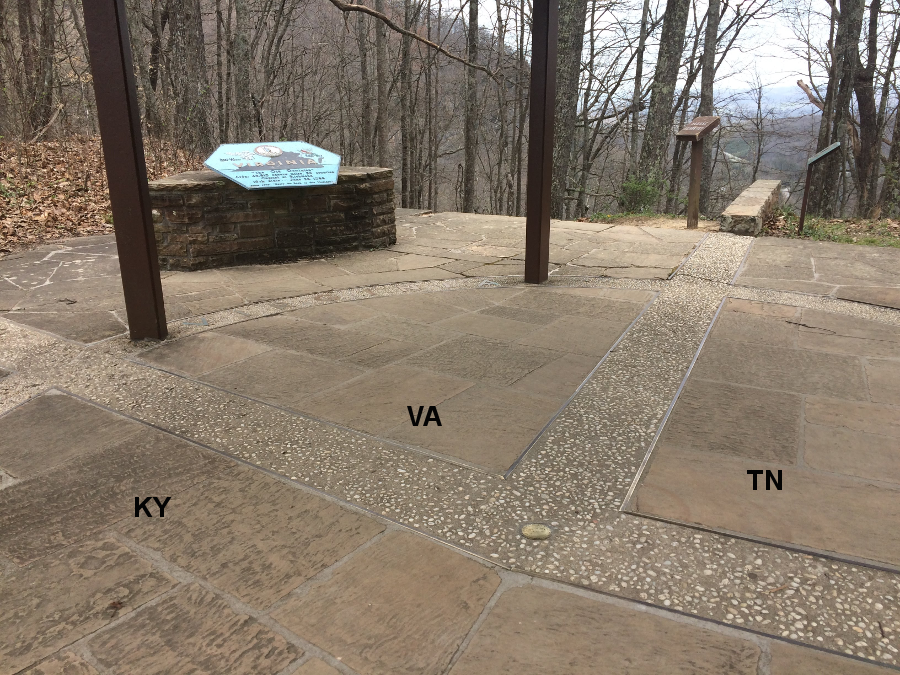
the southwest corner of Virginia meets Kentucky and Tennessee at Cumberland Gap
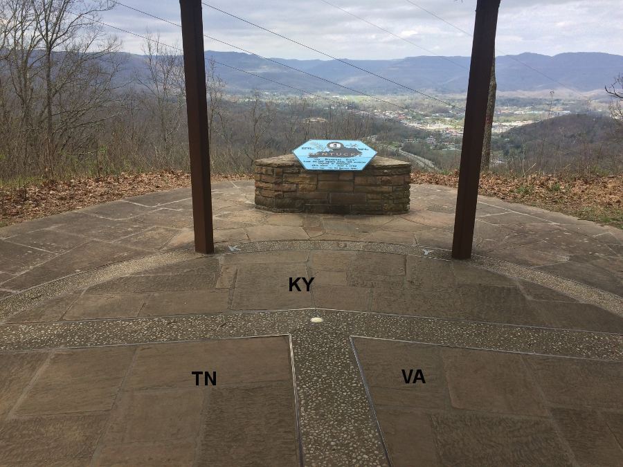
looking west towards Middlesboro, Kentucky from the tri-state boundary at Cumberland Gap
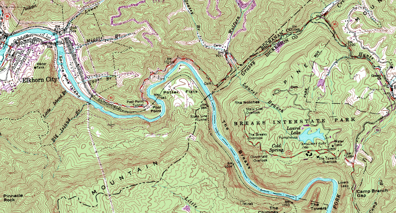
Though the description started at what today is the Tri-State Peak at Cumberland Gap, the surveyors started far to the northwest. They assembled in Kentucky, then walked up the Russell Fork of the Big Sandy River, a tributary of Levisa Fork, which is a tributary of the Big Sandy River. At the current location of Breaks Interstate Park, the commissioners and surveyors traced the mountain ridge northeastward.
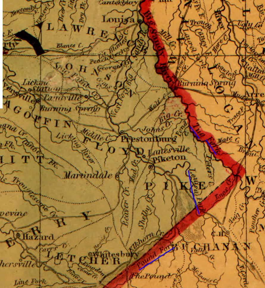
the Pound Fork flows into the Russell Fork before flowing across the Kentucky-Virginia border like the Levisa (Louisa) Fork, while the Tug Fork defines the Kentucky-West Virginia and Kentucky-Virginia borders
Source: Library of Congress, Colton's map of the southern states (1861)
They defined a line going 45° northeast line to the Tug Fork, another tributary of the Big Sandy River. That avoided zig-zagging across the rugged landscape to define the watershed divide on the crest of Cumberland Mountain, which defined the state boundaries south to the Walker Line at a point with "seven pines and two black oaks." The 1799 survey fixed only about 20% of the total state boundary.7
at the Russell Fork, the VA-KY line stops tracing the watershed boundary and becomes a straight line to Tug Fork
Source: USGS, Digital Raster Graphic (DRG) of Elkhorn City KY-VA 7.5 minute topo quad,
downloaded from Kentucky Geological Survey
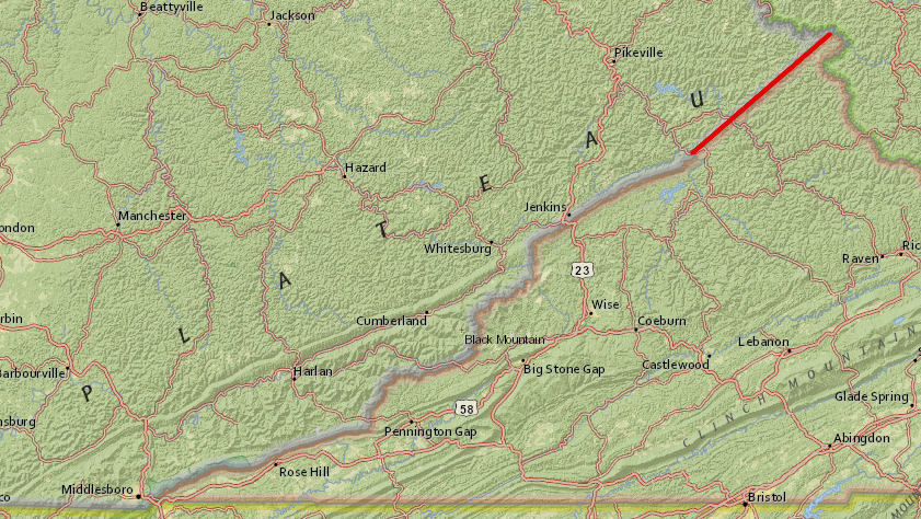
only a portion of the Virginia-Kentucky border (red line) has been surveyed
Source: ESRI, ArcGIS Online
In 1776, the Virginia General Assembly had defined the "main or north easterly branch" of the Tug Fork as the Kentucky County line. When it came time to determine which stream qualified as the "main or north easterly branch" to serve as the boundary between the states of Kentucky and Virginia, the 1799 surveyors and their commissioners made a judgment call.
According to one report, the commissioners and surveyors met at the confluence of the Tug and Levisa forks of the Big Sandy River on October 13, 1799. The starting point of the Big Sandy River, the confluence of the Levisa Fork and Tug Fork, is now the location of Louisa (Kentucky) and Fort Gay (West Virginia).
Discussions that evening were mellowed by strong drink, during which the commissioners agreed that the Tug Fork was the larger tributary and thus the main branch. The officials of each state planned to sign documents to that effect the next morning.
That night a major rainstorm caused the Levisa Fork to rise, and in the morning it rather than the Tug Fork appeared to be "main or north easterly branch." Despite the physical change, on October 14 the "true Kentuckians and Virginians agreed to ratify while sober, what they had agreed while drunk" and the Tug Fork was defined as the boundary line.8
the yellow on the map shows how much of Kentucky would have been placed in Virginia (now West Virginia) if the Levisa Fork had been chosen as the "main or north easterly branch" of the Big Sandy River
Source: ESRI, ArcGIS Online
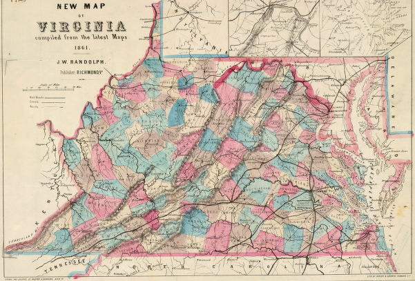
shape of Virginia after 1790 (when Kentucky became an independent state) until 1863 (when West Virginia was created)
Source: Library of Congress, New map of Virginia (1861)
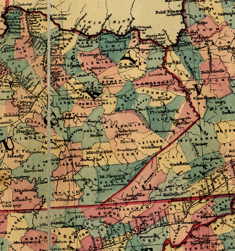
after the Civil War, Virginia added Dickinson County on its side of the Virginia-Kentucky border (as defined by the Cumberland Mountains)
Source: Library of Congress, Lloyd's map of the southern states showing all the railroads, their stations & distances, also the counties, towns, villages, harbors, rivers, and forts
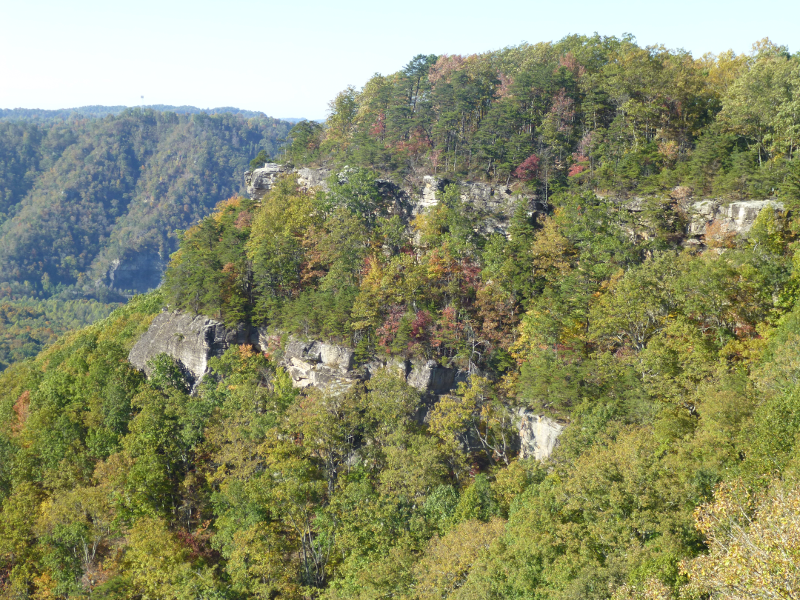
the Russell Fork cuts through Pine Mountain at Breaks Interstate Park, at the southern end of the surveyed boundary between Kentucky and Virginia