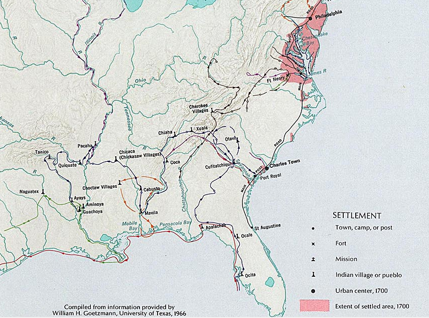
Spanish explorers reached the Piedmont and Blue Ridge over six decades before Jamestown was settled
Source: National Atlas, Exploration and Settlement (before 1675)
Spanish explorers reached the Piedmont and Blue Ridge over six decades before Jamestown was settled
Source: National Atlas, Exploration and Settlement (before 1675)
Roughly 20,000 years ago, Asian immigrants were the first humans to settle in Virginia in large numbers. The immigrant connection with Asia was severed by a change in sea level. After the end of the Last Glacial Maximum, sea levels rose and isolated Siberia from Alaska. There were few international visitors reaching North America for thousands of years.
Vikings may have explored along the northeastern coastline about 1,000 years ago. They were not the first to "discover" North America. Discovery and settlement had started roughly 20,000 years earlier. The Vikings and then later explorers brought dramatically different technologies, cultures, and diseases to North America.
The arrival of strange "aliens" from Scandinavia in even stranger craft with new technology resembling clouds (billowing white sails), would have become a topic of conversation among those already living in North America. Shiny glass and metal obtained from the Europeans would have been valued as prestige goods. As traders carried new materials inland, news of the visitors would have spread far from where Vikings were seen in person.
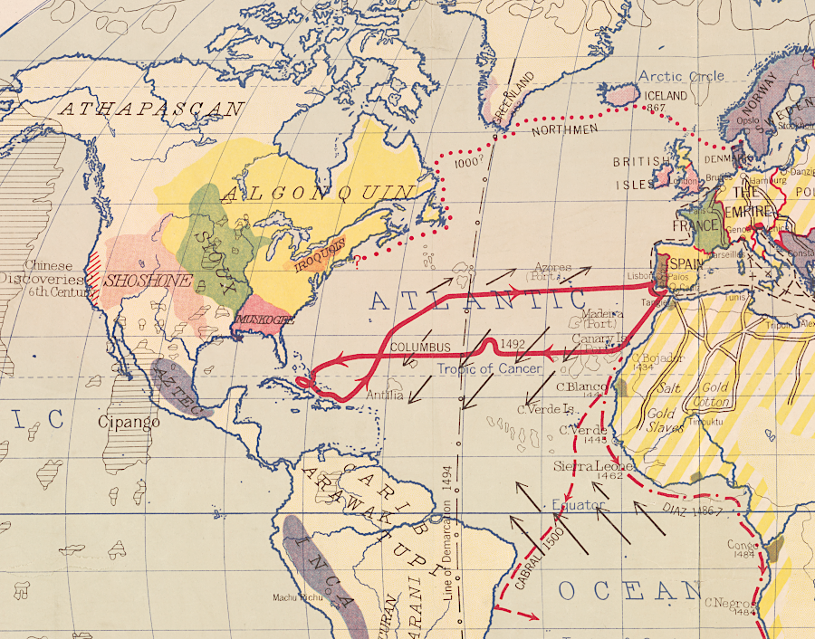
before and after Columbus, people already living in North Americans interacted with European - and possibly Chinese - explorers
Source: Library of Congress, World of Columbus, 1492 (Hart-Bolton American history maps, 1917)
As inland trading partners shared stories, Virginia natives would have learned about the Vikings even if the Vikings never got to Virginia itself. Some objects associated with the new visitors may have been carried south to Virginia as cultural exchanges occurred. Direct trade between Virginians and Europeans would not become an option until sailors began to arrive regularly on the Virginia coast in the 1500's. Europeans brought iron objects that could hold a sharp edge, providing great functional value in forested Virginia.
Most of those early European visitors to the New World were Spanish. Rulers in England, France, the Netherlands, and the German states had not established sufficient control over their societies to amass fortunes large enough to fund speculative explorations across the Atlantic Ocean. The entrepreneurial Italian cities like Genoa and Venice lacked sufficient assets to sponsor expensive expeditions into the unknown, with no immediate return on investment.
King John of Portugal could have sponsored expeditions westward, seeking whatever might be on the other side of the Atlantic Ocean. The Portuguese did sail to India, the Spice Islands, Japan, and China. Prince Henry the Navigator and other Portuguese leaders were looking south, not westwards. Bartolomeu Dias navigated around the southern tip of Africa in 1488, demonstrating the ability to bypass the land trade controlled by the Ottoman Empire.
However, Columbus was rejected by the Portuguese. Spanish monarchs King Ferdinand of Aragon and Queen Isabella of Castille took the gamble. They financed the trip in 1492 that led to European colonization of the New World. After Columbus "sailed the ocean blue" in 1492, Spain dominated the transformation of cultures in the Caribbean, Mexico, Central America, and South America.
Columbus was not expecting to find cultures with less-advanced technology than his own. He hoped to meet Japanese or Chinese with silks to trade, or "Indians" with rare spices that would be of high value in Europe. After finding Arawak people such as the Taino, the Spanish created a pattern of discovery, conquest, and settlement that enriched Seville and other Spanish towns while impoverishing large swaths of the New World.
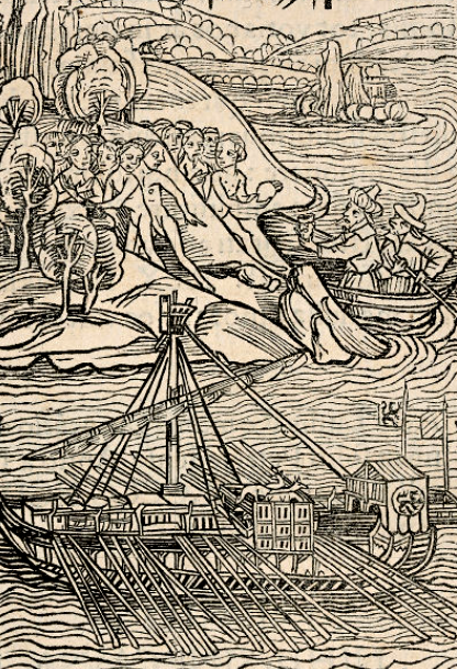
after Columbus arrived in the Caribbean and "discovered Indians," Spaniards sought to enslave them to mine gold and provide food
Source: Osher Map Library, The Basle 1494 Columbus Letter
In Mexico and Peru, pre-existing societies were looted of great wealth. Ponce de Leon was the first Spanish explorer in "Florida," that part of the North American continent closest to Cuba and Puerto Rico and therefore of greatest interest to the Spanish. He and other explorers such as Hernando de Soto found no stockpiles of metals, no jewels, and only a few pearls.
Most significantly, there were few concentrations of Native Americans that could be exploited for their labor. The Spanish focused on occupying other territories and largely ignored North America.
The Portuguese had little interest in the New World, after opening trade with the Spice Islands and India. According to their interpretation of international law, the Portuguese had no right to occupy any of what became Virginia. Spanish monarchs had negotiated zones of influence in the New World in the 1493 Treaty of Tordesillas and Pope Alexander VI validated their claims.
The Portuguese got the Pope's authorization to settle Brazil, but that land initially offered little beside a wood that produced a dye for cloth. The Portuguese were slow to settle Brazil, deferred to the Spanish in the Caribbean, and played no significant role in exploring or settling North America.
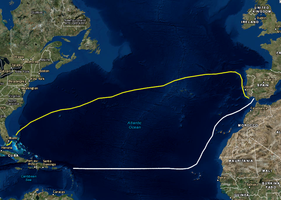
in the 16th, 17th, and 18th Centuries, Spanish fleets sailed from Seville south towards the Cape Verde Islands and then caught the northeasterly trade winds to reach the Caribbean (white line), returning home from Havana to northern Spain by catching the Gulf Stream and then westerly trade winds (yellow line)
Source: ESRI, ArcGIS Online
The Pope's authority was useful for just Spain and Portugal. The Treaty of Tordesillas did not prevent other nations from exploring and establishing their own settlements in the Western Hemisphere. A wide variety of European nations competed to discover and then claim portions of North America, and portions of South America as well. All of the European nations used the "Right of Discovery" as a legal basis for ignoring the obvious fact that the land was already discovered and occupied.
Only five years after Columbus found islands in the Caribbean, John Cabot traveled to North America for King Henry VII of England. Juan de la Cosa produced the first known map of the North American shoreline in 1500. By 1502, Amerigo Vespucci had sailed south along land extending south of the equator.
Writer Matthias Ringmann and mapmaker Martin Waldseemüller concluded that Vespucci had sailed along the eastern edge of a continent surrounded on all sides by oceans, and not connected to Asia. In 1507 Waldseemüller published a map with "America" written across what is now Brazil.
Ringman rather than Waldseemüller probably coined the word meaning "land of Amerigo," in recognition of Vespucci. Ringman created the name by adding the Greek "gen" ("earth") to "Amerigo," then latinizing Amerigen to America. The "gen" appendage could also allow Amerigen to be interpreted as "born new" and "No-place-land," and Ringman was fond of wordplay.
America became recognized as the name for a fourth part of the world in addition to Asia, Africa and Europe, especially after Balboa cross the Isthmus of Panama in 1513 and Magellan sailed around the tip of South America into the Pacific Ocean in 1520. Gerardus Mercator applied the name to all of the New World, with both North America and South America on his 1538 map.
However, the Spanish thought Vespucci had somehow created the name to honor himself. Spanish officials did not use "America" on maps for two centuries.1
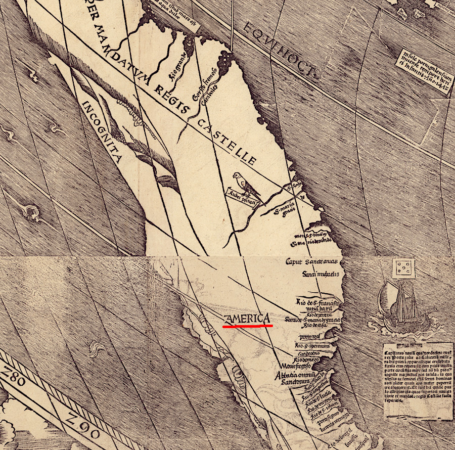
the label "America" was applied in 1507 on the first map to identify that Europeans were exploring a continent separate from Asia
Source: Library of congress, Universalis cosmographia secundum Ptholomaei traditionem et Americi Vespucii alioru[m]que lustrationes (Martin Waldseemüller, 1507)
At various times, the Chesapeake Bay and the Virginia coastline was explored by the Spanish, French, and Dutch as well as the English. Even the Swedes established a colony nearby in what is now Delaware. The Swedes usurped the fur trade of the Susquehannocks, while the English colonies of Maryland and Virginia competed between themselves. The Swedes popularized the construction of log cabins in North America.

the Swedes colonized on the Delaware River in 1638, next to the Dutch
Source: John Carter Brown Library at Brown University, Le Canada faict par le Sr de Champlain. ou sont la Nouvelle France la Nouvelle Angleterre (by Samuel de Champlain, 1664)

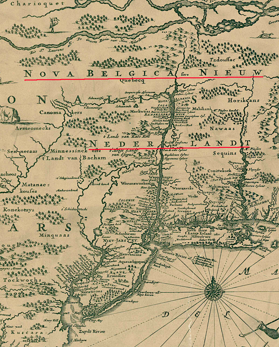
what is now Albany, New York started as a Dutch fort
Source: John Carter Brown Library at Brown University, A Map of a Large Country Newly Discovered in the Northern America Situated between New Mexico and the Frozen Sea (by Louis Hennepin, Louis, 1698)
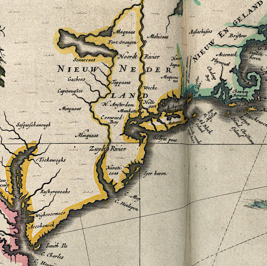
the Dutch settled on the Hudson River and conquered the Swedish colony on the Delaware River in 1655
Source: National Archives, Novi Belgii, quod nunc Novi Jorck vocatur, Novae que Angliae and partis Virginiae (c.1671)
Virginia saw few Spaniards, and few French even during the French and Indian War. As a frontier, Virginia was primarily on the edge between English and Native American societies. Immigrants came from France and the German states, but accepted the authority of British colonial governments.
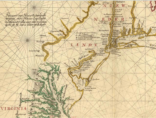
New Netherland - Dutch settlements and claims between Virginia and New England in 1639
Source: Library of Congress, Pascaert van Nieuw Nederlandt Virginia,
ende Nieuw-Engelandt verthonendt alles wat van die landin by See, oft by land is ondect oft Bekent
Jamestown and the small plantations scattered across Tidewater Virginia were international seaports from their very beginning. The plantations in Tidewater reflected an English culture transplanted and modified by experiences in the New World, but these plantations were not isolated from the other side of the Atlantic Ocean.
Cultural diversity on the ships visiting plantation wharfs throughout Tidewater was high, reflecting the wide variety of ports from which sailors were recruited. Early Virginia was not an "English-only" culture, especially after the massive importation of slaves started in the early 1700's and Virginia was transformed into a tobacco-centered economy.
The mix of cultures in Virginia was not independent of the national rivalries in Europe. Tensions between European powers competing for wealth and military control in the New World created tensions in the early settlements of Virginia. Though the Jamestown colony was desperate for settlers in its early years, rivalries were intense enough to permit hanging one of the members of the council as a Spanish spy.
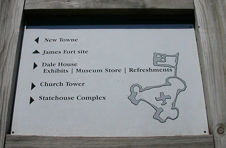
map of Jamestown fort (used on modern interpretive sign) originally obtained through a spy by Spanish Ambassador Zuniga in London
Still, Virginia welcomed most immigrants, no matter what alliances England was joining or fighting. At various times, Virginia landowners struggled to recruit Huguenots, Puritans, Royalists, refugees from the Palatinate, and virtually every other Northern European group that faced economic distress or persecution at home - even Catholics.
The international context was always a factor in the defense and the economy of Virginia. Currency used in the colonial era shows how Virginia was tightly connected to foreign lands. Less is known about the variety of languages spoken on the wharfs, but according to one writer in 1724:2
To potential European immigrants, Virginia was not home. It was somewhere else, way out there in the wilderness. In such a place, new riches could be discovered and adventurers could get a second chance at life. People who could never afford land in their native country could create an inheritance of value for their children.
Early exploration by Cabot and others gave the English monarchs an opportunity to claim the continent by Right of Discovery. However, it was the permanent settlement starting in 1607 that determined Virginia would be based on an English model. Had the Spanish settled Virginia, the colonial churches might have mirrored the missions in Florida. The population might have been concentrated in towns with a Catholic church at the center. If the French had occupied the Chesapeake Bay, the colony could have been based on fishing and fur trading rather than tobacco.
The English were late-comers to North America.
The Spanish were the first European country to explore into the interior of North America, and to create settlements on the coast below Newfoundland. Ponce de Leon made the first attempt to create a permanent colony in North America when he brought seeds and livestock in 1521 to a site near modern-day Tampa. Lucas Vasquez de Ayllon tried in 1526 to create a settlement called San Miguel de Guadalupe in modern-day Georgia.
Hernando de Soto ventured through what today is North Carolina in 1540. The de Soto expedition was not a success, but the Spanish learned the coastline and southeastern interior of North America better than any European rival. They could have moved north along the Atlantic Ocean edge from their base at Havana and established the first colonies on the Outer Banks, Chesapeake Bay, and Cape Cod.
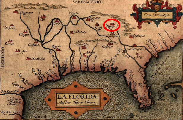
Hernando de Soto stayed at Xuala (near modern-day Morganton, NC, 60 miles south of North Carolina/Virginia border) in 1540, and Juan Pardo returned in 1567
Source: Library of Congress, Peruuiae avriferae regionis typus / Didaco Mendezio auctore. La Florida / auctore Hieron. Chiaues. Guastecan reg. (1584)
The Spanish crown offered little support for settlement north of the Caribbean. The priority in Madrid was to protect the Spanish treasure fleet sailing home from the Caribbean to Seville, not to expand Spanish settlement north along the Atlantic shoreline.
King Philip II did authorize colonization of La Florida, but did not provide substantial support from his own treasury. Pedro Menendez de Aviles had to risk his own wealth to establish a base.
The French sought wealth initially by trading for furs along the St. Lawrence River. The French built Fort Caroline on the St. John's River in 1564, in what today is Jacksonville, Florida, but the Spanish were provoked enough to send a fleet to destroy the fort. The French tried to attack first, but a storm wrecked their ships. The Spanish then captured and executed the survivors, destroyed the French fort, and established St. Augustine in 1565.
The Spanish did try to defend the southeastern coastline, and build an overland supply line connect it to the settlements in Mexico.
In 1566 Pedro Menendez de Aviles moved north of St. Augustine to build another military base called Santa Elena, at modern-day Parris Island in South Carolina. In 1567 Juan Pardo left Santa Elena on an attempt to define an overland path to the mines in Mexico.
Pardo explored inland into North Carolina, and he returned to Hernando de Soto's camp at modern-day Morganton, North Carolina. A combined Spanish-Native American military force sent on a raid from that base in 1540 across the Blue Ridge may have brought the first Europeans into a part of Virginia away from the Chesapeake Bay.
Pedro Menendez de Aviles did send an expedition to the Chesapeake Bay in 1566, the same year he founded Santa Elena. The Spanish looked for the rumored Strait of Anian, which in theory would provide a direct water route to the Pacific Ocean. The ship failed to find the bay's entrance, but in 1570 another Spanish initiative started the first colonial settlement in Virginia.
Jesuit missionaries led by Father Juan Baptista de Segura accompanied Paquiquineo/Don Luis on his second expedition to the Chesapeake Bay. The Jesuits went onshore on the northern bank of the James River, but walked across the peninsula to the Native American community at Kiskiak on the Rappahannock River. That hike from the James River to the Rappahannock River may have been triggered by a desire to live closer to the religious center of the Native Americans, so Catholics could challenge the Native American spiritual leaders based at Werowocomoco.
The Jesuits made enemies rather than friends, however. All but one of the Europeans were killed in early 1571.
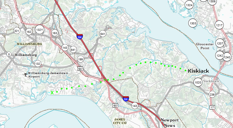
possible route of Father Juan Baptista de Segura and his Jesuits to Kiskiack in 1570
Map Source: US Geological Survey, National Atlas
Sir Francis Drake burned St. Augustine in 1586. The Spanish base at Santa Elena was abandoned in 1587, and Spanish forces concentrated at St. Augustine. After the defeat of the Spanish Armada in 1588, the Spanish never again tried to establish a colony north of St. Augustine. They also failed to use military force to expel the English who settled at Jamestown in 1607.
The French threatened to constrain the westward expansion of Virginia for 80 years. Rene Robert Cavelier, sieur de La Salle, formally claimed French ownership of the entire Mississippi River watershed on April 9, 1682 after he led a party from the Illinois River to the edge of the Gulf of Mexico. La Salle named the area Louisiana, in honor of French King Louis XIV. The French created settlements along the Gulf of Mexico in order to control traffic on the Mississippi River and assert their claim to that watershed.
The French were less interested than the English, Dutch, and swedes in populating North America. French settlement outside of Montreal, Quebec City, and New Orleans were sparse. New France in the north and Louisiana in the south were valued for their trade in raw materials. Native American tribes brought furs to depots, for which the French traded guns/shot/gunpowder, liquor, metal tools and pots, textiles, and other manufactured items.
Catholic priests and courier de bois (fur traders traveling the rivers, including children of French fathers and Native American mothers) lived in the backcountry. There was little interest in farming other than to sustain the small resident population of French colonists. In contrast to the English in the southern colonies, the French did not focus on staple crops like tobacco.
The historian Francis Parkman described the different approaches to settlement between the French and the English, in words that reflected the prejudices of his time:3
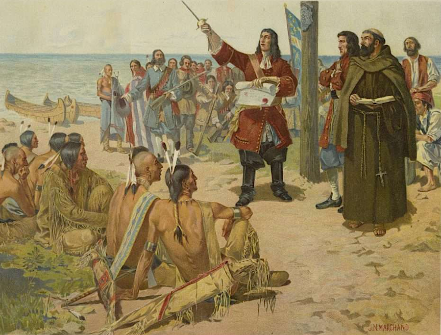
La Salle claimed all of the Mississippi River watershed in 1682, and the French retained it until 1763
Source: Albert and Shirley Small Special Collections Library, University of Virginia, (posted online by Encyclopedia Virginia), La Salle Taking Possession of Louisiana, A.D. 1682 (by J. N. Marchand, 1903)
The French started occupying lands along the St. Lawrence River in 1605. Those settlements provided access to the fishing grounds of the Great Banks. They were far north of the English colonies, but the Virginia colonists always viewed French settlement as a threat. Virginia colonists destroyed Port Royal in 1613, and an English force under a former governor of Virginia (Francis Nicholson) captured it again in 1710.
The dance between the French and English lasted until 1763.
Conflict over expansion by both nations into the Ohio River valley led to the French and Indian War, starting with what the French described as the "assassination" at Jumonville Glen of the leader of the French detachment.
Virginians triggered that conflict with their efforts to grant the Loyal Company control over the region at the forks of the Ohio (today's Pittsburgh) and lands north of the Ohio River. - Until the 1760's there was no reliable way to determine longitude. Virginia leaders, unfamiliar with east-west distances, feared the French along the Ohio River were only a short march away from invading the western settlements.
If French settlements in the Ohio River watershed were a serious threat, then a military response was justified. The 1755-1763 French and Indian War ended with complete expulsion of the French from North America, except for two small islands at the mouth of the St. Lawrence River.
before longitude could be measured accurately, mapmakers suggested the Pacific Ocean was only a 10-day march from the headwaters of Virginia's rivers
Source: Library of Congress, A mapp of Virginia discovered to ye hills, and in it's latt. from 35 deg. & 1/2 neer Florida to 41 deg. bounds of New England (by John Ferrar, c. 1667)
Swedish and Dutch colonists colonized locations between the English settlements in Virginia and New England. As noted by a visitor to Virginia in 1647, there was concern in Jamestown:4
the Dutch tried to colonize the land between New England and Virginia
Source: Library of Congress, Nova Anglia Novum Belgium et Virginia (by Jan Jansson, 1638)
The life of the New Sweden colony was brief, but it created two significant impacts on the English colony of Virginia. Fort Christina (now Wilmington) was founded in 1638. By then Lord Baltimore had displaced William Claiborne of Virginia from his fur trading base on Kent Island, disrupting the Virginia-Susquehannock fur trade.
The Susquehannocks traded instead with the Swedes and the Marylanders. That disruption created an opening for Gov. William Berkeley, who arrived in Virginia in 1641, to establish control over Virginia's trade with Native Americans.
By 1676, colonists were upset about Berkeley's efforts to maintain peaceful relations with Native Americans. The governor's desire for private profits from the fur trade were seen as interfering with his responsibility to protect settlers moving north and west into territory previously controlled by Native American. The failure of the colonial government to respond to attacks on settlers in the borderlands led to Bacon's Rebellion in 1676.
The Swedes also brought that icon of the American frontier, the log cabin, to the New World. It was a new style of housing for the Virginia colonists. There were no log cabins built at Jamestown; that form of housing arrived with the Swedes. The Virginia colonists came originally from England, where trees from forests were too valuable for constructing cabins.
The Swedes surrendered their claims near the Delaware River to the Dutch in 1655. During the Anglo-Dutch wars, Dutch raiders sailed into the Chesapeake Bay to seize/burn the tobacco fleet.
Roughly 9,000 people ended up living in New Netherland, and they focused on farming like the English colonists. After 40 years of settlement the Dutch were forced to surrender their North American colonies to the British in 1664. New Amsterdam was renamed New York, the North River was called the Hudson River by the English, and the South River became the Delaware River.
The Dutch recaptured Manhattan Island in 1673, renaming it "New Orange," but returned it to the English in 1674. Ironically, the Dutch leader in 1674 was crowned king of England in 1688 after the Glorious Revolution. William III (half of "William and Mary") was the enemy of the English during the Third Anglo-Dutch War, but became the king who ruled over Virginia 15 years later.5

European claims to North America in 1719, from west to east: California, New Mexico, New France, Florida, Virginia
Source: David Rumsey Historical Map Collection, Charte von Europa. Charte von Asia. Charte von Africa. Charte von America (by Johann Baptist Homann, 1719)
The Spanish and the French were the two European nations that acquired substantial lands in North America and threatened to establish permanent control over large swaths of the continent.
The Spanish claims to Florida and Louisiana became entangled with French diplomacy and wars with England. In 1763, Spain had to transfer East Florida and West Florida to Great Britain when its ally France was defeated in the French and Indian war/Seven Years War. In return, the British returned the captured port of Havana to Spain.
The Proclamation of 1763 created the new colonies of East Florida and West Florida. They stayed loyal to King George III and Parliament during the American Revolution. In 1783, Great Britain transferred the colonies back to Spain. The United States finally acquired them in the 1819 Adams–Onís Treaty with Spain.
In 1763 the French transferred Louisiana, including New Orleans and the lands west of the Mississippi River to the Rocky Mountains, to Spain. Napolean forced Spain to return that territory to France, and he then sold it to the United States in 1803. The Louisiana Purchase was a $15 million land deal. It was the first time a European nation recognized that the United States included territory west of the Mississippi River.
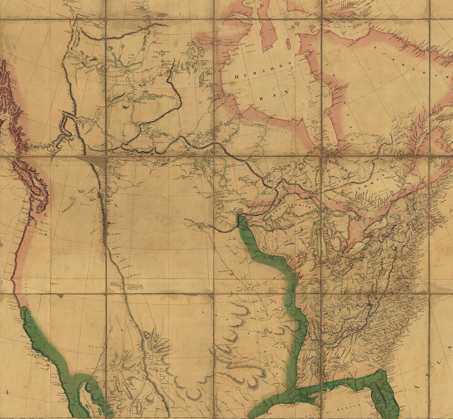
Napoleon did not know what he sold and Thomas Jefferson did not know what he bought with the Louisiana Purchase in 1803
Source: Library of Congress, A map exhibiting all the new discoveries in the interior parts of North America (by Aaron Arrowsmith, 1802)
Spanish claims to Texas and the Southwest were extinguished after Mexico became independent in 1821. The United States won the Mexican-American War, and the 1848 Treaty of Guadalupe Hidalgo transferred the Southwest and California to the United States. That land acquisition finally created a nation that extended "from sea to shining sea."
The United States became an imperial power with overseas colonies under President William McKinley. Hawaii was annexed in 1898, and Spain ceded its authority over the Philippines after the Spanish-American War. Hawaii was governed as a territory until being incorporated into the union as a state in 1959, while the Philippines became an independent nation after World War II.
The United States and European nations relinquished control over most occupied areas and colonies in the 1950's and 1960's. However, in 2026 President Trump reversed long-standing policy and asserted a desire to make Canada into the 51st state.
He threatened to destroy the North Atlantic Treaty Organization and use military force to seize Greenland from Denmark. If he succeeded in acquiring the 836,000 square mile island, it would be the largest land acquisition in the nation's history.
The Louisiana Purchase (827,987 square miles) is the largest single expansion of US territory to date. Other major expansions of US territory include the purchase of Alaska in 1867 (591,000 square miles), the Mexican Cession after war in 1848 (529,189 square miles), and the annexation of Texas (389,166 square miles) in 1845.6
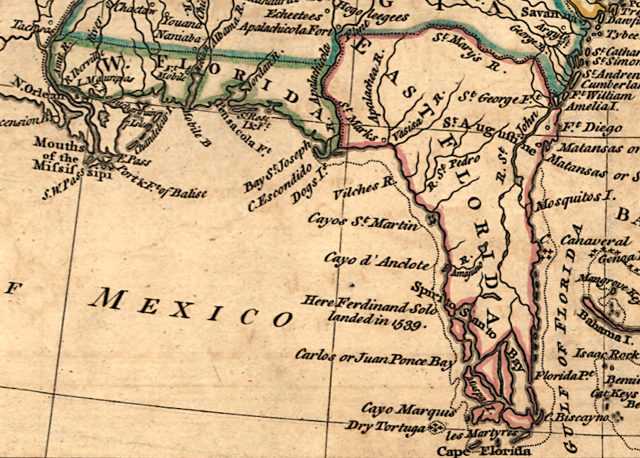
Spain was forced to transfer East and West Florida to Great Britain in 1763 and got them back in 1783; the United States ultimately acquired that land in 1819
Source: Library of Congress, A map of the British dominions in North America, according to the Treaty in 1763 (by Peter Bell, 1772)
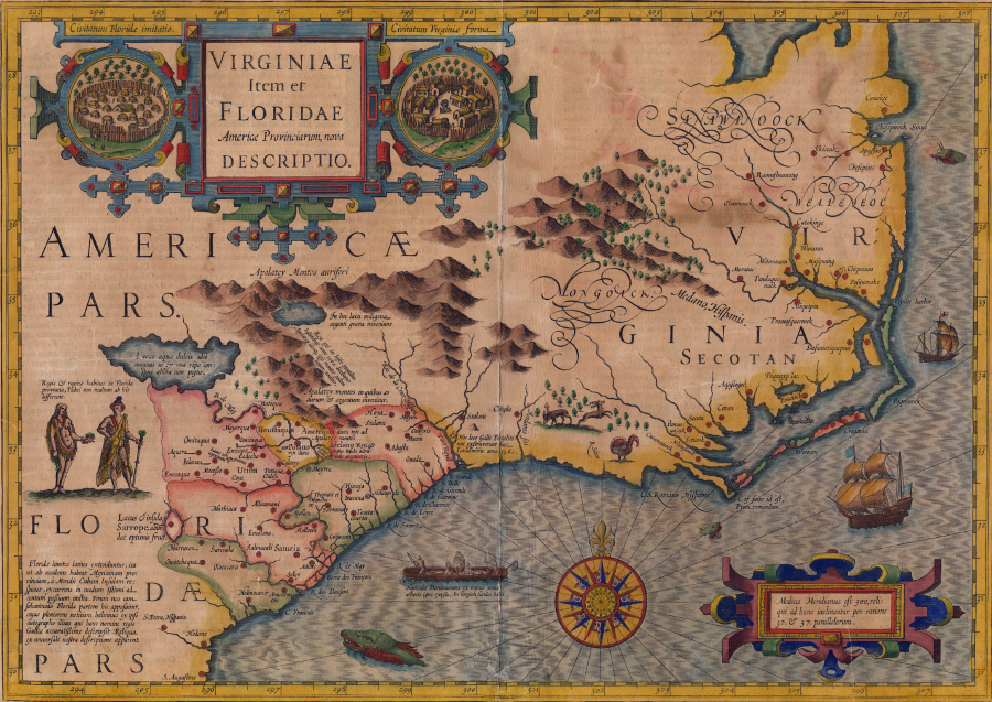
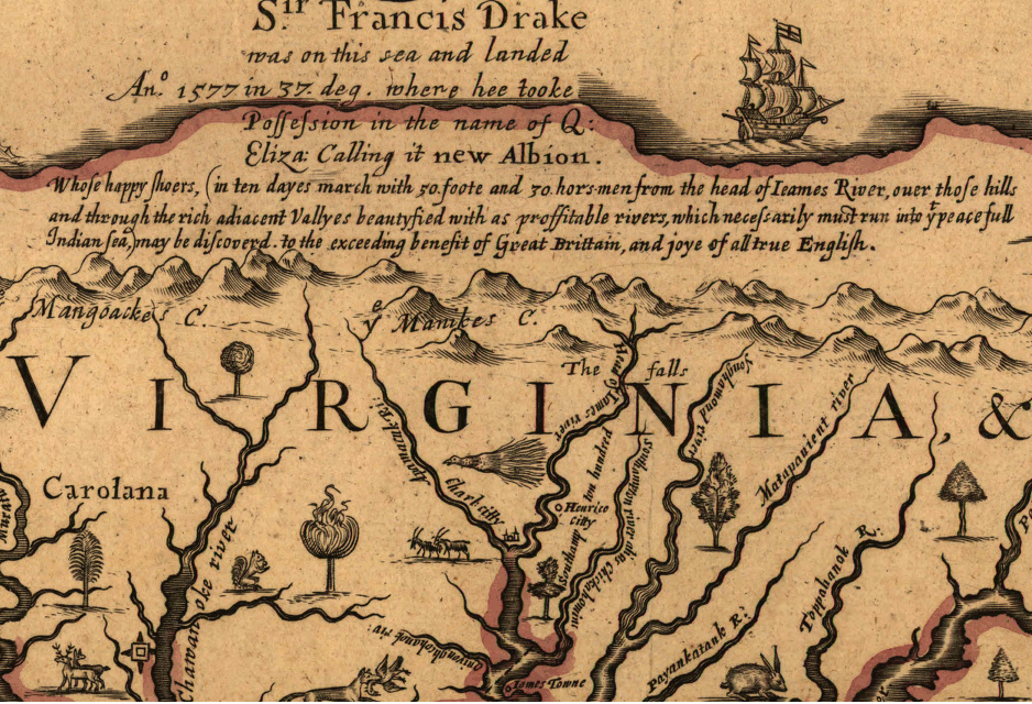
Spanish and French settlements were established in what became Virginia, South Carolina, Georgia, and Florida before Jamestown was settled in 1607
Source: North Carolina Department of Cultural Resources, Virginiae Item et Floridae, Americae Provinciarum, nova Descriptio (published c. 1609)
Source: Jefrey the Librarian, First Colonies: 1565-1700 | American Colonial History | Jamestown, Plymouth, Puritans, Quakers
Source: Jefrey the Librarian, Thirteen Colonies, 1700-1750 | Britain, France & Spain | North American colonies | US history
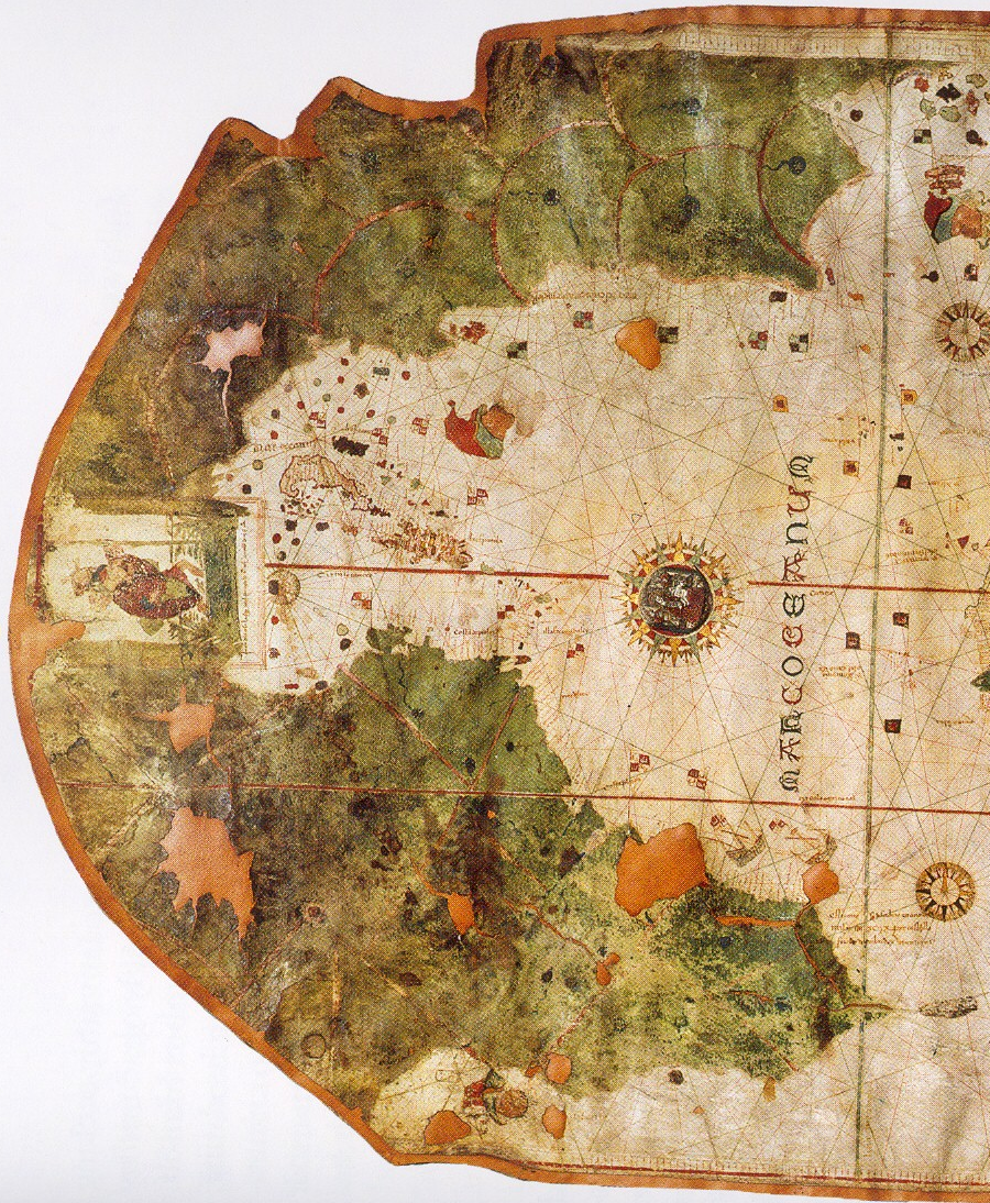
the first known map showing the coastline of North America reflected the lack of detailed information, such as the existence of the Chesapeake Bay
Source: Wikipedia, Map of Juan de la Cosa (1500)