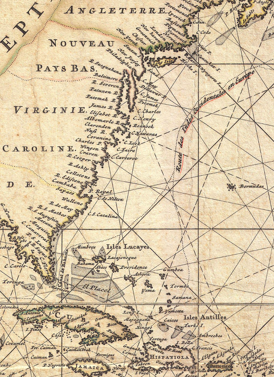
Spanish Exploration and Settlement in the Southeast
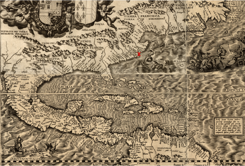
in the first two centuries of Spanish colonization in the New World, the Chesapeake Bay (red X) was on the edge - far from the focus of Spanish settlements that stretched from Mexico into South America
Source: Library of Congress, Americae sive qvartae orbis partis nova et exactissima descriptio (Diego Gutierrez, 1562)
The Spanish were the first Europeans to explore and to establish a settlement in North America, and also in what today is Virginia.
Despite initial failures, the Spanish tried multiple times to settle North America. Comparable initiatives by English venture capitalists came long after the first Spanish efforts to start colonies in the 1520's. The Spanish ultimately succeeded in building St. Augustine in 1565. It became the first town in North America permanently occupied by European colonists, and remains today the oldest such town in North America.
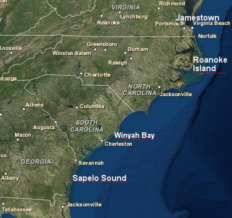
St. Augustine was settled almost 20 years before the first English attempt to live on the western side of the Atlantic Ocean, rather than just sail along the coastline. Sir Walter Ralegh sent people to the Outer Banks and Roanoke Island several times, starting with a scouting expedition that in 1584 that left no one behind to overwinter. Over 40 years passed between the first Spanish colonization attempt in 1521 and the first success in 1565. The first English settlement attempt in North Carolina was in 1585, and it required over 20 years before Jamestown was settled in 1607.
The English settlements in Virginia (1607) and Massachusetts (1620) are over 80 years too late to be the first colony started by Europeans on the North American continent. Virginia tourism advertisements fail to note that the settlement at Jamestown was started four decades after the Spanish started the first successful European town in North America, and about 20,000 years after Native Americans first colonized the area and perhaps 3,000 years after they built their first permanently-occupied towns.
Spanish explorers mapped the North American coastline north of Florida up to Newfoundland, Labrador, and Greenland by 1501. The southeastern coast of North America was named by Ponce de Leon in 1513, when he set foot on land during "Pascua florida" (the Feast of the Flowers). That was the same year that Vasco Nunez de Balboa crossed the Isthmus of Panama and named the Pacific Ocean.
Since Virginia was originally the northern part of Florida, the first European name for Virginia was based on the Spanish term for Easter. Florida and the rest of the continent was considered to be part of the Viceroyalty of New Spain. Later French settlers would assert a claim to Lower and Upper Louisiana. Seven decades after Ponce de Leon named Florida, a rival group of Europeans named the region near the Outer Banks as Virginia to honor their Queen Elizabeth, the "virgin queen."
The Europeans were not the first to apply names to parts of North America. The original name for the area that was used by very first settlers, 20,000 years ago, is unknown.
When the English reached Jamestown in 1607, the territory controlled by the paramount chief known to the English as Powatan was called Tsenacomoco or Tsenacommacah. Powhatan's father began to gain control over the area after the Spanish tried to create a colony in Virginia in 1570. When the first Spanish ships sailed along the Atlantic Coast of North America, "Tsenacomoco" was not established yet.
By the time investors in London started a settlement at Jamestown in 1607, the Spanish had been exploring, conquering, enslaving, converting, and settling at different places in the New World for over a century. In 1521, Ponce de Leon made the first attempt to establish a permanent settlement in North America. In the 1560's, Spanish officials sent a military expedition inland that explored southwestern Virginia. In 1570, Jesuit priests tried to establish a settlement on what is now called the York River. The English did not arrive at Roanoke Island for the first time until 1584.
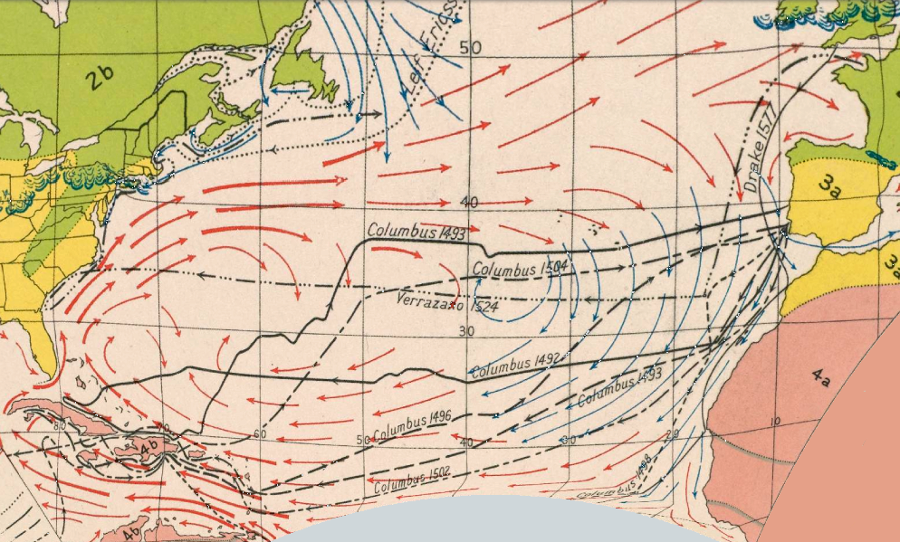
Spanish exploration of the New World was concentrated in the Caribbean initially because wind patterns made it easier to sail to latitudes far to the south of Virginia - but Spanish fleets returning to Europe used westerly winds that brought ships past Florida, exposing them to attacks from any pirate base located along the coastline of North America
Source: Atlas of the Historical Geography of the United States, Natural Regions, Glaciated Areas, Ocean Currents and Maritime Explorers' Routes (Plate 1a, digitized by University of Richmond)
The Spanish explored the eastern coast of North America extensively and established settlements in several locations along the Atlantic Coast in order to:
1) discover unknown riches that may exist in unknown territories
(The wealth of Mexico and Peru was a surprise - perhaps the interior of North America would surpass it.)
2) block French settlements in "La Florida"
(The oldest continually-settled city on the North American continent that was started by European colonists is St. Augustine, founded in 1565 after the French tried to create two colonies on the southeastern coastline.)
3) block Dutch, English, or French privateers/pirates from creating a base of operations in the Chesapeake Bay to raid the Spanish treasure fleet sailing from the Caribbean
(Privateers had authorization from a government, so they were essentially mercenaries working on commission. Pirates had no "political cover" but could keep all the loot. The distinction was rarely 100% clear in practice.)
4) convert the Natives to Christianity
(In Spain the king/queen controlled appointments of all Catholic officials, and the monarchs determined that Native Americans were humans to be Christianized rather than enslaved)
5) find a sea passage to China and the Spice Islands
(Columbus had justified his 1492 voyage as a search for direct access to that profitable trade, while the Portuguese were discovering a different route via Africa and the Indian Ocean)
The Spanish were not the first Europeans to reach North America. About 1,000 years ago, five centuries before Columbus sailed to the Caribbean in 1492, the Vikings built simple fishing camps in Newfoundland and Labrador. The focus on the first time of European colonization ignores how Asians were regularly visiting North America for thousands of years. People traveled regularly between Chukotka (in modern Russia) and Alaska, and that travel may date back to when the Bering Strait first emerged as a waterway.1
European colonization of the North American continent began soon after Columbus's discoveries. The Spanish started permanent colonies in the Caribbean, and Santo Domingo (founded 1496) remains the oldest continuously-occupied colonial settlement in the New World.
The Spanish were not alone in trying to explore and settle the New World. There was competition from other European states, but initially they avoided the Caribbean because of the Spanish presence there.
During the 1500's, English and French explorers looking for fishing grounds determined the outlines of the North American coast north of New England. The sailors constructed temporary camps on Newfoundland when fishing off the coast. Those camps remained as isolated, single-purpose communities, occupied only during the time when cod were being caught and dried for transport back to Europe.
In 1541-3, the French tried to establish a permanent settlement on the St. Lawrence River. That failed, but the French returned in 1603 to start again at St. Croix Island and Nova Scotia. In the six decades between those efforts, the French sought twice to build colonies on the southeastern coast of North America.
The settlement at Charlesfort (1562) collapsed before the Spanish had an opportunity to attack it. The Spanish destroyed the later French colony at Fort Caroline (1565), and then Spanish soldiers executed Jean Ribault and nearly all of his shipwrecked colonists in a massacre on a Florida beach.
After that experience, France avoided conflict with Spain by settling much further north of St. Augustine. By choosing St. Croix and then Quebec, the French left an unoccupied zone on the eastern edge of the continent.
The English, Dutch, and Swedes focused their North American colonization efforts in that gap between the French and Spanish, but only after the military power of Spain was diminished by the failure of its sleet (the Spanish Armada) to conquer England in 1588.
The Caribbean islands and Mexico/Peru became Spain's primary targets for exploitation, after the discovery of accumulated wealth that could be looted and large populations that could be exploited. The Spanish were aggressive in protecting their claims to the New World, but did not have the resources to colonize the entire North American coastline. Lack of available soldiers prevented Spain from challenging all the European competitors occupying "northern Florida," and even Caribbean islands were left with few Spanish settlers.
Spanish occupiers came to America immediately after completing their 700-year reconquest of the Iberian Peninsula. The extension of the reconquista to North Africa was blocked when local tribes in Morocco were able to defend their territories and culture, including the Muslim faith.
The Portuguese, encouraged by Prince Henry the Navigator, were the first Iberians to explore far offshore. They conquered Ceuta and set up forts on the West African coast. The Berbers in North Africa blocked the land route south, but the ocean highway was open to Portuguese ship captains. Sailing south of the Sahara Desert could open direct trade for the gold of Mali, bypassing the middlemen who brought it to the Mediterranean coast.
The potential for other trading opportunities led the Portuguese to explore even further south along the west cost of Africa. After rounding the Cape of Good Hope at the tip of Africa, trade with India and Asia occupied the Portuguese. They were the first European nation to bypass the land routes controlled by Muslims, opening shipping routes to the source of spices.
The Portuguese had the expertise to explore westward into the Atlantic Ocean as well, but the capacity of that small country was limited. Portugal lacked the population and military capacity even to occupy the territories they "discovered" in Africa. They also found the trade in gold and slaves from Africa, and the trade in spices from East Asia, sufficiently rewarding. Sailing into the unknown regions of the Atlantic Ocean on a speculative "what might be out there" journey was a low priority, when the already-known opportunities in Africa and Asia were so valuable.
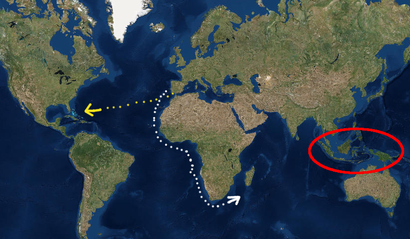
Spain had a different perspective. The Portuguese success in Asia also caused the Spanish to look for a path to the Spice Islands, ideally a route not already dominated by their neighbor on the Iberian peninsula. The Spanish did establish tiny enclaves in North Africa such as Melilla, but also directed their expansion westward towards North America. Columbus miscalculated the distance to the Indies, and saw an opportunity to create a new trading route via the Atlantic Ocean.
After lengthy negotiations, Spanish monarchs Ferdinand and Isabella supported Columbus's initial journey west. Their dream was to open a new route across the Atlantic Ocean to get access to the spices, without paying high costs to deal with rivals. The Muslims already controlled the land route, and the Portuguese already controlled the sea route via Africa. Supporting an Italian willing to sail west into the unknown was a speculative investment for Ferdinand and Isabella, but offered the best opportunity for Spain.
the Spanish (yellow dots) sailed west across the Atlantic Ocean because the Portuguese already dominated the potential to go south (white dots) past the Cape of Good Hope at the tip of Africa to the Spice Islands (red oval)
Source: ESRI, ArcGIS Online
After Columbus returned in 1493, Spanish leaders quickly recognized their opportunity to obtain wealth from the New World and surpass the Portuguese. The Spanish did not limit their explorations to the Caribbean, or their economic strategy to finding just gold. Enslaving the Native Americans was a quick path to profits, first by shipping them to Spain and then forcing them to labor on Caribbean islands. Spanish captains created detailed maps on the southern part of the East Coast starting in 1514, as slavehunters stole Native Americans to replace the declining native populations on Hispaniola (modern-day Haiti/Santo Domingo).
Most, but not all of the Spanish efforts to explore/settle North America came from nearby Caribbean bases on Hispaniola, Cuba, and Puerto Rico. In contrast to the colonization pattern of the English in the 1580's and the first decade of the 1600's, the Spanish rarely sent a fleet of ships loaded with colonists or soldiers directly from Spain to the North American continent. Spain had base stations already established in the Caribbean, and used them effectively to launch expeditions north until St. Augustine was settled permanently in 1565.
The Spanish considered Virginia to be part of Florida, with claims that preceded the discoveries made by Christopher Columbus starting in 1492.
Pope Alexander VI had established one basis for Spain and Portugal to claim all of the Western Hemisphere when he issued his "Inter Caetera" papal bull in 1493. The 1494 Treaty of Tordesillas defined a line of longitude, west of which the Spanish were granted exclusive rights.
The Spanish sphere of influence in the Western Hemisphere was also based on earlier efforts by popes to establish international law. As the Portuguese sailed south to explore the African coast in the 1400's, Pope Martin V granted them exclusive control of lands below the 26°N line of latitude. Pope Nicholas V reaffirmed that boundary in 1455, and Spain claimed those authorities west of the lime of demarcation established in 1494.
Spain asserted control south of the Tropic of Cancer, a line of latitude at 23.43645°N which was well known to sailors. In North America, that gave Spain control over the Straits of Florida and the legal right to block any other European Nation from sailing into the Caribbean or Gulf of Mexico:2
Above the Tropic of Cancer, Spain's interests and ambitions were more limited. It at times lay claim, through expeditions and colonization attempts, to that area and its offshore islands on the grounds of Pope Alexander's 1493 bull. But its primary concern was to safeguard its treasure fleets and prevent the establishment of potentially hostile bases.
Spain's main claim to North America was based on the "right of discovery," actual occupation, and military force rather than on statements by various popes. Areas settled by the Spanish were acknowledged by other European nations to "belong" to Spain. Unsettled land was seen as an opportunity by those other nations to establish a foothold in the Americas, and the French sought to establish colonies in North America long before the English first arrived in 1584.
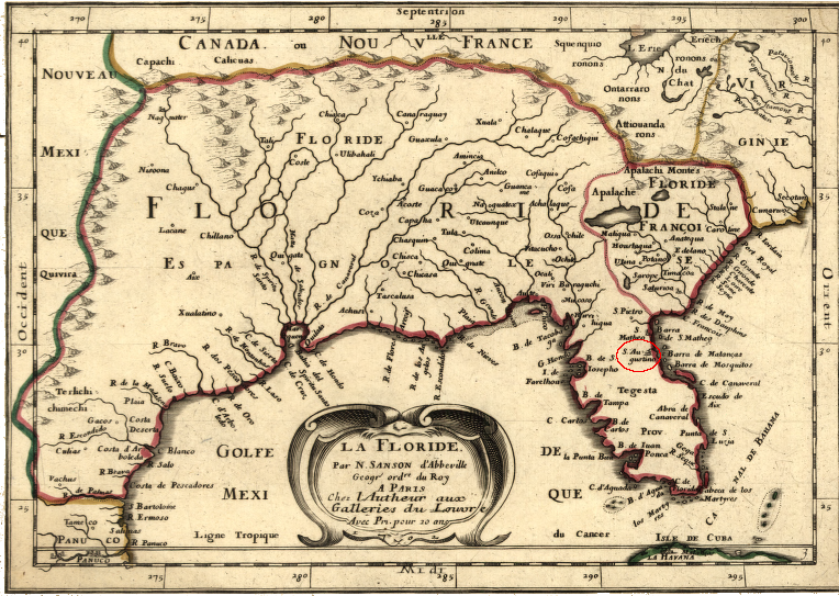
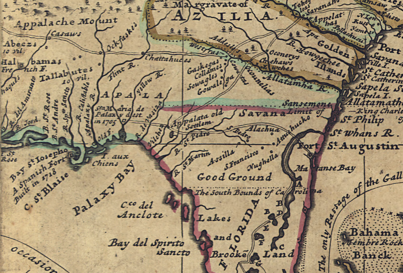
in the 1600's the English and French established claims north of St. Augustine, limiting the extent of the Spanish province of Florida
Source: Library of Congress, La Floride (by Nocholas Sanson, 1657)
Ponce de Leon made the first attempt to create a permanent colony in North America after Columbus's discovery. That attempt occurred eight years after Ponce de Leon led the first major European exploration of the North American continent into Florida in 1513. The 1513 expedition was for discovery, and was not intended to create a permanent settlement.
Ponce de Leon returned in 1521 with 200 people, trying to start a permanent settlement near modern-day Tampa. On the 1521 trip, Ponce de Leon brought seeds to plant and livestock (cattle, pigs, horses, sheep, and goats) to support the colonists.
That first Spanish effort to permanently settle in North America failed. The local Calusa tribe successfully resisted his attempt to occupy their territory. Ponce de Leon abandoned the 1521 colonization project and returned to Cuba, where he died from an arrow wound that he had suffered in Florida.3
After Columbus "discovered" the New World in 1482, the Spanish explored north along the Atlantic Ocean coastline but chose to focus their investment in colonization in the Caribbean, Central America, and South America. After various ships mapped the edge of the continent from the Caribbean to Newfoundland, Spain sent expeditions that explored inland from the Florida and Carolina coast to the Mississippi River and west to Mexico.
Estevao Gomes, a Portuguese pilot working for the Spanish, mapped the New England coastline in 1524. He named Cape Cod "Cabo de las Arenas" and brought Native Americans back to Spain as enslaved people in 1525. That same year, Captain Pedro de Quejo mapped the coastline from Florida to Delaware, sailing along the Virginia shore on that trip but capturing no one who could be enslaved.
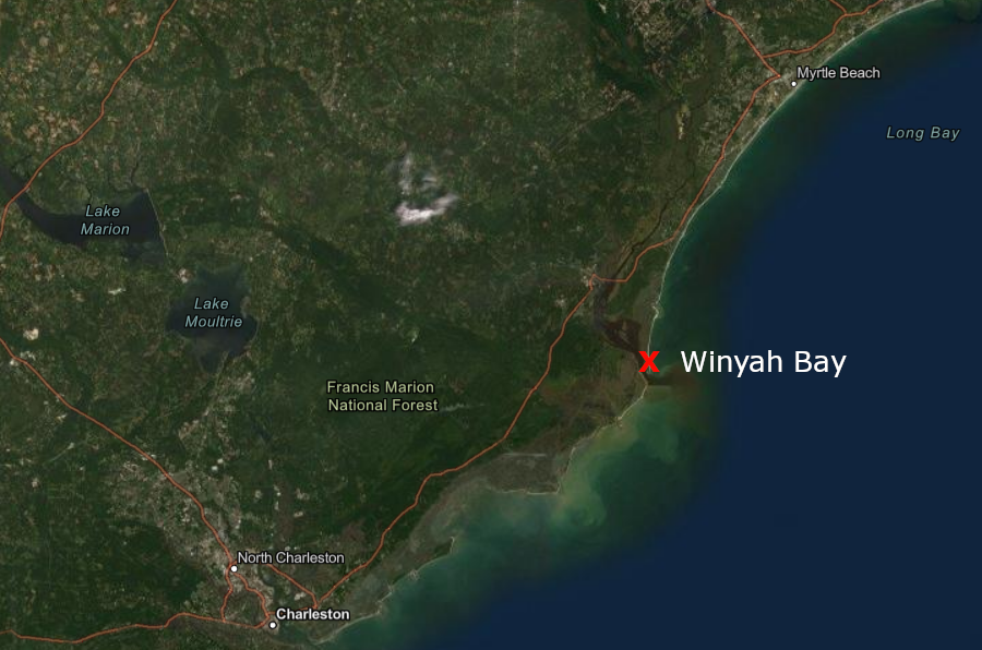
Lucas Vasquez de Ayllon was another Spanish slavehunter in North America. In 1521, two Spanish ships captured about 60 Native Americans near what later was called Winyah Bay in South Carolina. While in Hispaniola (the island shared today by Haiti and the Dominican Republic), Lucas Vasquez de Ayllon acquired one of those captives, a man the Spanish named Francisco de Chicora.
Lucas Vasquez de Ayllon took Chicora to Spain in 1521. There he spun tall tales about mineral wealth in North America, spurring more greed in a country that was already looting gold and silver from Native American nations in Mexico and Peru. His stories succeeded in getting the Spanish to bring him back home to North America. That trip was associated with Lucas Vasquez de Ayllon 's attempt to create a permanent settlement near where Chicora had been captured.
about 60 Native Americans, including one later named Francisco de Chicora, were captured by the Spanish in 1521 at what today is called Winyah Bay
Source: ESRI, ArcGIS Online
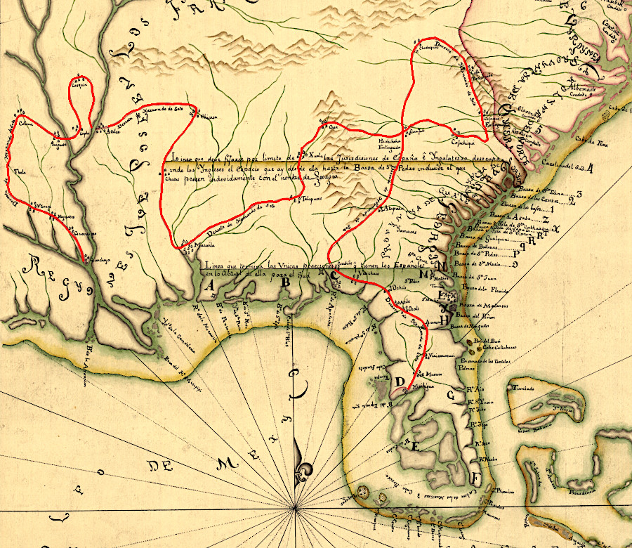
Lucas Vasquez de Ayllon's one significant attempt to create an actual settlement involved a six-ship expedition with 600 people. It left from Hispaniola in 1526. The Spanish, plus their captive Native American, explored the mouth of the Cape Fear River before moving south to establish the settlement Ayllon called San Miguel de Guadelupe. They landed at Winyah Bay near the South Santee River, though some scholars suggest the settlement was at the mouth of the Pee Dee River or Sapelo Sound in modern Georgia south of Savannah.
Virginia was mapped as part of the land of Lucas Vasquez de Ayllon in 1529, while Estevao Gomes's name was assigned to New England on the secret master map kept in Spain (Padron Real) for informing ship captains before they sailed
Source: Library of Congress, Carta universal en que se contiene todo lo que del mundo se ha descubierto fasta agora (by Diego Ribero, 1529)
Ayllon was a venture capitalist who invested his personal fortune in hopes of starting a new community, but he mismanaged the project. He lost both his investment and his life at San Miguel de Guadelupe. The Spanish did not choose their final colonization site until October, when it was too late to plant crops. The local inhabitants were not friendly or enthusiastic about trading for food. Rather than serve the Spanish as a translator after landing, "Francisco de Chicora" fled. The 600 colonists got sick and hungry, and then Ayllon died. After just three months, the survivors returned to Hispaniola.
Ponce de Leon's colonization effort in 1521, near what today is Tampa, was the first failed attempt by a European nation to create a permanent settlement in North America. Five years later, Ayllon's 1526 colony at San Miguel de Guadelupe in what today is South Carolina/Georgia was the second failure.
the Spanish effort to settle at Winyah Bay/Sapelo Sound in 1526 preceded English settlements on Roanoke Island/Jamestown by nearly 60 years
Source: ESRI, ArcGIS Online
The next major expedition to North America came two years later. That effort, also led by a Spaniard seeking to become rich from new discoveries, could have led to permanent settlement. In 1528, Panfilo de Narvaez took 300 soldiers on an expedition that marched through Florida. Like Ponce de Leon, they landed at the site of modern Tampa. After marching north through the peninsula, they spent the winter at Apalachee (modern Tallahassee).
Panfilo de Narvaez had planned for ships to sail along the west coast of Florida and resupply his expedition. However, the ships and the land party failed to link up, and those marching on land had to trade/steal from the Native Americans in order to survive.
Near modern-day St. Marks, the Spanish built ships, seeking to sail across the Gulf of Mexico and reach safety at a Spanish settlement there. About 240 sailed west. Eight years later in 1536, the only four people to survive the trip (including Cabeza de Vaca and a enslaved Moor known as Estaban/Estevanico) reached Mexico City.4
The next Spanish investment in exploring North America was Hernando de Soto's party between 1539 to 1543. It traveled inland from Tampa. Finding Juan Ortiz, a survivor of Narvaez expedition, provided de Soto a translator and guide.
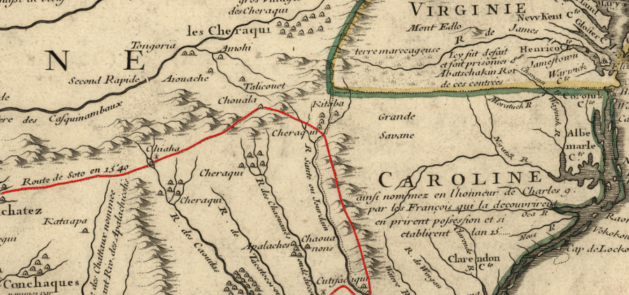
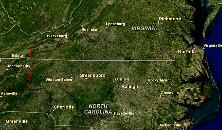
Hernando de Soto's group went much deeper into the interior of today's southeastern United States, and came close to the modern-day boundaries of Virginia. In May 1540, his explorers camped briefly at the Native American town of Xuala. That town, later known as Joara, was located near what is now the town of Morganton, North Carolina.
Hernando de Soto came close to Virginia in 1540, and 27 years later a party from the Juan Pardo expedition may have crossed what is the modern state boundary to modern-day Saltville
Map: Library of Congress, Carte de la Louisiane et du cours du Mississipi (1718)
The Spanish then turned west and headed towards Mexico. De Soto's men were the first Europeans to cross the Blue Ridge, going through the mountains at or near where the French Broad River cuts through Swannanoa Gap.
The Native Americans in the Southeast were unable to block the Spanish from traveling wherever they desired. In contrast, in what is now the Southwest of the United States the Spanish were repulsed.
Cabeza de Vaca and three others reached Mexico in 1536, and those four last survivors of the Narvaez expedition reported there were Seven Cities of Cíbola rich in precious metals and jewels. Estaban marched back into the Southwest on a 1539 trip to find them - and this time, he died there.
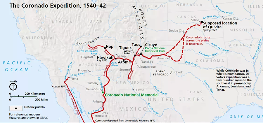
Antonio de Mendoza, Viceroy of New Spain, decided the reports justified a full expedition into the territory that the Spanish claimed north of their settlements in Mexico. In 1540 Francisco Vásquez de Coronado led the search for the Seven Cities of Cíbola. He reached the town of Quivira in Kansas in 1541 but found none of the mineral wealth that he sought. Native Americans fought the Spanish, Coronado returned to Mexico City in 1542, and Spanish settlement north of the Rio Grand was not attempted until 65 years later with the initial start of Santa Fe in 1607.5
after Native Americans successfully forced the Coronado expedition to abandon its search for the Seven Cities of Cíbola in the Southwest, the Spanish did not start to settle north of the Rio Grande for 65 years
Map: Coronado National Memorial, National Park Service, Stories
The impact of the Spanish as they travelled through Native American communities must have been dramatic. Local leaders and their followers were seized and forced to obey de Soto's commands, including serving as guides and bearers of Spanish supplies.
The Spanish had swords, armor, guns, horses, large mastiff dogs trained to maim people, and sufficient military capacity to go wherever they desired. Those who had been leaders lost status, since they clearly lacked the power to protect their followers. After the Spanish moved on to dominate another Native American community, those left behind who had survived the visit must have struggled to rebuild their society.
After the disruption of de Soto, old assumptions of authority and obligation may have been replaced by new alliances and allegiances. The political and religious patterns discovered by later English colonists may have been created with just the last 60-100 years. There was a pattern of Native American cultures and political organizations which was disrupted by the English fur traders and settlers during the 1600's and 1700's, but that particular pattern may have existed since only the mid-1500's.
The heritage and attachment to the land of the peoples who were disrupted by colonists extended back perhaps 20,000 years, but the particular patterns had changed many times since the first Paleo-Indians had arrived. Of course, the significance of the involuntary cultural change inflicted by colonists, and the dramatic population reduction and displacement of the Native Americans, is not diminished by fact that de Soto might have triggered a change in the mid-1500's.
The first Europeans to penetrate the interior of the Carolinas were not peace-loving, sensitive men. The behavior of the Spanish reflected their cultural assumptions of being "better" than the Native Americans, carrying their Catholic faith into the interior of the continent. It is unlikely that the Native Americans, forced to provide food for the Spanish and to carry their supplies, welcomed their visitors as suggested in one book about North Carolina history:6
The mountains were first explored by Europeans when a Spanish expedition under Hernando de Soto arrived in 1540. He reported the area to be pleasant and spent a month resting his horses and enjoying the hospitality of the natives.
Hernando de Soto's expedition brought Spanish goods into Native American communities, and some items must have been traded through the Piedmont into Virginia. The soldiers probably brought diseases as well, such as influenza and malaria. Those diseases can spread to other people, but would not trigger pandemics that would depopulate the region. The damage done by those diseases would have been limited to just a small number of Native Americans living near the path of the exploration party.
The Spanish men who made it to Xuala had already lived though the stage of smallpox when they could have infected others, and de Soto's expedition may not have brought pandemic-causing diseases. The soldiers were adults who had survived the killer infections, and could no longer transmit them.
possible paths of Hernando de Soto expedition through the Southeast, 1539-40 (archeological evidence now supports the blue section through central North Carolina)
Source: National Park Service, Cultural Overview, Ninety Six National Historic Site
Much later, English colonists in the Carolinas set up a slave trade to capture Native Americans. If the Spanish had not already brought depopulating diseases, the English did. Pandemics during the English colonization period killed most of the people within Native American towns.
The drastic decline of population in the Carolina Piedmont and Tennessee River watershed triggered reorganization of Native American communities, leading to formation of the Cherokee, Choctaw, Creek, Chickasaw, and other tribes. The depopulation reduced the opportunity to capture slaves locally. The difficulty of enslaving Native Americans led Carolinians to increase imports of black slaves from Africa.7
Spain dominated exploration of North America for a century. For the first six decades of the 1500's, France, England, and the Netherlands lacked the capacity to create colonies in the New World. The pressure for Spain to occupy North America was minimal.
The Spaniards focused on pillaging the native tribes in Mexico and South America of their gold and silver, sending shiploads of looted wealth back across the Atlantic Ocean. Portugal chose to focus on Brazil and the African slave trade, after dividing its claims to the New World with Spain under the Treaty of Tordesillas in 1494.
However, European rivals were able to capture Spanish ships carrying New World wealth back home even when the nations were not officially at war. To support the intercept-the-Spanish-treasure-fleet efforts, those European nations did consider establishing bases in North America. The Spanish recognized the need to establish their own North American bases to protect Spanish ships, and to block European rivals from establishing privateering/pirate bases on the Atlantic Ocean coastline.
The Spanish recognized the threat, but did not have a large enough population in the Western Hemisphere to plant settlements everywhere. The priority locations for Spanish occupation were the Caribbean islands, South America, and Mexico. Expanding to the north and planting settlements in "Florida" was a low priority for the small Spanish population. Until Central and South American nations established their independence in the 1800's, there were few peninsulares (people born in Spain) or creoles (white Spaniards born in the colonies) compared to mestizos (people with mixed European/Native American/African heritage).
After the Native Americans in Virginia eliminated the Jesuit settlement at Ajacan in 1571, there were easier opportunities with greater potential benefits. The city of Manila in the Philippines was founded in 1571, and Buenos Aires was permanently settled in 1580.8
The Spanish focused on colonizing Central/South America and the Philippines, and did not try to build bases in the latitude of Virginia far north along the Atlantic coast from the Caribbean, for three primary reasons:
the treasure fleet sailed east, away from the coast, once it had reached the 34° of latitude
supplying bases far north of the island of Hispaniola (today occupied by Haiti and the Dominican Republic) was logistically too difficult; winds and currents forced ships to sail east to Spain rather than return south to the Caribbean
Spain lacked the population to occupy North American territory that lacked obvious and easy-to-collect wealth
Spanish treasure fleets returning to Europe used the Gulf Stream to go north past Florida (perhaps as far as New York) in order to catch westerly winds across the North Atlantic, so an English colony in Virginia was a threat because it could support potential pirates
Source: Geographicus, Ocean Atlantique ou Mer du Nord (by Pierre Mortier, 1693)
The Spanish did see a need to establish a foothold on the North American continent, in the province they called Florida. Some sort of base would enhance the legitimacy of the Spanish legal claims, pre-empting other European nations from asserting that they had discovered and occupied vacant land with no Christian presence. A base on the Atlantic Ocean might also help rescue shipwrecked Spanish sailors who might manage to reach the mainland and then get Native Americans to bring them to a known Spanish outpost.
In 1557, Spanish King Philip II ordered his viceroy in Mexico to build a Gulf of Mexico base, then carve an overland path to a base on the Atlantic Ocean coastline. That base was planned to be near the site of Lucas Vasquez de Ayllon's failed settlement at San Miguel de Guadelupe. Ships from Mexico could bring a steady stream of supplies to the Gulf of Mexico base to get it started.
Ships from the Caribbean or even directly from Spain could bring people and food to the Atlantic Coast base. At some point, the two bases could be self-sufficient. An overland link would give each of them an alternative way to receive supplies without a dangerous sea voyage between them through the Florida Strait.
Spanish maps recorded latitude correctly, but they were off the mark for longitude. East-west distances were not calculated with great accuracy until a portable timekeeper was developed by the Englishman John Harrison in the 1760's. In the 1500's and 1600's, Spanish and English officials assumed the North American continent was more narrow than it really was, and that distances from the Atlantic Coast shoreline to the Ohio and Mississippi rivers were shorter than reality.
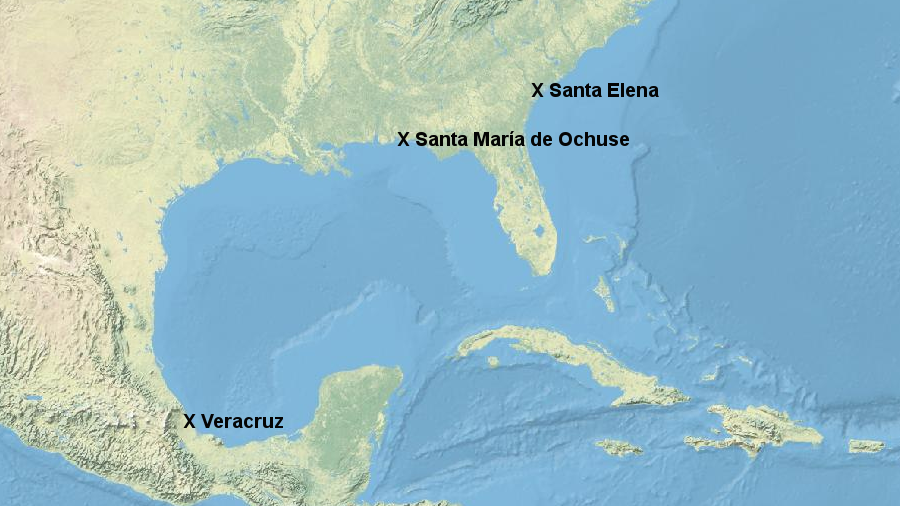
Their basic misunderstanding of longitude led Spanish officials to think they could establish an outpost somewhere on the Gulf of Mexico, send ships from Mexico to that base, and then carry supplies overland to an Atlantic Ocean base at Santa Elena (at modern Parris Island in South Carolina). Supplying an Atlantic Ocean colony via overland caravans from a Gulf Coast colony was expected to be easier than sailing from Mexico through the dangerous straights around Florida.
In 1559, the Spanish created the Santa Maria de Ochuse settlement on the Gulf Coast at what is now Pensacola, Florida. Tristan de Luna sailed from what is now called Veracruz in Mexico, with at least 550 soldiers and 200 Aztecs, to establish a colony at what we now call Pensacola Bay.
Spain planned to supply an Atlantic Coast outpost by shipping supplies from what is now Veracruz to a Gulf of Mexico base, then using a overland route to avoid sailing through the Straits of Florida
Source: ESRI, ArcGIS Online
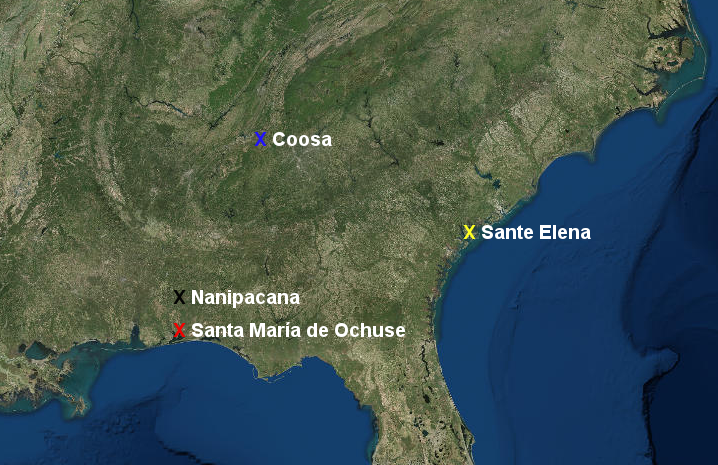
Soon after landing, a hurricane wiped out most of Tristan de Luna's ships. The Spanish were unable to supply the settlement, despite sending four major maritime relief expeditions. At one point, the remaining colonists moved inland to a Native America town of Nanipacana on the Alabama River, and sent 200 men further north to Coosa at the headwaters of that river to get supplies.
The effort was finally abandoned in 1561. Without the supply base on the Gulf of Mexico, the Spanish postponed plans to establish an outpost on the Atlantic Ocean shoreline.
In 1992, the Florida Bureau of Archaeological Research discovered one of Tristan de Luna's ships that was wrecked by the 1559 hurricane. In 2015, the site of the Santa Maria de Ochuse settlement was identified in a Pensacola subdivision.9
John Worth at the University of West Florida has detailed how the Spanish sought supplies at Nanipacana and Coosa, before abandoning Tristan de Luna's colony on the Gulf Coast in 1561
Map Source: ESRI, ArcGIS Online (based on The Tristan de Luna Expedition, 1559-1561)
The French finally triggered the Spaniards to build fortifications and settle colonists on the Atlantic Ocean coastline.
In 1562, Jean Ribault explored the St. John's River. He chose to sail north before constructing Charlesfort at Port Royal, South Carolina, near the modern Marine Corps base at Parris Island.
Ribault and most of his men returned to France, leaving behind a token force of 28 men in the fort. They became the first French colonists in North America since 1541. Their numbers were large enough to establish the French claim and protect against hostile Native Americans, but the soldiers must have known there were too few to defend the fort against any determined attack by a Spanish ship.
the arrival of the French in 1562, and their return in 1564, finally triggered the Spanish to settle on the Atlantic Coast of North America
Map Source: Jacksonville Public Library, The Story of Jean Ribault and Fort Caroline
Resupply from France was interrupted by conflict in Europe (a precursor to what would happen to English colonists left on Roanoke Island in 1587, which resulted in the "Lost Colony"). Ribault's French garrison at Charlesfort lacked both food and discipline. After the military commander exiled one soldier, which would have forced him to starve, the other soldiers mutinied. The commander was killed and the exiled soldier was rescued.
The soldiers then demonstrated great creativity by building a ship to return to Europe. When it sailed, the French abandoned Charlesfort without ever seeing the Spanish. They arrived later and burned the abandoned fort.
Sailing home to France turned out to be as dangerous as staying at Charlesfort. After running out of food on the sail home to Europe, the soldiers returning to France turned to cannibalism. They drew lots to see who would be killed for food. By chance, the person who "won" the lottery and was eaten was the one who had been rescued from starvation by the mutiny. Exploration and occupation of North America was a dangerous business...
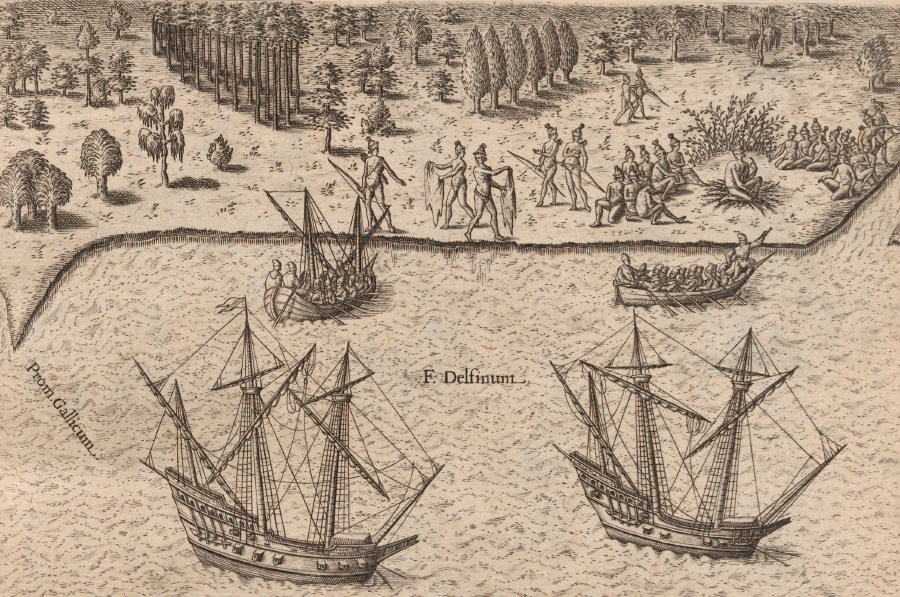
In 1564, a new French expedition returned to start a new base. This time, the effort was partly an attempt to create a refuge for Protestant Huguenots fleeing religious persecution in France.
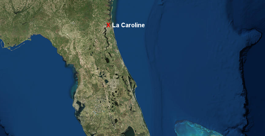
They built the settlement of La Caroline (named after King Charles IX) at a location on the St. Johns River near modern Jacksonville, Florida. The French had visited that site in 1562 before moving north to Charlesfort. The fort at La Caroline was closer to the Spanish bases in Cuba and Hispaniola than the old site at Charlesfort, increasing the risk of attack by the Spanish.10
the French built La Caroline in 1564 on the St. Johns River, near modern Jacksonville
Map Source: ESRI, ArcGIS Online
The Spaniard who responded was Pedro Menendez de Aviles. In 1565, he had obtained authority from Spanish King Philip II to govern lands in Spain's "Florida." Menendez knew from previous explorations by Panfilo de Narvaez and Hernando de Soto that North American tribes had not accumulated storehouses of gold or silver comparable to civilizations in Mexico and Peru, but there was still potential for private profit.
An additional incentive for Pedro Menendez de Aviles was that his son had disappeared in a storm near Bermuda when the treasure fleet was returning in 1561. It was possible the son's ship had struggled back to the mainland and he had survived in a Native American community awaiting rescue.
King Philip II provided little funding for the expedition initially:11
A patent, or asiento, was issued March 20, 1565, by the provisions of which Menendez was required to sail in May with ten vessels, carrying arms and supplies, and five hundred men, one hundred to be capable of cultivating the soil. He was to take provisions to maintain the whole force for a year, and was to conquer and settle Florida within three years; explore and map the coast, transport settlers, a certain number of whom were to be married; maintain twelve members of religious Orders as missionaries, besides four of the Society of Jesus; and to introduce horses, black cattle, sheep, and swine for the two or three distinct settlements he was required to found at his own expense.
The King gave only the use of the galleon "San Pelayo" and bestowed upon Menendez the title of Adelantado of Florida, a personal grant of twenty-five leagues square, with the title of Marquis, and the office of Governor and Captain-General of Florida.
After the king received reports of new French settlements in Florida, he increased royal support. Pedro Menendez de Aviles finally sailed from Cadiz on June 29, 1565 with 19 ships and 1,500 people. Sailing from Spain was a different approach than the one used in 1526 by Lucas Vasquez de Ayllon. Ayllon had sailed from Hispaniola with his 600 recruits to start the colony of San Miguel de Guadelupe back in 1526.
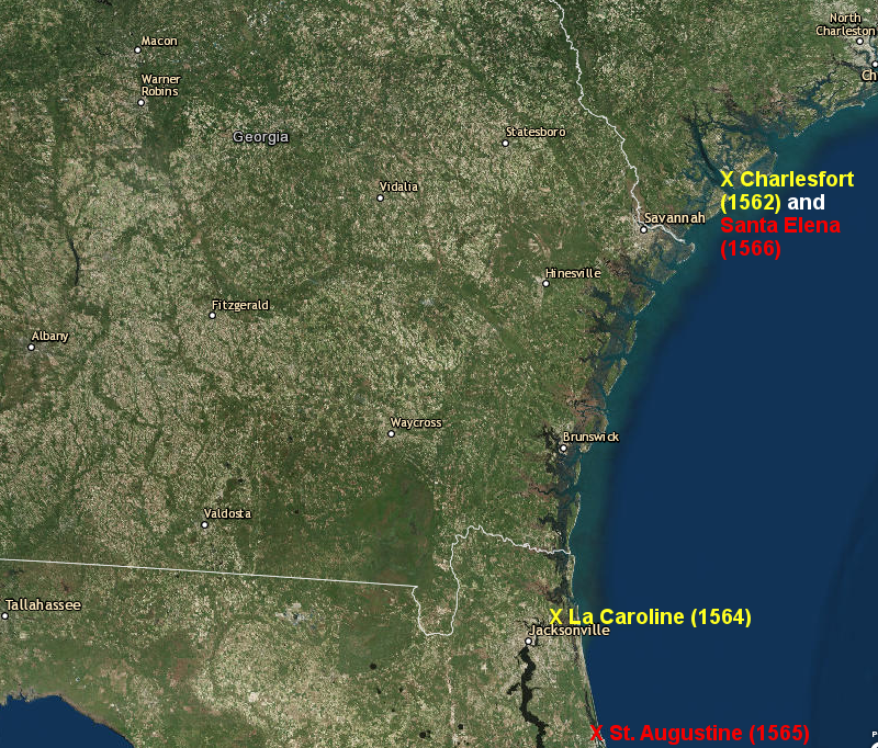
French bases at Charlesfort (1562) and La Caroline (1564) triggered the founding of St. Augustine in 1565 and Santa Elena in 1566
Map Source: ESRI, ArcGIS Online
Menendez arrived just after Ribault brought new supplies and colonists to La Caroline. To avoid the French initially, the Spanish sailed south and started to build a base on August 28, 1565 (St. Augustine's day).
The French sought to strike first at the temporary Spanish camp on the Florida coast, but the Spanish got lucky. Ribault's ships were wrecked by a storm, and the Spanish recognized that La Caroline was not protected by enough soldiers. They quickly attacked and captured La Caroline, converting it into their own Fort San Mateo.
The Spanish also discovered that the French soldiers and sailors who had tried to attack the temporary Spanish camp and had survived the storm were stranded on a beach south of St. Augustine. The French were defenseless and surrendered without a fight, but the Spanish lacked the resources to feed and guard so many prisoners. The Catholic Spanish provided little mercy to their Protestant (Huguenot) French rivals. The Spanish executed Jean Ribault and almost all of the rest of the French Protestants, at a site known ever since as Matanzas (Massacre) Inlet.12
Menendez followed up on the destruction of the French fort on the St. Johns River, and the execution of the "trespassing" Huguenots, by constructing the town of St. Augustine in 1565. St. Augustine is the oldest continuously-occupied European settlement in North America.
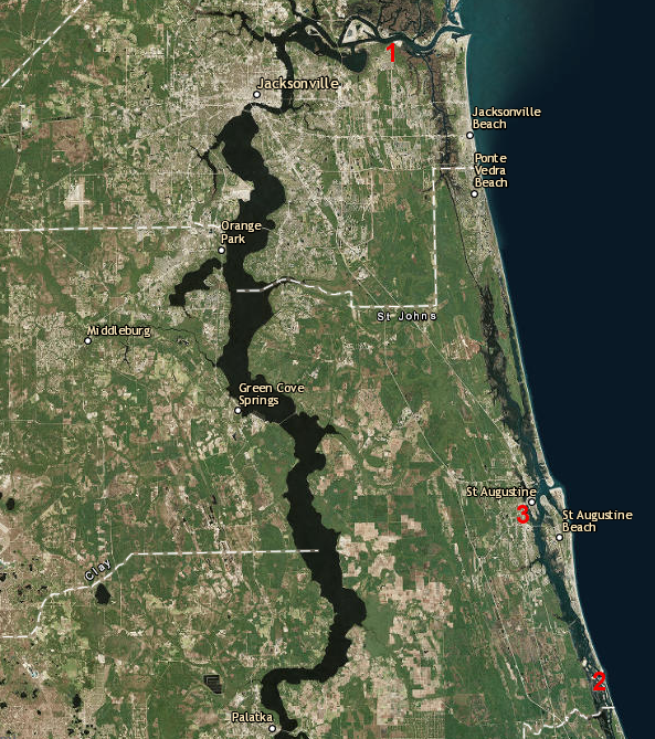
in 1565 La Caroline (1) was destroyed, the shipwrecked French were executed at Matanzas Inlet (2), and St. Augustine (3) was founded
Map Source: ESRI, ArcGIS Online
In 1566, Pedro Menendez de Aviles moved north after hearing the French were returning to Charlesfort. He built Fort San Salvador and established his second settlement at Santa Elena, at the old French Charlesfort. Today, that site is the eighth hole of the Marine Corps golf course on Parris Island.
Menendez chose to establish Santa Elena rather than St. Augustine as Spain's primary settlement on the mainland. Menendez anticipated Santa Elena would be an agricultural and trading colony generating a profit, not a military base extending Spanish control to the north. However, after the conflict with the French at La Caroline, King Phillip II of Spain sent 250 men under the leadership of Juan Pardo from Spain to Santa Elena to serve as reinforcements.13
After the unexpected arrival of more military forces, Menendez had a new and larger Fort San Felipe built at Santa Elena. However, there was not enough food for all the Spanish soldiers there.
In part to cope with the limited food supply, Juan Pardo took half of the soldiers on an exploration of the interior towards the Spanish settlements in Mexico. It was also a scouting expedition, looking for an overland road route to the silver mines at Zacatecas, Mexico. Longitude was hard to calculate before accurate portable clocks were available, and the Spanish had miscalculated the distance. They thought the silver mines were 780 miles west of Santa Elena, rather than the actual 1,800 miles.
In 1566-67, Juan Pardo led his first expedition up the Catawba-Wateree River. Starting on December 1, 1566, they began to walk. Unlike de Soto, Pardo's expedition had no horses and therefore no cavalry for fighting and intimidation.
Though Pardo was seeking a route to the west to connect to Zacatecas, he went north initially towards the Native American towns where the Spanish could obtain food by trade or force. The expedition passed by the town of Cofitachequi (near modern-day Camden) that Hernando de Soto had visited, then Otari (near modern-day Charlotte) as they crossed the Piedmont to the Blue Ridge.
At each town, the Spanish read the requerimiento, asserting their authority over the land and establishing the Catholic faith. Though he did not negotiate the claim of sovereign control, Pardo's approach to the Native Americans was less blunt that de Soto. He traded iron tools for food, and arranged for the Native Americans to build special storehouses with corn to feed the Spanish on a return trip.
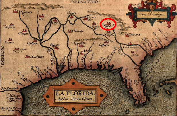
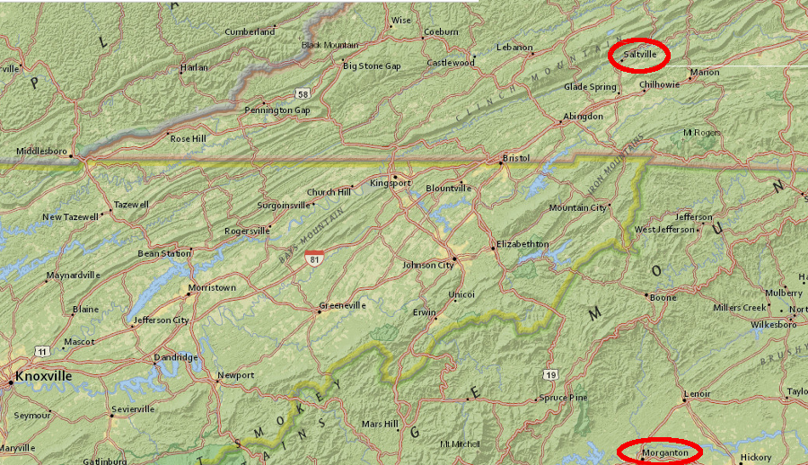
At the eastern edge of the Blue Ridge Mountains, where Interstate 40 now starts the uphill climb, Pardo established Fort San Juan. He chose the same town where de Soto had camped in 1540. In 1540, the site known to Hernando de Soto as "Xuala." In 1566, Pardo called it "Joara." The site is at modern-day Morganton, North Carolina.
Juan Pardo left 30 men at Fort San Juan, under the command of Sergeant Hernando Moyano de Morales. They planned to spend the winter of 1566-67 at Xuala/Joara. The fort gave Spain some control inland from the coast, but the major benefit was that the soldiers could live off resources not available at Santa Elena.
Pardo and the almost all of the rest of the Spanish force returned via the Catawba River and the town of Guatari, reaching Santa Elena on March 7, 1567. Pardo expected to make Guatari part of the 5,500-square-mile domain that he had been promised for his service in North America. The town of Guatari was a trading center at a ford crossing the Yadkin River. The site is seven miles northeast of modern Salisbury near I-85, and now submerged beneath High Rock Lake.
Pardo set out again on September 1, 1567, leaving with 120 soldiers from Santa Elena to find the inland route to the silver mines at Zacatecas. He revisited Guatari and got cooperation from the Native Americans, who built a fort using poles with dirt packed between them. The Native Americans were accustomed to building wattle and daub structures for their own homes. Pardo left 16 soldiers at Fort Santiago under the command of a corporal, and renamed the community to be Salamanca.
On January 7, 1568, Pardo left with 63 soldiers. When he reached Xuala/Jaora, he discovered Hernando Moyano de Morales and the rest of the Spanish soldiers he had left behind were no longer there. Moyano had taken them further west.14
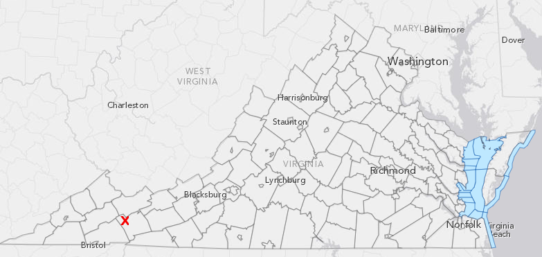
the first Spanish to see Virginia were sailors, but the first to explore inland may have been the soldiers with Hernando Moyano who attacked Maniateque, near modern Saltville (red X) in Smyth County
Map Source: ESRI, ArcGIS online (with Virginia_DCR_2004_Boundaries - Virginia DCR 2004)
In his efforts to maintain the support of the Native Americans at Fort San Juan (Xuala/Joara), Moyano became ensnared in local disputes between different Native American groups. He took 20 soldiers north, perhaps crossing into what is now Virginia, and attacked the Chiscas tribe's town of Maniateque. That town may have been near modern Saltville in Smyth County.
in 1567, Hernando Moyano led a foray from Fort San Juan near modern Morganton to destroy a Chiscas community that may have been near modern Saltville
Map: ESRI, ArcGIS Online
As a result of that expedition to Maniateque, it is possible that the first Europeans to enter Virginia were members of that 1567 expedition led by Hernando Moyano - not counting the occasional sailors who had previously stopped along the shoreline in search of fresh water, food, information, slaves, loot, and female companionship.
Spanish soldiers led by Hernando Moyano may have attacked a Native American town in Virginia in 1567
Source: ESRI, ArcGIS Online
Moyano was not reluctant to use force. After the attack on Maniateque he received a threat from a Chisca chief. In response, Moyano took all his men across the Blue Ridge into what is now Tennessee and attacked a Chisca town. According to the Tennessee Encyclopedia:15
Moyano then explored the Upper Tennessee Valley for four days for precious metals and gems before arriving at the palisaded main town of Chiaha on Zimmerman's Island in the French Broad River near present-day Dandridge, Tennessee. This town had been visited previously by the Hernando de Soto and Tristan de Luna expeditions. While at Chiaha, Moyano’s men were well fed and well treated. Moyano explored the area around Chiaha and built a small fort on the island.
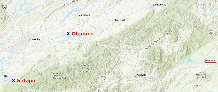
After Pardo reached Xuala/Joara the second time and discovered that Moyano had moved west, he took his force down the French Broad River and reunited with Moyano at the town of Olamico. All of the Spanish then headed south towards the Great Smoky Mountains. While at the town of Satapo, Pardo was warned of a planned ambush. All the Spanish returned to Olamico and then walked back to Santa Elena, building two more forts along the way. They expedition returned to Santa Elena on March 2, 1568.16
Juan Pardo led Spanish soldiers to reunite with Hernando Moyano at Olamico, then returned back to Sante Elena after being warned at Satapo of a planned ambush
Source: ESRI, ArcGIS Online
Europeans would not gain a clear understanding of territory that far inland far from the Chesapeake Bay for another 150 years, when explorers such as Dr. Thomas Walker mapped a route through the mountains at Cumberland Gap. The inland forts of the Spanish were all destroyed within a year under pressure from local Native Americans.
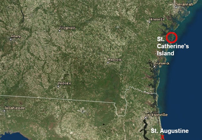
In 1568, Jesuits established Mission Santa Catalina de Guale on St. Catherine's Island. Jesuits also traveled to the Chesapeake Bay in 1570 and attempted to start the Ajacan settlement on the edge of the York River.
The Jesuits in Virginia were killed in 1571, and the other Jesuits in the southeast were replaced by Franciscan friars in the 1570's. The Franciscans were more successful in starting missions in Native American communities, spreading the Catholic faith and Spanish culture. Unlike the Jesuits, they never attempted to start a mission as far north as Ajacan.
The initial Franciscan focus was on converting and acculturating the Muskogee-speaking Guale who lived north of St. Augustine. Spanish soldiers lived in the mission towns, providing protection but also demonstrating selfish behavior that interfered with the efforts of the friars. The Spaniards did not enslave the residents near the missions, but as part of the "repartimiento" labor system they demanded some free labor each year.17
Jesuit and then Franciscan friars maintained a settlement on St. Catherine's Island
Source: ESRI, ArcGIS Online
The Spanish retained control of the seacoast at Santa Elena until 1576. Menendez died in 1574, and his sons-in-law took control but were unwilling to cooperate in managing the colony. The local Native Americans attacked and, after the Spanish retreated to St. Augustine, destroyed the town of Santa Elena and Fort San Felipe. A new governor of Florida replaced Menendez's sons-in-law and returned with soldiers in 1577. He built yet another fort there, Fort San Marcos.
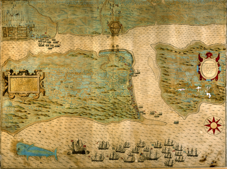
Sir Francis Drake raided the Spanish settlements in the Caribbean as a privateer in 1586. His last attack was the burning of St. Augustine, after which he sailed to the English colony to Roanoke Island and took nearly all the colonists back to England. Sir Richard Greenville arrived at Roanoke Island soon afterwards and left 15 men to maintain an English possession near the Spanish in Florida. All 15 had disappeared when the next set of colonists (ultimately the "Lost Colony") arrived in 1587.
English privateers destroyed the town of St. Augustine in 1586, then visited the Roanoke Colony and took nearly everyone home to England
Source: Florida Memory, Saint Augustine Map (by Baptista Boazio, 1589)
After Sir Francis Drake burned St. Augustine in 1586, the Spanish decided to contract their defense perimeter. They abandoned Santa Elena, burned Fort San Marcos, and retreated to St. Augustine.
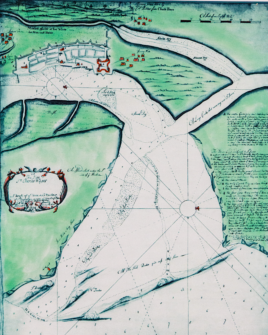
St. Augustine was a weak Spanish outpost until the 1670's. Pirates successfully raided the town in 1668, surprising the residents at night. The soldiers retreated to the decaying wooden fort, while 60 residents who were unable to flee in time into the woods were killed.
Because the pirates did not burn the town, and because they carefully measured water depths to document the location of the deepest channel, the Spanish anticipated that the pirates planned to seize St. Augustine and convert it into a base for raids on the treasure fleet and other shipping. That triggered the construction of a strong fort, Castillo de San Marcos, in the 1670's.
St. Augustine, settled 42 years before Jamestown was started in Virginia, remains as the oldest continuously-occupied European place in North America.18
a pirate raid in 1668 finally forced the Spanish to build a strong fort to protect St. Augustine
Source: National Park Service, 1732 British Spy Map of St. Augustine
Though the Spanish governors concentrated military forces at St. Augustine, the Catholic missionaries continued their efforts to convert the local Native Americans. After more friars arrived in 1587, the Franciscans opened a mission on Cumberland Island in the capital town of the Timucua-speaking Mocama.
The Native American population was dramatically reduced by disease, by the demands for work and food, and by cultural disruption. The Guale finally rebelled in 1597, and the Spanish abandoned the missions north of St. Augustine until 1604.
The inland missions, where supply from Spanish ships was not possible, were the hardest to maintain. After Charles Town was settled in 1670, English traders began to connect with various Native American groups on the coast and inland. The Yamasee in particular cooperated with the English, after being forced north by the Guale. The English promoted raids to capture slaves from the Guale and others associated with Spanish missions, and sent the Native American captives to Caribbean islands.
The zone south of Charles Town became unsafe, and Spanish missions were consolidated on the seacoast islands after 1684. By 1706, raids of the English and their Native American allies forced the Spanish into just St. Augustine. The Yamasee rebelled against the South Carolina colonists in 1715, but the Spanish did not try to expand north of St. Augustine during or after the Yamasee War.19
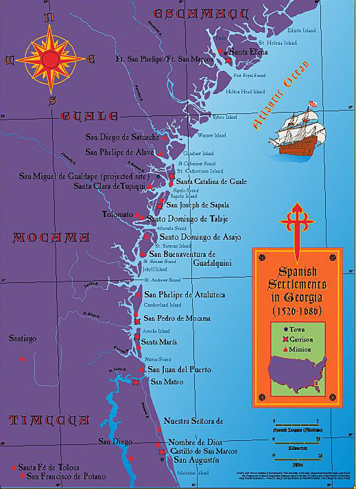
Franciscan friars established missions north of St. Augustine, prior to the English charter for Georgia in 1732
Map: Georgia Info, 1526-1686 Spanish Missions in Georgia Map
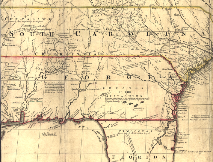
Spanish reluctance to block English encroachment stands in contract to French assertiveness 50 years later and further north.
The French moved south from the St. Lawrence River valley, while the English expanded westward into the Ohio River backcountry. That rivalry also involved multiple Native American groups, and led to open warfare between France and England. The French and Indian War in North America then expanded to become the Seven Years War in Europe, finally concluding in 1763.
In that conflict, France ended up losing all of its territory in mainland North America, key sugar-producing islands in the Caribbean, and some authority in India. Spain's caution did not produce a better result. In the end, like France, Spain was forced to cede its land claims in North America to the English and ultimately to the American settlers.
Spain's opportunity to stop the English from occupying the East Coast, within the boundaries of "Florida," faded in the 1600's. After the failure of the Spanish Armada in 1588, England's economic and military capacity increased as Spain's decreased.
The colony of Georgia was chartered in 1733. Colonists built Fort Frederica in 1736, extending England's claims further south.
The War of Jenkins' Ear started in 1739, and was a precursor to the War of the Austrian Succession in Europe. During that conflict, there was direct fighting between Spanish and colonial forces in North America. The Georgia militia attacked St. Augustine in 1740, but failed to capture it when Spanish supply ships avoided the Royal Navy blockade.
Spanish officials then launched an invasion into Georgia in 1742. They were defeated near St. Simon's Island, at site since named Bloody Marsh, and never got near Savannah. Until 1763, Spanish and colonial aggression was conducted mostly through proxies, as each side recruited Native American allies to attack the other.
Spanish claims to the remainder of Florida were a casualty of the French and Indian War. Spain sided with France, and Great Britain captured Havana. In the 1763 Treaty of Paris, Spain traded Florida in exchange for regaining Cuba. Spain then focused on expanding its control on the western edge of North America, starting with Franciscans founding a mission at San Diego in 1769. Military troops and priests sought to alter the culture and faith of the Native Americans in the Southwest:20
Over 54 years, four forts, or presidios, and twenty-one missions were founded along the California coast. Some of these sites eventually evolved into the state's major cities, including San Diego, Santa Barbara, San Jose and San Francisco.
In 1784, Great Britain returned Florida to Spain, after losing the war with American rebels. Spain had allied with the United States in the American Revolution, and the new nation wanted militarily-weak Spain to control the land on its southern frontier. Militarily, Great Britain was more powerful; politically, Great Britain was a greater threat.
At the end of the American Revolution, the United States was a greater threat to Spain than Spain was to the United States. Leaders throughout the newly-independent country expected settlements to expand southward, and eventually the country would obtain control of Florida. Many had the same expectation of the Spanish lands west of the Mississippi River. France had transferred control over Louisiana to Spain in 1762, compensating it for losses in the French and Indian War.
Napoleon reclaimed and sold the territory to Thomas Jefferson's negotiators in 1803. The boundaries of the territory were not clear, including where the French control ended east of New Orleans and Spanish Florida began. The Americans claimed West Florida was included as part of the Louisiana Purchase. Since 1784, Spain had relied upon the Creeks and other Native American allies to contest the gradual occupation of that land by American settlers.
The Americans objected to the Spanish policy of granting freedom to slaves who escaped to Florida. That practice started in 1687 after the Spanish had authorized creation of Gracia Real de Santa Teresa de Mose, the first town in North America controlled by free blacks. Enslaved people from Virginia, as well as other colonies, fled to Florida.21
Andrew Jackson invaded Spanish-controlled East Florida in the First Seminole War. He captured Pensacola in 1818, but was directed to withdraw so a political resolution could be negotiated with Spain. The Adams-Onis treaty, signed in 1819 and ratified in 1821, ended Spain's long efforts to control land on the East Coast of the United States in return for American recognition of Spanish claims to Texas.
Spanish control over its colonies in Central and South America dissolved, and new nations declared their independence. President James Monroe issued a statement in 1823, since known as the Monroe Doctrine, to deter Spain or other European nations from interfering with the independence of the new nations.22
as the Spanish Empire dissolved and independent states emerged, President James Monroe announced the Monroe Doctrine in his 1823 message to Congress
Source: Architect of the Capitol, The Monroe Doctrine, 1823
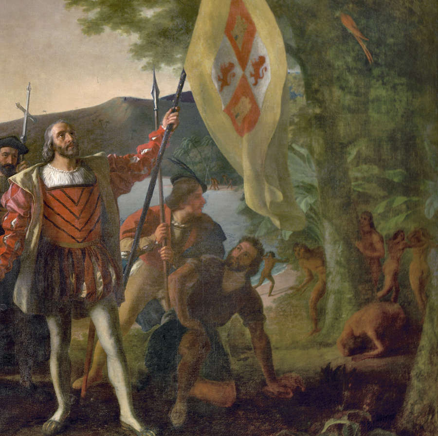
King John II of Portugal declined to support Columbus' planned expedition to Southeast Asia, but King Ferdinand and Queen Isabella in Spain funded his 1492 trip - so the first Europeans to settle in the New World were Spanish
Source: Architect of the Capitol, Landing of Columbus