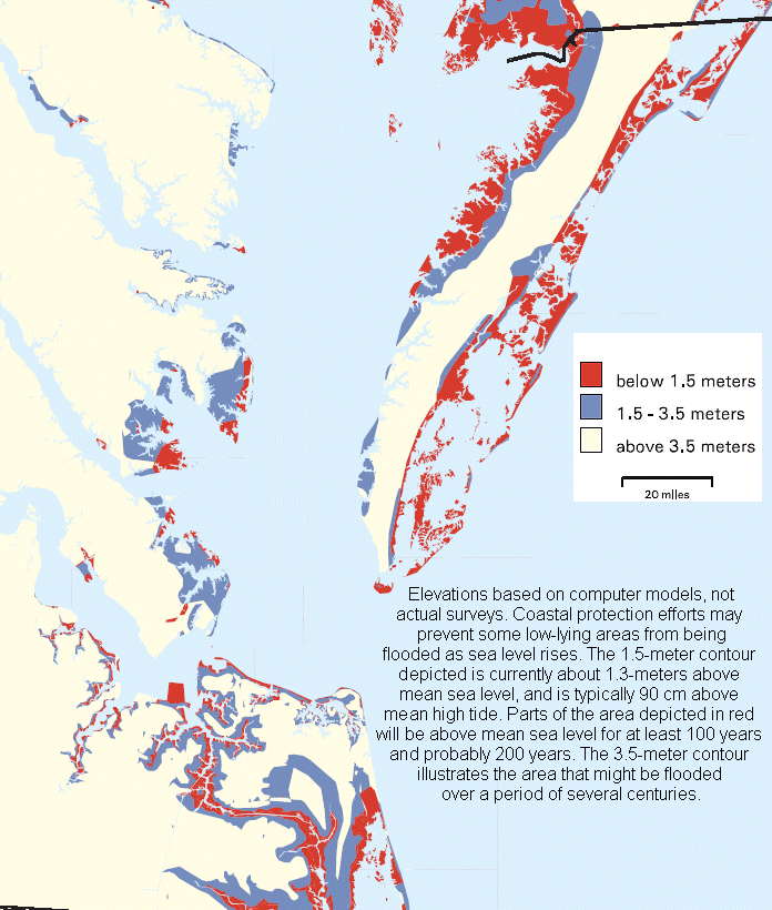
What will flood in Virginia if sea level rises 5-10 feet, or more...
Source: Environmental Protection Agency, Maps of Lands Vulnerable to Sea Level Rise: Modeled Elevations Along the U.S. Atlantic and Gulf Coasts
What will flood in Virginia if sea level rises 5-10 feet, or more...
Source: Environmental Protection Agency, Maps of Lands Vulnerable to Sea Level Rise: Modeled Elevations Along the U.S. Atlantic and Gulf Coasts
Sea levels have climbed and dropped since continents first formed. Changes in sea level have affected the climate, and changes in climate have affected the sea level.
Since multicellular forms of life evolved, new shorelines and new habitats have shaped evolutionary changes. The highest sea levels in the last 500 million years occurred 117 million years ago.
Sea levels were 700 feet higher compared to today during that time in the Cretaceous Period, when dinosaurs were wandering around Virginia but before Tyrannosaurus rex evolved west of the Cretaceous Seaway. The Atlantic Ocean, forming as the supercontinent Pangea split up, was shallow. Relatively high sea levels covered 30% of the land that is now dry.
Sea level 135,000 years ago were approximately at today's level. Water was then trapped in continental ice sheets until the Last Glacial Maximum was reached about 20,000 years ago. At the time, sea level was 400 feet lower than today.
For the next 6,000 years, gradual global warming led to a 60-70 foot rise in sea level. A pulse of melt water created a rapid rise for 1,000 years that could have been as fast as 53 mm/year. During the Younger Dryas period of global cooling around 12,900-11,800 years ago BP (Before Present), the rate of sea level rise slowed substantially. A second melt water pulse 8,200 years ago created another period of rapid sea level rise. Gradual melting of ice sheets followed, and sea levels stabilized about 6,000-7,000 years ago.1
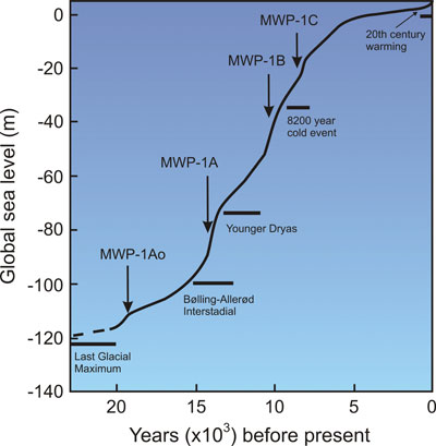
after the Last Glacial Maximum, sea level rise included irregular melt water pulses
Source: National Aeronautics and Space Administration, The Great Ice Meltdown and Rising Seas: Lessons for Tomorrow
If the earth warms at rates predicted by some studies, the oceans will rise for two main reasons - the expansion of the existing water as it heats, and the addition of additional water as the ice melts off the land at Antarctica. Since 1955, 90% of the extra heat trapped by greenhouse gases has been absorbed by the oceans.
A study in 2021 concluded that the temperature of the Chesapeake Bay had risen about 2°F since the mid-1980's. Since 1900, average temperatures have climbed globally by 1.8°F, half of the 3.6F (2°C) threshold set by the 2015 Paris accord.
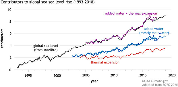
sea level is rising in part because extra trapped heat creates thermal expansion of the oceans, increasing the volume
Source: National Oceanic and Atmospheric Administration, Climate Change: Global Sea Level
If all the ice now on Greenland melted, sea level would rise 23 feet. Total melting of the Antarctic Ice Sheet would trigger a 200 foot rise. Just 400,000 years ago, much of the Greenland ice sheet had vanished due to natural climate fluctuations. The carbon dioxide in the atmosphere in 2022, 419 parts per million (ppm) are 1.5 times higher than when much of Greenland was ice-free.
The Greenland ice sheet is a feature that appears and disappears. About 55 million years ago, CO2 levels were around 1600ppm and Greenland was ice-free. CO2 levels have been lower than the current level over the last 16 million years The ice ages started when CO2 levels dropped below 270ppm 2.6 million years ago. Back in 1750 at the start of the Industrial Revolution, CO2 levels were 280 parts per million (ppm). By 1900 the concentration had increased to 300ppm and now is climbing past 420ppm.
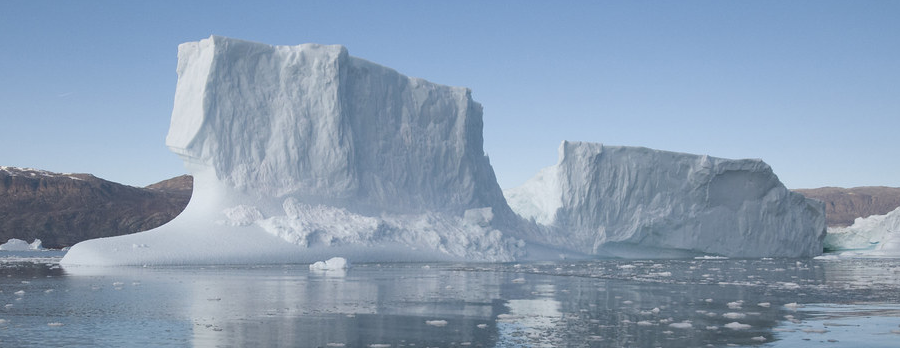
melting of the Antarctic ice sheet would cause sea levels to rise 10 times more than melting of the Greenland ice sheet
Source: GRID-Arendal, Iceberg Rødfjord, Northeast Greenland National Park
Sea level rise will affect primarily the eastern edge of Virginia, while changes in rainfall/temperature will affect the entire state. On the western side, scientists are monitoring two species that grow on rock outcrops in Shenandoah National Park, three-toothed cinquefoil (Sibbaldiopsis tridentata) and Appalachian fir clubmoss (Huperzia appalachiana). Virginia's mountains are at the edge of the current range for those species, so increased temperatures could cause them to disappear from Virginia.
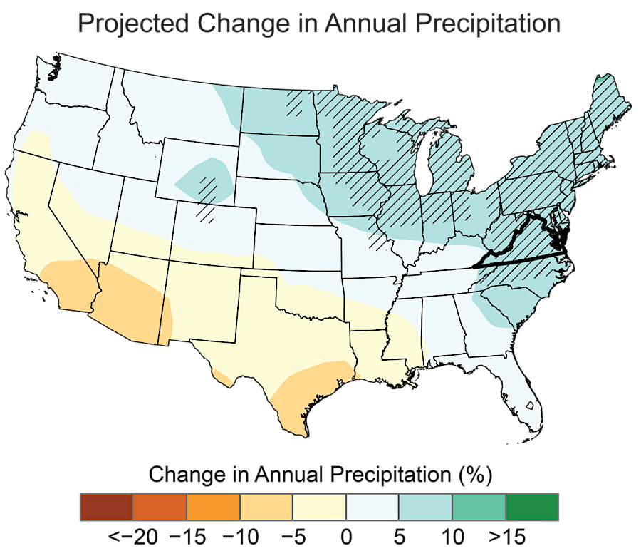
by the end of the century, precipitation in Virginia could increase by 10%
Source: National Oceanic and Atmospheric Administration (NOAA), State Climate Summaries 2022 - Virginia (Figure 6)
The marshes along the Eastern Shore are disappearing as sea level rises. By 2025, the population of laughing gulls was declining. The director of the Center for Conservation Biology at the College of William and Mary was succinct in describing the impact of sea level rise on the most abundant seabird in the state:2
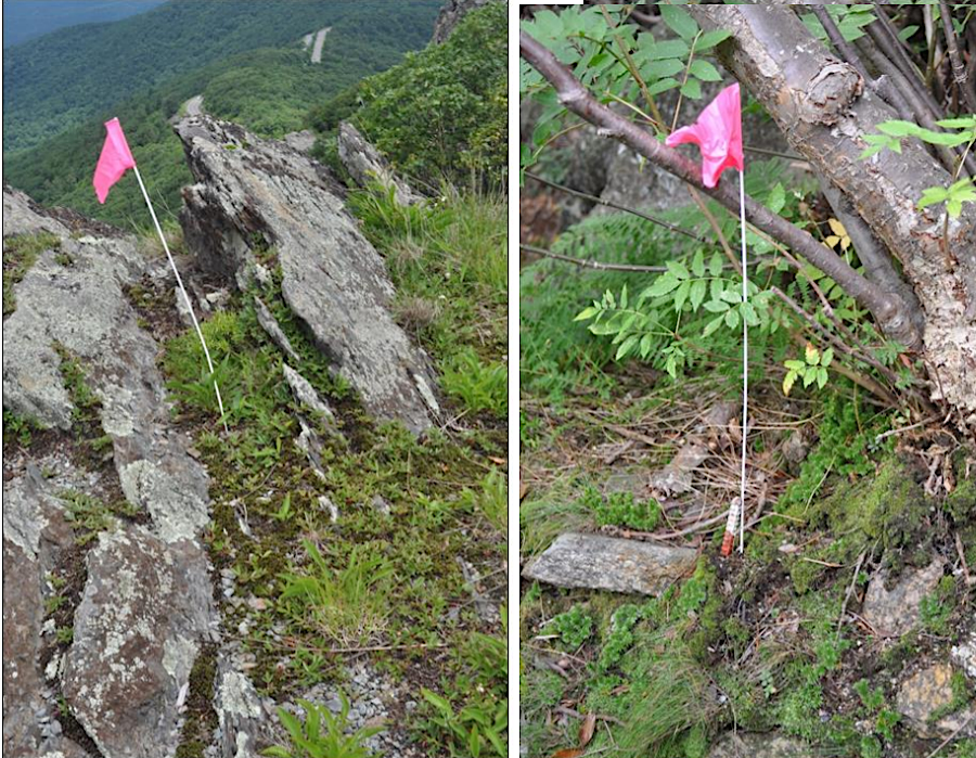
Shenandoah National Park is monitoring the ability of three-toothed cinquefoil and Appalachian fir clubmoss to cope with climate change
Source: National Park Service, Photo Monitoring of High-Elevation Plants in Shenandoah National Park (Figure 4)
Predictions about global warming by 2080 if emissions of greenhouse gases are not constrained suggest that Virginia cities will experience temperatures now common in Texas and Alabama. Species adapted to Virginia's current climate may disappear, especially if they are at the southern end of their habitat range. Warming temperatures could cause red spruce, brook trout, yellow birch, northern red oak, eastern hemlock, white pine, and the wood frog to disappear from the state.
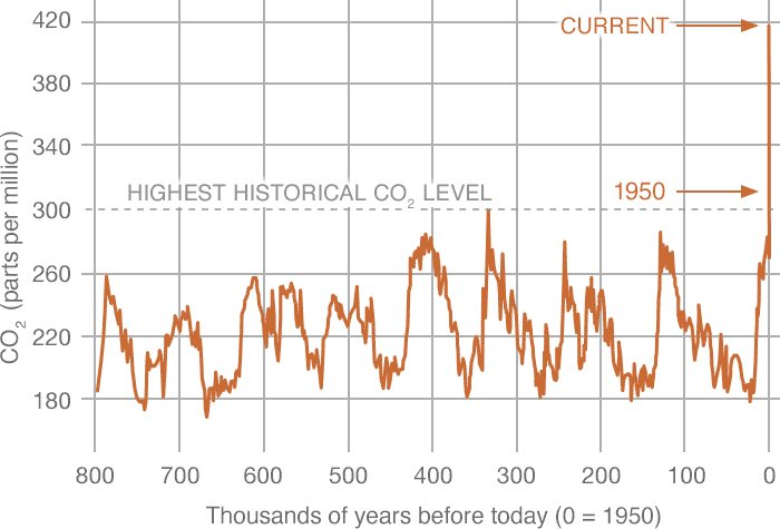
the rapid increase in the level of carbon dioxide in the atmosphere is trapping heat, warming the oceans, and triggering rapid climate change
Source: National Aeronautics and Space Administration (NASA), Carbon Dioxide
Populations of species now near the northern limit of their range, including the oak toad, Cope's gray treefrog, Spanish moss, and the bald cypress, may increase within Virginia as temperatures and rainfall increase. The speed of global warming will enable species that adapt quickly to expand their ranges into new habitats. The populations and range of slow-to-adapt species will be reduced. Some species will go extinct faster than would normally occur.
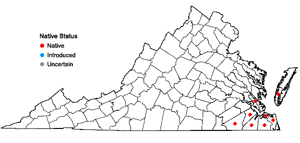

a warmer climate will allow Spanish moss (Tillandsia usneoides) to expand its current range further north towards the Maryland border
Source: Digital Atlas of the Flora of Virginia, Tillandsia usneoides (L.) L
Agricultural operations as well as native plants are being affected by changing temperatures and rainfall patterns. The 2023 update to the US Department of Agriculture's Plant Hardiness Zone Map, based on average annual extreme minimum winter temperature, reflected a 2.5°F increase in average temperatures. That caused many areas to move into a warmer "half zone" that is 5°F warmer.
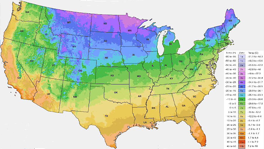
warming temperatures are altering the number of frost-free days and average annual extreme minimum winter temperature
Source: US Department of Agriculture (USDA), 2023 USDA Plant Hardiness Zone Map
Adaptation to changing habitats is a normal process. Species ranging from mastodons to mallard ducks occupied new territory as the ice sheet withdrew from Pennsylvania 18,000 years ago.3
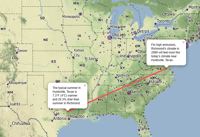
Virginia cities in 2080 will experience temperatures and rainfall currently common much further south
Source: University of Maryland, What will climate feel like in 60 years?
The very first Native American dwelling sites located along the edge of Atlantic Ocean 15,000-20,000 years ago were drowned long ago, and are now underneath 400 feet of water. More recent occupation sites along the shorelines of the Chesapeake Bay and its tributaries are now disappearing as sea levels continue to rise. Erosion from the rising waters has washed away irreplaceable archeological resources that were once on dry land.
The Threatened Sites Grant Program of the Virginia Department of Historic Resources (DHR) has funded projects for both site protection and documentation along changing shorelines. In 2023, the state agency awarded a grant for "Evaluation and Analysis of a Shell Midden in the Poropotank River, King & Queen County:"4
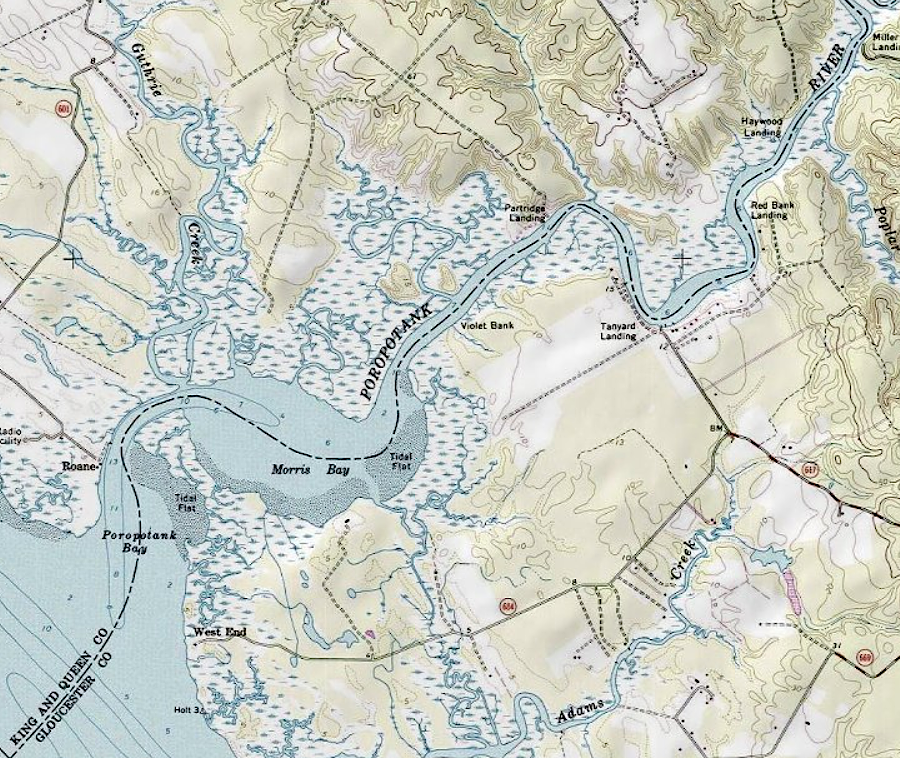
a Middle Woodland shell midden (Site 44KQ0176) in the Poropotank River is disappearing due to sea level rise
Source: ESRI, ArcGIS Online
Sea level is rising at nearly an inch a century now on the Atlantic Ocean coastline of Virginia. Water levels are rising as glaciers and ice on Antarctica/Greenland melt, as the oceans get warmer they swell up. In addition, the land along Virginia's Atlantic Ocean shoreline is dropping, as the edge of the continent adjust to the loss of the heavy ice sheet that melted away 18,000 years ago.
The land once buried by the ice sheet is rebounding upward, since the heavy weight of the ice has disappeared. The eastern edge of Virginia had been warped upwards in a "forebulge" when the ice depressed the middle of what is now Pennsylvania. The same isostatic adjustment causing Pennsylvania to rebound upwards now is causing the eastern edge of Virginia to gradually sink (subside) downwards.
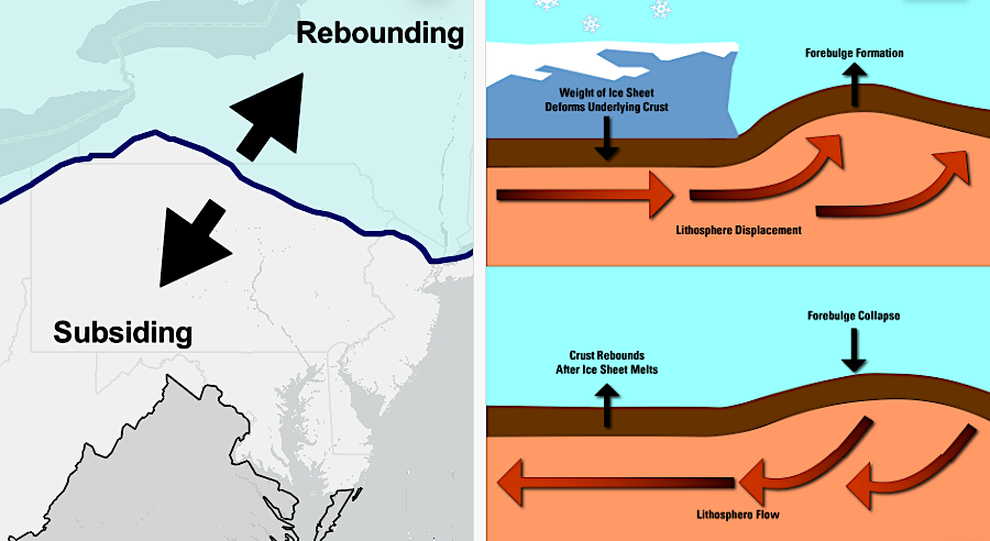
sea level is rising in part because the eastern edge of Virginia is sinking (subsiding) after the ice sheet has retreated
Source: US Geological Survey (USGS), Land Motion and Subsidence on the Virginia Coastal Plain
Research published in 2024 by Virginia Tech and US Geological Survey scientists using interferometric synthetic aperture radar (InSAR) quantified that subsidence rates of 2mm per year on the Atlantic Ocean coastline would impact 867,000 properties and over 2,000,000 people. Glacial isostatic adjustment (GIA) accounted for over half of the subsidence at cities near the shoreline such as Norfolk; the remainder was caused primarily by groundwater extraction and sediment compaction.
Norfolk (with 42,000 people and 95,000 properties) and Virginia Beach (with 451,000 people and 177,000 properties) are sinking at 2mm per year. The Delmarva Peninsula is sinking at a rate of 5mm per year. Over 75% of the transportation infrastructure, including interstate highways, is at risk.5
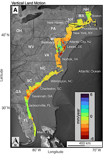
subsidence is greatest near the Chesapeake Bay
Source: PNAS Nexus, Slowly but surely: Exposure of communities and infrastructure to subsidence on the US east coast
In 2022, the National Oceanic and Atmospheric Administration (NOAA) predicted that by 2050, sea level in Hampton Roads would rise by 15-18 inches. That increase was projected no matter how current greenhouse gas emissions might be reduced. Previous emissions plus continued land subsidence would result in changing water levels. Higher water would threaten waterfront roads and housing across Hampton Roads by 2050, with intermittent nuisance flooding at "King Tides" becoming a common occurrence in low-lying areas.
If the rise continued at the predicted rate, Jamestown Island will be underwater in 2107 during the 500th anniversary of the arrival of English colonists. By 2050, Naval Station Norfolk could experience minor floods every week and one major flood a year; federal facilities worth at least $387 billion could be affected nationwide. In a thousand years all of the Eastern Shore, Virginia Beach, Norfolk, Chesapeake, and Suffolk could be underwater or become offshore sandbars.
Since Europeans began mapping the Chesapeake Bay, over 500 islands have disappeared. By the end of the 1800's, news stories noted how the islands were washing away. Holland Island in Maryland had over 350 residents in 1910, living on 160 acres. The last house remaining, which had been built in 1888, collapsed in 2010 as the remnants of the island washed away.
Sea level rise has not been steady for centuries. It increased significantly around 1850, as the Industrial Revolution increased emissions of greenhouse gases and spurred warmer sea temperatures. On average, the edge of marsh and forest is moving 1.6 feet inland each year in the Chesapeake Bay. Saltwater is poisoning the roots of the trees, killing them and creating "ghost forests."
Today sea level is rising faster than wetlands can migrate inland. One result is that the wetlands are sequestering carbon at a higher rate. Organic material is being buried, and carbon concentrations in the sediments are substantially higher than in the past.6
However, the Virginia Coastal Resilience Master Plan completed in 2021 concluded that by 2080:7
Rural shoreline communities on the Eastern Shore, Northern Neck, Middle Peninsula, and Hampton Roads are particularly at risk. Roads that currently flood intermittently will be covered more regularly, isolating houses during "blue sky" floods as well as storm events. Septic systems installed when groundwater levels were lower will fail in saturated soils, causing raw sewage to migrate into nearby creeks and rivers.8
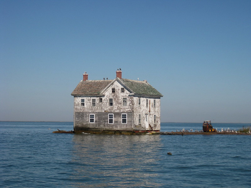
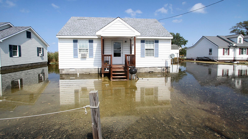
the last house on Maryland's Holland Island, built in 1888, washed away in 2010
Source: Flickr, Water front home for sail (by baldeaglebluff, October 21, 2009)
Costs of private insurance reflect the perceived risks of damage during a major storm. Costs for flood damage insurance, which is covered by a Federally-controlled program, started to skyrocket in the 2020's. Insurance costs will continue to rise, driving new development inland, long before buildings in Norfolk are recycled as oyster reefs or fish swim through the windows.
Insurance companies are choosing not to renew existing homeowner policies, forcing customers to pay higher rates from the companies that remain in the business. The highest rate of non-renewal in 2024, 1 in 25 policies, was in Accomack County where shoreline properties were at high risk from storm surge and hurricane winds. The non-renewal rate had climbed 400% since 2018.9
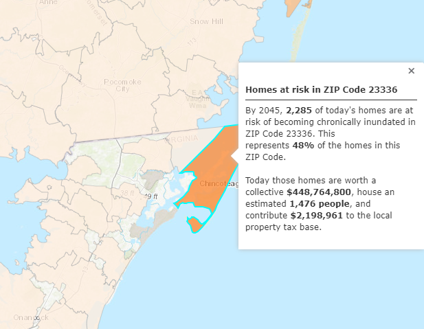
the Union of Concerned Scientists predicts nearly half of homes at Chincoteague will be flooded regularly by 2045
Source: Union of Concerned Scientists, US Coastal Property at Risk from Rising Seas
Seawalls and bulkheads can armor the shoreline temporarily. At some point, only retreat from the rising water will be cost-effective. Civic leaders who champion new development in Norfolk and Virginia Beach, such as the Tide light rail system, will be forced to consider the option of moving infrastructure further inland.
Even the dead in Norfolk are threatened. The Riverside Memorial Park cemetery is a high spot, topographically, in the city bt the riverbanks are being undercut by erosion. In 2022, 10 headstones and the grave contents were at risk of washing down the slope into the Eastern Branch of the Elizabeth River. The city estimated it would cost $2 million to repair 1,500 feet of shoreline.10
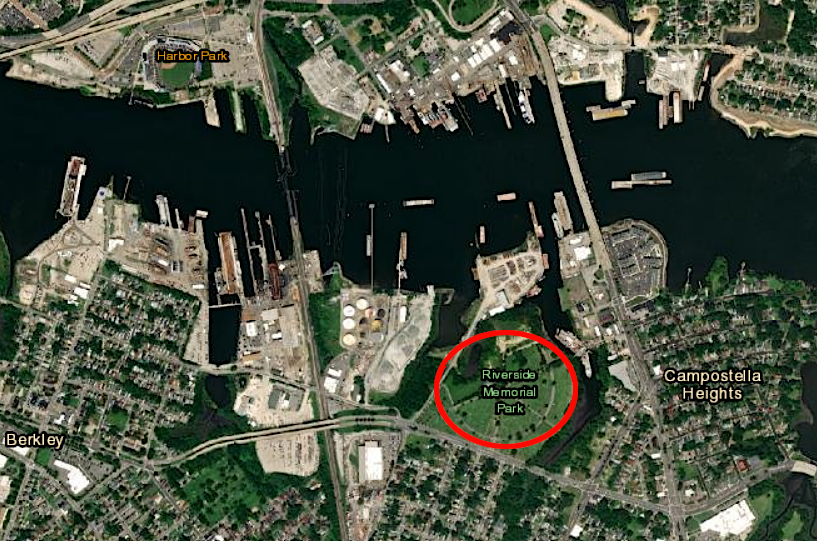
rising sea level threatened to erode the shoreline at Riverside Memorial Park in Norfolk, and spill graves into the Eastern Branch of the Elizabeth River
Source: ESRI, ArcGIS Online
A Category 1 hurricane can create a disaster now. On September 6, 2019, Hurricane Dorian sent a seven-foot high storm surge from Pamlico Sound over Ocracoke Island in North Carolina. Nearly every building experienced flood damage, and after another winter storm damaged NC 12 the island could not reopen for tourists until December 2.
As residents assessed how many more storms their tourism-based economy could survive before government agencies stopped financing recovery and rebuilding efforts, a county commissioner commented:11
in Prince William County, houses on Bay Street east of Veterans Park are at risk if sea level rises four feet
Source: Citizens Climate Lobby, Surging Seas Risk Zone Map
Even if greenhouse gas missions are reduced, mitigation and adaptation will be required. Sea level rise will impact communities on the Eastern Shore such as Chincoteague and Tangier Island, making then uninhabitable within several decades. Sea walls and elevating the islands are technically feasible, but dramatically expensive solutions.
The highest elevation on Tangier Island was just six feet above sea level in 2023. The population shrank by 40% between 2010-2020, so the per capita costs of mitigation solutions were increased. There were only 42 students in the K-12 Tangier Combined School in 2023 and just four high school graduates that year.
One Tangier resident noted:12
A biologist with the US Army Corps of Engineers calculated the cost of raising Tangier Island an additional 10 feet would be $250-$350 million, and commented:13
Tangier Island yards once flooded only by hurricanes now are covered regularly by some high tides
Source: US Amy Corps of Engineers, 160916-OI229-A-020
In Virginia, 48% of energy-related CO emissions in 2017 were generated by the transportation sector, primarily from cars, trucks, trains, and airplanes.14

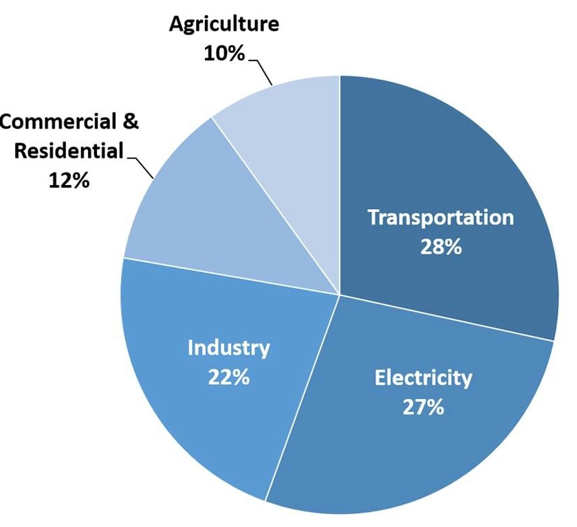
in 2017, the largest sector of the economy generating carbon dioxide was transportation
Source: US Energy Information Administration, 2017 State energy-related carbon dioxide emissions by sector
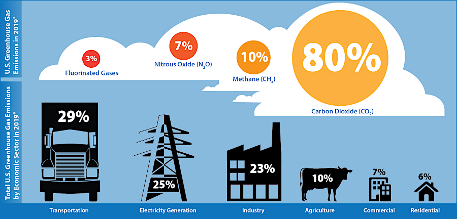
the Environmental Protection Agency calculated the transportation sector generated less than one-third of total greenhouse gas emissions in 2019
Source: Environmental Protection Agency (EPA), Inventory of U.S. Greenhouse Gas Emissions and Sinks and Greenhouse Gas Inventory Data Explorer
Natural gas is primarily methane, and methane molecules trap more heat than carbon dioxide molecules. Today, 60% of methane in the atmosphere is generated by human activities. Roughly 30% come from wetlands, and the remaining 10% from natural processes such as fires, thawing permafrost, and even emissions from termites as they decompose wood.
Though methane molecules break down after a decade in the atmosphere, they are responsible for roughly 20% of the global warming that has occurred since the start of the Industrial Revolution in the mid-1700's. Since 1750, the methane concentration in the atmosphere has increased 150%.
Construction of new pipelines to increase use of natural gas has been controversial in Virginia. The Atlantic Coast Pipeline was cancelled in 2020 after years of opposition, reducing the potential for importing "fracked" gas from Ohio, West Virginia, and Pennsylvania. Debate about completing the Mountain Valley Pipeline continued into 2022.
Oil and gas development has increased methane emissions from intentional releases at wells and leaks in the pipeline transmission network. About 25% of the human-caused methane releases are associated with energy, while 14% comes from wastewater treatment and landfills. Some human-caused methane is due to agriculture; livestock emit methane as they digest vegetation.15
An international meeting to address climate change by reducing greenhouse gas emissions resulted in the 2015 Paris Agreement. A Conference of Parties with 196 members set a target to limit global warming to well below 2 degrees Celsius, preferably to 1.5 degrees Celsius, compared to pre-industrial levels.16
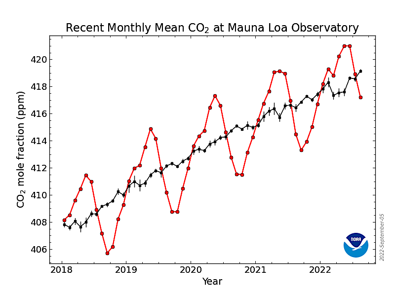
the monthly average concentration of carbon dioxide in the atmosphere fluctuates between summer and winter, but is steadily rising
Source: National Oceanic and Atmospheric Administration (NOAA), Trends in Atmospheric Carbon Dioxide
The model was the "Montreal Protocol on Substances that Deplete the Ozone Layer," an international agreement adopted in 1987. Signatories agree to lower the emissions of fluorinated gases (F-gases) with chlorine and bromine which depleted the ozone layer high in the mid-latitude stratosphere. Expansion of the "ozone hole" above Antarctica allowed more harmful ultraviolet radiation to reach the surface of the earth at levels that would result in millions of skin cancer cases.
Nations made slow but steady progress. Production of chlorofluorocarbons (CFC's) was banned in 2010, except when used to make other chemicals. In 2016 the Kigali Amendment was adopted, banning production of hydrofluorocarbons (HFC's) except as an intermediate feedstock for production of other chemicals.
Chlorofluorocarbons and hydrofluorocarbons in the atmosphere contribute to global warming far more than carbon dioxide. Eliminating the release of F-gases helped reduce global warming as well as the depletion of the ozone layer. The Kilgali Amendment was expected to prevent up to 1°F of global warming.
In 2022, the US Senate ratified the Kigali Amendment to the Montreal Protocol. The Kigali Amendment to the Montreal Protocol had worldwide support, and had already been signed by 136 other nations. The atmosphere does not sit over just one country, so worldwide action is necessary to manage climate change.
By 2022, ozone-depleting substances in the mid-latitude stratosphere had been reduced by 50%, and were below levels measured in 1980. After China stopped rogue emissions of the CFC-11 chlorofluorocarbon used to make foam insulation from factories in Xingfu, the National Oceanic and Atmospheric Administration (NOAA) calculated that the ozone hole in the Arctic should recover by 2045 and the hole at the South Pole should return to normal around 2066.
The ozone shield can be disrupted by external forces as well as human-caused pollution. On October 9, 2022, a jet of gamma rays streaming from a supernova crossed Earth's path. The supernova had exploded 1.9 billon years ago, when most life on Earth was unicellular and living in the oceans. The high energy photons crashing into the ionosphere and stratosphere disrupted the ozone layer. Ozone and nitrogen molecules were ionized, and those molecules did not block solar radiation until electrons were recaptured a few minutes later.
The probability of a closer gamma ray burst disrupting the zone layer for weeks or months was very very low, but the even showed scientists that the risk was greater than zero.
In 2023 a watchdog private organization discovered unauthorized emissions from some of the 15 plants in the United States making hydrofluorocarbons as a feedstock chemical. The Environmental Investigation Agency flew above chemical plants in Louisiana and Texas with infrared spectroscopic gas detection equipment that identified plumes of chlorofluorocarbons and hydrofluorocarbons being released into the atmosphere. The watchdog group also detected hydrofluoroolefins (HFO's), a substitute gas for refrigeration equipment which did not interact with the ozone layer but was a "greenhouse gas" that trapped heat.
Opponents of ratifying the Kigali Amendment tried to claim it would handicap American businesses and abdicate U.S. sovereignty over environmental regulation, but 69 Senators voted in favor. A spokesperson for the industry trade group, the Air-Conditioning, Heating and Refrigeration Institute, said:17
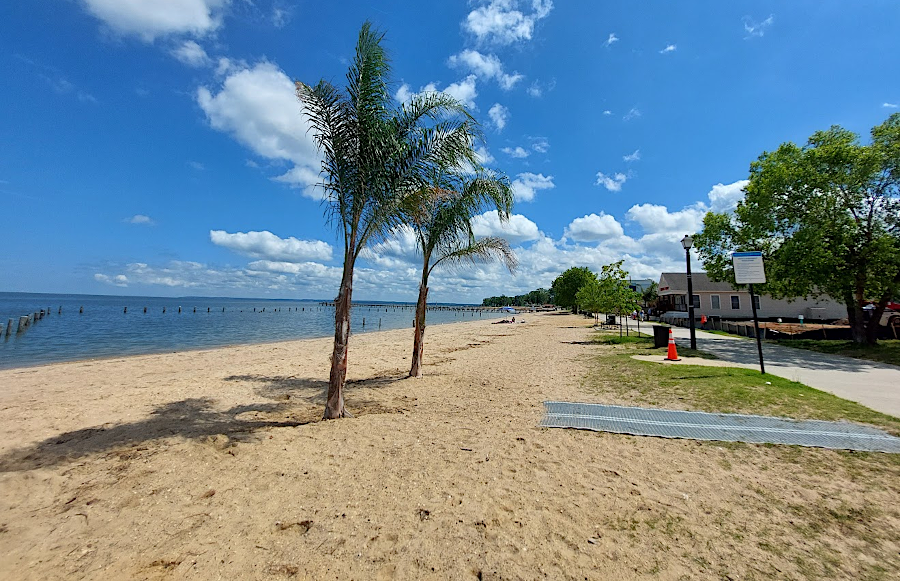
palm trees were surviving outdoors at Colonial Beach in 2025
The United States joined the Paris Agreement at the end of the Obama Administration, but President Trump withdrew from it. On his inauguration day in 2021, President Biden rejoined the Paris Agreement.
Local and state governments acted on their own initiative after President Trump revered Federal policy regarding climate change. To help meet the targets set in the Paris Agreement, in 2020 all 24 jurisdictions belonging to the Metropolitan Washington Council of Governments (MWCOG) adopted a 2030 regional greenhouse gas emissions reduction goal. They set a target of cutting the emissions from each jurisdiction to 50 percent of the 2005 emission levels by 2030.18
Different jurisdictions then began to create climate action plans, and appointed sustainability commissions to generate public support. One of the fastest to act was Fairfax County. Its Board of Supervisors adopted a Community-wide Energy and Climate Action Plan (CECAP) in 2021.
In Prince William County, the elected supervisors adopted Climate and Resiliency goals in 2020 and authorized a Sustainability Office in 2021. In 2022 the county created a Sustainability Office and the supervisors appointed a Sustainability Commission of local residents to oversee creation of a Community Energy and Sustainability Master Plan (CESMP) in 2023. That citizen commission quickly began considering "fast-track" action steps which could be funded in the next county budget, as the first step in implementing the Community Energy and Sustainability Master Plan.1819
The City of Manassas took advantage of expertise at George Mason University to draft its action plan. That city's Sustainability Task Force also began meeting in 2022.20
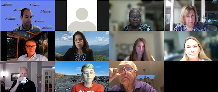
the first meeting of the Sustainability Plan Task Force for Manassas was in September, 2022
Source: City of Manassas, Manassas Sustainability Plan Task Force Meeting 9-21-22
The General Assembly passed legislation and Virginia joined ten other states in the Regional Greenhouse Gas Initiative (RGGI) in 2020. Th goal of RGGI was to reduce carbon dioxide emissions from utilities generating electricity by 30% by 2030. Based on an annual cap on emissions, utilities purchased allowances through a quarterly auction process. By 2022, Virginia had received over $450 million in RGGI revenue.
The legislators committed 50% of the revenue for energy efficiency upgrades to new and existing residential buildings for people with low incomes. The Virginia Department of Housing and Community Development uses that funding for the Housing Innovations in Energy Efficiency (HIEE) program to weatherize and improve housing units across the state.
The General Assembly directed that 45% of the revenue from the auction would be directed to the Community Flood Preparedness Fund. For the first time, the state rather than the Federal government provided major grants to local jurisdictions to deal with flooding risks and impacts. Significant funding was sent to Buchanan County after storms in 2021. The benefits of the Community Flood Preparedness Fund were not limited to coastal communities exposed to rising sea levels.21
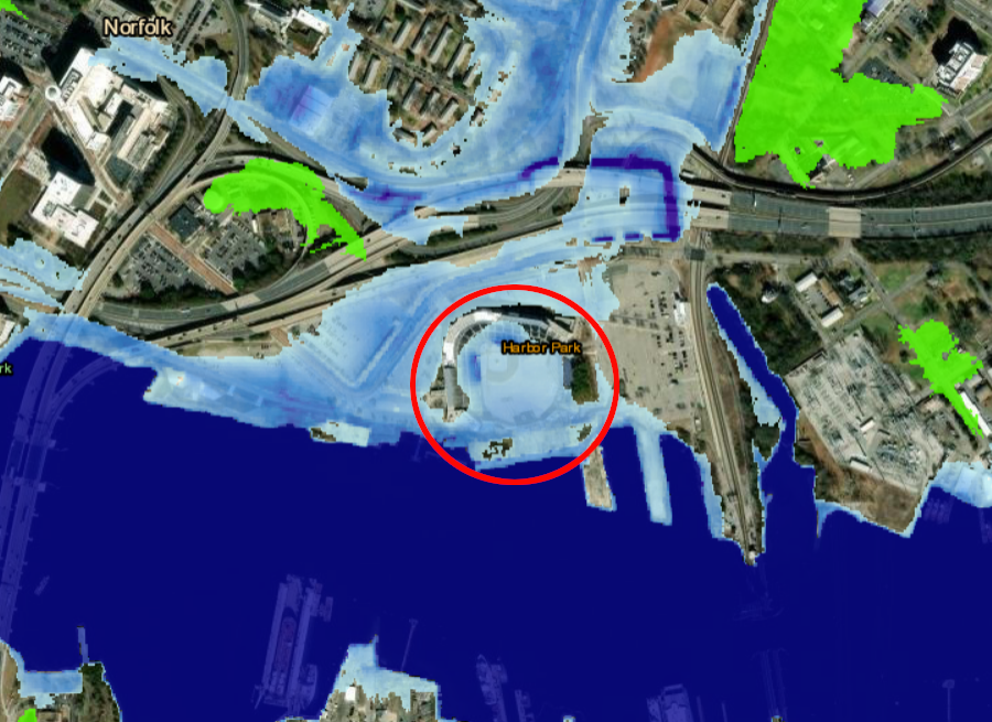
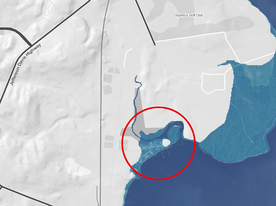
Harbor Park, the location of Norfolk's baseball park and planned casino, would be underwater if sea level rose five feet
Source: National Oceanic and Atmospheric Administration (NOAA), Sea Level Rise Viewer
Governor Youngkin was elected in 2021, and he sought to withdraw Virginia from the RGGI program. Utilities recovered their expenses from purchasing allowances by rate increases, so customers ultimately paid for allowances. From Governor Youngkin's perspective as a Republican, the costs of the auction were viewed as a tax to cut. Bills paid by Dominion Power customers included a RGGI "rider" of $2.39/month for 1,000 kWh until Dominion dropped that charge in July 2022, anticipating Virginia would drop out of RGGI.
The governor sought to use his executive authority to withdraw from RGGI. The Democratic legislators who controlled the State Senate in 2022-23 argued that Virginia had joined RGGI after the General Assembly passed a law to do so. In the eyes of the legislators, the governor's appointees who dominated the Air Pollution Control Board could not modify Executive Branch regulations and pull Virginia out of the initiative.22
The dispute ended up in the courts to decide. After the Air Pollution Control Board withdrew Virginia from RGGI at the end of 2023, the 2024 General Assembly debated whether to mandate rejoining through language in the 2025-26 biennial budget. The final budget compromise omitted such language. On June 3, the State Corporation Commission authorized Dominion Energy to remove the $4.50/month charge on customers' electricity bills as of July 15, 2024. That charge was being collected to cover RGGI costs.23
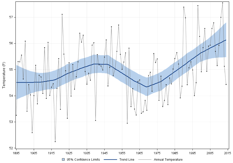
the average temperature has been rising in Virginia since 1970
Source: National Oceanic and Atmospheric Administration (NOAA), Temperature Trends by State
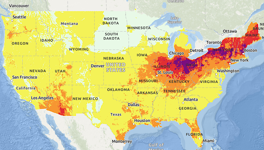
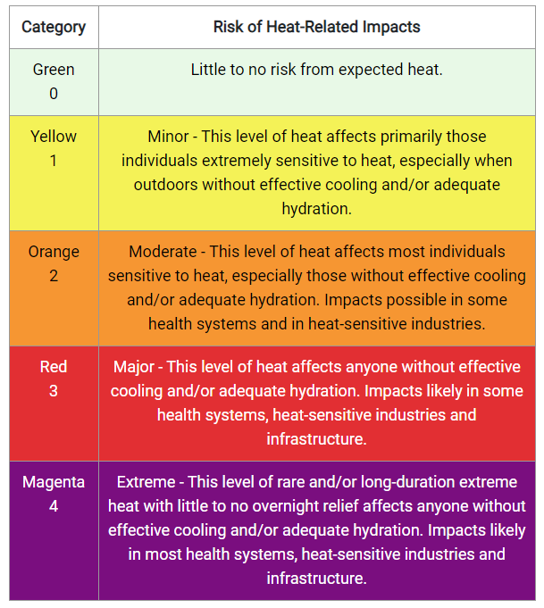
a "heat dome" (slow-moving high pressure system) in 2024 brought dangerously-high temperatures to the eastern United States
Source: National Weather Service, Heat Risk

in the Pliocene Epoch three million years ago, sea levels were higher and the coastline was at modern I-95
Source: Dr. Ron Blakey, Paleogeography and Geologic History of North America
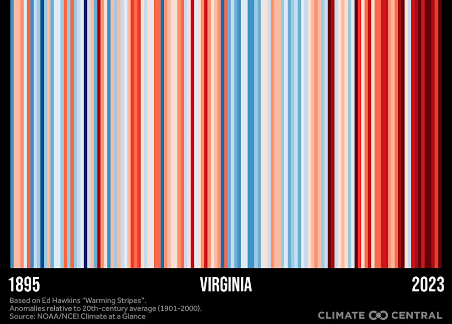
red stripes show years when annual Virginia temperature exceeded the 1971-2000 average; blue stripes are cooler years
Source: Climate Central, State Warming Stripes through 2023
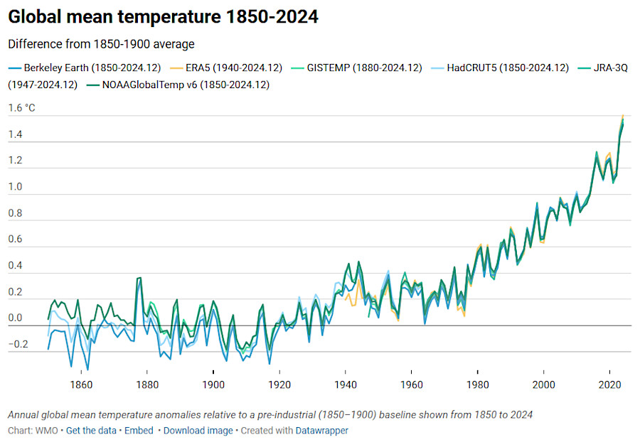
by 2024, the average global temperature was 1.55 degrees Celsius (2.79 degrees Fahrenheit) above pre-industrial levels
Source: World Meteorological Organization, State of the Global Climate 2024
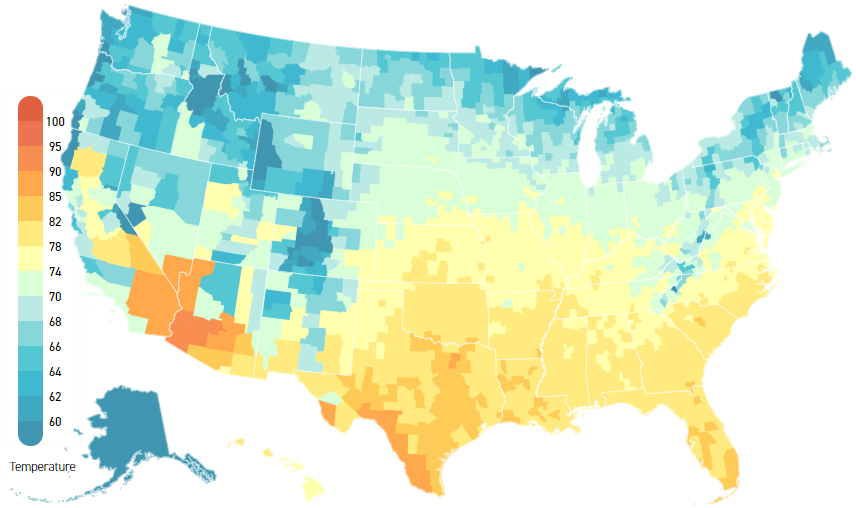
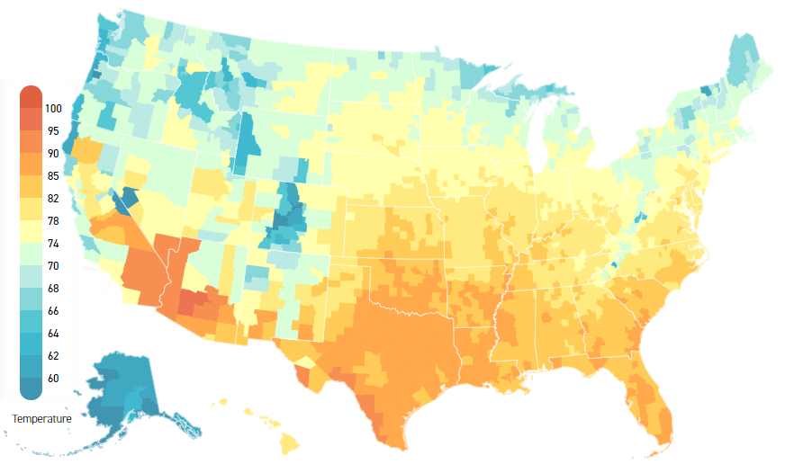
climate change will result in higher average temperatures in summer months (1981-2010 on top, 2040-2059 on bottom)
Source: Climate Impact Lab, Climate Impact Map