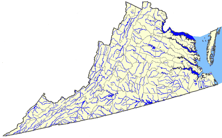
Virginia rivers and boundaries of political jurisdictions
Source: National Atlas
Virginia rivers and boundaries of political jurisdictions
Source: National Atlas
Virginia is governed by political jurisdictions - 95 counties and 38 independent cities. However, water ignores the political boundaries and obeys instead the law of gravity. Water flows across the political boundaries. The Potomac River gets water from Pennsylvania, West Virginia, Maryland, the District of Columbia, and Maryland as well as Virginia. The Chesapeake Bay even gets water than runs off the land in a portion of Delaware and New York state - so cleaning up the excessive amounts of pollution flowing into the Chesapeake Bay will require lots of political cooperation in order to "Save the Bay."
Within the state, Virginia's fragmented cities/counties are gradually implementing a regional approach to dealing with wastewater treatment, drinking water supplies, and pollution control. Urban areas such as Northern Virginia and Hampton Roads have established confusing and overlapping relationships between counties/cities regarding how drinking water is obtained and wastewater is processed. For example, the Corps of Engineers provides drinking water to Falls Church and Arlington as well as the District of Columbia, but not directly to the Fairfax County utility (Fairfax Water). However, the City of Falls Church sells water to customers in Fairfax County, as does the separate City of Fairfax - which gets its water from reservoirs in Loudoun County.
At the other end of the water distribution system, in the Blue Plains wastewater treatment plant the District of Columbia processes sewage from portions of Loudoun and Fairfax counties. Sewage from Dulles Airport and areas nearby is piped underneath the Potomac River to Blue Plains, because the Federal government built both the airport and the sewage plant. Just because you live in Fairfax County does not mean the county provides you drinking water or wastewater services. Utilities developed their pipes and treatment plants based on topography more than political boundaries, to take advantage of gravity to move the water/sewage through the system - so watershed boundaries may be more important than city/county boundaries.
Watersheds can be defined as large units (i.e., Chesapeake Bay watershed, Ohio River valley watershed), and those large units can be subdivided into smaller and smaller subwatersheds. Because so much effort in Virginia is focused on the cleanup of the Chesapeake Bay, at times the state agencies will divide the state into two categories: Chesapeake Bay and Southern Rivers.
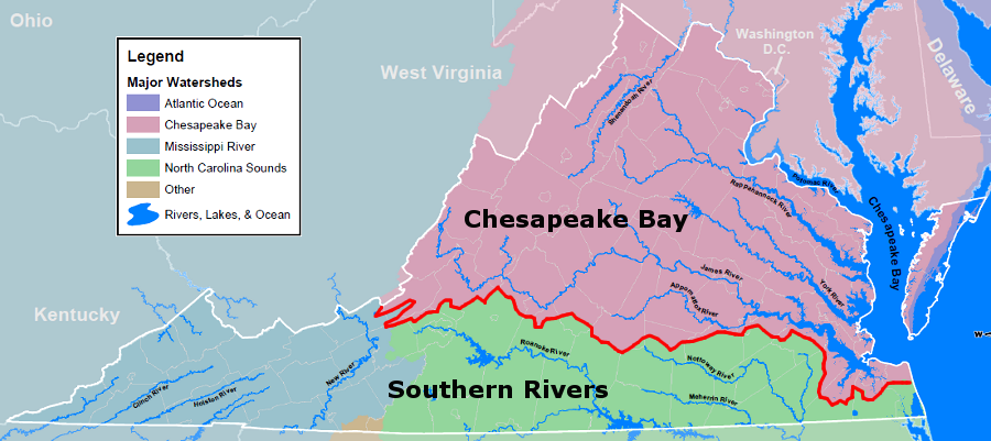
boundary between Chesapeake Bay and Southern Rivers watersheds
Source: Virginia Department of Game and Inland Fisheries, Virginia Watersheds
"Southern Rivers" is a catch-all political definition for watersheds in Virginia other than the Chesapeake Bay watershed. To make it even more confusing, the basins on the Eastern Shore that drain into the Atlantic Ocean are managed as part of the Chesapeake Bay watershed for state grant programs. That may conflict with topography and hydrology - but including all of Accomack and Northampton counties with the Chesapeake Bay watersheds is far simpler, administratively and politically.
As Geographic Information System (GIS) technology expanded in the 1990's through Federal agencies with different management challenges, those agencies defined watersheds at different levels of detail. The US Geological Survey (USGS) divided the Nation into 21 major geographic regions, using a 2-digit code. Virginia watersheds were included in 4 of the 21 regions defined by USGS: Mid-Atlantic Region code (02), South Atlantic-Gulf (03), Ohio (05), and Tennessee (06).
USGS subdivided the country into 4 separate levels, starting with the 21 regions and ending with 2,264 Cataloging Units. Each Cataloging Unit was defined by a unique 8-digit Hydrologic Unit Code (HUC). Virginia had about 50 of the 8-digit Cataloguing Units. For example, the Middle Potomac-Anacostia-Occoquan HUC code was 02070010.
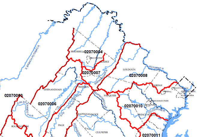
8-digit Hydrologic Unit Code boundaries (Middle Potomac-Anacostia-Occoquan HUC code is 02070010)
Source: Virginia Department of Conservation and Recreation, Soil and Water Conservation
The need for more-detailed, smaller hydrologic units triggered different agencies to create maps at even finer levels of detail. At one point, the 8-digit HUC codes were being extended by different agencies to 14 digits. After significant effort to coordinate requirements, Federal agencies have established the 12-digit (6th level) Watershed Boundary Dataset and are mapping according to common standards. The smallest, most-detailed 6th level (the "subwatersheds") are normally 10,000-40,000 acres in size. That may be small enough to manage, allowing a clear connection between who generates pollution, who would benefit from investments in reducing pollution - and who should pay for the cleanup.
At times, Virginia water managers discuss 14 "river basins" (Potomac River, Rappahannock River, York River, James River, Atlantic Ocean Coastal, Chesapeake Bay Coastal, Chowan River, Albemarle Sound Coastal, Roanoke River, Yadkin River, New River, Clinch-Powell Rivers, Holston River and Big Sandy River) in the state. These are not defined by the Watershed Boundary Dataset classifications, however, so the potential for confusion remains high whenever a report references a "basin."
In a few cases, water is transferred across watershed divides. Hydrologic units are defined by the water flow, including subsurface flows and waters piped across watershed divides - in contrast to the topographic watershed boundaries that define watersheds. The Virginia Department of Transportation occasionally builds stormwater ponds that redirect water from one stream into another.
On a much different scale, Virginia Beach has built a pipeline to withdraw drinking water from the Roanoke River. Analysis of the hydrologic unit for Virginia Beach's water supply would reveal that pollution in the Roanoke River could affect health and safety of the city's drinking water. If the analysis was restricted to just the watersheds/river basins in Virginia Beach, the threat would not be identified.
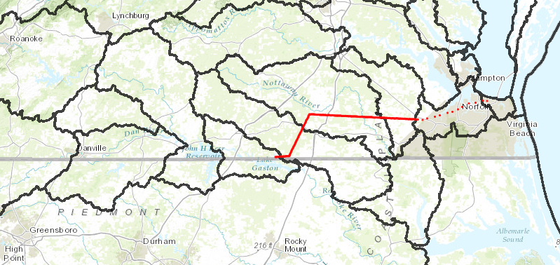
Virginia Beach is not located in the Roanoke River watershed but its water system (red line) taps into Lake Gaston, so the city could be considered part of the Roanoke River hydrologic unit
Source: Virginia Department of Conservation and Recreation, Virginia Hydrologic Unit Explore
As noted by the National Resources Conservation Service:1
The Virginia Department of Conservation and Recreation phrased the distinction in a different way:2

Virginia hydrologic units
Source: US Geological Survey Hydrologic Unit Maps