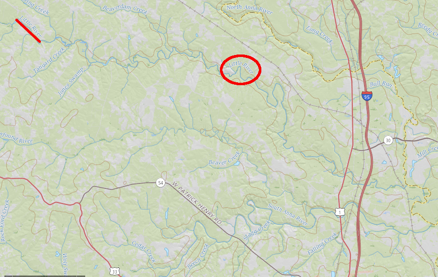
one "Little River" is a tributary of the North Anna River, north of Ashland
Source: US Geological Survey (USGS), National Map
one "Little River" is a tributary of the North Anna River, north of Ashland
Source: US Geological Survey (USGS), National Map
If you live near Ashland, the Little River is a small stream in the Pamunkey watershed (HUC 02080106) between the North Anna and the South Anna - there's a sign on the side of Route 1 when you cross it. If you live in Goochland County, there's a separate Little River near Manakin on the north side of Sabot Island in the Middle James-Willis watershed (HUC 02080205).
There's yet another "Little River" in Augusta County, in the South Fork of the Shenandoah River watershed (HUC 02070005). Those who live in Russell County near the Tazewell County line consider "Little River" to be their local stream in the Upper Clinch River watershed (HUC 06010205). If that isn't confusing enough, there are two streams called "Little River" in the Upper New River watershed (HUC 05050001) - one in Grayson County and one in Floyd/Montgomery.
If you live in Northern Virginia, however, the Little River is a stream in the Middle Potomac - Catoctin watershed (HUC 02070008) that runs from the Blue Ridge to Goose Creek and the water source that powered Aldie Mill.
From the George Mason University campus in Fairfax, go north on Route 123 to its junction with the Little River Turnpike at the Fairfax County Courthouse. Go west to Route 50, and follow the old turnpike path westward. Go past Fair Oaks Mall, Greenbriar, Chantilly, and Dulles Airport. Cross Route 15 at Gilberts Corner, and within a mile you will cross a narrow stone bridge. The Little River supplies the waterpower for Aldie Mill, on the left as you head west.
NOTE: If you miss the bridge and mill and end up in the swank shopping district of Middleburg, you went too far. If you end up in Winchester... or followed Route 50 all the way to Sacramento... consult a geography student for a map-reading tutorial.
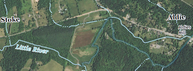
the Little River Turnpike runs from Alexandria to Aldie, where it intersects one of the streams called "Little River" in Virginia
Source: US Geological Survey (USGS), Middleburg 7.5 x 7.x topographic quadrangle map (Revision 1, 2013)
The watershed for the Little River includes much of northeastern Fauquier County, in the Mosby Heritage Area. If you drive west on I-66, the area north of the interstate between The Plains and Marshall is the headwaters of the Little River. US Route 55 follows more closely the divide between the Little River and Broad Run (which helps form the Occoquan River). The engineers who built I-66 had the earth-moving equipment to construct cuts and fills, creating a straighter road compared to Route 55.
The Little River flows north from I-66, past some Fauquier wineries, the Aldie Mill, and then joins Goose Creek before flowing into the Potomac near Leesburg. George Carter of Oatlands (a historic plantation house on Route 15 between Gilberts Corner and Leesburg) once planned to build a canal to the mill, and there are still remains of the canal locks just to the right of Route 7 where it crosses Goose Creek, at the old Xerox Training Center property.
Virginia has six streams named "Little River." There are at least 122 other streams with the same name in 29 other states, according to the Geographic Names Information System (GNIS).1

there are at least 128 streams named "Little River" in 30 states, including six in Virginia
Source: US Geological Survey (USGS), Geographic Names Information System