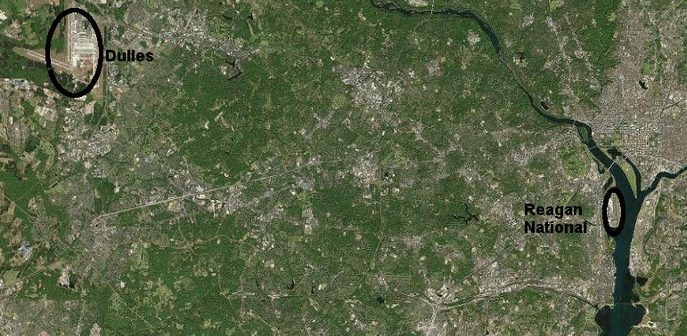
Two airports offering commercial passenger service are located in Northern Virginia, Washington Dulles International Airport (IAD) and Reagan National Airport (DCA). They are the busiest civilian airports in Virginia. In addition, the airport at Manassas is scheduled to offer commercial flights in 2027.
Both Washington Dulles International Airport and Reagan National Airport were built by the Federal government, and are still Federally-owned. In contrast to the competition in Richmond/Hampton Roads, both Dulles and Reagan National are managed by one organization, the Metropolitan Washington Airports Authority (MWAA). That essentially eliminates competition between the two airports, and at times allows one to subsidize the other.
There is still competition, from across the state line. Maryland active boosts its Baltimore-Washington International Thurgood Marshall Airport (BWI) in Baltimore. The low fares and large number of daily departures offered by Southwest Airlines in particular can draw passengers across the border from Virginia, from as far south as Richmond.
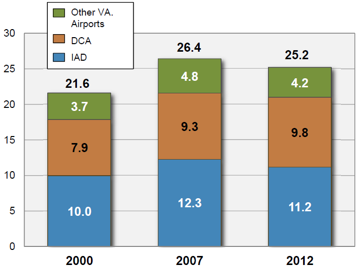
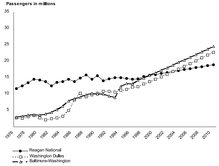
Dulles and Reagan National have the vast majority of commercial passengers getting on/off planes at Virginia airports, 2000-2012
Source: Virginia Department of Aviation, 2013 Virginia Air Transportation System Plan Update
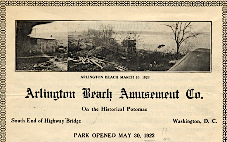
Prior to the development of Hoover Field as the first commercial airport serving the District of Columbia, pilots of surplus World War I Navy "flying boats" would land on the Potomac River next to the Arlington Beach and Amusement Park. That whites-only recreational site opened on May 30, 1923. It had a diving board placed on wooden float in the river, canoe rentals, arcade, dancing pavilion with live orchestras, a merry-go-round, and a roller coaster known as "The Whip."
Hoover Field purchased the Arlington Beach and Amusement Park in 1929 for expansion of landing space
Source: Arlington Historical Society, Facebook post (May 30, 2024)
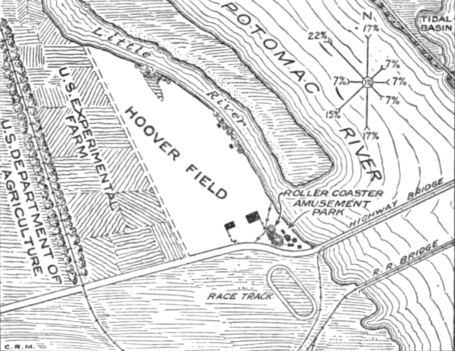
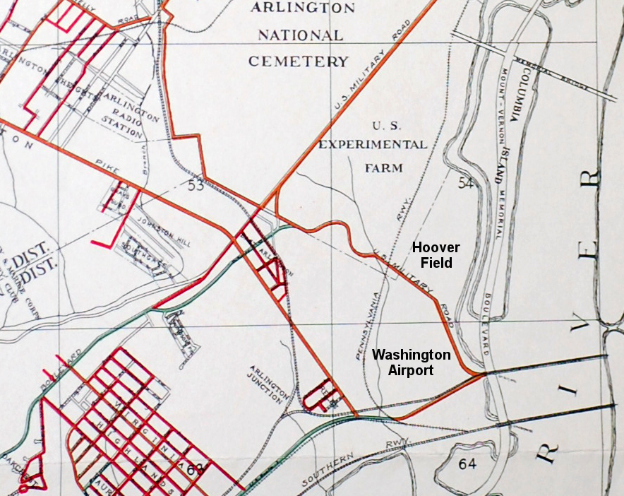
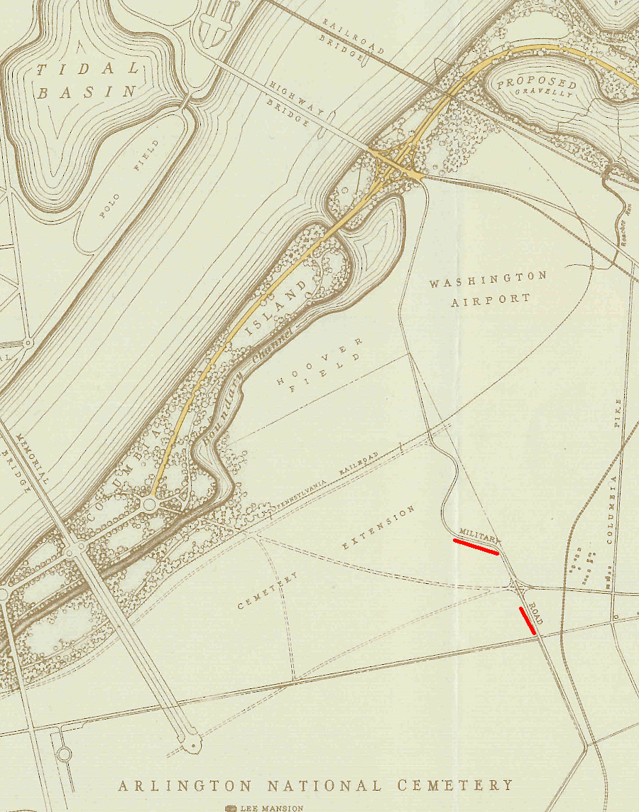
The first municipal airport for the District of Columbia was a private field located near the Virginia terminus of the 14th Street Bridge, called Hoover Field.
Philadelphia Rapid Transit started scheduled passenger service from Hoover Field to Philadelphia in 1926. There was not enough revenue to cover costs, and the company went bankrupt before the year ended. Potomac Flying Service then began operations at Hoover Field.
Hoover Field was located upstream of the 14th Street Bridge, and on the Virginia side of Boundary Channel ("Little River")
Source: Department of Commerce, Airway Bulletin No. 124 (1927)
In 1927, Washington Airport was built next door and just across Military Road. It originally served sight-seeing planes. The owners soon formed Seaboard Airways and started charter service for paying customers.
Washington Airport was located on land that had been a marsh separating Alexander's Island and the Virginia shoreline, but filled in by debris as the District of Columbia used it for a dumping ground.1
Military Road separated the fields used as a landing strip at Washington Airport and Hoover Field
Source: Arlington Fire Journal, Aircraft Accidents - 1929 and 1970
Hoover Field purchased the Arlington Beach and Amusement Park in 1929. The two private airports merged in 1930 into Washington-Hoover Airport.
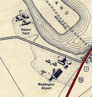
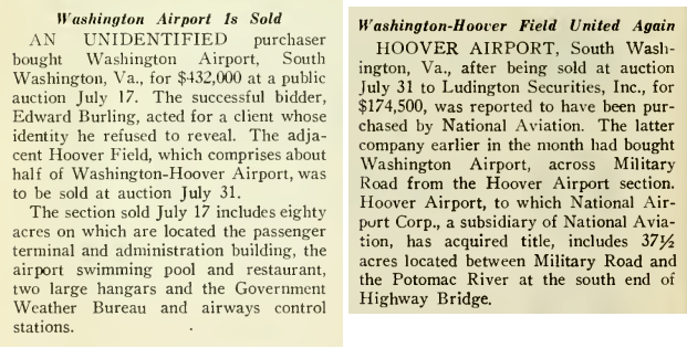
After the merger, an Art Deco terminal was constructed to service passengers and pilots. The two airports were sold separately in 1933, but purchased by the same buyer. Together the parcels totaled 146 acres, which was recognized at the time as small for an airport.
Pilots had great flexibility in how they chose to land. A 1951 retrospective commented:2
Landing or taking off to the north or south was not so bad, although engine failure north of the field would let you down on Columbia Island, then a bog overgrown with brush and willows. Bordering the field on the east was the amusement park with a high roller coaster, over which you had to slip for a precarious landing and a very short roll to the farm fence on the other side.
There were no such things as traffic patterns then, and you could approach the field any way you liked, make your turns where you pleased and land anywhere it seemed inviting. You could even spiral down directly over the landing area if the spirit moved you and make your landing out of a turn.
The Washington Airport property included the Airport Swimming Pool used by local residents as well as traveling pilots, plus one of the ice cream stands opened in the area by Herbert Beck. Each Polar Bear stand was a square shed designed to identify it with frozen custard. They were decorated with cement ice icicles, mirrors, and statues of poplar bears waving at customers.
One employee, Carl Sponseller, moved to Fredericksburg and opened his own custard stand there. Carl's became an iconic part of the Fredericksburg community. Its 1953 structure is now listed on the National Register of Historic Places. The modern experience of eating ice cream there has a heritage that dates back to the Washington-Hoover Airport.3
Washington-Hoover Airport included a swimming pool in 1933
Source: Internet Archive, Aero Digest (August and September, 1933)
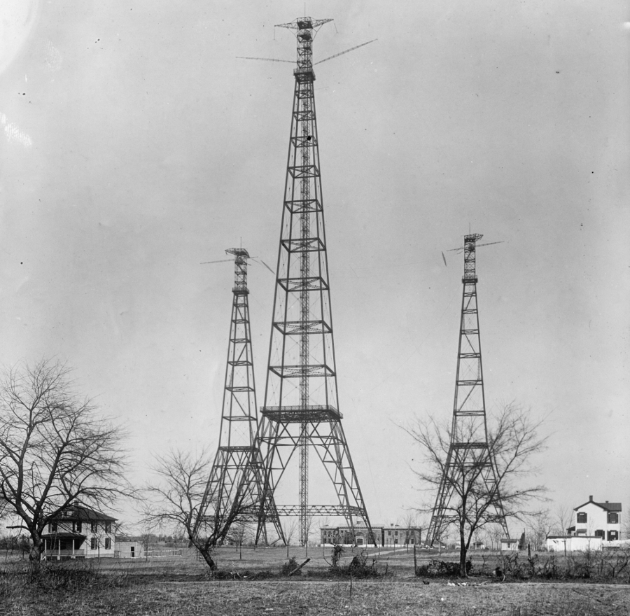
The runway at the Washington-Hoover Airport was obstructed by the three tall (450-600' high) towers of Arlington Naval Radio Station, which had been built in 1913 at Fort Myer. Despite complaints from pilots, the Navy declined to move the radio towers to enhance safety at the new private airport.
the US Navy's radio towers at Fort Meyer were a safety hazard to airplanes throughout the life of the Washington-Hoover Airport
Source: Library of Congress, US Navy radio towers in Arlington County, Virginia (1917)
Electricity lines strung on poles at the southeastern end of the runway along Arlington Pike were also significant safety hazards. The Public Utilities Commission in the District of Columbia ordered the overhead wires removed from property considered within the boundaries of the District of Columbia in 1932. The House Judiciary Committee held hearings on the issue, and finally concluded that the lines were within the District.
The utility resisted for three more years the order to move the wires, claiming they overhead power lines were outside the jurisdiction of the Public Utilities Commission. After a plane hit a similar power line in California and three people died, the Potomac Electric and Power Company finally agreed in 1935 to move the wires.
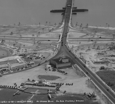
In 1928, the Graf Zepplin visited Washington Airport. In 1929, the Washington Airport purchased the Arlington Beach and Amusement Park. That recreational site adjacent to the Potomac River had opened in 1923, and hydroplane rides were one of its attractions. The roller coaster was demolished, to create three 500' runways and improve safety.
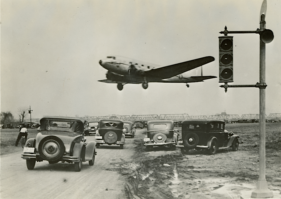
Traffic on Military Road had to be blocked by guards, before planes could take off or land. Attempts to close Military Road were supported by the Federal government, but opposed by Arlington County officials.4
Washington Airport and Hoover Field, separated by Military Road
Source: Arlington Public Library, 1931 road improvement map
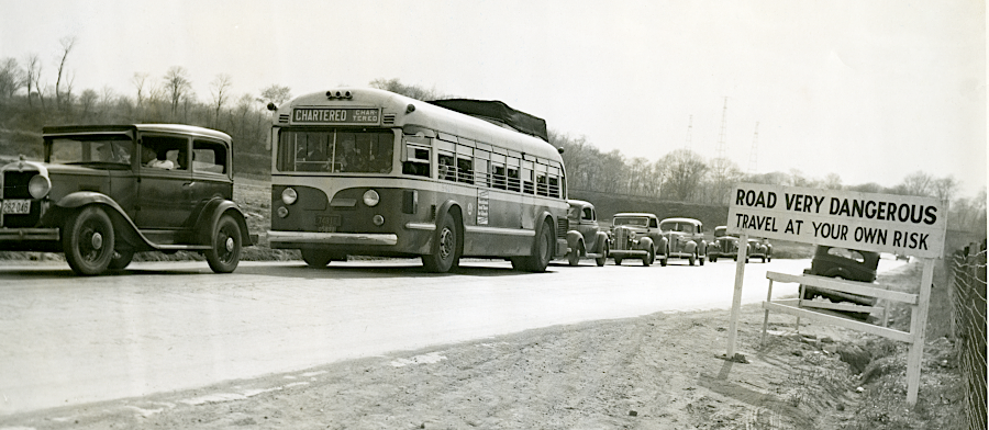
using Hoover Field required competing with automobile traffic
Source: Charlie Clark Center for Local History, Arlington Public Library, Low Flying Plane; Road Very Dangerous (used by permission)
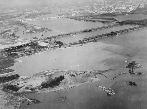
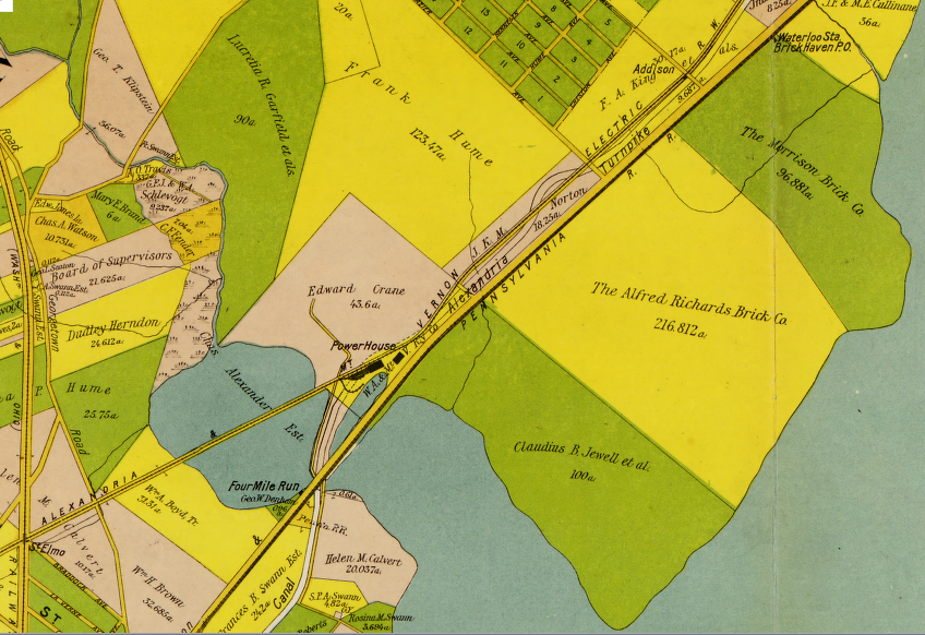
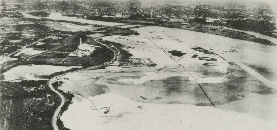
Constant complaints by commercial pilots about the safety of Washington-Hoover Airport produced hearings by the US Congress, but no action to fund a public airport. President Roosevelt finally stepped in. He selected the at Gravelly Point site, a mud flat downstream from the highway and railroad bridges crossing the Potomac River.
One advantage of that location was that the mud flat lay below the high-water line, and the Federal government owned the bed of the Potomac River. The land along the Potomac River had been brickyards 50 years earlier.
National Airport under construction
Source: Charlie Clark Center for Local History, Arlington Public Library, Future Site of Washington National (used by permission)
National Airport was built in 1938-1941. The US Navy finally removed the Arlington Naval Radio Station towers before the new airport opened on June 16, 1941. Unlike Washington-Hoover Airport, National Airport was owned by the Federal government. For a Federally-owned airport, the US Navy gave higher priority to safety issues.
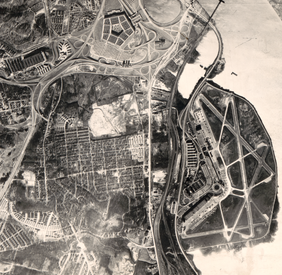
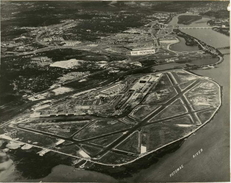
The opening of National Airport freed up the space occupied by the small Washington-Hoover Airport. In August, 1941, President Roosevelt ordered that the new headquarters for the War Department be located at the old Washington-Hoover Airport location. The Pentagon opened there in 1943.
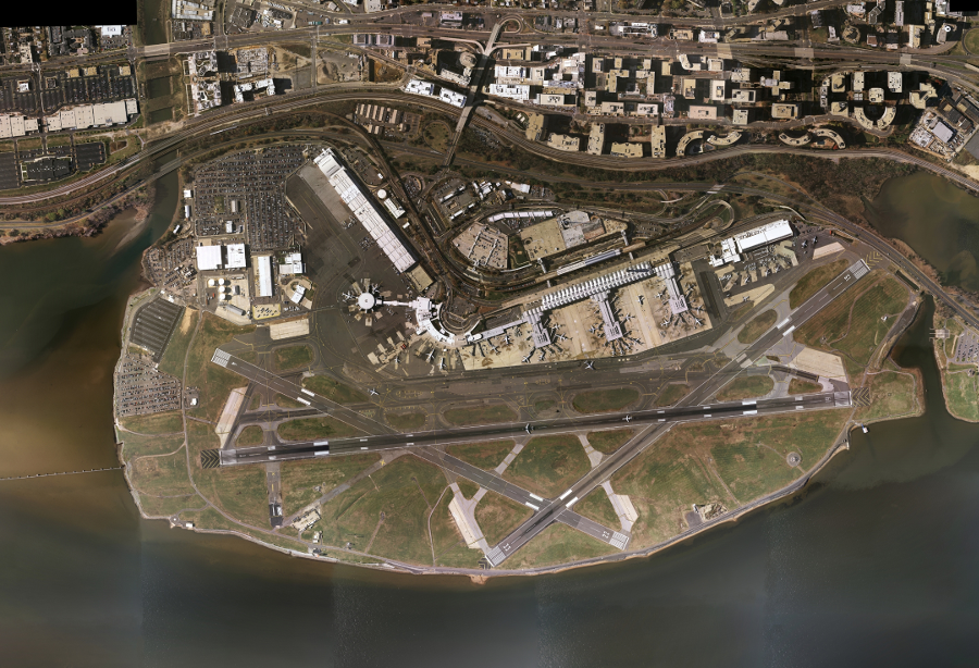
the name of National Airport (DCA) and the terminal have changed since 1941, but not the main runway configuration
Source: Metropolitan Washington Airports Authority, Then Aerial shot of DCA 1940's
National Airport was constructed on land that had been occupied for 15-20,000 years. When English colonists arrived the area was controlled by tribes allied with the Piscataway in a paramount chiefdom, which was ruled by a tayac who lived across the Potomac River.
The first English colonist to patent the future site of National Airport was ship captain, Robert Hawson. He obtained a land patent for 8,000 acres, a reward for transporting 120 people to labor-starved Virginia. Hawson sold his rights to the land on the south bank of the Potomac River, between modern Arlington Cemetery and Woodrow Wilson Bridge, to John Alexander. His grandson Gerard Alexander built a brick mansion house on a plantation which became known as Abingdon.
John Parke Custis, son of Martha Dandridge Custis Washington (whose second husband was George Washington), owned the property at one point. The Custis ancestors lived in Abingdon, England. A separate Custis family plantation called Abingdon was on the Eastern Shore.
The mansion house burned in 1930. The only remaining intact brick wall is probably from the kitchen or another outbuilding. When National Airport was planning additional parking, preservationists were successful in their effort to protect 3/4 of an acre with the ruins in 1998. Garage A and Garage B were built on either side of the historic Alexander homesite.
While the historic focus at Abingdon was once the connection to George Washington and the Custis family, in 2024 interpretive signs were added to illuminate the presence of 300 enslaved people who worked at the site before the Civil War.
The US Army Corps of Engineers was responsible for the construction of the original National Airport. Dredges moved sediments from the river bottom to create new land for the runways, and relocated a portion of the Mount Vernon Memorial Highway.
As the economy boomed in 1941, the Corps struggled to find reliable workers. According to a history published by the US Army:5
Turnover of labor was a big problem. Much of it comprised "floaters" who worked long enough to get a few dollars and then walk off the job, with a pair of government boots, a shovel or some other implement and migrate to another climate.
Sometimes a man didn't even collect what was due him but simply disappeared. They also disappeared in other ways. A careless step and fall overboard in the darkness of the night left no trace until subsequently the remains of arms, legs and other portions of the anatomy were discharged on the fill, the body having been drawn into the dredge line and ground up in the cutterhead.
Because the new National Airport was constructed on a mudflat that was formerly part of the Potomac River and its floodplain, it was not clear if the new facility was located in the District of Columbia or Virginia. The mudflat had been below the high-water mark, but construction altered the shoreline and created a new high-water mark.
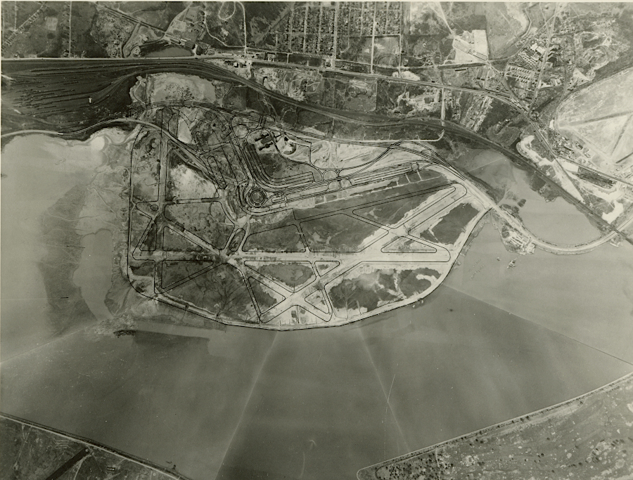
National Airport and the Pentagon in 1946
Source: Library of Congress, Central Virginia (1946)
In 1945, Congress defined the boundary as the new high-water mark created by the airport's fill. That placed the airport in Virginia.6
World War II and the advent of jets made clear that National Airport would be unable to handle all the projected future traffic. In 1950, Congress passed the Second Washington Airport Act.
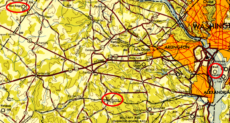
The Federal government's Civil Aeronautics Administration considered Annandale in Fairfax County and Chantilly on the Loudoun/Fairfax boundary (site of the existing Blue Ridge Airport), but chose the farming community of Burke as the site and purchased 4,500 acres.
The Federal government acted slower than urban sprawl. By the 1950's, the Fairfax County farmers who had relied upon the railroad depot at Burke Station to ship milk and produce to Alexandria/DC had been replaced by government workers commuting from new post-war suburban communities. The new residents had no desire for the noise and traffic of a new jet airport in their neighborhood, and they were white-collar workers with the skills and willingness to "fight city hall."
The Burke Airport Relocation Committee was effective at lobbying Congress to force reconsideration of the preferred site. Choices considered in the second selection process included Andrews Air Force Base, Pender (near Fair Oaks Mall in Fairfax County), and Baltimore-Washington International Thurgood Marshall Airport (known then as Friendship International Airport).
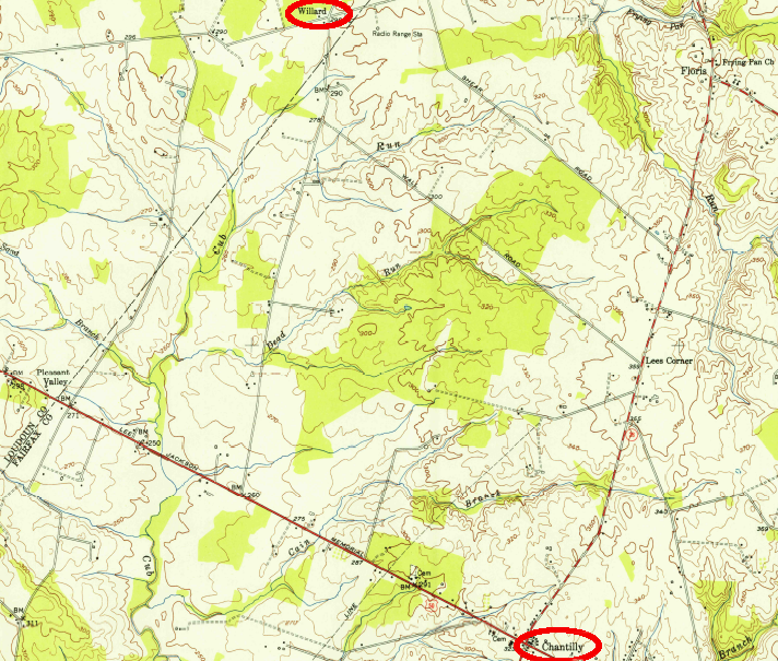
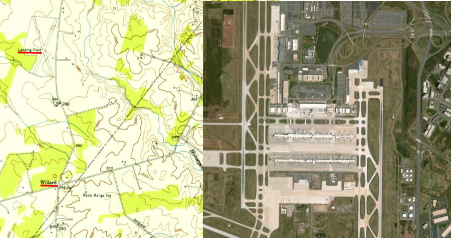
In 1958, President Dwight D. Eisenhower accepted his advisor's recommendation to build at the Chantilly site. It too was occupied, but the residents of the community of Willard were blacks in an era of segregation. Calling the airport site Chantilly after the nearest white community, and ignoring the name of the actual site occupied by blacks for 50 years, reflected the prejudices of the time as well as the relative prosperity of Chantilly vs. Willard.
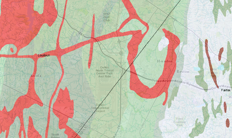
Dulles is located in a Triassic basin, providing a flat valley - though igneous dikes (colored red) increased construction costs of underground tunnels
Source: Virginia Department of Mines, Minerals and Energy, Division of Geology and Mineral Resources Online Mapping Tool
Unlike Burke, resistance by Willard residents to block the airport was not effective. The Federal Aviation Administration (successor to the Civil Aeronautics Administration) acquired 9,800 acres of land, removed 300 existing structures, and constructed a new airport. In the end, the airport was not named after any local geographic feature. The name commemorates Eisenhower's Secretary of State, John Foster Dulles, who died in 1959 from cancer.
the location for the second Federal airport to serve DC was called "Chantilly," but the actual location was at Willard
Source: US Geological Survey (USGS), Herndon 7.5x7.5 topographic quad (1951)
site of the current Dulles International Airport terminal in 1953 and 1972 (before expansion)
Source: Fairfax County, Historical Imagery Viewer
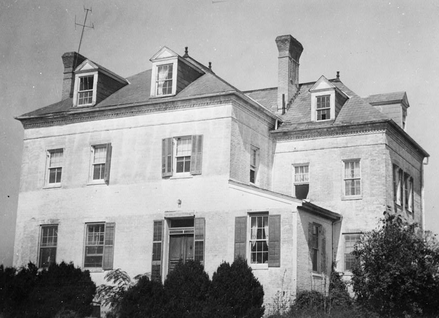
Public protests regarding transformation of the site revolved around protection of two pre-Civil War mansion houses. Public pressure forced the preservation of the 1799 plantation house at Sully Plantation, and it is now operated as an historic site by the Fairfax County Park Authority.
Protests were not sufficient to save the Leeton mansion house, which had been built between 1800-1820. It was destroyed, along with Shiloh Baptist Church and the homes of Willard residents, in order to construct the new airport:7
The crossroads of Willard and Sterling Rd have been covered in tarmac and are now home to the airport's 300-ft-tall control tower. Shiloh Baptist Church is but a mere memory on a patch of grass next to a runway. All that is left of Willard today are a number of vacant properties bordering the airport to the west that once contained farms.
the mansion house at Leeton was destroyed, along with homes and businesses of Willard residents and Shiloh Baptist Church, to construct Dulles International Airport
Source: Historic American Buildings Survey, Library of Congress, Leeton, 4619 Centreville Road, Chantilly, Fairfax County, VA (c. 1933)
Dulles then and now: the old Blue Ridge Airport and the community of Willard are now replaced by modern runways and the terminal complex
Source: ESRI, ArcGIS Online (using historical US Geological Survey 1951 map of Herndon)
Dulles opened on November 17, 1962, as the first airport built specifically to handle jet aircraft. Friendship Airport at Baltimore (now Baltimore/Washington International Thurgood Marshall Airport) had handled jets since 1959, and Maryland officials feared the Federal government would steer business to Dulles.
Maryland's leaders recognized that the new jetport would compete for business, and Maryland senator J. Glenn Beall called Dulles a "a federally conceived, federally planned, federally financed and federally constructed boondoggle." However, Dulles was designed to pull international flights away from airports at New York City more than from Baltimore. As jet travel replaced propeller-driven planes, Dulles was expected to surpass National Airport as well:8
During those early days of jet travel, New York City was the primary point of entry to the United States for diplomats and tourists. Dulles was going to change that, promising to transform Washington into an international gateway. That the airport was the first in the world built expressly for jet aircraft distinguished it from National Airport, whose runways were too short for jets of that era to land.
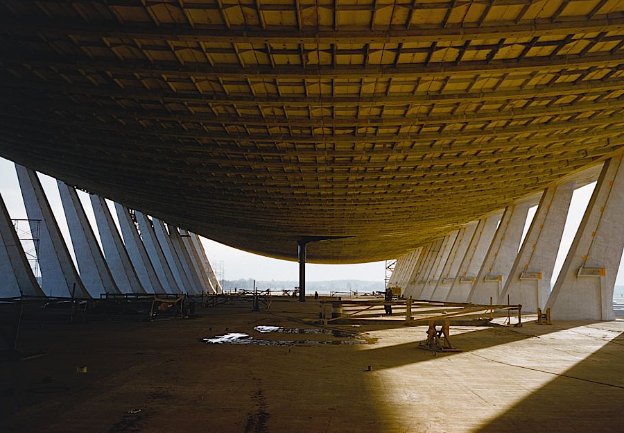
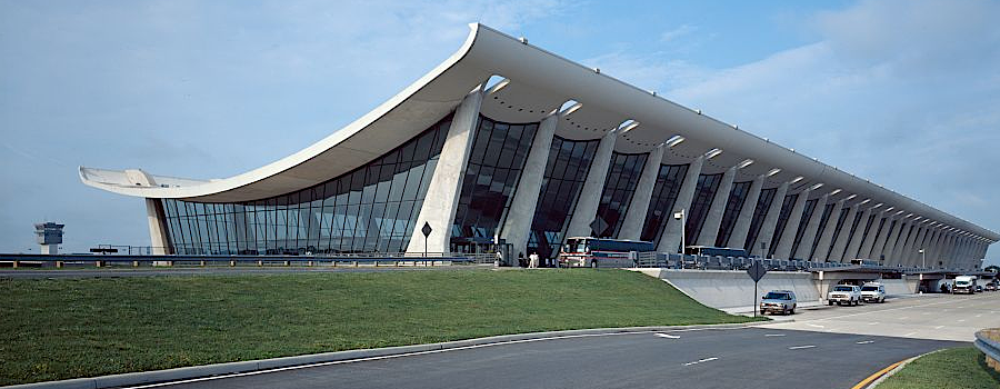
since 1962, the angled columns of architect Eero Saarinen's terminal have provided a sense of motion for passengers arriving at Dulles International Airport (IAD)
Source: Metropolitan Washington Airports Authority, Grand Opening Program (November 17, 1962)
Once jet aircraft first started flying into National Airport (DCA) in 1966, few passengers wanted to travel the extra distance to Dulles. The Federal government had built the 16-mile long Dulles Access Road dedicated to provide easy ground access, but the Chantilly site was still over 20 miles from the urban core in the District of Columbia. Dulles International Airport (IAD) was underutilized and considered to be a "white elephant." In 1975, 11.7 million people used National Airport while just 2.5 million used Dulles.
Congress sought to stimulate business at Dulles by limiting business at National. Jets flying out of National were limited in 1966 to destinations no further away than 650 miles, though airlines were authorized to continue using seven pre-existing routes with flights to destinations up to 1,000 miles away.
To manage congestion on airport runways, in 1969 the Federal Aviation Administration determined the maximum number of takeoffs/landings at five airports - John F. Kennedy International Airport (JFK), LaGuardia Airport (LGA), Newark International Airport (EWR), Chicago O'Hare International Airport (ORD), and National Airport (DCA). By 2025, the official slot limits had been eliminated at the Newark and Chicago airports. The Federal Aviation Administration still maintained a formal schedule review and approval process at those two airports plus Los Angeles International Airport (LAX) and San Francisco International Airport (SFO).
At what is now Reagan Washington National Airport, 60 "slots" per hour were allocated initially to different airlines to allocate arrivals and departures) between 6am-midnight.
The Federal Aviation Administration (FAA) modified the "perimeter rule" in 1981 to fix the limit for all flights at 1,000 miles. The US Congress extended the distance to 1,250 miles in 1986, in the same legislation that transferred Washington National and Dulles airports to the newly-created Metropolitan Washington Airports Authority.
Legislators from the western states regularly attempt to relax/abolish the Perimeter Rule. The Virginia legislature has supported the 1,250 mile perimeter rule, in part to minimize the noise burden in Arlington of long-distance jets.
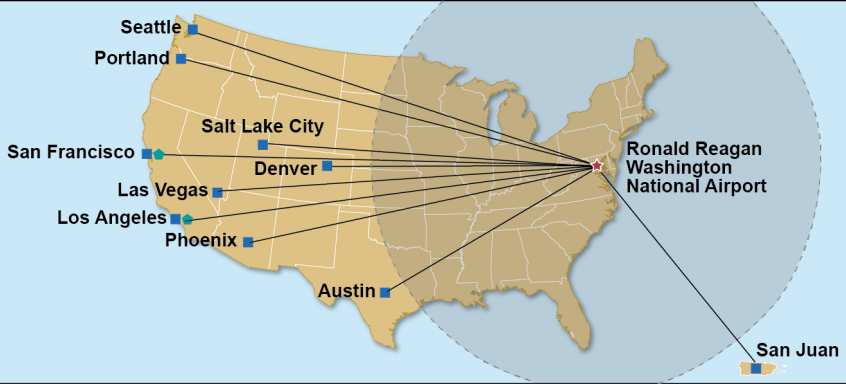
In 2000 the US Congress intervened to add slots, and some additions authorized six round-trip flights (12 slots) to points outside the perimeter. After two other Congressional actions to create new perimeter rule exemptions in 2003 and 2012, there were a total of 20 round trips each day to Austin, Denver, Las Vegas, Los Angeles, Phoenix, Portland, Salt Lake City, San Francisco, San Juan (Puerto Rico) and Seattle.
Until 2024, Congressional additions had been:
2000: 24 slot exemptions
12 beyond the perimeter
12 inside the perimeter
2003: 22 slot exemptions
12 beyond the perimeter
10 inside the perimeter
2012: 8 slot exemptions
8 beyond the perimeter
By 2023, Reagan Washington National Airport operated at 67 slots per hour. It had the busiest runway in the United Stares, with an average of 819 daily takeoffs and landings per day.
In 2023, a new group called the Capital Access Alliance launched another effort to modify the "perimeter rule" restricting the distance of most flights from Reagan National. Reps. Hank Johnson (D-Ga.) and Burgess Owens (R-Utah) introduced a bill in the US House of Representatives to allow 28 daily round trips to destinations beyond the 1,250 mile perimeter.
As had been argued since the perimeter rule was established, members of Congress from districts beyond the perimeter claimed that extending/eliminating the perimeter rule would increase competition and reduce costs. They also claimed Dulles was economically established, and no longer needed special protection to ensure adequate traffic.
Delta Airlines, which had major hubs in western states beyond the 1,250 mile perimeter, supported authorization of more long-distance flights. Supporting the existing perimeter rule were United Airlines, with a major hub at Dulles International Airport, and American Airlines, which was the dominant carrier at Reagan National.
Spirit Airlines sought to take advantage of the conflict and get some slots for taking off and landing at Reagan National. It proposed that carriers with existing slots be authorized to convert as many flights as they desired to locations beyond the 1,250-mile perimeter, but for each new flight going beyond the perimeter those carriers would have to release another slot which would be allocated to budget airlines such as Spirit for flights within the perimeter. Slots would be allocated in pairs, authorizing one takeoff and one landing.
Under that proposal, the total number of flights would not increase. However, more lower-fare flights would be scheduled and more carriers would compete for customers at Reagan National.
Members of Congress from the area near Reagan National argued in 2023 that the Silver Line had improved access to Dulles, and that airport was designed to support long distance flights. National's shorter runways were more suitable for short distance flights, with smaller aircraft and lighter fuel loads.
The Federal Aviation Authority's Air Traffic Organization estimated that adding 25 more flights per day would increase flight delays by one-third.
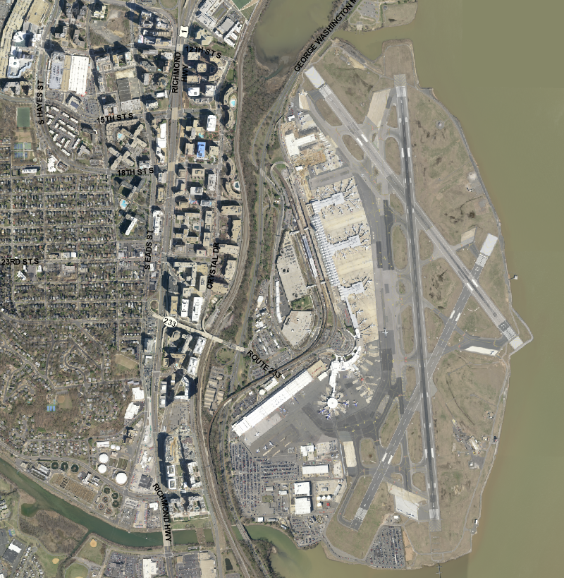
Reagan National was constrained with just 860 acres compared to the 11,830 acres at Dulles, and the airspace closer to the White House, US Capitol, and Pentagon was more restricted. Planned capacity for Reagan National was to accommodate 15 million passengers annually, but in 2022 it set a record of 24 million passengers.
Local members of Congress asserted that local residents should not be burdened by the extra noise from aircraft flying longer distances, and it was inappropriate from members from other districts to meddle in a local issue. In their opinion, Dulles International Airport (IAD) should remain the primary long-haul flight destination for the Washington metropolitan area.
The dispute blurred the hard partisan divide in the US Senate; alignments reflected allegiances to different airlines. Lawmakers from places with Delta hubs, both Republican and Democratic, advocated for a change in the perimeter rule. Lawmakers from United and American hubs opposed a change. Democratic Senator Mark Warner from Virginia commented:9
There's a number of Republican senators that fly disproportionately, frankly, out of destinations that American and United serve who are with us... This doesn't break down, candidly, on partisan lines. It breaks down on which airline already serves them.
the Capital Access Alliance lobbied in 2023 to end the perimeter rule limiting most flights longer than 1,250 miles from Reagan National (DCA)
Source: Capital Access Alliance, About the Issue
Back when jets were smaller, Federal officials had estimated that the airport could handle a maximum of 1,080 "slots" per day for aircraft takeoffs and landings. There were 890 slots being used at the time. Safety advocates argued that the airspace over the Potomac River near downtown Washington was already overcrowded, and that larger jets limited the capacity of the runways to less than 1,080 slots.
Sen. Ted Cruz from Texas led the fight that in 2024 successfully added five additional round-trip flights beyond the perimeter, an increase of 10 slots. Since 2000, the total increase had been 54 slots (takeoffs/landings), or 27 round-trip flights per day. 32 of those slot increases were for flights beyond the perimeter.
In the 2024 relaxation of the perimeter rule, Delta Air Lines won the debate within the US Congress by an 88 to 4 vote in the US Senate and a 387 to 26 vote in the House of Representatives. Even some Representatives from Virginia districts voted in favor. United Airlines at Dulles International Airport, American Airlines at Ronald Reagan Washington National Airport, and US Senators from Virginia and Maryland failed in their efforts to maintain existing flight limits but were able to constrain a requested increase of up to 56 slots.
After the final decision, new beyond-the-perimeter flights were authorized to San Antonio, San Diego, Seattle-Tacoma, Las Vegas and San Francisco. Delta won the right to fly to Seattle-Tacoma, while American Airlines was granted the right to fly to San Antonio. Jet Blue, Spirit, and Frontier were unsuccessful in bidding for new flights that would have served San Juan, Puerto Rico and San Jose, California.
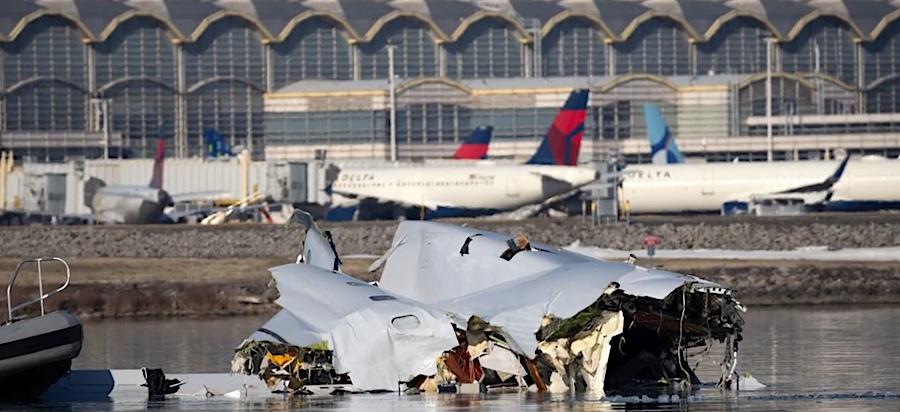
On January 28, 2025, before the 10 new daily flights had started, there was a mid-air collision at Ronald Reagan Washington National Airport. 67 people died when an American Airlines jet collided as it was landing with an Army helicopter; there were no survivors from either aircraft. As wreckage was removed from the Potomac River, the Federal Aviation Administration reduced the maximum rate of flights landing at the airport from 28 to 26 arrivals per hour.
Right after the crash, the New York Times reported that, during the 2024 debate about adding more slots, Virginia Senator Kaine had anticipated a disaster:10
Last year, as the Senate debated the latest round of additional flights, Mr. Kaine said he feared the prospect of people sticking a microphone in lawmakers' faces after a tragedy and saying "you were warned and you voted for it anyway."
Until 1987, the two airports in Northern Virginia were operated by the Federal Aviation Administration in the U.S. Department of Transportation. To streamline the process for making long-term capital improvements without interference from short-term political considerations, the Metropolitan Washington Airports Authority (MWAA) was created in 1986 and the airports were leased for 50 years (until 2067). The lease fee was set at $3,000,000/year in 1987, with adjustments for inflation.
US Secretary of Transportation Elizabeth Dole triggered the transfer process in 1984, recycling an idea proposed during the Nixon Administration 13 years earlier. The Reagan Administration devolved power away from the Federal government, and Secretary Dole considered the airport development to be an issue best resolved by local and regional officials. The Virginia congressional delegation championed the idea of a regional agency replacing the Federal Aviation Administration (FAA) as the operator of Dulles International Airport and what was known then as National Airport.
At the same time, she endorsed keeping the Federally-established "cap" or limit of the number of passengers t National Airport. She proposed reducing the cap at from a maximum of 16 million passengers/year set in 1981 by the Federal Aviation Administration to 15.2 million/year. That proposed cap was slightly above the curent use in 1984, while traffic at Dulles was far below capacity at just 3 million passengers/year.
The decision to arrange a 50-year lease, rather than transfer ownership, protected the ownership claim of Federal taxpayers who funded construction of the airports and the authority of Congress to control the sites. Reflecting its retained authority, in 1998 Congress renamed National as "Ronald Reagan Washington National Airport."
The airports authority, once it became an independent agency, issued long-term capital bonds financed by projected landing fees and concessioner profits. Borrowing money like a business, rather than relying upon Federal appropriations, enabled the authority to fund expansion of capacity and efficiency at both airports and compete more effectively with Baltimore-Washington International in Maryland.
Composition of the Metropolitan Washington Airports Authority reflects the political disputes over the management of the airports, and concerns of Maryland officials that Baltimore-Washington International should continue to thrive. The original composition of the Metropolitan Washington Airports Authority board was debated extensively in 1986. Ultimately, 13 people were appointed to the Metropolitan Washington Airports Authority, with 5 appointed by the Governor of Virginia, 3 appointed by the Mayor of the District of Columbia, 2 appointed by the Governor of Maryland; and 3 members appointed by the President.
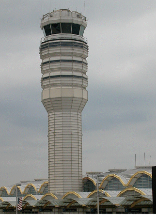
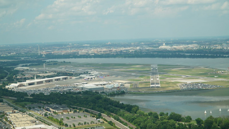
control tower at Reagan National Airport
The composition of the board was changed in 2012 to give Virginia more authority. The Metropolitan Washington Airports Authority had assumed responsibility for the Rail-to-Dulles project (Silver Line), and the Dulles Toll Road was transferred to the authority so it could raise tolls to fund the Silver Line extension. Costs ballooned past projections, contracting practices involved questionable ethics, and Virginia's governor was a Republican concerned that appointees made by the previous Democratic governor would sign a "project labor agreement" for Phase 2 of the Silver Line.
Under the previous governor, Tim Kaine, the Metropolitan Washington Airports Authority had signed a project labor agreement for Phase 1 and committed to union wages and working conditions. The other two local jurisdictions on the authority's board, Maryland and the District of Columbia, were governed by Democrats, and the President was also a Democrat sympathetic to organized labor.
After the airport stated in 2011 that it planned to require a project labor agreement for Phase 2, Gov. Bob McDonnell threatened to block distribution of $150 million in state funding. That caused to Federal government to slow down its funding commitments, so the Metropolitan Washington Airports Authority then softened its contract "requirement" to a "preference."11
After Federal law authorized expansion of the board and DC concurred, the governor of Virginia appointed two new members - over opposition of the incumbent board and Fairfax County officials, who objected to what they viewed as state interference. Today the legislation reads:12
The Airports Authority shall be governed by a board of directors composed of the following 17 members:
(A) 7 members appointed by the Governor of Virginia;
(B) 4 members appointed by the Mayor of the District of Columbia;
(C) 3 members appointed by the Governor of Maryland; and
(D) 3 members appointed by the President with the advice and consent of the Senate
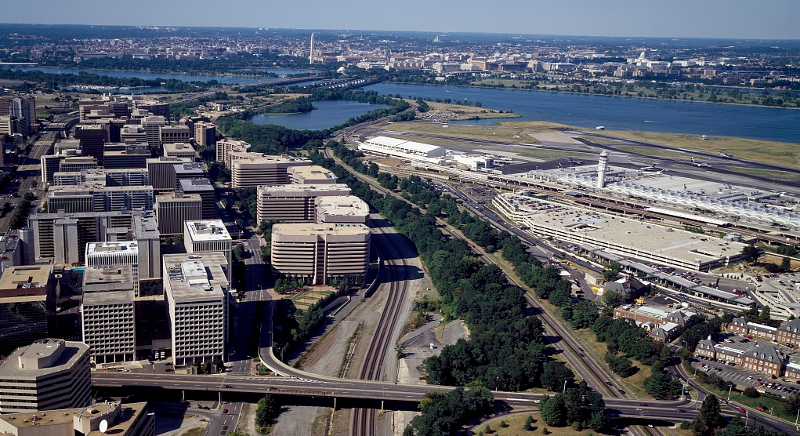
Dulles International Airport is 20 miles further west than Reagan National, and airline passengers flying to/from Northern Virginia and DC prefer the airport closer to the urban core
Source: ESRI, ArcGIS Online
Between 2007-2013, passenger boardings declined 10% at Dulles but increased 9% at Reagan National. United retained its dominance at Dulles during the 2007 recession, but American Airlines, US Airways, Southwest Airlines, and JetBlue chose to reduce their scheduled service from Dulles by 40% and retain/increase service from Reagan National - in part to protect their control over the limited number of "slots" allocated for landings and takeoffs at Reagan National, anticipating that traffic would recover after an economic recovery.
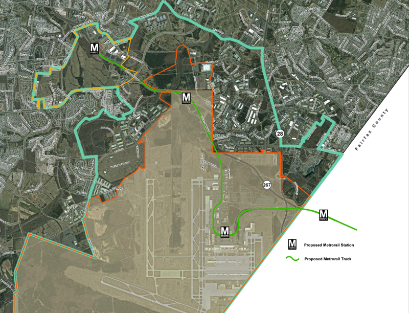
That shift has left Dulles as the secondary airport for domestic passengers, though it remains the primary airport in the region for international flights. Completion of Metrorail's Silver Line will make it easier for passengers to get from Dulles to downtown DC and to the inner suburbs such as Arlington, but closer-to-downtown Reagan National has won the contest for passenger service. In 2016, 11.5 million passengers boarded planes at Reagan National compared to 10.6 million enplanements at Dulles.13
the Silver Line of Metrorail goes past Dulles International Airport and is designed to spur transit oriented development in suburban Loudoun County, as well as transport airport passengers
Source: Loudoun County, Metrorail Service District
Both Dulles and Reagan National are managed by the Metropolitan Washington Airports Authority, so different jurisdictions do not provide competitive subsidies to attract/retain passenger traffic. Instead, the Metropolitan Washington Airports Authority responded in 2014 to the shifting patterns in passenger travel by proposing a $1 billion construction program at National and a revenue sharing agreement where National could send as much as $300 million to Dulles over the next decade to offset operating costs there.14
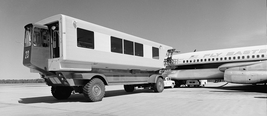
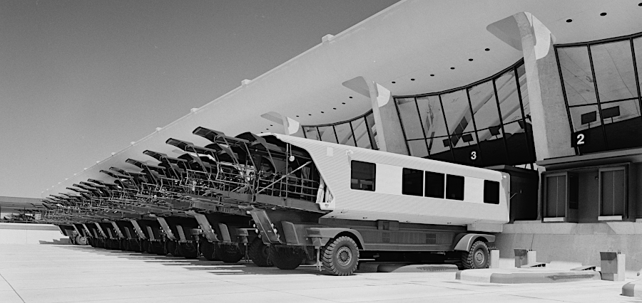
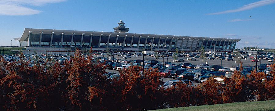
Dulles has the longest runways of a civilian airport in Virginia, and its location on the East Coast next to the national capital has helped make it a primary US hub for international trips as well as for domestic travel. The iconic mobile lounges ("people movers") were designed by the airport's architect, Eero Saarinen, to minimize the length of a walk from terminal entrance to the door of the airplane.
After mid-field concourses were expanded in 2000, passengers used jetways to access the concourse and then the mobile lounges shuttled passengers across the tarmac to the main terminal. Dulles A, D, and C gates became accessible by an underground AeroTrain in 2010, but international passengers landing at Concourse D still rely upon the mobile lounges because the cost to extend the AeroTrain to that concourse was too high.
In 2023, the Metropolitan Washington Airports Authority planned a $160 million project to rehabilitate the 49 mobile lounges. Renovation required almost completely replacing the materials on top of each old chassis. No company, not even the original two providers, was still building the vehicles. Restoration was expected to enable use of the people movers for another 20 years.4
Use of the mobilre lounges was planned to be eliminated in about 20 years Even after that time period the train was not expected to connect to the terminal for international arrivals, so some form of bus would be needed to replace the lounges for international passengers.
Eero Saarinen expected that mobile lounges would be more popular than a long walk through the hallways of a terminal, extended far from baggage claim in order to accommodate enough loading/unloading jets at one time. However, trains running on rails or guideways became the popular vehicle.
A former president of the Metropolitan Washington Airport Authority suggested why:15
Passengers arriving off a long-haul flight seem to see a ride on the mobile lounge, once described as a paragon of luxury, as a burden...
Now, travelers prize what little autonomy they have - choosing to stand, say, on the moving walkway. Said more simply, they tend to resent being captured for an additional period of time when all they want is to be let free to be on their way.
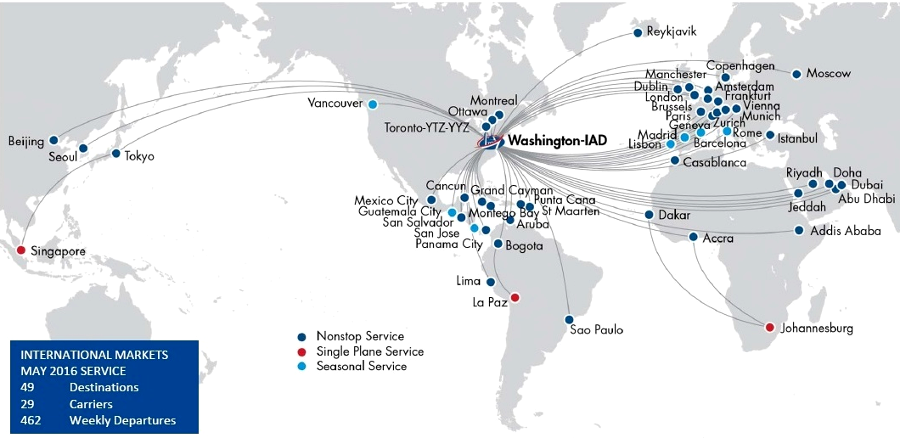
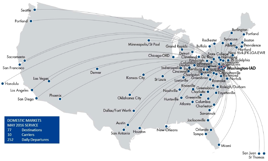
The Metropolitan Washington Airports Authority continues to manage Reagan National as a domestic hub, enhancing traffic and spreading out the flights to Dulles as much as possible. The only international destinations served by Reagan National in 2016 were Bermuda and three cities (Toronto, Ottawa, and Montreal) in Canada.16
the Metropolitan Washington Airports Authority manages Dulles as the international hub, limiting competition with Reagan National
Source: Metropolitan Washington Airports Authority, Maps of Nonstop Routes at Dulles International
Dulles serves as a domestic hub as well as the international hub, but relaxation of the Perimeter Rule has increased the number of domestic flights using Reagan National
Source: Metropolitan Washington Airports Authority, Maps of Nonstop Routes at Dulles International
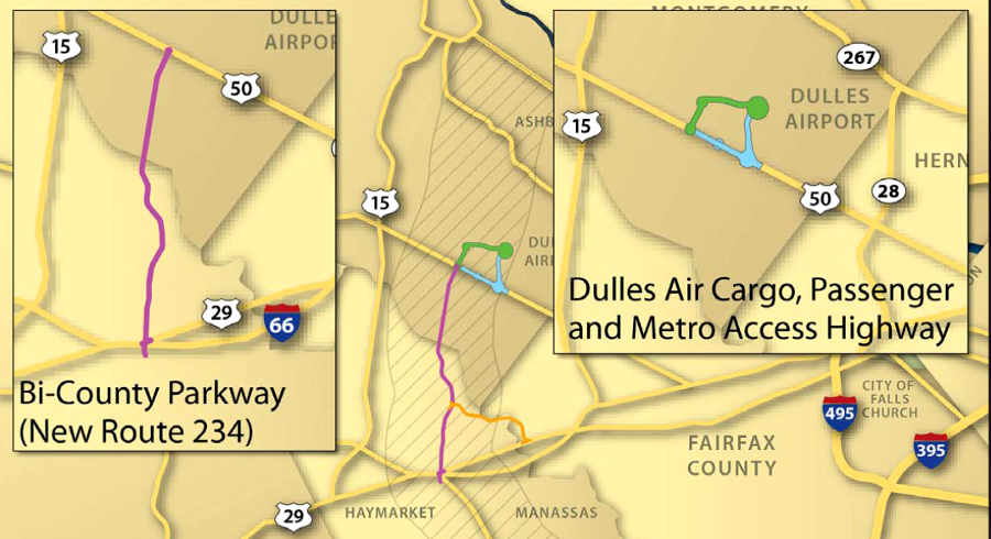
The Metropolitan Washington Airports Authority claimed in 2013 that new transportation projects such as the proposed Bi-County Parkway through Prince William/Loudoun counties would trigger a boom in cargo exports at Dulles. After opponents quickly debunked claims that increasing cargo traffic would create a significant number of jobs in the region, the Virginia Department of Transportation shifted its justification of that highway to emphasize safety and projected reductions in future traffic congestion.
In 2024, the Virginia Economic Development Partnership (VEDP) initiated another effort to establish Dulles as a cargo hub. The airport was within a one-day drive of over 50% of the population of the United States, and within a two-day drive of 75% of the population. Space for a dedicated cargo facility was already designated on the 12,000-acre airport property, the fifth largest airport in the world. Economic development officials targeted initial outreach to companies making time-sensitive deliveries, such as pharmaceutical firms, that would benefit from using an airport closer than New York or Chicago.
The challenge was to establish a supply chain with as much cargo to ship out of Dulles as would arrive, to justify airlines using cargo-only planes rather than just shipping cargo in the belly of passenger planes. As stated in a news article, the Virginia Economic Development Partnership had to:17
...convince global air freight operators not just that the region can support inbound demand, but that it also can pull in enough cargo to fill outbound aircraft. And businesses need assurance that cargo planes will fly to justify shifting from existing shipping lanes, a high order given the expense and time that goes into identifying these routes in the first place. In other words, it's a "chicken or the egg" scenario, as the supply of air service from freight operators and the demand for it from businesses have to emerge at the same time.
Travel though Dulles peaked at 27 million passengers in 2005 and it was the busiest airport in the region. In 2012 there were more passengers using Baltimore-Washington International Marshall Airport (BWI) rather than Dulles, and in 2015 Reagan National surpassed Dulles.
Airlines chose to schedule fewer flights from Dulles because of cost:18
At Dulles, the cost per enplanement had risen to about $25, compared with less than $14 at National and about $10 at BWI.
The Metropolitan Washington Airports Authority succeeded in reducing costs at Dulles, in part by raising revenue from commercial operations such as restaurants and by selling the 424 acres known as the Western Lands. Dulles was perceived as far away, but customers were increased by highlighting the relative time to reach it. Travelers in Bethesda, Maryland could get to Dulles in 28 minutes; Baltimore-Washington International Marshall Airport was 53 minutes away.
By 2018, traffic at Dulles exceeded Reagan National again. There were 24.1 million passengers passing through Dulles while 23.5 million flew through National. In the region, Baltimore-Washington International Marshall Airport was still the leader with 27.1 million passengers.19
A major upgrade to the terminal at Reagan National Airport was completed in 2021. A 14-gate concourse and new security screening buildings were added, the first purpose-built space for security since the 9/11 terrorist attacks, expanding the number of checkpoints from 20 to 28.
The changes reduced congestion between the ticket counters and the checkpoints. After the upgrade, only ticketed passengers could see the vista of the Potomac River through the glass walls of National Hall.
Gate 35X, which had been constructed in 1997 by US Airways for passengers to catch a shuttle bus to airplanes destined for regional airports, was closed. Gate 35X became famed as the worst airport gate in America, and its sign was carefully taken down and shipped to the American Airlines museum in Fort Worth. Employees took selfies to commemorate the final flight from Gate 35X - and reflecting the site's reputation, that flight was forced to return to the gate due to mechanical issues.
The four year, $1 billion Project Journey upgrade ended while air travel was still recovering from the COVID-19 pandemic. Air travel plummeted, and the number of passengers going through Reagan National dropped from 23.9 million in 2019 to 7.6 million in 2020.
Ronald Reagan Washington National Airport in 2022 served almost exactly the same number of travelers it did in the last year of the pre-pandemic era, while Washington Dulles International Airport still has some ground to make up. The 23,936,235 commercial-airline passengers traveling through Reagan National last year represented an increase of 71 percent from 2021 and was on par with the figure of 23,945,235 recorded in 2019
...In December, American Airlines had a market share of 58.8 percent of passengers at Reagan National, followed by Southwest (15.3%) and Delta (13.9%). At Dulles, United had a market share of 64.7 percent, followed by Delta (4.9%) and American (2.3%).
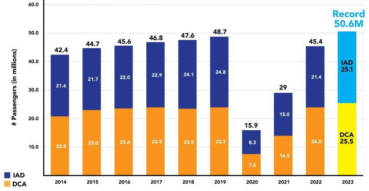
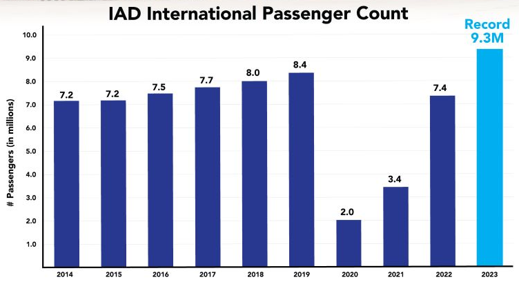
In 2023, both airports in Northern Virginia set records for the number of passengers; together, they processed over 50 million passengers for the first time. There were 25.5 million passengers last year using Ronald Reagan Washington National Airport. Dulles International Airport handled 25.1 million passengers, including 9.3 million international passengers.21
total number of passengers at the two Northern Virginia airports exceeded 50 million in 2023
Source: Metropolitan Washington Airports Authority, Washington’s Airports Set New Passenger Record (February 21, 2024)
international travel at Dulles International Airport recovered from COVID-19 in 2023
Source: Metropolitan Washington Airports Authority, Washington’s Airports Set New Passenger Record (February 21, 2024)
A $675 million investment to upgrade Dulles was proposed in 2022, after Project Journey was completed at Reagan National. Tier-2 Concourse (East) would replace the gates at the end of Concourse A used for regional flights. Those old gates required passengers to walk outside and climb stairs to enter a plane. The new 14-gate, three story complex would provide jet bridges for passengers to enter planes without going outdoors by the end of 2026.
The Dulles International Airport Master Plan continued to include a fifth runway, which has been part of the development plan for the airport since 1958. It will run north-south, in contrast to the fourth runway (Runway 1L-19R) which runs north-south and was completed in 2008. The Federal Aviation Administration (FAA) granted approval in 2008 for those last two runways.
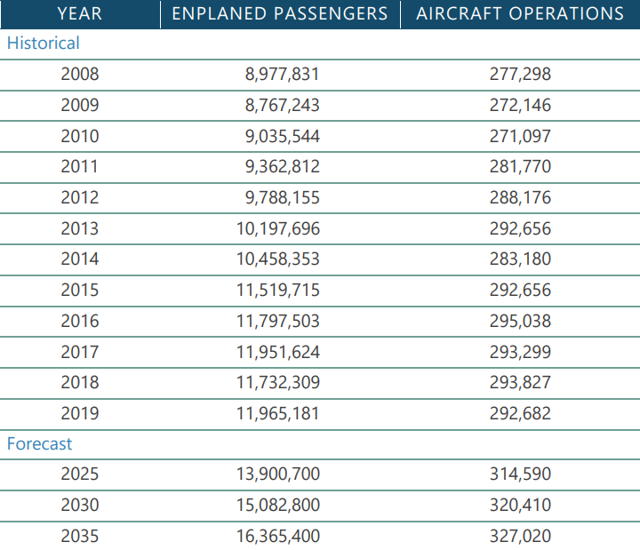
Traffic at Dulles was expected to grow from 12.3 million enplanements in 2019 to 17 million in 2045. Expansion was justified in part because no other major East Coast airport had space in which to grow.
What ended up being called Concourse E was designed for United Airlines to increase its international flights. Included in the project was a 40,000-square-foot United Club lounge.
The airline made a significant commitment to Northern Virginia, opening in 2025 an inflight training center in Chantilly to train flight attendants based at the three major airports around Washington DC. The facility included mock airplane cabins and aircraft door training stations.22
plans were announced in 2022 to create a new 14-gate concourse at Dulles for regional flights, comparable to the recent upgrade at Reagan National to replace Gate 35X
Source: Metropolitan Washington Airports Authority, Dulles International Airport Proposes New 14-Gate Concourse
Because there is just one main runway and one secondary runway at Reagan National, they could not be closed for repaving when required every 10 years or so. Instead, small portions 15' wide by 1,000' long are repaved each day after midnight, when aircraft stop taking off and landing. Quick-set asphalt hardens in each small section before operations begin again at 6:00am. It takes two years to complete the runway repaving job at that busy airport.23
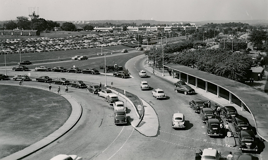
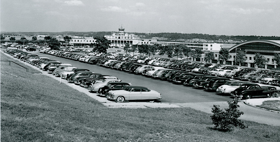
Project Journey at Reagan National did not solve the parking challenges, and passenger use was projected to exceed pre-COVID levels by 2023 or 2024. The airport had 8,909 public parking and 3,200 employee spaces, but traffic jams and full parking garages frustrated customers.
Though there was a Metrorail station right at the airport, employee parking was required because many airport operations occurred outside of the hours that Metrorail services were available.
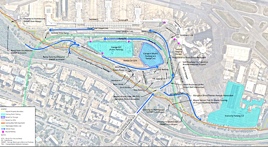
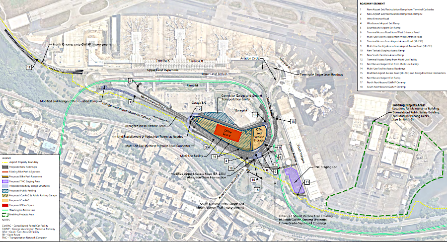
In 2023, the Metropolitan Washington Airports Authority (MWAA) announce a plan to realign roads and build a new garage and ground transportation center (curb space for passenger drop-off and pick-up) in the space between Garages A and B/C, plus a new staging area for ride-share cars provided by Uber and Lyft. That would add an additional 2,830 parking spaces. Also, the project would eliminate the need to lease office space in Crystal City by building 80,000 square feet for Metropolitan Washington Airports Authority (MWAA) staff.24
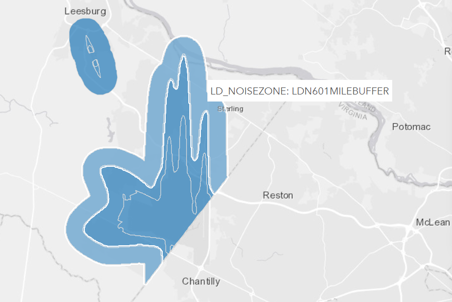
Because on complaints from flights into Dulles, Loudoun County sought to mitigate noise complaints by establishing an Airport Impact Overlay District in the 1990's. The Metropolitan Washington Airports Authority (MWAA) revised noise exposure maps in 2019. After Loudoun County updated the Airport Impact Overlay District (AIOD) in 2023, there were 59,000 parcels within the boundaries. With Metropolitan Washington Airports Authority support, the county added a requirement that potential homebuyers within the Airport Impact Overlay District had to be notified about airport-related noise:25
The Federal Aviation Administration has established the Day-Night Average Sound Level (DNL or Ldn) as a measure of community noise; this measure calculates the average noise level over a 24-hour period. Three tiers of noise are included in Loudoun’s AIOD:
Ldn 65 or Higher: Properties located within this area are closest to the airport. New residential development is not permitted in this area.
Ldn 60-65: Properties located within this area are closer to the airport. Any residential development in this area requires disclosures at the time of sale; acoustical treatments for new residential construction and new additions to existing residences; and an easement established prior to construction of a new residence granting the right of overflight in the airspace above the property.
One-Mile Buffer: Properties located within this area are farthest from the airport while still being located within the AIOD. This designation requires a disclosure notice to be included with each sale of residential property.
In 2024, however, the General Assembly blocked the requirement to notify purchasers of noise concerns, after the initial sale from a developer. As a result of that state action, Loudoun County had to revise its local zoning ordinance to eliminate the requirement that potential homebuyers within the 60 Ldn zone, and for one mile beyond that zone, be notified about possible noise impacts.
The action by the General Assembly to block the required disclosure by Loudoun County stood in contrast to other legislation. Starting in 2005 the state required a Property Disclosure Statement to potential purchasers for resale of houses within a noise zone or potential accident zone. The requirement applied in jurisdictions with a military air installation, or if the zone had been designated on the jurisdiction's zoning map.
Other risks also had to be disclosed, according to the new state law. In the Richmond Regional Planning District (Planning District 15), which included the Midlothian coal fields, potential buyers had to be notified if the property had previously been mined or if there were any abandoned mines, shafts, or pits.26
Loudoun County was blocked by the General Assembly in 2024 from mandating potential honebuyers be notified about airport noise
Source: Loudoun County, Loudoun Airport Impact Overlay Districts
The Federal Aviation Administration (FAA) received over 4,000 public comments when it conducted a review of its aircraft noise policy in 2021. Due largely to stricter noise certification standards for new aircraft, the Federal agency claimed:27
Since the mid-1970's, the number of people exposed to significant aviation noise exposure in the U.S. has declined from roughly 7 million to just over 400,000 today. At the same time, the number of enplanements (each enplanement equals one person flying on a single commercial flight) has increased from approximately 200 million in 1975 to over 850 million today. In 1975, one person on the ground experienced significant noise exposure for every 30 enplanements, compared to today where more than 2100 enplanements are flown for every person on the ground experiencing significant noise exposure.
In 2024, the Federal Aviation Administration changed the route used by planes flying from the north into Ronald Reagan Washington National Airport (DCA). Planes were routed closer to the Potomac River, and the LDA-Z arrival route closer to houses along the river's edge was eliminated. The Reagan National Community Noise Working Group had been established in 2015, and noise was a common agenda topic.28
after it was clear National Airport could not meet all demands for air travel in the 1950's, the two sites selected for a second Federal airport to serve DC were at Burke and then Willard/Chantilly, replacing Blue Ridge Airport
Source: US Geological Survey (USGS), Washington 1x2 topographic grid (1948)
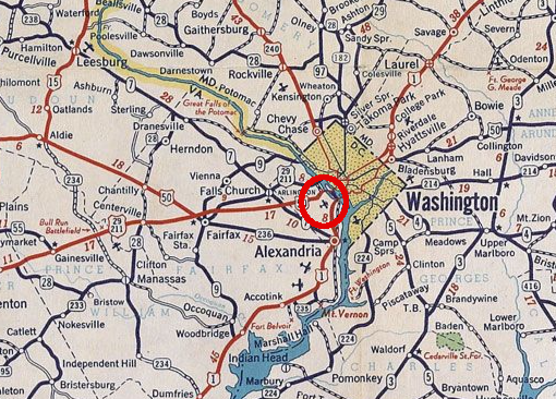
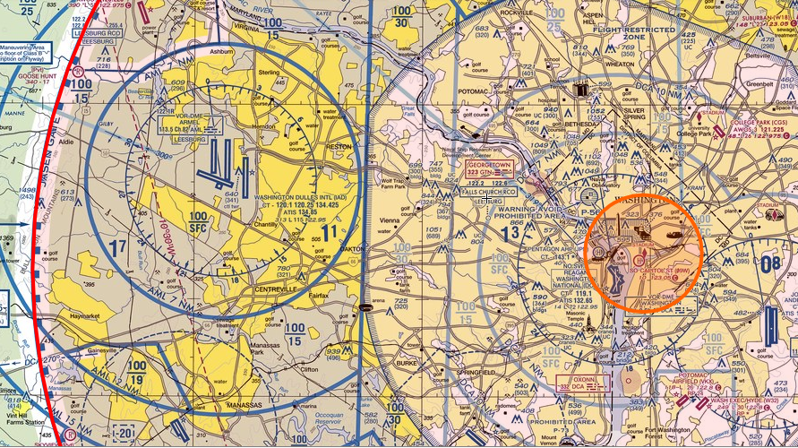
aeronautical chart for area including Dulles International Airport (IAD) and Reagan National Airport (DCA)
Source: SkyVector
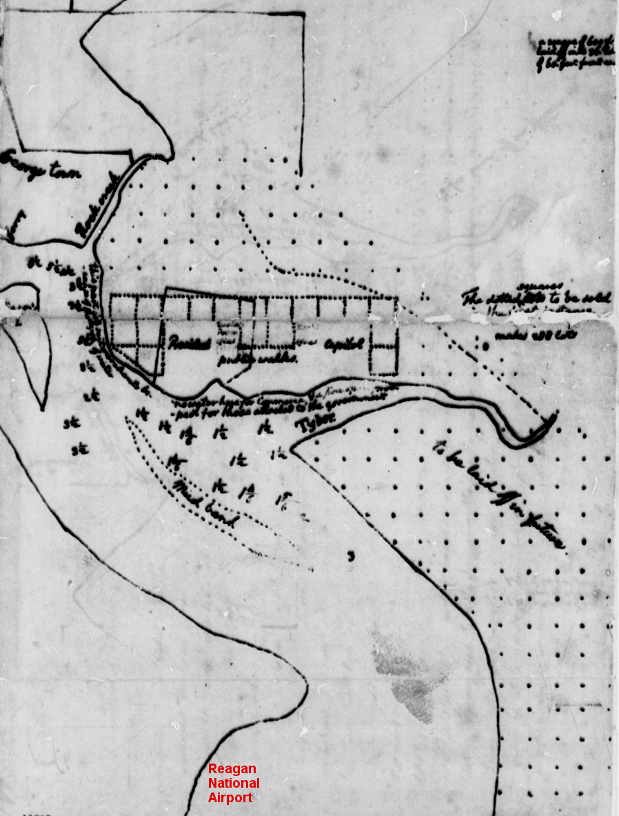
Thomas Jefferson, as Secretary of State, sketched the site of the future Reagan National Airport when he mapped the site of the new capital on the Potomac River in 1791
Source: Library of Congress, Proclamation of Federal District with Map (George Washington, March 31, 1791)