tolls paid by drivers using the 14-mile Dulles Toll Road will provide the majority of funding for the 23-mile Silver Line extension of Metrorail to Dulles airport
Source: Metropolitan Washington Airports Authority, Dulles Toll Road
tolls paid by drivers using the 14-mile Dulles Toll Road will provide the majority of funding for the 23-mile Silver Line extension of Metrorail to Dulles airport
Source: Metropolitan Washington Airports Authority, Dulles Toll Road
When Dulles was built, it was located in the Virginia countryside farther away from Washington than originally planned. To link the airport with the city, the Federal Aviation Administration (FAA) built a special limited access, 4-lane highway to provide fast ground transportation to the capital.
The Dulles Access Road initially offered a boring drive through the farms and woodlots of Fairfax County; old residents remember that only two structures were visible from the Dulles Access Road between the Capital Beltway and the airport to break up the visual monotony of the trip. Later, after construction of I-66, the Federal government funded an extension of the Dulles Access Road inside the Beltway to I-66.
Strong Federal management helped ensure that the road was not converted into a commuter highway, or to become another congested local road in order to facilitate development of nearby real estate. As described by General Pete Quesada, the first FAA administrator (appointed by President Eisenhower in 1959):1
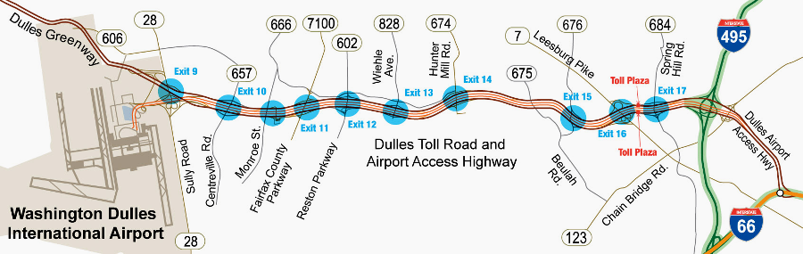
In 1984, after development of offices and housing between Dulles and I-495 (Capital Beltway), the Virginia Department of Transportation built the Dulles Toll Road. It is an 8-lane highway, with four additional lanes on either side of the Dulles Access Road, funded by tolls. The toll road and the expansion of Route 28 were built in response to new development, but were also designed to trigger construction of new offices and commercial growth between Dulles airport and I-495. Major corporations recognized the advantages of being near both an international airport and government customers in DC (especially defense and intelligence agencies).
Dulles Access Road remained free (and uncongested) exclusively for airport users, with a brief exception for commuter buses and high-occupancy vehicles during construction of the toll road.
The toll road was a success, spurring development from Tysons Corner to Herndon. In addition to corporate offices, the National Reconnaissance Office built a major facility south of Dulles.
The privately-built Dulles Greenway extended suburban sprawl westward to Leesburg, allowing residents in eastern Loudoun County to commute to job centers closer to DC and ultimately spurring commercial development west of Route 28. State and county transportation officials were unable to alter the Federal limitations on use of the Dulles Access Road, but commuter demand created a rare opportunity for Virginia to increase rates and make a substantial profit from the traffic that drove parallel to the free Dulles Access Road.
In 2008, Virginia transferred responsibility for the toll road to the Metropolitan Washington Airports Authority, along with responsibility for constructing the extension of Metrorail to the airport. State officials reognized that increased costs for the Silver Line would require toll increases, so relinquishing control over the toll road allowed state officials to shift future public objections towards the Metropolitan Washington Airports Authority. During the intense debates about the costs vs. benefits of building a longer tunnel beneath Tysons, or putting the Dulles airport station underground, the state officials had "plausible deniability" for decisions that increased tax burdens and commuter tolls.
the Silver Line is an economic development project, as well as a ransportation project
Source: Loudoun County, Board of Supervisors
Work Session (March 7, 2012)
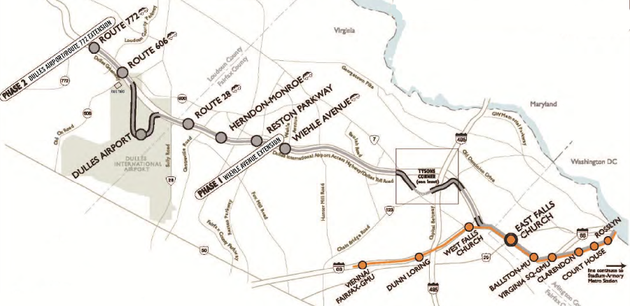
The airports authority divided construction of the Silver Line into two phases. Phase 1, from East Falls Church to Wiehle Avenue, will open in 2014. Phase 2, extending the line past Dulles to two additional stations in Loudoun County, is projected to open in late 2018. As each phase of construction is completed, the line will be transferred to the Washington Metropolitan Area Transit Authority (WMATA), and that agency will absorb the costs of operations.
The design to include two stations beyond the airport illustrates that the Silver Line in expected to be far more than just a transportation channel for passengers using Dulles. The transit system is designed to increase land values along the entire corridor, stimulating Transit-Oriented Development (TOD) within 1/2 mile of each station. The location of four stations at Tysons was integrated into a massive re-planning of that "edge city," and similar initiatives could transform Reston and Herndon.
Loudoun County considered withdrawing from the project as late as 2012, due to the costs. The Board of County Supervisors ultimately decided in a 5-4 vote to continue the county's commitment, which will involve paying $17 million/year to the Washington Metropolitan Area Transit Authority once the line is completed to subsidize annual operating costs. As a key local business leader commented after the vote:2
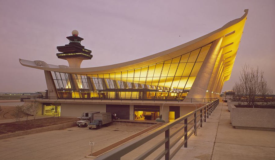
the original terminal at Dulles International Airport (IAD), before expansion in 1998-2000
Source: Library of Congress, Dulles International Airport, Chantilly, Virginia, 1958-63
Bi-County Parkway
The Bi-County Parkway is a road project championed by Virginia's Secretary of Transportation and supported by the Metropolitan Washington Airports Authority. It is a part of the $1.5 billion North-South Corridor, designed to link I-95 at Dumfries with Route 7 east of Leesburg.
Local and regional opposition to the project peaked in 2013. The alignment of advocates and opponents of the Bi-County Parkway demonstrated that even in the intense partisan climate of the day which blocked a budget bill and triggered a shutdown of the Federal government, local land use and transportation issues are based more on geographic and policy interests than on political party.
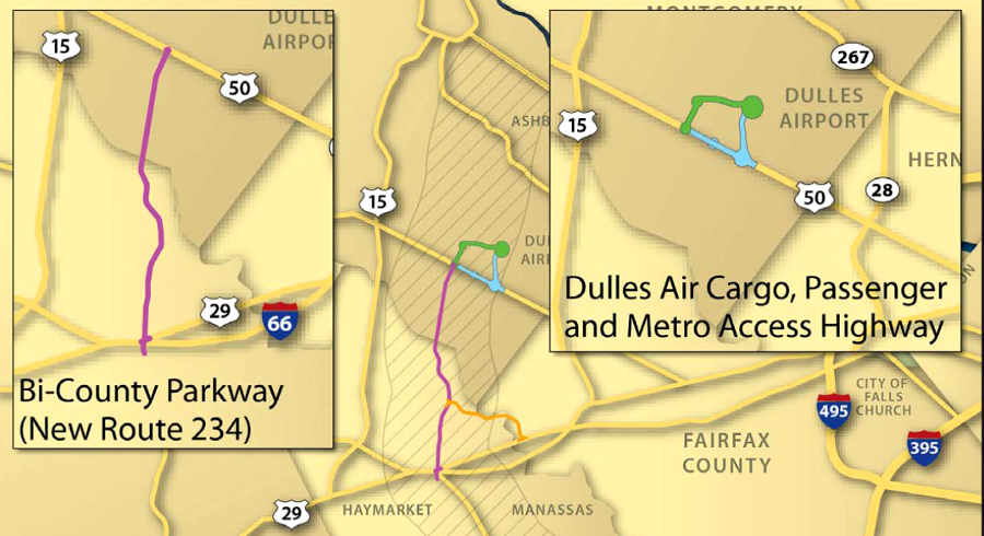
the Bi-County Parkway would link Prince William and Loudoun counties, while the Dulles Connector would provide a link to the airport
Source: Virginia Department of Transportation, Bi-County Parkway and Related Studies Prince William and Loudoun Counties (June 3, 2013)
The Chambers of Commerce in Prince William and Loudoun county supported construction of a new 10-mile road that would link I-66 with Route 50. Developers cited it as justification for increasing the number of houses they could build on parcels in western part of Loudoun County. The president of George Mason University claimed the road was essential for the success of the Prince William Campus. The Virginia Department of Transportation argued that improved road access to Dulles was essential for increasing cargo traffic and making the airport a hub for transporting more than just passengers. The airports authority supported the road because it would increase the value of 400 acres of airport property near Route 50 that was not needed for runway operations, but could be developed to generate revenue.3
The Bi-County Parkway would pave over four acres of Manassas National Battlefield Park and create noise and other impacts on the historic district, normally a reason for the National Park Service to object. Instead, the Federal agency pushed for the project, because opening the Bi-County Parkway would lead to closing Route 234 at the Stone House.
The road closure met half of the National Park Service's management goal to eliminate commuter traffic through the historic Civil War battlefield, so visitors could experience the historical setting without excessive traffic. The Federal agency understood that simply closing Route 234 was not possible unless an alternative route was provided. The National Park Service chose to sacrifice a few acres on the periphery of the 5,000-acre park's boundaries for a new road, in exchange for reducing traffic at the core of the park. (The agency had a similar strategy for closing Route 29 through the battlefield, by constructing a new bypass through Fairfax County on the northern side of Bull Run.)
Conservation-oriented groups that normally aligned with the National Park Service on land use issues, including the National Parks Conservation Association, came out in opposition to the new road. They argued that the project would expand suburban sprawl, rather than "smart growth" based on transit and walkable communities, resulting in unnecessary damage to streams and open space. Rather than spend money on a road running north-south, they offered an alternative set of projects that would improve the east-west commute from houses in western Loudoun/Prince William to the job centers in Tysons, Arlington, and DC.

the Bi-County Parkway, a part of the North-South Corridor, would address future growth of north-south traffic, not current east-west congestion
Source: Virginia Department of Transportation, Northern Virginia North-South Corridor
Neighbors who would be affected by the closure of Route 234 and impacts to adjacent roads were the leaders in the campaign to block the Bi-County Parkway. Their success in mobilizing the opposition demonstrated the old adage "politics makes strange bedfellows" is still true: numerous conservative Republican members of the General Assembly from the Northern Virginia region chose to oppose a road that was supported by the business community, a key source of their campaign contributions.
The Republican-controlled General Assembly had voted in 2013 for a significant tax increase, the first time the state had raised taxes for transportation projects since 1986. The Republican governor had signed the bill, despite opposition from "tea arty" conservatives. The conservatives were expecting the increased revenues to be used to solve well-known congestion problems, justifying their break with orthodoxy that new taxes were bad policy. The elected officials note the broad public opposition in the swing districts of suburban Virginia, and the Republican candidate for governor in 2013 shifted his position to directly oppose the project, saying:4
The argument advanced by the Virginia Department of Transportation (VDOT) was that the Bi-County Parkway was needed to "enhance the movement of people, passenger services and air cargo traffic to Dulles International Airport" quickly melted when scrutinized. A report by the Center of Regional Analysis at George Mason University noted that the potential to increase cargo traffic at Dulles was limited, and overall air cargo was declining as trucks, trains and ships compete for the business.
Dulles is a major destination for international passengers, but not a major destination for international cargo. Planes carrying passengers can also carry cargo, but just a small percentage of the plane is dedicated to cargo.
Passenger planes carry small amounts of cargo which companies like FedEx, UPS, and DHL then distribute. However, most air freight is carried in planes dedicated to only cargo. Improved ground transportation would have little impact in drawing all-cargo planes away from the two primary cargo airports on the East Coast, New York-JFK and Miami International Airport:5
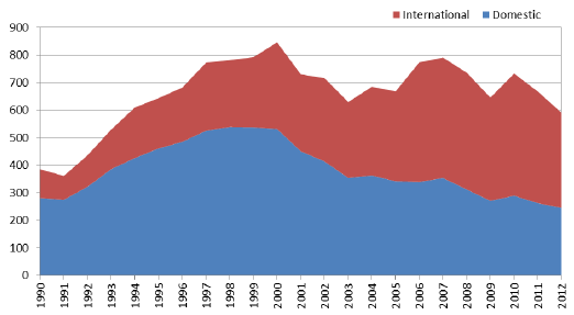
total cargo weight at Dulles, 1990-2012 (in millions of pounds)
Source: George Mason University Center for Regional Analysis, An Assessment of Factors Affecting Air Cargo Operations at Washington Dulles International Airport
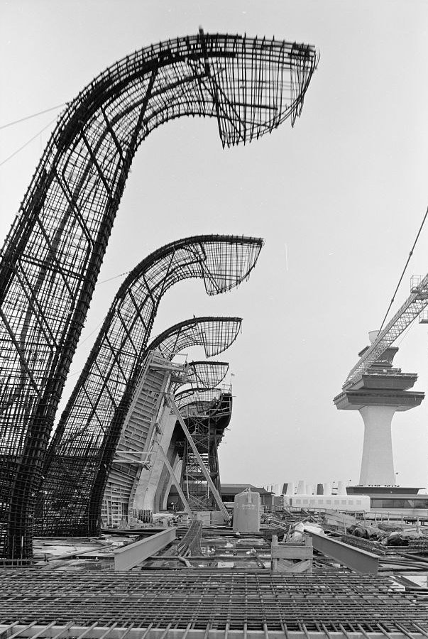
building Eero Saarinen's terminal at Dulles International Airport (IAD)
Source: Library of Congress, Dulles International Airport, Chantilly, Virginia, 1958-63