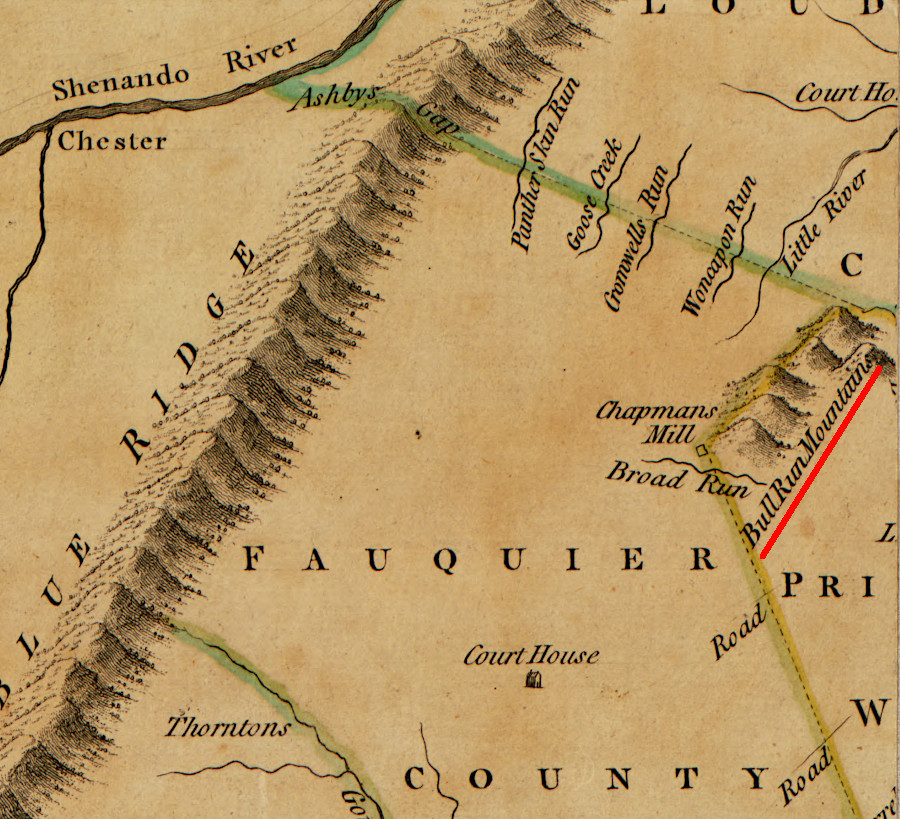
Throughfare Gap through the Bull Run Mountains has been a landmark ever since humans arrived in the area
Source: Library of Congress, A new and accurate map of Virginia (John Henry, 1770)
Throughfare Gap through the Bull Run Mountains has been a landmark ever since humans arrived in the area
Source: Library of Congress, A new and accurate map of Virginia (John Henry, 1770)
The 2,350 acres at the Bull Run Mountains Natural Area Preserve are managed by the Virginia Outdoors Foundation (VOF). The site was designated as a Natural Area Preserve in 2002.
The entire site is managed as a living laboratory, outdoor classroom, and open-air museum. Researchers have access to the northern part. Occasionally it is open to the school groups and the general public for scheduled hikes and other special events.
The preserve is still expanding. In 2025 the Virginia Outdoors Foundation acquired 178 acres that included the quartzite cliffs at High Point, which are highly visible to travelers on I-66 driving eastward in Fauquier County. The pine trees at High Point are table mountain pine, rare in Northern Virginia. Trails to High Point were closed around the time of COVID-19 to protect the fragile thin crust of vegetation on the bedrock.
As described by the Foundation:1
Bull Run Mountain is at the headwaters of Catharpin Creek and Bull Run; Bull Run defines the boundaries between Prince William County and Loudoun/Fairfax counties. That water ends up in the Occoquan Reservoir, which Fairfax Water uses as a major drinking water source. The highest quality water source to Bull Run is not the flow from the headwaters, however. The sewage which is treated and then discharged by the Upper Occoquan Service Authority into Bull Run is treated to drinking water standards before release.2
Since 2016, students in the Trout in the Classroom program have released their fry at Jackson Hollow. The potential to restore a self-sustaining brook trout in Catharpin Creek is very low outside of the protected area in the preserve. Residential development and farming has cleared the forest downstream. Even where trees on the streambank still provide shade, the creek gets too warm in the late summer. The water used by Trout in the Classroom students to raise eggs to the "alevin" stage before release is kept at 40-46°F.3
There are 10 natural communities identified at the preserve. The first ecological studies by scientists began in 1934, and there are still about 15,000 plant specimens from that time preserved by the Smithsonian Institution.
Land acquisition to conserve the acreage began in the 1960's, funded in part by local residents in Fauquier County. In the 1965 Virginia Outdoors Plan the Bull Run Mountains were proposed to become a new state park. The 1979 Virginia Outdoors Plan proposed designating the Bull Run Mountains as a State Natural Area, which would limit public visitation and prioritize conserving the natural setting. More botanical studies and an assessment of the timber rattlesnake (Crotalus horridus horridus) population on the mountain were completed in the 1980s. Various properties were transferred to the Virginia Outdoors Foundation, and the natural are preserve was dedicated in 2002.4
Public visitation was encourage by leasing 800 acres to the Friends of Bull Run in 1994. It owned the stone house at the end of Beverley Mill Road, and was supported by donors who also were preserving the adjacent Beverley-Chapman Mill.
Later, the Virginia Outdoors Foundation decided that the activities by educational classes within those acres, including the hiking trail to the top of High Point, were disturbing the natural setting and the lease was not renewed. The Friends of Bull Run transferred their educational efforts to Leopold's Preserve, a private conservation area nearby on the south side of I-66. The Virginia Outdoors Foundation also limited recreational use of the trails network within the preserve to just weekends.
In 2025, the Virginia Outdoors Foundation built a new parking lot and trailhead a mile away from the stone house. The project added another mile of trail (the "Blue Trail") to the existing seven mile network on the southern end of the preserve near I-66, and created a safer place to cross the Norfolk Southern railroad tracks. Public use is more restricted in the central and northern sections, permitted only on guided tours with are arranged regularly by the foundation.5
Source: Prince William County Office of Historic Preservation, 2023 Lecture Series: "Reconstructing an African American Neighborhood in the Bull Run Mountains"
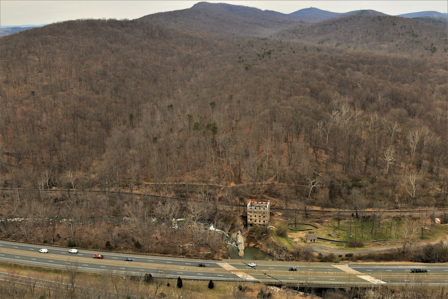
ruins of the Chapman/Beverley Mill lie between Bull Run Mountains Natural Area Preserve and I-66
Source: Historic Prince William, Chapman's Mill info - #94 (by David Cuff on March 29, 2019)