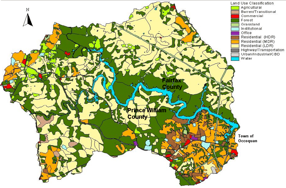
Occoquan land use - note how Fairfax border of reservoir is
"Forest" vs. "Residential" land use classification in Prince William
Source: Fairfax County Water Authority - Source Water Assessment Program Final Report (January, 2002)
The Recreational Water Use- Fairfax County Statement says it is not safe to touch the streams in the county: "In summary, any open, unprotected body of water is subject to pollution from indiscriminate dumping of litter and waste products, sewer line breaks and contamination from runoff of pesticides, herbicides, and waste from domestic and wildlife animals. Therefore, the use of streams for contact recreational purposes, such as swimming, wading, etc., which could cause ingestion of stream water or possible contamination of an open wound by stream water, should be avoided."
Bull Run drains into Occoquan Reservoir, but the county says that if it is not safe to go wading in Bull Run - don't touch the water. You might wonder... is it even safe to drink this water? Read:
NOTE: "TMDLs" are studies to determine the Total Maximum Daily Load of pollutants that a stream can absorb. In theory, scientists can use such studies to assess if a watershed is healthy, or overloaded by pollution. If overloaded, a TMDL can identify what sources of pollution are causing the problem.
Highest priority might not be forcing a factory to relocate in order to reduce potential toxic waste pollution, if the stream is currently overloaded with fecal coliform bacteria from old septic tanks that are leaking untreated human waste. Proposals to develop a complete set of TMDL's for every stream flowing into the Chesapeake Bay are controversial. Objections are that previous studies have documented what needs to be done to "save the bay," and delays to create more studies are... delays.
So yes, the Centreville restaurant supplied by Fairfax Water will provide you a glass of water that is safe to drink - because the "raw water" has been processed through the utility's drinking water treatment plants on the Potomac and Occoquan rivers.
The easiest way to minimize threats to human health and water treatment costs is to avoid polluting the water in the first place. The City of Manassas has essentially locked up its reservoir, shutting down a boat ramp and blocking all use by boaters and anglers.
This security may minimize the risk of terrorists somehow threatening the water supply. In the real world, it also reduces costs for the city. Manassas does not need to oversee a contract or provide staff to deal with litter, or ensure boats do not leak oil/gas into the drinking water. Still, the city has other threats to its water. Read:
Municipalities prefer to own the land on the shoreline of their own reservoirs. New York City went so far as to purchase much of the land in the Adirondack Mountains, and to impose land use restrictions that minimize sediment or pollution from entering its water supply.
Fairfax Water (the utility company that operates as an arm of county government) does not own the Occoquan watershed. It does owns an easement right on the edge of the water, allowing the utility to limit the development on the shoreline. It says, in part, "Removal of vegetation or trees located within the Easements, for purposes other than providing a walking path for Reservoir access as described in item d. is prohibited; the area within the Easements shall be left in its natural state." Even on the southern shoreline of the reservoir, the easement is enforced by Fairfax Water, not by Prince William County. The shoreline easement is not a county ordinance, enforced by county police. It is a deed restriction between two property owners, just like an easement your neighbor might have for a driveway across your land.

Occoquan land use - note how Fairfax border of reservoir is
"Forest" vs. "Residential" land use classification in Prince William
Source: Fairfax County Water Authority - Source Water Assessment Program
Final Report (January, 2002)
Fairfax County was able to minimize development along its shoreline, however. It partnered with the Northern Virginia Regional Park Authority to purchase much of the land adjacent to the reservoir, creating a large natural buffer that minimizes runoff into the reservoir and traps pollution. In contrast, Prince William County approved massive residential development next to the reservoir, especially the Lake Ridge community. Fairfax County had no authority to limit development south of its border. All Fairfax Water could do was study the rate at which silt filled the reservoir.
Fairfax County also restricted development on 41,000 of the 64,500 acres within the county that drain to the reservoir, by "down-zoning" the land. Before the zoning change in 1982, landowners were allowed to build roughly one home per acre. After the downzoning, development potential was limited to just one home per five acres. Landowners ended up with a high-value neighborhood of estate homes between Clifton and Route 123. To accommodate the reduced growth potential next to the reservoir, land around Centreville was upzoned to permit greater density. That's why townhome communities are concentrated north of Clifton, while the properties to the east look so different.
The county has also been a model for developing and implementing "Best Management Practives" (BMP's) for intercepting stormwater that rushes off impervious surfaces. Large and small stormwater ponds have been constructed to slow downm runoff, reducing the energy of stormwater that would otherwise scour sediment from stream banks. Read:

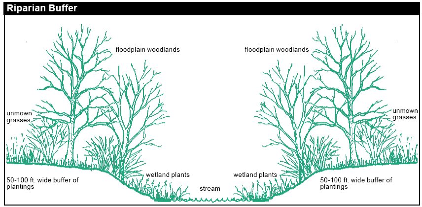
using natural vegetation to keep pollution out of streams costs less money than stormwater ponds
Source: Fairfax County - Beyond Your Backyard brochure