area moved from Loudoun to Fairfax in 1798 included lands between the mouths of Difficult Run and Sugarland Run (blue line is post-1798 boundary)
Source: ESRI, ArcGIS Online
When Fairfax County was created in 1742, the first courthouse was located near modern Tysons Corner. That explains why "Courthouse Road" is located in that area, far from the modern courthouse.
According to local lore, the site of executions for criminals in the 1700's was nearby. In the colonial era most capital crimes and executions were handled in Williamsburg, however, and pre-Civil war deeds do not refer to a Gallows Road. "Gallows Road" may have been named by a military mapmaker during the occupation of the area by the Union Army in 1861-65.1
In 1749, five years after Fairfax County was established, the colonial General Assembly chartered the town of Alexandria in Fairfax County and the town of Dumfries in Prince William County.
Both towns were sponsored by Scottish merchants and shared the same street names - King, Duke, Prince, etc. The Scottish merchants established commercial operations to buy tobacco in the colony of Virginia. Small farmers preferred immediate payment by the merchants in Virginia, rather than wait for payment after tobacco was shipped to England.
By paying for the tobacco directly, small farmers had the credit needed to purchase items immediately from the Scottish merchants' stores in Alexandria and Dumfries. This was a new business practice intended to compete with the traditional colonial pattern of consigning tobacco to agents in England.
Big planters like the Lees and Carters could afford to ship their tobacco across the Atlantic Ocean, even though their English agents sold the tobacco at what the Virginians often considered to be a bargain price. Along with the hogsheads of tobacco, the big planters sent orders for clothing, tools, wine, guns, and other items manufactured in Europe. The English agents purchased those items using the money from selling the tobacco, making a commission on the purchases as well. The big planters were accustomed to waiting up to a year to get their goods delivered, and many ended up going deep in debt by the time of the American Revolution.2
Alexandria quickly boomed as a seaport with direct connections to Europe. Shortly after its formation, the population of Alexandria had more political clout than the population in the western portion of Fairfax County. In 1752, when the 1742 courthouse needed to be replaced, the Alexandria merchants convinced county (and colonial officials in Williamsburg) to move the county seat to Alexandria. Naturally, residents in western Fairfax were disgruntled by the shift. They got a new Loudoun County created in 1757 with a courthouse in Leesburg, thus reducing the travel time required to go to the courthouse and transact business.
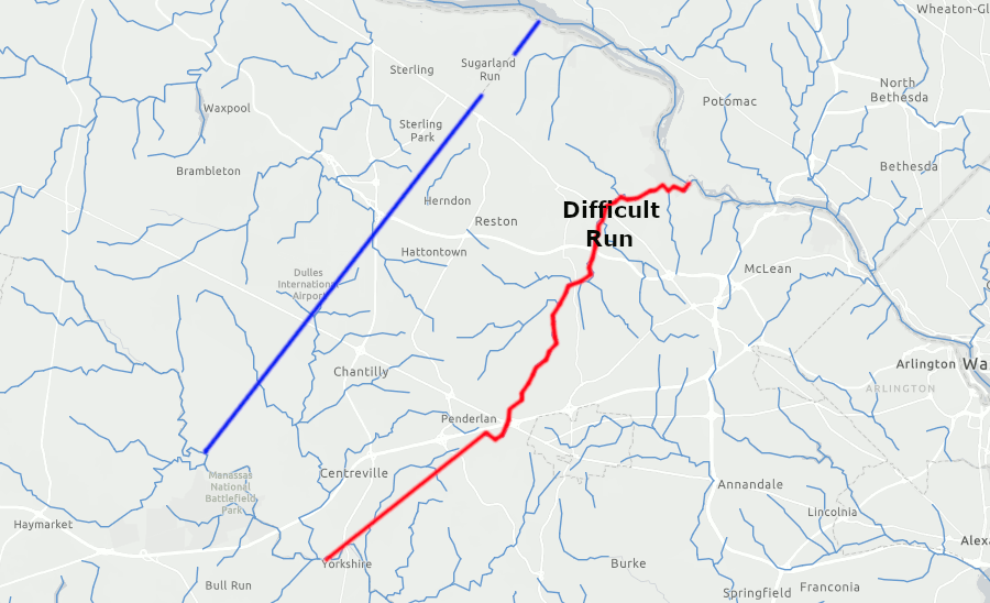
The eastern border of Loudoun County was defined by the headwaters of Difficult Run. From the mouth of that stream, a line was drawn south to the confluence of Cub Run and Bull Run, near modern-day Centreville.
The courthouse for Loudoun County was located at Leesburg, but the residents on the eastern edge of Loudoun County continued to do business in Alexandria. In 1798, a portion of eastern Loudoun County between Difficult Run and Sugarland Run was transferred back to Fairfax County. The new boundary was a straight line drawn southwest from the Potomac River to Bull Run. That line went between what is now the former mouth of Sugarland Run to the site of Carter's Mill on Bull Run.3
area moved from Loudoun to Fairfax in 1798 included lands between the mouths of Difficult Run and Sugarland Run (blue line is post-1798 boundary)
Source: ESRI, ArcGIS Online
Just two years later, the Fairfax County courthouse was moved 14 miles west to the new center of Fairfax County. That shift was necessary in 1800 because 32 square miles around Alexandria was ceded to the Federal government for inclusion within the District of Columbia. The Fairfax County courthouse could not stay in Alexandria, because it would have been located in a jurisdiction outside boundaries of the state of Virginia.
The new Fairfax County courthouse was built in the town of Providence. It was not possible to name that community "Fairfax" because the name was already used to designate the county seat of Culpeper County. Culpeper County was within the Fairfax Grant, and the Fairfax family had arranged for George Washington to be appointed as the surveyor of Culpeper County.
Culpeper County finally changed the name of its county seat in 1859. That allowed Fairfax County to designate its county seat as the Town of Fairfax, when that jurisdiction was incorporated in 1874.4
When the portion of the District of Columbia was "retroceded" or returned to the state of Virginia in 1847, the 32 square miles were not added back into Fairfax County. A new county was created, and Alexandria County built its own courthouse in the city of Alexandria. To reduce confusion between Alexandria County and Alexandria City, the county changed its name to Arlington County in 1920.
In 1961, when the Town of Fairfax became an independent city, Fairfax County had to prevent its courthouse from being located outside the jurisdiction of the county again. When the city boundaries were established, a small patch of land surrounding the county courthouse was excluded. As a result, there is a "hole in the doughnut" of Fairfax County land located inside the boundaries of the City of Fairfax. The historic and the current county courthouses, and some property next to the courthouses, still remain outside of the city boundaries.
Fairfax has built four courthouses - one at "Springfields" near Tysons Corner, one in Alexandria, and one in what is now a patch of county land surrounded by the City of Fairfax. The fourth courthouse is a modern building in the judicial center near the 1800 courthouse. When other county operations became too cramped in offices shared with the judicial center, Fairfax County built a new "Government Center" west of the courthouse near I-66. Most county staff moved to that location, except for those dealing with the court system.
Prince William County has a similar history. It has built five separate courthouses in different places as population centers have shifted. The Prince William County courthouse facilities are located within a small piece of county land surrounded by the City of Manassas, which became an independent jurisdiction in 1975. Most county offices are located at McCoart Administrative Center several miles to the east of the city, comparable to Government Center in Fairfax County.
In contrast, the county seat of Loudoun County has never moved since it was placed in Leesburg in 1757. Because Leesburg is a town and not a city, there is no "hole in the doughnut" pattern of boundaries. All of Leesburg is within Loudoun County, and not a separate jurisdiction.