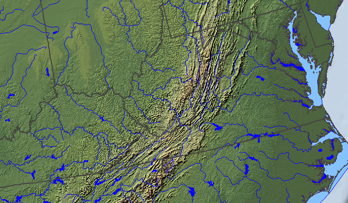
the first Virginian, when entering the state about 15,000-20,000 years ago, may have followed a river upstream before crossing the future border
Source: National Atlas
the first Virginian, when entering the state about 15,000-20,000 years ago, may have followed a river upstream before crossing the future border
Source: National Atlas
No one knows who was the first person to set foot into what is now Virginia, or when they got here.
We do know that the first Virginian was not a European who arrived in the 1500's. The Spaniards and English who attempted to colonize Virginia were late-comers.
Virginia Dare, born in 1587 at the new English settlement on Roanoke Island, was not the first girl born in Virginia. She was not even the first child born from European parents in North America. Spanish parents in St. Augustine welcomed Martin de Arguelles Jr. in 1566, and Snorri Thorfinnsson was born to Viking parents in Newfoundland over 500 years earlier.1
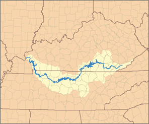
if the first Virginian walked up the Cumberland River, they may have passed through the Cumberland Gap to enter what is now Virginia
Source: Wikipedia, Cumberland River
The first Virginian had no concept they were crossing the boundaries of future political jurisdictions to arrive in Virginia perhaps 15,000-20,000 years ago. There was no grand entrance, and certainly no "Welcome to Virginia" sign. There was just one small step to cross a line that would be not be drawn until English kings made specific grants of land in 1632 (Maryland), 1663 (North Carolina), and 1681 (Pennsylvania/Delaware), or the US Congress accepted the Northwest Territory in 1784 and defined boundaries of new states in 1792 (Kentucky), 1796 (Tennessee), and 1863 (West Virginia).
Paleo-Indian foraging bands might have entered the state from the northwest, traveling eastward along the glacier's melting edge until crossing the Eastern Continental Divide to enter Virginia via the headwaters of the Potomac River. Hunters may have explored new territory by moving south along the Susquehanna River, reaching land that is now underneath the Chesapeake Bay.
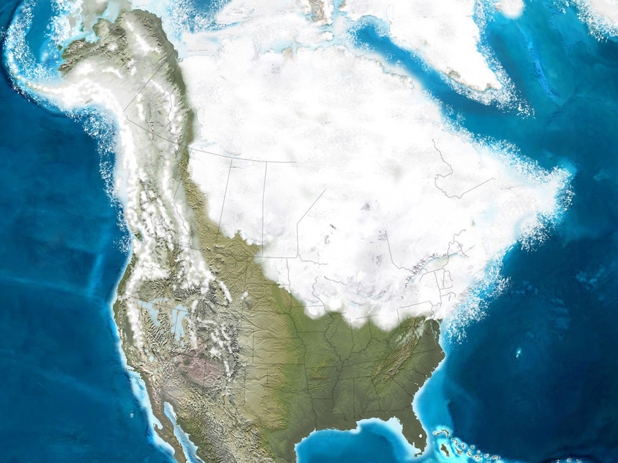
the first Virginian may have followed the Susquehanna River by traveling south, after moving east along the edge of the ice sheet
Source: National Oceanic and Atmospheric Administration (NOAA), North America
The hunting band probably included women and children in addition to men. Traditional speculation on gender roles assumes that physically-stronger men did the long-range scouting and hunting. and women gathered the plants and were primary caregivers for children. If so, then a woman - perhaps accompanied by one or more children - may have been the first person to cross into Virginia as she searched for new sources of food and medicine.
The first humans to enter Virginia may have originated from those who found the ice-free corridor between the Laurentide and Cordilleran ice sheets. The first immigrants into the interior of North America may have hunted large mammals (megafauna) migrating along the edge of retreating glaciers 18,000 years ago.2
Those humans would have seen massive rivers flowing south, creating major barriers to eastward migration. Perhaps the good habitat between the ice sheet and the Gulf of Mexico was occupied first, but people could have chosen to cross the frozen rivers during the winter and keep exploring towards the sun.
One river barrier was the Teays River. At its northern end, it was blocked by the ice sheet and carving a new channel now called the Ohio River. Hunting bands could have crossed a frozen Teays, then walked upstream along the Kanawha River. By paralleling the river, they would have reached the southern remnant of the ancient path of the Teays. Ironically, that ancient river channel is called the New River now. If the band continued moving upriver, the first Virginians could have entered Virginia at the edge of modern-day Giles County.
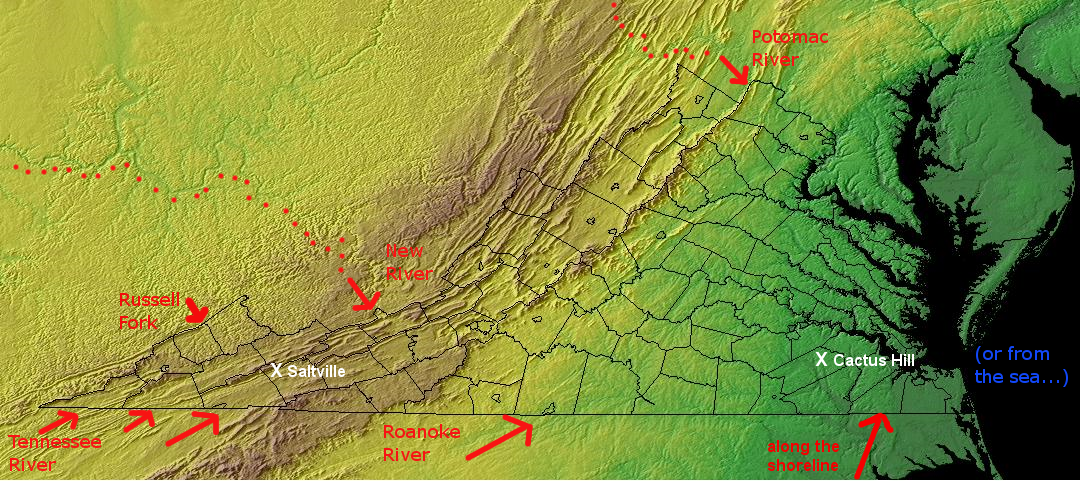
various paths the first human(s) may have taken to enter Virginia
Map source: National Oceanic and Atmospheric Administration (NOAA), Global Land One-km Base Elevation Project (GLOBE) database, Conterminous 48 USA states
Perhaps the first group to arrive followed a different tributary of the Ohio River further south. If they had walked along what today is called the Tennessee River, they would have entered Virginia's southern edge via the Powell, Clinch, or Holston rivers. If they chose the Cumberland River, the crossing could have been through the Cumberland Gap. In that case, the first use of the gap would have been a west-to-east trip, counter to the migration of settlers starting in the 1770's into Kentucky.
A hunting trip 15,000-20,000 years ago up the modern Big Sandy River could have led to a border crossing via the Russell Fork into Dickenson County at Breaks Interstate Park, via the Levisa Fork into Buchanan County, or via the Tug Fork and then Dry Fork into Tazewell County.
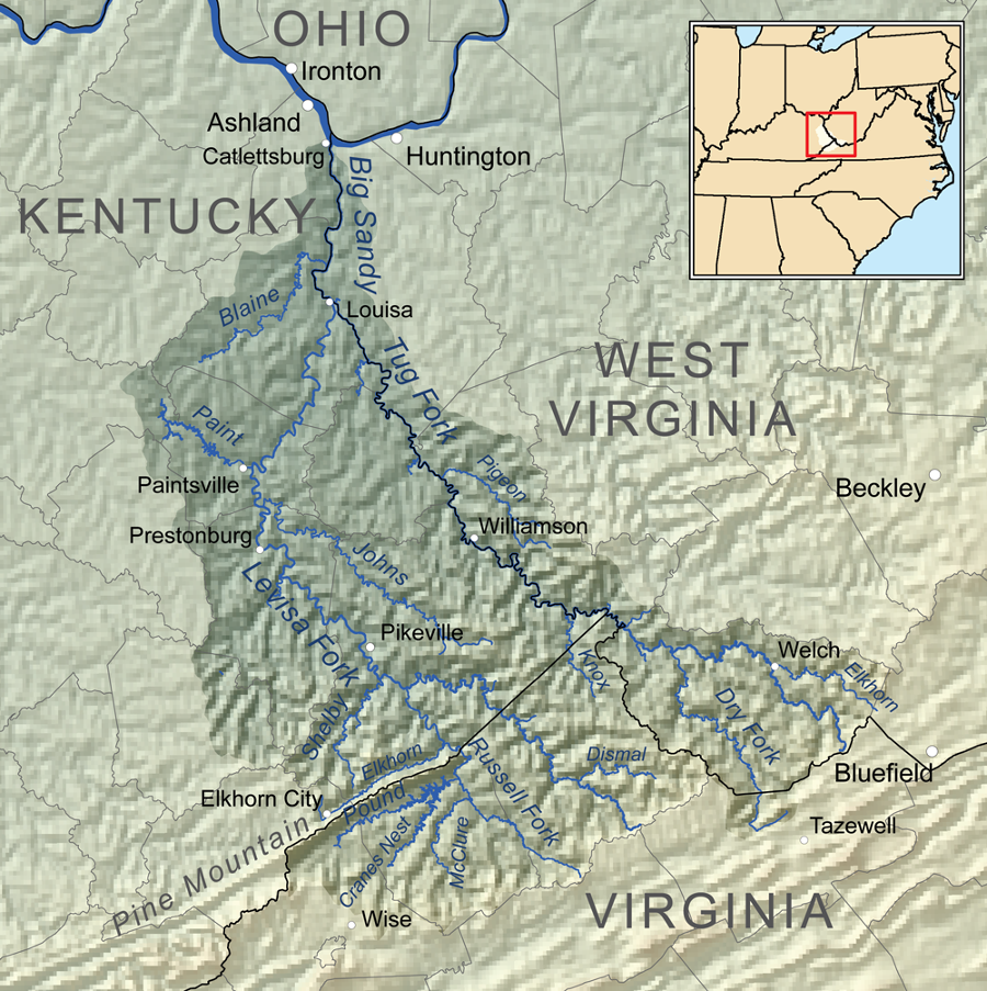
if the first Virginian walked up the Big Sandy River, they may have crossed the Appalachian Plateau 15,000-20,000 years ago to enter what is now Southwestern Virginia
Source: Wikipedia, Big Sandy River (Ohio River)
It is possible that the first humans to enter Virginia entered from the south, after following the "kelp highway" and feeding on seafood from Beringea down the Pacific Ocean coastline to Mexico. Of the many bands that headed inland, the first to reach the Gulf of Mexico shoreline may have crossed in Mexico.
It is logical to assume migration eastward along the shoreline, where food was readily available, would have been faster than migration inland and then eastward. Crossing the rivers discharging meltwater from the Laurentide Ice Sheet would have created delays. Walking across during a hard wintertime freeze might have been easier than building boats and dodging floating debris in the river currents.
Obviously the migrants succeeded in getting across the Mississippi River. Archeological evidence from Florida documents a Paleo-Indian meal from a mammoth completed 14,550 years ago, a thousand or so years before the Clovis culture emerged.3
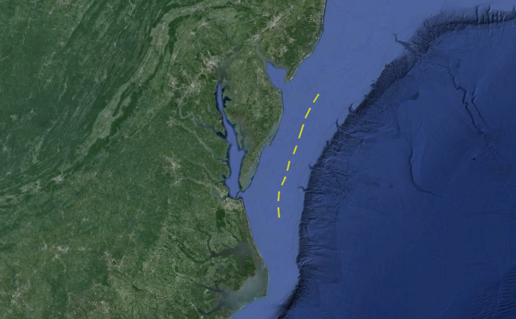
A group hunting and gathering food could have explored north from Florida, following the coastline. If so, they walked along the Coastal Plain into what today is the Outer Continental Shelf 70 miles off Virginia Beach. Sea levels were about 400 feet lower; the eastern edge of Virginia at that time is now close to the edge of the Continental Slope.
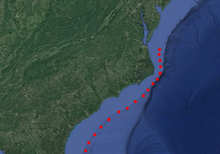
if the first Virginians followed the coastline north 15,000 years ago, then their campsites are 30-40 miles offshore and below 400' or so of water now
Source: Google Earth
The initial arrivals could have walked inland, moving through the forest and up what is now called the Chowan River before branching off to the north at the Nottoway or Meherrin rivers. That would match the location of the oldest documented site of Paleo-Indians within the modern boundaries of the state.
The oldest place known to have been occupied by prehistoric Virginians is the Cactus Hill site in Sussex County. Points, charcoal, stones and bone fragments discovered at Cactus Hill, a Late Pleistocene sand dune next to the Nottoway River, indicate humans were living there 18,000 years ago. The artifacts of "Blade People" may have been manufactured nearly 5,000 years before Clovis points were developed 13,500 years ago.
It is possible that the first Virginians at Cactus Hill died out, and the area was unpopulated for those 5,000 years until new immigrants arrived. The Clovis culture spread extremely rapidly across the continent within just 600 years, between 13,500–12,900 years ago. The first Virginians may have populated the region just as quickly, and could have disappeared equally fast.4
If the first Virginians had traveled even further upstream in the Roanoke River watershed, they would have crossed a future border between North Carolina-Virginia into modern Brunswick or Mecklenburg counties. Perhaps a group headed out of the river valley towards the setting sun, but ran into the Blue Ridge. The mountains could have diverted a group up the Dan River into Halifax County. Others may have walked up up the Ararat River into Patrick County.
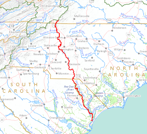
by walking over 350 miles upstream from the Atlantic Ocean via what is now called the Pee Dee River in South Carolina, the first group of Paleo-Indians could followed the Ararat River into Virginia 15,000-20,000 years ago
Source: US Geological Survey (USGS), National Atlas Streamer
One possibility: the first Virginians arrived as a family unit, traveling south along the Atlantic Ocean shoreline rather than following any river channel. A hunting band may have tired of trying to spear caribou or musk ox near the edge of the ice sheet, and ventured south along the Susquehanna River.
About 20,000 years ago, sea level was 400' lower due to the ice sheets. The Susquehanna River flowed down to modern Norfolk and then eastward; there was no Chesapeake Bay. The first Virginians would have walked on the exposed Coastal Plain, leaving footprints 40 or more miles east of the modern shoreline. If such a group had walked south along the shoreline, they would have crossed what is now the Outer Continental Shelf east of modern Accomack County on the Eastern Shore.
As an alternative scenario, perhaps the first Virginians followed the ocean shoreline north from Georgia through North Carolina, moving into what today is the Outer Coastal Plain east of Virginia Beach. Arrival on the Atlantic Ocean coastline would have marked the end of an out-of-Africa migration of Homo sapiens that started 40-70,000 years earlier.

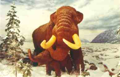
mammoth, with curved tusks vs. mastodon, with straighter tusks
Sources: Department of Energy
Lawrence Berkeley National Laboratory, US Geological Survey
The very first person was likely hunting or foraging along an inland stream valley such as the New River or the Atlantic Ocean shoreline, searching for plants, mushrooms, or new sources of stone for tools. Perhaps two people explored into what today is Virginia, then returned to their traveling group to bring back items of value and report on the feasibility of different routes of travel. Food may have been scarce in the headwaters of streams where watershed divides separate Virginia from Kentucky and West Virginia today, but rocks would have been more exposed. Paleo-Indians were expert geologists, and would have searched for rock formations that provided lithic resources for tool-making.
Intermittent forays by one-three people from a temporary base station could have been followed by a shift of that base, moving the entire band into future Virginia. Colonization would have occurred as different bands made intermittent forays and then moved their camps. The new settlers would have established patterns for hunting and gathering at productive locations they identified and re-visited. They would have encounter other bands, and "occupied" the new territory permanently. Species that were already established would have to adapt to the new predator, and those that failed to adapt quickly enough would be extirpated by excessive harvest.
At the time, the future boundaries of Virginia would have been 100% irrelevant.
The ancestors of the first people to arrive in Virginia may have come east from the Pacific coast in multiple waves, rather than one single migration past the ice barrier. Linguists who identify three major language groups in North America (First American, Eskimo/Aleut, and Na-Dene) suggest they reflect migrations at different times.
It is also possible that there were more than three major migrations, but some of the language groups brought via Beringia later died out. The land bridge to Asia disappeared beneath the rising waters of the Pacific Ocean and Arctic Ocean 11,600 years ago.5
The new immigrants into North American reached Monte Verde at the southern tip of Chile by 12,500 BCE (Before Common Era). It is possible that the migrating hunters and gatherers raced south, after emerging from thousands of years of isolation in Beringea 15,000 years ago, and got to the tip of South America in just 2,000 years.
As an alternative, maybe the first hunting bands arrived in North America around 20,000 years ago, bypassing ice sheets that closed off the land route at the peak of the Last Glacial Maximum. That scenario provides 2,000 years for humans to walk to Cactus Hill, on the banks of the Nottoway River in Virginia's Sussex County. An earlier arrival date would provide 5,000 years for humans to walk to Meadowcroft Rockshelter, southwest of Pittsburgh.
Archeologists have documented few camps of those Paleo-Indian wanderers. Population levels stayed very low, and no location was occupied long before the band moved on:6
The first Virginian may have come through Beringia and via the West Coast, but there is an alternative point of view. According to the Solutrean hypothesis, the first Virginian could have arrived from what is now France. They would have paddled a boat that crossed the northern rim of the Atlantic Ocean during the last ice age, hunting seals on the ice floes fringing the edge of the ice sheet that once covered the North Atlantic.
In 1974, 60 miles east of the shoreline:7
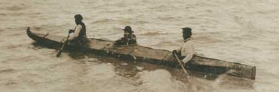
Alaska Bidarki or Skin Boat, ca. 1912
Source: National Park Service
On the other side of the North American continent, some paddlers from Siberia and Japan might have migrated across the Pacific Ocean at the edge of the ice, as the Laurentide Ice Sheet retreated and rising waters created the Bering Strait.
The Solutrean hypothesis is that European paddlers came across the Atlantic Ocean, seeking marine mammals and fish, and arrived in Virginia before anyone who had crossed the Bering Land Bridge also crossed the continent to reach the East Coast. That proposal, while intriguing, lacks supporting evidence. In particular, genetic research has failed to identify European ancestry in the Native Americans prior to the known arrival of Vikings and later sailors.8
if the Solutrean hypothesis is true and if humans arrived only 13,000 years ago, then the yellow line might be where the very first immigrants set foot in Virginia
Source: Google Earth
If the first Virginian crossed the modern state boundary at the Atlantic Ocean coastline, they did so before the ice sheets retreated into Canada. The first Virginian did not see the barrier island at Assateague, or the "Green Sea" marsh between the Back Bay and the Dismal Swamp.
If humans first settled Virginia near the maximum extent of the Wisconsin glaciation, there was no Eastern Shore, no Chesapeake Bay, no Virginia Beach. The James and Susquehanna rivers still flowed an additional 40-50 miles east across the Coastal Plain before reaching the Atlantic Ocean.
What today is the Outer Continental Shelf was covered with Ice Age forests and grasslands 15,000 years ago. The oldest evidence of human occupation in Virginia is probably buried below sediments 400 feet underwater, at the edge of the former coastline.9
Human migration across the North American continent may have required thousands of years. Small bands foraging for another meal would have been stressed physically, and women would have had low fertility rates. The average Paleo-Indian female may have died at 22 years of age.
When traveling into unknown territory where sources of reliable food were a mystery, the first Paleo-Indian bands would have been handicapped if they had a high percentage of children requiring care. Assuming the first humans in North America had low mobility and low fertility rates, with few children traveling in each band, population growth would have been slow. Equally likely, west-east expansion of the territory occupied by humans would have been slow.10
One can speculate that the first humans to reach Virginia arrived 2,000 years or more after the first humans to reach California. The members of the particular band that finally crossed into Virginia did not start on the edge of the Pacific Ocean and march 3,000 miles east. The first humans to cross the modern boundary of Virginia may have traveled less than 100 miles during their lifetime, before their search for food and lithics finally brought them across what would become a border defined much later by English colonists.
Migration further east was constrained by the ocean. What is now called Puerto Rico was not settled by humans until 700–400 BCE.
The first known individuals to make a complete trip across North America were the four survivors of the Panfilo de Narvaez expedition. In 1528, they landed at Tampa Bay in Florida. In 1536, three Spaniards - Cabeza de Vaca, Alonso del Castillo, and Andrés Dorantes, plus an enslaved Moor named Estevanico/Estevan, reached the Gulf of California. They finally encountered Spanish settlers when they reached the outpost of Culiacan, on the western side of Mexico.11
Over 300 Spaniards managed to travel from Tampa Bay to the east coast of Mexico in 1539-1543. They were the survivors of Hernando de Soto's expedition, which walked into what later became North Carolina before crossing the Blue Ridge. The Spanish built boats to sail down the Mississippi River and through the Gulf of Mexico to safety. They never traveled to the western edge of North America.12
The first citizens of the United States to cross the North American continent were led by Meriwether Lewis and William Clark in 1803-1806. An enslaved man, York, was also part of that expedition. Lewis and Clark started from Virginia in 1803, and reached the Pacific Ocean coastline in 1805. Lewis left Fort Clatsop in Oregon on March 23, 1806 and arrived back in Washington, DC in December 28, 1806. Clark arrived later in January, so Meriwether Lewis's 1806 cross-continental trip was both the first by a Virginia and the fastest in history at that time.13
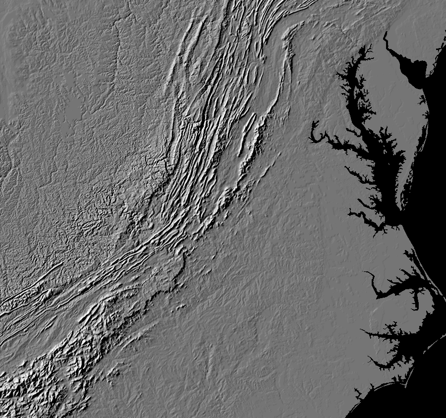
the first Virginian arrived before the Chesapeake Bay formed
Source: US Geological Survey, Landforms of the Conterminous United States - A Digital Shaded-Relief Portrayal (USGS Miscellaneous Investigations Series Map I-2206)
1. T. J. Oleson, "Snorri Thorfinnsson," in Dictionary of Canadian Biography, vol. 1, University of Toronto/University Laval, 2003, http://www.biographi.ca/en/bio/snorri_thorfinnsson_1E.html; "Firsts," Boca Raton News, July 4, 1971, http://news.google.com/newspapers?nid=1291&dat=19710704&id=5vdTAAAAIBAJ&sjid=KI0DAAAAIBAJ&pg=4179,227424 (last checked July 2, 2014)
2. "New Evidence Shows That Humans Could Have Migrated to the Americas Along the Coast," Smithsonian Magazine, June 7, 2018, https://www.smithsonianmag.com/smart-news/new-evidence-shows-first-americans-could-have-migrated-along-coast-180969217/ (last checked January 21, 2021)
3. Jessi J. Halligan, Michael R. Waters, Angelina Perrotti, Ivy J. Owens, Joshua M. Feinberg, Mark D. Bourne, Brendan Fenerty, Barbara Winsborough, David Carlson, Daniel C. Fisher, Thomas W. Stafford Jr, James S. Dunbar, "Pre-Clovis occupation 14,550 years ago at the Page-Ladson site, Florida, and the peopling of the Americas," Science Advances, Volume 2 No. 5 (May 6, 2016), http://advances.sciencemag.org/content/2/5/e1600375.full (last checked May 14, 2016)
4. Daniel P. Wagner and Joseph M. McAvoy, "Pedoarchaeology of Cactus Hill, a Sandy Paleoindian Site in Southeastern Virginia, U.S.A," Geoarcheology, Volume 19, Issue 4 (April 2004), pp.297-322; James K. Feathersa, Edward J. Rhodes, Sebastien Huot, Joseph M. Mcavoy, "Luminescence dating of sand deposits related to late Pleistocene human occupation at the Cactus Hill Site, Virginia, USA," Quaternary Geochronology, Volume 1, Issue 3, (August 2006), Pages 167-187, http://dx.doi.org/10.1016/j.quageo.2006.05.011; Michael F. Johnson, "Cactus Hill Archaeological Site," Encyclopedia Virginia, Virginia Foundation for the Humanities, October 5, 2016, https://www.encyclopediavirginia.org/Cactus_Hill_Archaeological_Site; Stuart Fiedel, "Rapid Clovis Colonization of the Americas: Chronological Evidence and Archaeological Analogues," Paleoamerican Origins: Beyond Clovis, A Peopling of the Americas Publication, 2004, p.97, p.100, https://www.researchgate.net/publication/292278543_Rapid_migrations_by_Arctic_hunting_peoples_Clovis_and_Thule
(last checked October 14, 2019)
5. David Reich et al., "Reconstructing Native American population history," Nature, July 11, 2012, http://www.nature.com/nature/journal/v488/n7411/full/nature11258.html; Lyle Campbell, American Indian Languages: The Historical Linguistics of Native America, Oxford University Press, 2000, p.98, https://books.google.com/books?id=h36tPYqAZPwC; "Deglaciation of North America,"
Museum of Archaeology & Ethnology, Simon Fraser University, https://www.sfu.ca/archaeology/museum/exhibits/virtual-exhibits/glacial-and-post-glacial-archaeology-of-north-america/deglaciation-of-north-america.html (last checked August 11, 2017)
6. Steven Mithen, After the Ice: A Global Human History, 20,000-5000BC, Harvard University Press, 2004, p.234, p.240-241
7. Bruce Bradley, Dennis Stanford, "The North Atlantic ice-edge corridor: a possible Palaeolithic route to the New World," World Archeology, Volume 36 (2004), https://doi.org/10.1080/0043824042000303656; Darrin Lowery, "The Challenge of Conducting Prehistoric Underwater Archaeology," Notes on Virginia 2009-2010, Virginia Department of Historic Resources, Number 53 (2009-2010), p.50, https://www.dhr.virginia.gov/pdf_files/notes_on_va/Notes_on_VA_2009_no.53.pdf (last checked August 31, 2023)
8. "Rejecting the Solutrean hypothesis: the first peoples in the Americas were not from Europe," The Guardian, February 21, 2018, https://www.theguardian.com/science/2018/feb/21/rejecting-the-solutrean-hypothesis-the-first-peoples-in-the-americas-were-not-from-europe; "Fisherman Pulls Up Beastly Evidence of Early Americans," Live Science, August 11, 2014, https://www.livescience.com/47289-mastodon-found-under-chesapeake-bay.html (last checked January 20, 2021)
9. "The Geology of Virginia - Coastal Plain Province," College of William & Mary Department of Geology, http://web.wm.edu/geology/virginia/provinces/coastalplain/coastal_plain.html; Wayne L. Newell, Inga Clark, and Owen Bricker, "Distribution of Holocene Sediment in Chesapeake Bay as Interpreted from Submarine Geomorphology of the Submerged Landforms, Selected Core Holes, Bridge Borings and Seismic Profiles," US Geological Survey Open-File Report 2004-1235, 2004, http://pubs.usgs.gov/of/2004/1235/ (last checked September 2, 2010)
10. Brett Reinhold Lenz, "Colonizer Geoarchaeology of the Pacific Northwest Region, North America" PhD thesis at the University of Leicester, June 2011, p.26, https://doi.org/10.978.164516/6573; Todd Surovell, "Early Paleoindian Women, Children, Mobility, and Fertility," American Antiquity, Volume 65, Number 3 (February 2000), http://www.doi.org/10.2307/2694532 (last checked September 4, 2022)
11. "The Narvaez Expedition," TexasCounties.net, http://www.texascounties.net/articles/discovery-of-texas/narvaezexpedition.htm; "Estevan – A Figure Of Myth & History," The Bryan Museum, https://thebryanmuseum.org/2020/06/15/estevan-an-early-african-in-the-new-world/; "New dating of cave art reveals history of Puerto Rican people," Phys.org, October 17, 2023, https://phys.org/news/2023-10-dating-cave-art-reveals-history.html (last checked October 18, 2023)
12. "The Survivors of the De Soto Expedition," National Park Service, http://npshistory.com/publications/deso/avellaneda/part1.htm (last checked September 5, 2022)
13. "Caroline historian leads effort to recognize York, sole enslaved member of Lewis & Clark expedition," Culpeper Star-Exponent, September 3, 2022, https://starexponent.com/news/national/caroline-historian-leads-effort-to-recognize-york-sole-enslaved-member-of-lewis-clark-expedition-copy/article_c11884db-23de-51f1-a8ec-5763d78529ab.html; "March 23, 1806," Journals of the Lewis and Clark Expedition, https://lewisandclarkjournals.unl.edu/item/lc.jrn.1806-03-23; "Captain Meriwether Lewis," Lewis and Clark Legacy Trail, https://valewisandclarklegacytrail.org/captain-meriwether-lewis/ (last checked September 4, 2022)