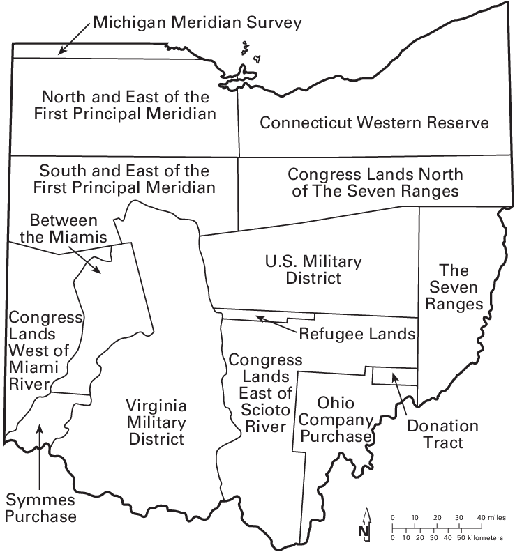
Virginia Military District - Ohio
Virginia retained land for fulfilling grants to its military veterans when ceding the Northwest Territory to the Continental Congress
Source: Perry-Castaneda Library Map Collection, The United States, 1783-1803 ("Historical Atlas" by William R. Shepherd, 1923)
The Continental Congress created a national army on June 14, 1775. Initially there was a wave of enthusiasm and volunteers quickly signed up. Two rifle companies in Virginia raced to Boston in the Beeline March in order to join the Army of Observation that had trapped the British inside the city.
By 1776, recruitment of officers and soldiers was difficult. Getting people to stay, rather than go home at the end of their enlistment period (typically between six months to three years), was also hard. Commanders in the Continental Army struggled to train, equip, and then keep soldiers in the field. Units would melt away when terms of enlistment finally expired, even if a battle was pending.
The Continental Congress recognized the need to encourage people to join the Continental Army and to stay. The delegates passed legislation in August 1776 to compensate those who were wounded and to compensate the widows of those who died from military action. The law authorized half pay pensions for life, or during disability for both officers and enlisted men. Pension promises were increased, as was the number of people eligible to receive a pension, throughout the war and then afterwards. The last pension act for Revolutionary War veterans and their widows was passed in 1878.
Land grants were also a major incentive. To get soldiers and their officers to serve for the duration of the war rather than just a fixed term, the Continental Congress authorized land bounties in its September 16, 1776 act. The acreage varied depending upon the rank at which one served, but an offer of 100 acres at the end of the war was sufficient to get attention from enlisted men and noncommissioned officers.
The Continental Congress also promised 50 acres to every "Hessian" soldier who deserted the British army. The British Army had the same approach when it started to expand beyond career soldiers in 1778, promising land bounties for three-year enlistments. Had the British defeated the isurrectionist colonists, land grants in the Ohio River watershed would have gone to a different group of English-speaking veterans. In the end, the British land grants were made for parcels in Ontario and Quebec, Canada.
Funding a national army was a major headache for the Continental Congress. By 1780 the currency issued by the nascent national government was almost valueless, "not worth a continental." Land was valuable, and land grants would incentivize enlistment.
Even though the Continental Congress owned no land, the representatives elected by 13 states still approved giving away acres in return for serving in the Continental Army. The members of the Continental Congress acted as land speculators. They gambled that the separate states with claims to land west of the Ohio River would eventually give that territory to the national government and that land could be used to fulfil the obligation to veterans. It was a good bet, fulfilled when Virginia formalized its cession of the Northwest Territory in 1784.1
There was an equivalent recruitment problem in the 13 separate states. Virginia had to draft soldiers to fill its quota of 15 regiments required by the Continental Congress to staff the Virginia Continental Line. Those soldiers who served in the Virginia Line of the Continental Army, after volunteering or being drafted, were promised a minimum of at least 100 acres of land in addition to the acres promised by the Continental Congress. Every state except New Hampshire, Rhode Island, Connecticut, New Jersey, and Delaware used land bounties to recruit soldiers during the American Revolution.2
Until the American Revolution, the separate and competing colonies assumed that they individually had the primary responsibility for defense on land against attacks by Native Americans and European rivals such as Spain and France. Cooperation between colonies in the French and Indian War was not sufficient, and they had declined to unite when assembled at Albany in 1754. Great Britain had to send troops across the Atlantic Ocean to defeat the French, starting in 1755.
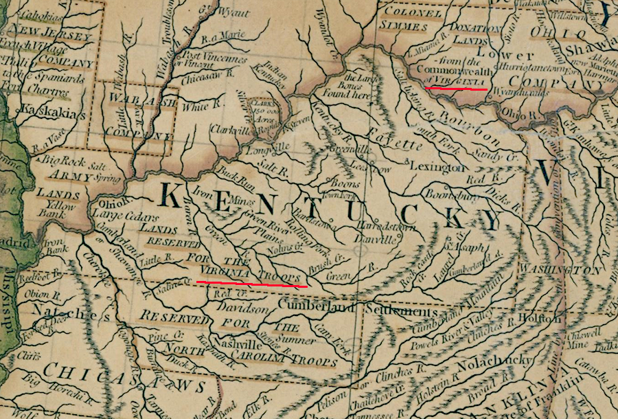
As the Revolutionary War continued and more soldiers from the rebelling 13 colonies were promised land grants, Virginia officials became concerned that the military district along the Green River in Kentucky might be too small to accommodate veterans from the French and Indian War and the American Revolution. State officials identified additional land, north of the Ohio River, to be reserved for military veterans to claim land. Before the Virginia General Assembly transferred its claim to the Northwest Territory north of the Ohio River, it reserved a district for veterans to acquire acreage based on their military service in the French and Indian War and the American Revolution.
Virginia officials eventually issued land warrants entitling Revolutionary War veterans to claim over 6.1 million acres in the two military districts in Kentucky and Ohio.3
Virginia reserved lands in the Northwest Territory and in Kentucky to provide land bounties promised to soldiers and officers
Source: National Archives, United States of North America with the British Territories and Those of Spain According to the Treaty of 1784 (1793)
Offering land along the Ohio River to entice soldiers to enlist began on February 19, 1754. At the start of the French and Indian War, Governor Dinwiddie issued a proclamation saying he was prepared to award 200,000 acres along the Ohio River to those willing to fight to capture Fort Duquesne and expel the French from the Ohio River Valley:4
- WHEREAS it is determined that a Fort be immediately built on the River Ohio, at the Fork of Monogahela, to oppose any further encouragements, or hostile attempts of the French and the Indians in their interest, and for the security and protection of his majesty's subjects in his colony; and as it is absolutely necessary that a sufficient force should be raised to erect and support the same; for an encouragement to all who shall voluntarily enter into the said service, I do hereby notify and promise, by and with the advice and consent of his majesty's council of this colony, that over and above their pay, two hundred thousand acres, of his majesty the king of Great Britain's lands, on the east side of the river Ohio, within this dominion, (one hundred thousand acres whereof to be contiguous to the said fort, and the other hundred thousand acres to be on, or near the river Ohio) shall be laid off and granted to such persons, who by their voluntary engagement and good behaviour in the said service, shall deserve the same.
After 1763, the Virginia colonial government issued warrants for surveys along the Ohio River to French and Indian War veterans. Claiming the bounty promised by Governor Dinwiddie and getting clear title to land was very complicated, in part because the Virginia-Pennsylvania boundary near the Forks of the Ohio was undefined. Multiple land companies, including the Ohio Company, also claimed the right to sell land in the same area. Converting a warrant into a patenbt (deed to the land) was blocked when the Proclamation of 1763 banned settlement west of the Appalachian Mountains.
The Treaty of Fort Stanwix loosened the constraints of the Proclamation of 1763, but officials in London never authorized sale of land west of the line established by the Proclamation of 1763. Colonial governments tried to ignore official royal policy, and both Pennsylvania and Virginia claimed they could issue patents around Pittsburgh.
One individual land speculator beat both the land companies and the colonies to the process of selling parcels of land at the Forks of the Ohio. George Crogan served as agent for William Johnson, the Superintendent of Indian Affairs for the Northern Colonies, and was able to navigate and manipulate relationships on the edge of colonial settlement. He manipulated his role as a go-between with the Haudenosaunee (Iroquois) and Pennsylvania colony and got three chiefs to award him 200,000 acres on August 2, 1749.
That deal was not legitimate according to British policy and was not recognized by Pennsylvania. Still, Crogan was willing to take risks. He calculated that in the confusion he could sell parcels anyway.
Like Crogan, many land hungry settlers were also willing to take risks. They ignored the constraints established by the Proclamation of 1763 and in the 1768 Treaty of Fort Stanwix. Many simply squatted on land, hoping to gain ownership later. In 1770, Crogan opened a personal land office in Pittsburg and announced he would guarantee the legitimacy of his sales. He sold land in parcels of just a few acres and as large as 20,000 acres.
Virginia's Governor Dunmore responded to Crogan's agressive actions and decided to sell up to 200,000 acres, as promised by Governor Dinwiddie in 1754 as land bounties for Virginians to enlist and fight in the French and Indian War. That required him to violate his directions from London, but would satify demands from members of the Governor's Council and leaders in the House of Burgesses.
George Washington was a leading advocate for the French and Indian War veterans. In 1754, he had ended up as Colonel of the Virginia Regiment. Washington was entitled to substantial acreage for service in that war. He had also purchased many of the sertificantes and warrants of individual soldiers and officers. They sold their rights to a land bounty because they preferred a quick payment (though at a significant discount) to waiting a long time for the legal opportunity to own the land.
Surveyor George Crawford had started to mark off tracts for Washington in 1772, even before Dunmore agreed to issue patents. Crawford identified choice parcels on the Monongahela River south of Pittsburgh and on the Great Kanawha River downstream, taking advantage of the relinquishment of that territory by the Haudenosaunee (Iroquois) in 1768.
In 1773 Governor Dunmore sent William Bullitt to survey parcels in Kentucky, on the south bank of the Ohio River opposite the Scioto River. The Shawnee were concentrated on the Scioto River, and did not accept that the assumption in the 1768 Treaty of Fort Stanwix that the Iroquois were entitled to grant their hunting territory to the British government. Crawford and Bullitt were not deterred by any Native American claims, and ignored the royal land grants claimed by the Ohio Company and other land speculaors to the same area.
In his surveys, Crawford identified the choicest lands for George Washington and other men of high social status and wealth who were claiming land based on service in the French and Indian War, or acquisition of warrants from those willing to sell their rights to acquire land in the future for ready cash. Parcels surveyed with lower-quality land were likely to be offered to the common soldiers.
The tracts Crawford defined were at times in conflict with boundaries already surveyed by Crogan. Crawford notified Washington in 1773 that he had marked off tracts so Washington and his friend Dr. James Craik would obtain the best bottomland, the flat territory with rich soil and waterfront access to the Great Kanawha River:5
- As to your Chance in your Lots of Land I think them much the best on the [w]hole River from one end of the Survays to the other, and those Gentlemen Seemd a good deel shagereend [chagrined] on the vewing them after there [their] Lots was Laid of[f], as there [their] front on the River was not over a Mile and half they most of them and Run back almost five mile and you in Chief of your Survays have all bottom as also Docter Crages Land none in that County is so good as your Land and his Land.
By the time the first Virginia Military District was established first in Kentucky, some French and Indian War soldiers and officers had already jumped the gun and sought to claim land on the Ohio River.
Virginia offered to cede the Northwest Territory to the new national government in 1781, and that offer helped convince Maryland to ratify the Articles of Confederation in 1782. The cession also acknowledged the impossibility of governing territory located so far away from Richmond, reduced concerns of other states that an oversized Virginia could dominate the coalition that had united to fight the British, and blocked efforts of various land companies to establish private claims in the area.
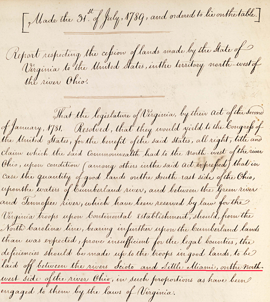
It took three years to complete the cession. Virginia's offer was contingent upon the Continental Congress guaranteeing Virginia's borders, including the state's right to retain Lincoln, Jefferson, and Fayette counties (now the state of Kentucky). Those counties south of the Ohio River had been created by subdividing Kentucky County in 1780. Congress finally accepted a revised offer from Virginia on March 1, 1784, tacitly confirming Virginia's western boundary along the Ohio River and including Kentucky.
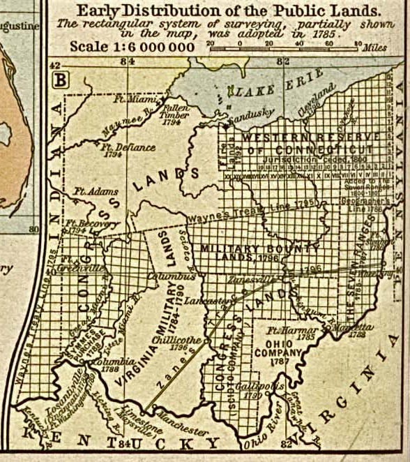
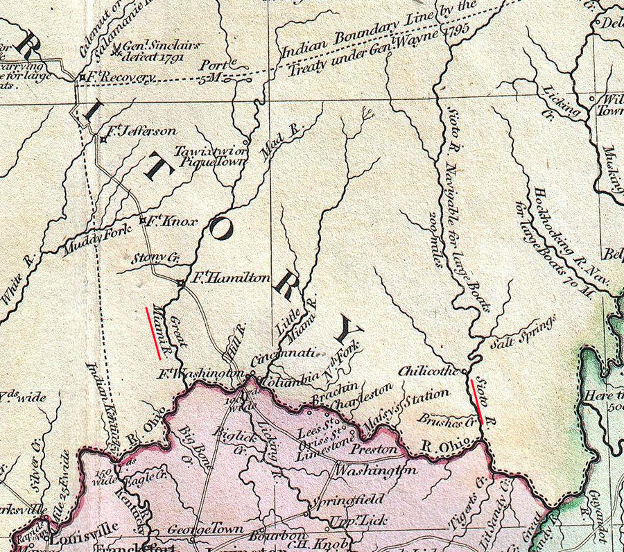
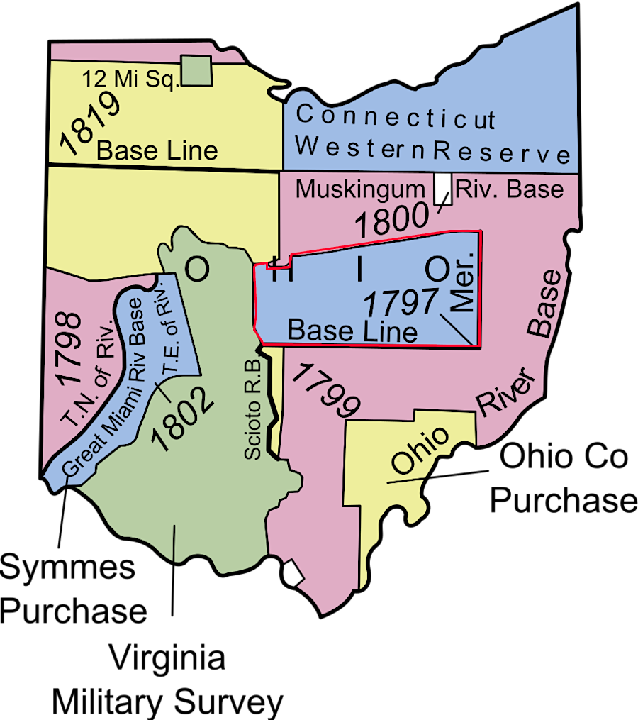
In the original 1781 offer and the final 1784 deal with the Continental Congress, Virginia retained rights to a military district totaling 4.2 million acres of land in what eventually became the state of Ohio. Virginia's General Assembly had promised land grants to soldiers willing to enlist in the Continental Army. The terms of the 1784 cession of the Northwest Territory ensured that Virginia would have enough land between the Scioto and Little Miami rivers, north of the Ohio River, to satisfy all soldiers and sailors making military service claims. The Land Ordinance of 1785 provided the framework for selling the land to settlers.
land between the Scioto and Little Miami rivers was reserved as the Virginia Military District
Source: Geographicus, A New Map of Part of the United States of North America, exhibiting The Western Territory, Kentucky, Pennsylvania, Maryland, Virginia & C (by John Cary, 1805)
Virginia was not the only state to create a military reserve before ceding western lands. North Carolina also defined the North Carolina Military District, in what became the state of Tennessee in 1796, for its veterans to claim their military land bounties.
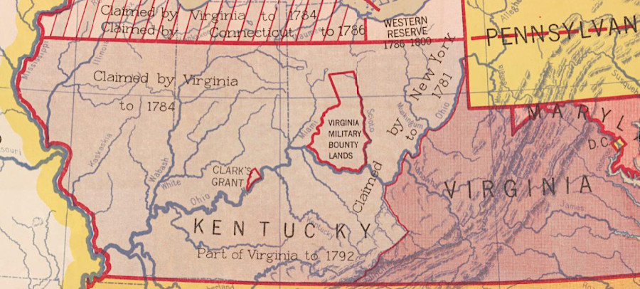
Massachusetts and Connecticut claimed that they, like Virgina, were entitled to portions of the Northwest Territory based on boundaries established in their colonial charters. New York claimed lands west of the Ohio River based on treaties with the Haudenosaunee Confederacy.
In the end, Massachusetts and New York abandoned their claims. Connecticut was able to get the Continental Congress to grant it a "Western Reserve" of land when the Northwest Ordinance was approved in 1787. Connecticut sold that 3.4 million acres; it was not used to fulfill grants of land promised to veterans who served in the Connecticut militia.
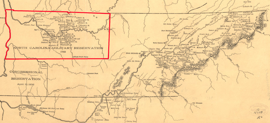
North Carolina also reserved territory for military land bounties before ceding its western claims to the Continental Congress
Source: Library of Congress, Aboriginal map of Tennessee (c.1886)
Only 35% of Virginia's Revolutionary War veterans who received warrants, and thus qualified for a land grant, had surveys done. Only 15% completed the process and received deeds (patents) for land. However, by 1790 there was little land left for veterans to claim in the Virginia Military District in Kentucky. Virginia opened its district in Ohio for land grants on August 10, 1790.
In the Virginia Military District on Ohio, over 16,000 surveys of parcels ended up being completed between the Scioto and Little Miami rivers. The land grants to veterans could be claimed by their heirs. Many acres ended up being transferred to creditors and land speculators who had acquired the "warrants" that established a veterans had a valid claim. The acreage in the Virginia Military District in Ohio fulfilled about 2/3 of all the land claims from Virginia veterans.
Richard Anderson, the Principal Surveyor appointed by the Virginia General Assembly, opened a land office near Louisville on July 20, 1784. He focused on the Virginia Military District in Kentucky first. Business was brisk.
Settlers judged the unforested acres (barren lands) in Kentucky to be unsuitable, thinking that grasslands reflected low soil fertility. When there was little "good" land remaining in the military land in Kentucky, Anderson authorized surveys north of the Ohio River starting on August 1, 1787. The first survey in the Virginia Military Reserve outside of Kentucky, in the in the Northwest Territory ceded by Virginia, was completed on November 13, 1787. However, the initial surveys were ultimately rejected.
The US Congress decided on July 17, 1788 that General Anderson had been premature in opening lands north of the Ohio River. The Federal government claimed that Virginia still had an adequate amount of land for veterans within the state's Kentucky reserve, and invalidated the surveys which Anderson had authorized in the Northwest Territory. The US Congress changed its mind on August 10, 1790. It declared that the land in the reservation south of the Cumberland River in Kentucky was exhausted, and permitted survey and patenting of parcels in Ohio.
The land office eventually moved from Louisville to Chillicothe, Ohio. That was a more convenient location to process surveys made within the Virginia Military District in Ohio.
Surveys in the Virginia Military District north of the Ohio River were done using Virginia's traditional metes and bounds approach. The rest of Ohio and the Northwest Territory was surveyed by the Federal government using the new rectangular Public Land Survey System. The Virginia approach, allowing land claims to be made before surveys and then using the metes and bounds technique, created overlaps and invited conflict between land claimants:6
- Because of the number of surveys and the difficulty of finding the physical objects they relied upon, this is probably the most litigated land area in Ohio.
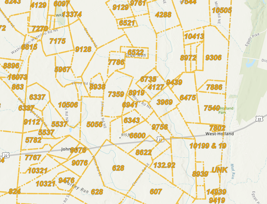
land patents in the Virginia Military District in Ohio were surveyed using metes and bounds, not the rectangular Public Land Survey System adopted by the Federal government
Source: Fayette County Ohio, Fayette County Ohio GIS Virginia Military Survey (VMS), Virginia Military District (VMD)
the Federal government completed multiple surveys to guide disposition of lands in Ohio
Source: Ohio Division of Geological Survey, Conversion of the Ohio oil- and gas-well township-location maps to a geographic information system: History and methodology
The land transfer process started with a veteran, or a person who had purchased or inherited the veteran's rights, obtaining a certificate proving their military service and then a warrant from a Virginia official for their claimed acreage. That warrant was delivered to the principal surveyor of the Virginia Military District in Ohio, who sent it to a deputy surveyor.
The deputy surveyor did the actual work, going out onto the ground and using the land measurement tools and techniques of the time to define the boundaries of a parcel matching the acreage in the warrant. Typically deputy surveyors were paid by being given with 20-50% percent of the land they surveyed, since cash was scarce. That form of payment incentivized surveyors to define tracts in what was expected to be high-quality farmland, and to bypass low-value hillsides and swamps.
Virginia allowed for surveys to exceed the authorized acreage in the warrant by 5%, but it was not uncommon for surveyors to measure even additional acreage. The excess land could be explained by the difficulties of crossing streams and forested ridges to maintain straight lines, but the surveyor also was paid by the applicant. It was always in the surveyor's interest to ensure that completed survey included as much land as possible.
The state of Virginia reviewed the survey documents. After validation, the state notified the Federal government and it issued the land patent (deed). The first legal land survey in Ohio was completed in 1787. The first patent for Virginia Military District land in Ohio was issued in 1796.
At times, fraudulent surveys were authorized. George Washington was entitled to 23,333 acres for his service in the French and Indian War and in the Revolutionary War, but he never claimed them. He did purchase two warrants issued to others for a total of 3,100 acres and had them surveyed in 1787. The US Congress nullified the surveys in 1788, but Washington assumed he still owned the rights to that acreage. However, "claim jumpers" filed new surveys in 1806 and acquired rights to his land, cheating Washington's heirs in the process.7
The Land Ordinance of 1785 reserved the 640 acres within Section 16 of each township so states could use the revenue from land sales there to fund educational institutions. There was no "Section 16" in the Virginia Military District, so acreage was identified outside the district to fund schools within it.8
There was a long delay between serving in the Continental Army and receiving a reward of land. Many soldiers sold to speculators their right to receive land that would be far to the west of their homes. Eventually 25 land speculators acquired over 1,000,000 acres of land within the Virginia Military District in Ohio.
By 1830, the owners of bounty rights to land within the Virginia Military District in Ohio struggled to identify parcels not already purchased or encumbered by legal clouds on the title. The US Congress authorized exchange of the warrants for script which entitled the holder to acquire land anywhere in the public domain. In 1850 the law was renewed. That was the same year in which California became a state, so the script could be used to acquire land there.
On December 9, 1852, Virginia transferred ownership of all remaining unclaimed land in the Virginia Military District in Ohio to the Federal government. In 1871, the Federal government transferred its ownership of that land to the State of Ohio.
The following year the state gave the land to the state university, enhancing the funding provided under the 1864 Morrill Act. Ohio State University ended up with almost 77,000 acres of free land within the Virginia Military District, but also with the administrative headache of clearing title until the last parcels were sold in the 1940's.9
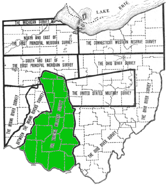
the Virginia Military District in Ohio was located between the Scioto and Little Miami rivers
Source: Ohio Lands and Their Subdivision, General Subdivisions of Land in Ohio (p.78)
The military districts established for Virginia veterans in Kentucky and Ohio are separate from a special 150,000 acre grant created for George Rogers Clark and his Illinois Regiment soldiers. Clark's Grant is now in Indiana, across the Ohio River from Louisville, Kentucky.
Clark's Grant, 150,000 acres rewarded to members of the members of George Rogers Clark's expedition that captured Vincennes in 1779, ended up in the state of Indiana
Source: Library of Congress, State claims, 1776-1802 (Hart-Bolton American history maps, 1917)
They districts reserved for Virginia are also distinct from the United States Military District in Ohio. At the end of the American Revolution, the Continental Congress was broke and unable to pay its soldiers. It offered land instead; soldiers had to accept warrants for acres rather than the cash payments they had been promised for each month of service.
The warrants could be converted into legal land titles only after getting parcels surveyed and going through various court procedures to validate ownership. Most soldiers sold their Continental Army warrants, like the bounties offered by Virginia, to land speculators.
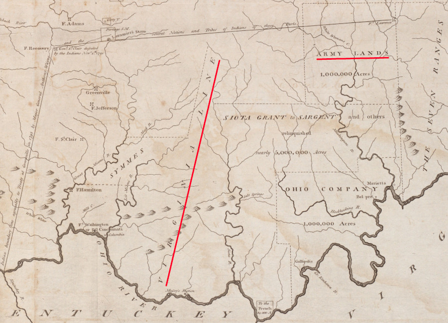
The Land Ordinance of 1785 established the US Military District in the Northwest Territory, with 2,560,000 acres within boundaries later defined by a special survey. Continental Army veterans, and the people who had acquired their warrants, were qualified to claim land within that district.
the United States Military District (red line) was created in the Land Ordinance of 1785
Source: Wikipedia, Northwest Territory
The United States government ended up issuing almost 11,000 warrants for over 1.5 million acres in the United States Military District. In 1796, the US Congress finally opened a land office in the US Military District to process veteran's claims to the land offered by the Continental Congress (separate from bounties also offered by the states). Until then, the only way for soldiers to generate revenue from their Continental Congress bounty was to sell their rights to two land speculators who had purchased large tracts in Ohio from the Federal government.
The Ohio Company and John Cleves Symmes were allowed to use Continental Army warrants as payment for those lands, which were separate from the US Military Reserve. The speculators purchased veteran's claims at a discount, then used them rather than cash to pay for land - which they then sold at market prices. 90% of Continental Army veterans who completed the paperwork required to establish their land claim ended up selling their warrant to someone else.
During the War of 1812, the US Congress offered lands again to recruit soldiers. Federal military reserves were set up in Illinois, Arkansas, and Missouri. Land grants were last used to recruit soldiers in the Mexican War. The 1862 Homestead Act, passed during the Civil War, made it possible for anyone to claim public domain land for free just by settling on it; no military service was required.
In 1842, the US Congress allowed military land warrants to be used to purchase any public domain land:10
- More warrants were used in Iowa than in any other state, and it is estimated that half of Iowa was purchased with bounty-land warrants.
In 1852, Virginia stopped awarding land in its Ohio or Kentucky military districts. Descendants of Revolutionary War veterans who had enlisted in Virginia, and who were seeking to redeem a warrant issued as a state bounty for enlisting in the Continental Army, had to exchange that warrant for Federal script. That script could be redeemed for vacant Federal land anywhere within the United States.11
Links
two districts with lands for military veterans were established in the Land Ordinance of 1785
Source: Leventhal Map Collection, Boston Public Library, A map of part of the N:W: Territory of the United States: compiled from actual surveys, and the best information (by Samuel Lewis, 1800)
References
1. Will Graves, "Pension Acts: An Overview of Revolutionary War Pension and Bounty Land Legislation and the Southern Campaigns Pension Transcription Project," March 28, 2017, https://revwarapps.org/revwar-pension-acts.htm (last checked June 15, 2025)
2. "Virginia Revolutionary War Service Records," Library of Virginia," https://lva-virginia.libguides.com/revolutionary-war; "Military Bound Land," RootsWeb, https://wiki.rootsweb.com/wiki/index.php/Military_Bound_Land (last checked July 5, 2025)
3. Thomas E. Ferguson, "Ohio lands a short history," Ohio Auditor of State, 1994, p.4, https://ohiomemory.org/digital/collection/p16007coll109/id/3059 (last checked June 10, 2025)
4. "Governor Robert Dinwiddie's Proclamation Of 1754," Kentucky Secretary of State, https://www.sos.ky.gov/land/resources/legislation/Documents/Proclamation%20of%201754.pdf (last checked July 1, 2025)
5. George Crogan: Wilderness Diplomat, Nicholas B. Wainwright, University of North Carolina Press, 1959, p.28, https://archive.org/details/georgecroghanwil0000wain/page/28/mode/2up; Eric Hinderaker, Elusive Empires: Constructing Colonialism in the Ohio Valley, 1673-1800, Cambridge University Press, 1999, pp.171-173, https://www.google.com/books/edition/Elusive_Empires/phuMw_zF4-sC; "To George Washington from William Crawford, 12 November 1773," Founders Online, National Archives, https://founders.archives.gov/documents/Washington/02-09-02-0287 (last checked July 5, 2025)
6. Thomas E. Ferguson, "Ohio lands a short history," Ohio Auditor of State, 1994, pp.4-5, https://ohiomemory.org/digital/collection/p16007coll109/id/3059; "Early North Carolina / Tennessee Land Grants at the Tennessee State Library and Archives," Tennessee Secretary of State, https://sos.tn.gov/tsla/guides/early-north-carolina-tennessee-land-grants-at-the-tennessee-state-library-and-archives; "Western Reserve," Encyclopedia of Cleveland History, https://case.edu/ech/articles/w/western-reserve; Harriet Taylor Upton, History of the Western Reserve, Volume 1, 1910, pp.10-11, https://www.google.com/books/edition/History_of_the_Western_Reserve/xEsbLFoBttYC; "Description of the Different Land Grants of the State of Ohio," Illustrated atlas of Guernsey County, Ohio, 1902, https://lccn.loc.gov/2007626975; "The land on which Dublin was settled is part of the territory once claimed by the Colony of Virginia. Read how the land was granted to those who fought for Virginia in the War for Independence and read the letter, or “patent” from President Thomas Jefferson to Lieutenant James Holt granting him land in the vicinity of Dublin," Dublin Historical Society, https://dublinohiohistory.org/history/dublin-stories/virginia-military-district/; "Highland, other counties came from Virginia Military District," Times-Gazette, July 26, 2016, https://www.timesgazette.com/2016/07/26/highland-other-counties-came-from-virginia-military-district/; "Anderson, Richard Clough. Papers, Ohio Manuscripts, 1782-1905, 1912-1914," University of Illinois Library, https://archon.library.illinois.edu/ihlc/index.php?p=collections/controlcard&id=425; "Military Bound Land," RootsWeb, https://wiki.rootsweb.com/wiki/index.php/Military_Bound_Land; Nelson Wiley Evans, A history of Adams County, Ohio, 1900, pp.39-40, https://archive.org/details/ahistoryadamsco01stivgoog; "Northwest Ordinance (1787)," National Archives, https://www.archives.gov/milestone-documents/northwest-ordinance (last checked July 5, 2025)
7. Thomas E. Ferguson, "Ohio lands a short history," Ohio Auditor of State, 1994, pp.4-5, https://ohiomemory.org/digital/collection/p16007coll109/id/3059 (last checked June 10, 2025)
8. Thomas E. Ferguson, "Ohio lands a short history," Ohio Auditor of State, 1994, p.35, https://ohiomemory.org/digital/collection/p16007coll109/id/3059 (last checked June 10, 2025)
9. Thomas E. Ferguson, "Ohio lands a short history," Ohio Auditor of State, 1994, p.8, https://ohiomemory.org/digital/collection/p16007coll109/id/3059 (last checked June 10, 2025)
10. "Military Bound Land," RootsWeb, https://wiki.rootsweb.com/wiki/index.php/Military_Bound_Land; Thomas E. Ferguson, "Ohio lands a short history," Ohio Auditor of State, 1994, pp.23-24, https://ohiomemory.org/digital/collection/p16007coll109/id/3059; "Continental Congress: Offer of Religious Freedom to Hessians Who Deserted Great Britain's Army," Free Speech Center, Middle Tennessee State University, February 7, 2025, https://firstamendment.mtsu.edu/article/continental-congress-offer-of-religious-freedom-to-hessians-who-deserted-great-britains-army/; Benjamin Horace Hibbard, A History of the Public Land Policies, 1924, p.122, https://digital.library.cornell.edu/catalog/chla3069379 (last checked January 12, 2025)
11. "Revolutionary War Bounty Land Claims," Library of Virginia, /a> (last checked December 12, 2025)
a 1789 US Congress report documented the location of the Virginia Military Reserve in Ohio
Source: Library of Congress, Cession of Lands from Virginia to the United States
The Military in Virginia
Virginia Places