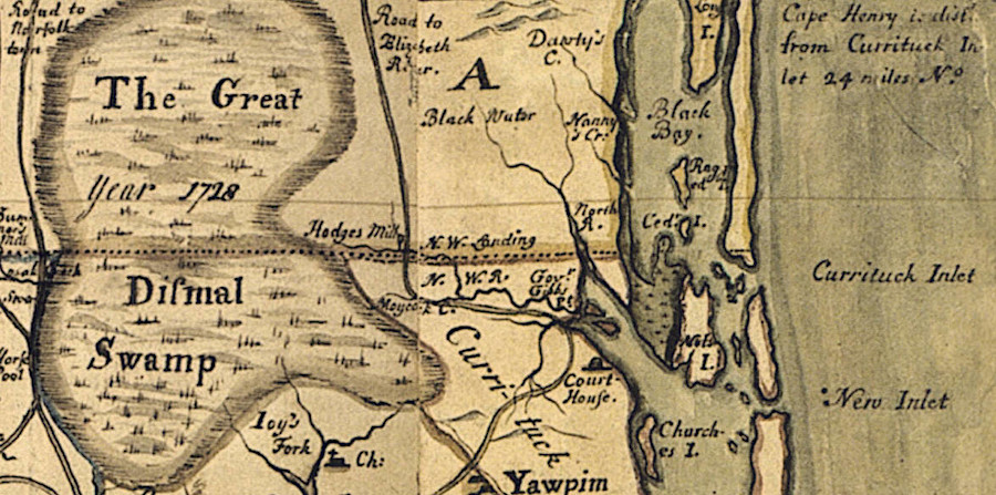
the Carolina surveyors of the 1728 Dividing Line identified the boundary as starting north of the Currituck Inlet
Source: East Carolina University, A New and Correct Map of the Province of North Carolina (by Edward Moseley, 1733)
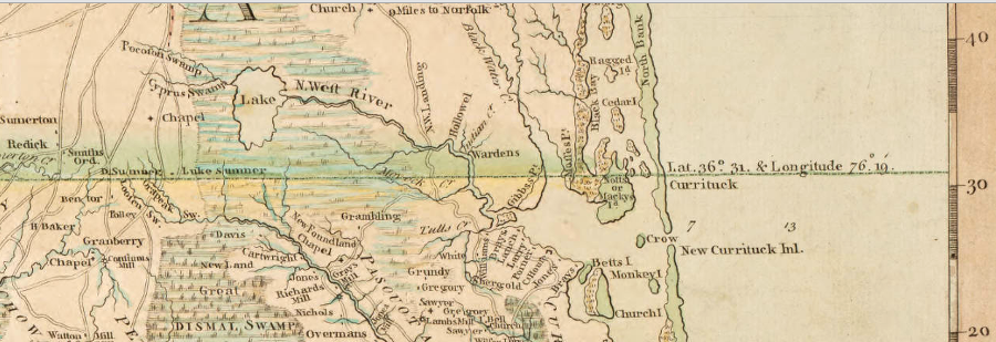
the Carolina surveyors of the 1728 Dividing Line identified the boundary as starting north of the Currituck Inlet
Source: East Carolina University, A New and Correct Map of the Province of North Carolina (by Edward Moseley, 1733)
The far eastern boundary of Virginia-North Carolina, running in the opposite direction from the boundary survey of 1728, extends into the Atlantic Ocean for three miles offshore.
Under Federal law defining control of the Outer Continental Shelf, each state owns the bottom of the Atlantic Ocean for three miles off the shoreline (measured from the Mean Lower Low Water line). Both the North Carolina and Virginia constitutions define the boundary to be a straight line east of the location where surveyors placed a cedar post in 1728:1
Beyond the three mile line of state control, the Federal government manages both the seabed and the fishery resources out to the edge of the Exclusive Economic Zone (EEZ) 200 miles from the shoreline.
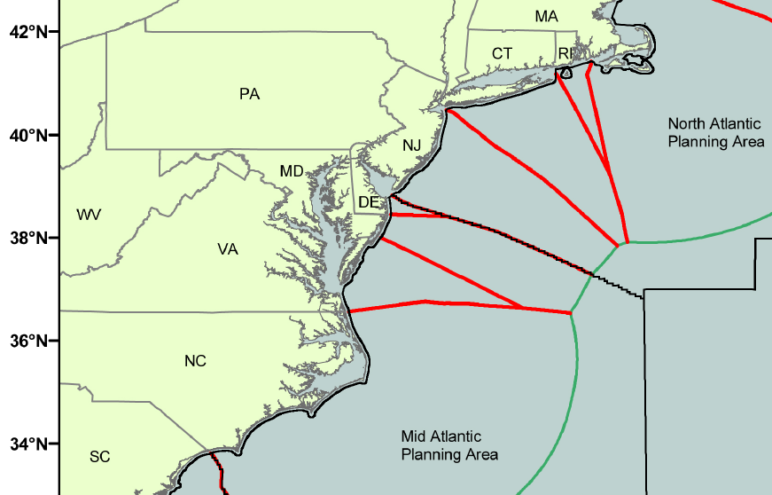
An east-west line based on the Virginia and North Carolina boundary is used to define the administrative regions of the South Atlantic Fishery Management Council and the Mid-Atlantic Fishery Management Council. Those are two of the eight regional fishery management councils established by the Federal government in 1976, when Congress extended the U.S. jurisdiction of fisheries throughout the Exclusive Economic Zone.2

an eastern extension of the Virginia-North Carolina boundary divides the management areas of the South Atlantic Fishery Management Council from the Mid-Atlantic Fishery Management Council
Source: South Atlantic Fishery Management Council, outer boundaries of the Exclusive Economic Zone (EEZ) off the southeastern coast
The Federal government owns the ocean bottom east of the three mile offshore boundary, going out to a point 200 miles to the edge of the Exclusive Economic Zone (EEZ). Federal agencies manage oil/gas, windpower, and seabed mining leases on the Outer Continental Shelf beyond the three mile boundary.
In 1986, Congress established a Revenue Sharing Boundary through amendments in section 8(g) of the Outer Continental Shelf Lands Act. The 8(g) boundary gave Virginia and other coastal states outside the Gulf of Mexico 27% of revenues from oil/gas and offshore wind turbine leases, but only in a zone extending three miles seaward further past state waters (i.e., between 3-6 miles off the coastline).
Distribution of revenues from Federal leases from the seabed, in the 8(g) zone and even further beyond the seaward jurisdictional limit of Virginia, could be based on Administrative Boundaries that are defined by the Bureau of Ocean Energy Management (BOEM). The BOEM, a part of the US Department of the Interior, drew the Administrative Boundaries based on the National Baseline, which is the shoreline location created by the National Oceanic and Atmospheric Administration (NOAA).
The Administrative Boundaries extending beyond the seaward jurisdictional limit of Virginia are more than just a quirk of bureaucratic cartography. The Federal government could use the Administrative Boundaries to define how much each state might receive under the 8(g) revenue sharing provision, or a possible expansion of revenues from offshore leases. Gulf Coast states receive 37.5% of offshore energy revenues, providing millions of dollars to state governments.
one early (1770) map defined a colonial boundary extending into the Atlantic Ocean
Source: North Carolina Collection at the University of North Carolina at Chapel Hill, A Compleat map of North-Carolina from an actual survey (1770 map by John Collet)
If the Congress granted the southeastern states 37.5% of offshore energy revenues, and if the Administrative Boundaries were used to allocate the revenues from different oil and gas platforms, then North Carolina could receive substantial revenue from leases located in waters east of Virginia Beach and north of a straight-to-the-east extension of the Virginia-North Carolina boundary on land.
That possibility existed because the National Baseline is not an east-west line drawn perpendicular to the coast from the point where that cedar post was planted in 1728.
The National Baseline is determined by using the Mean Lower Low Water (MLLW) line on NOAA's nautical charts, plus straight lines drawn across indentations such as bays and river mouths. The Administrative Boundary lines used by the Federal government are drawn mathematically so points in the ocean will be equidistant from the nearest points on the National Baseline.3
Because the Virginia shoreline does not run exactly north-south, the Administrative Boundaries separating Virginia and North Carolina do not run exactly east-west. The line defining the boundary between Virginia and North Carolina slopes slightly to the northeast, and some of the Federal waters east of Virginia Beach are associated with North Carolina.
though the extension of the state boundary into the Atlantic Ocean may go directly east-west, the Federal Outer Continental Shelf (OCS) Administrative Boundaries are based on the principle of equidistance
Source: Bureau of Ocean Energy Management, Federal Outer Continental Shelf (OCS) Administrative Boundaries
Plans for offshore oil and gas Sale 220 were cancelled before any areas were leased, after the Deepwater Horizon well in the Gulf of Mexico disaster in 2010 created a massive oil spill.
President Obama's administration prepared a new Five Year Plan in 2016 to lease Federal submerged lands off the southeastern states. Virginia's two senators supported legislation that would give coastal states 37.5% of revenues from future offshore leases, and would ensure all southeastern states received a share no matter where new wells might be located.
A senator from Florida, opposed to offshore drilling on the Atlantic Ocean side of that state, blocked action. Unless Congress passes new legislation, the line where Virginia can exert any state claim for revenue will continue to be the 8(g) boundary 6 miles offshore. It will not matter how the Federal government draws any lines in the Atlantic Ocean east of the 8(g) line to distinguish Virginia from North Carolina.4
The second Trump Administration opposed offshore wind along with other renewable energy projects. It rescinded designation of Wind Energy Areas at the end of July, 2025, eliminating the potential for development of Dominion Energy's Coastal Virginia Offshore Wind (CVOW)-South (formerly known as Kitty Hawk North Wind) project.5
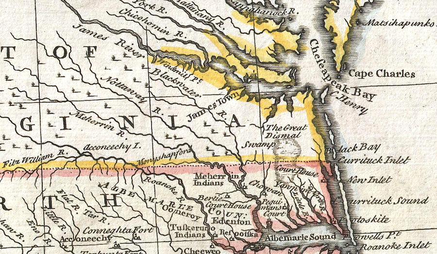
colonial boundaries separating Virginia and North Carolina focused on the land, not the Atlantic Ocean
Source: Emmanuel Bowen, A complete system of geography (1747 map posted with Wikipedia article "Royal Colonial Boundary of 1665")