Piscataway/Conoy in Virginia
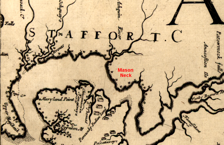
a 1670 map recorded settlements of the Piscataway and remnants of the tribes in Powhatan's paramount chiefdom, across the Potomac River from the Occoquan River
Source: Library of Congress, Virginia and Maryland as it is planted and inhabited this present year 1670 (by Augustine Herrman)
When the English arrived in Virginia, there were roughly 5,000 members of the Piscataway nation living between the western shore of the Chesapeake Bay and the Potomac River. They were organized as a paramount chiefdom with a paramount chief similar to Powhatan, known as the tayac.
Towns were surrounded by wooden palisades. Those labor-intensive structures were necessary, as was the alliance among the tayac's tribes, because raids from the Iroquois, Susquehannocks, and Powhatans were a constant threat. Conflict was common long before European colonists arrived.
The tayac's span of control included what today is southern Maryland west of the Chesapeake Bay, stretching to the Potomac River. Land on the west side of the Potomac River was occupied by the Moyumpse (Dogue), and appears to have been part of the tayac's territory as well. Each town under his authority was governed by weroances, war chiefs, priests and shamans.
The tayac's capital was at Moyaone near Piscataway Creek. People had lived there for 15,000 years. When they first arrived, there were rich wetlands along the water's edge and Atlantic salmon migrating up the Potomac River. Later, the melting of the Laurentide ice sheet made the Potomac River tidal at that location and altered the species of fish in the warmer water.1
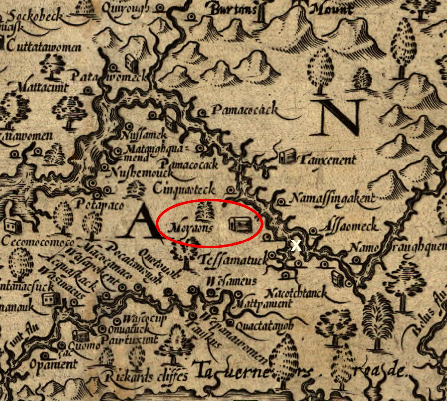
John Smith recorded the "king's house" of the Piscataway when explored the area in 1608 (white X is now Washington DC)
Source: Library of Congress, Virginia (by John Smith, 1624)
The Piscataway may have evolved from a group that migrated down the Potomac River between 1300-1400 CE (Common Era). According to the Montgomery Hypothesis, a group living along the Potomac River between the Blue Ridge and the Fall Line was displaced by others who moved into the region from the north.
The displaced group - the Montgomery complex people - moved downriver from the Piedmont to the other side of the Fall Line. At the same time, people sharing the Mason Island culture were displaced from the Potomac River valley upstream of the Blue Ridge and forced to move into the Virginia Piedmont south of the river.
The migrants forced to move below Great Falls established new towns at Accokeek and Potomac creeks in Virginia, and later in the Mason Neck region. On the opposite side of the river, which was a water highway rather than a transportation barrier for the skilled canoeists, they built the town of Moyaone at the mouth of Piscataway Creek.
The settlers at Moyaone became known as the Piscataway, an Algonquian-speaking confederation of different tribes (including Choptico, Mattawoman, Nanjemoy, Potapaco, Yaocomaco, and Zekiah) with close ties to the Patawomeck. They traded with the Iroquian-speaking Susquehannocks to the north, and built longhouses similar to the Iroquois rather than the circular yi-hakins structures of the Powhatans.
The Piscataway had moved downstream of Moyaone and already abandoned the site of Moyaone before English colonists arrived. Archeologists later excavated 1,000 burials at Moyaone.
The Piscataway actively traded with the closely-allied Anacostin (also called Nacotchtank) and other tribes on the Eastern Shore. The 300 Nacotchtank occupied several villages along the Potomac and the Anacostia rivers, including one at the future site of Bolling Air Force Base.
Their location on the Potomac River enabled them to engage in trade with the Iroquois and southern tribes; "Anaquashatanik” in Algonquian means "a town of traders." The Nacotchtank were the middlemen for the Iroquoian-speaking Massawomecks, who brought furs from west of the Potomac River watershed.
Not all trade deals went smoothly. When about 20 Virginia colonists arrived in 1623 to acquire corn, the deal went sour. All but one of the colonists was killed. The one survivor, Henry Fleet, ended up as a captive for five years. He then became a translator and trader.
The allied Dogue/Moyumpse lived at the mouth of the Occoquan River, across the Potomac River from the mouth of Piscataway Creek.
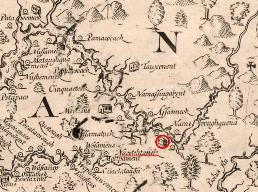
John Smith documented the chief town of the Nacotchtank, near the mouth of the Anacostia River and upstream of the Piscataway
Source: Library of Congress, Virginia (by John Smith, 1624)
According to one story told by the brother of the tayac in 1660, the first tayac came from the Eastern Shore thirteen generations before the first English immigrants into Maryland.2
Colonists sailed to the new colony of Maryland on the Ark and Dove, and arrived at St. Clemet's Island on March 25, 1634. They dealt initially with Wannas, the head chief. The first Maryland settlement of St. Mary's City was in territory of the Yaocomaco, who paid tribute to Wannnas and treated the Piscataway tayac as their "emperor."
Governor Calvert negotiated successfully for the right to occupy the land. The English were welcomed because the Piscataway were losing territory and population in their competition with the Susquehannock, who may have been the descendants of the northern group that originally forced migrations out of the Potomac River valley in 1300-1400 CE (Common Era). The Yaocomoco were already preparing to move to live with the Piscataway, consolidating to provide better defense against raids by the Susquehannock.
The Jesuit priests who came in 1634 immediately sought to convert the Native Americans to the Catholic faith. "Indian King" Kittamaquund was baptized in 1640.3
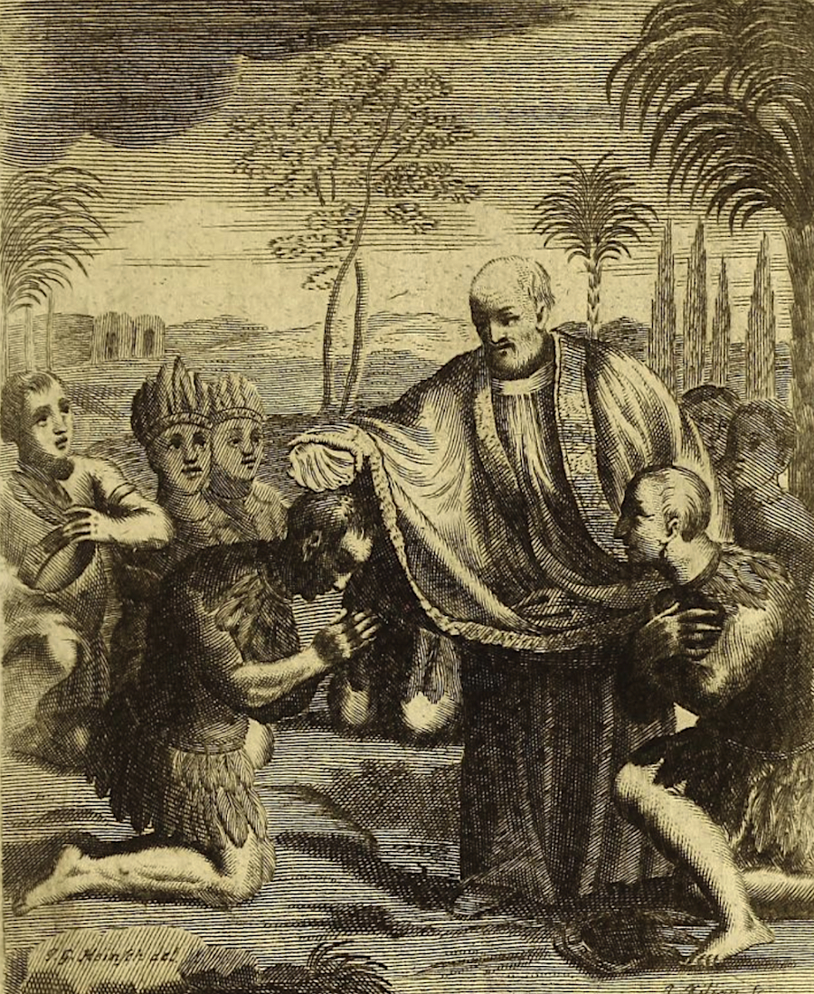
after Maryland colonists landed in 1634, Father White sought to convert the Piscataway to the Catholic faith
Source: Internet Archive, Societas Jesu apostolorum imitatrix, sive Gesta praeclara et virtutes eorum (1694, p.803)
More than preaching was used to gain control over the Piscataway territory. On the Eastern Shore, Maryland colonists went to war against the Maquantequats in 1639. Governor Leaonard Calvert issued the authorization in a letter sent to Nicholas Hervey:4
- Whereas certain Indians of the Nation called the Maquantequats have Comitted Sundry Insolencies and rapines upon the English Inhabiting within this Province and being thereof demanded Satisfaction heretofore have refused to make any, and therefore Compelled us to enforce them thereunto by the Justice of a warr
- These are therefore to authorise you with any, Company of English as Shall be willing to goe along with you Soe they exceed the number of twelve men Sufficiently provided of arms to invade the Said Mancantequuts only and against them and their Lands and goods to execute and Indict what may be inflicted by the Law of warr and the pillage and booty therein gotton to part and divide among the Company, that Shall performe the Service And for Soe doeing this Shall be your or Comission Given at St Maries this 3d January 1639.
Maryland colonists gained control over the selection of the Piscataway tayac (leader) by 1641. In 1666, after Iroquois raids had reduced the population and weakened the tribe's ability to defend itself, the tayac signed "Articles of Peace and Amity" which affirmed their subordinate status to the Maryland colonists.
Under the treaty, a reservation for the Piscataway was established at Piscataway Manor. The treaty guaranteed hunting and fishing rights, saying:5
- The Priviledge of Hunting, Crabbing, fishing, And fowling shal be preserved to the Indians Inviolably
Two years later, the Maryland colony signed a similar treaty with the Nanticoke tayac Unnacokasimmon. Despite four more treaties and designation of reservations for the Nanticoke, colonists continued to encroach on Nanticoke territory and constrained their ability to travel for winter hunts. In 1744, most members of the Nanticoke moved north to join the Iroquois or east into Delaware.6
During the prelude to Bacon's Rebellion and the fighting in 1675-1676, the Piscataway survived the attempts of the Susquehannocks and Five Nations to displace them and/or make them subordinate. The Iroquois were successful in establishing dominance over the Susquehannocks. By 1674, the Iroquois forced them to abandon their traditional homeland in the watershed of the Susquehanna River.
Governor Calvert of Maryland invited the tribe to move to the Potomac River. The Susquehannocks declined his proposal to relocate to Little Falls/Great Falls, and instead built a fort near the mouth of Piscataway Creek. They picked Mockley Point, north of other Native American settlements.
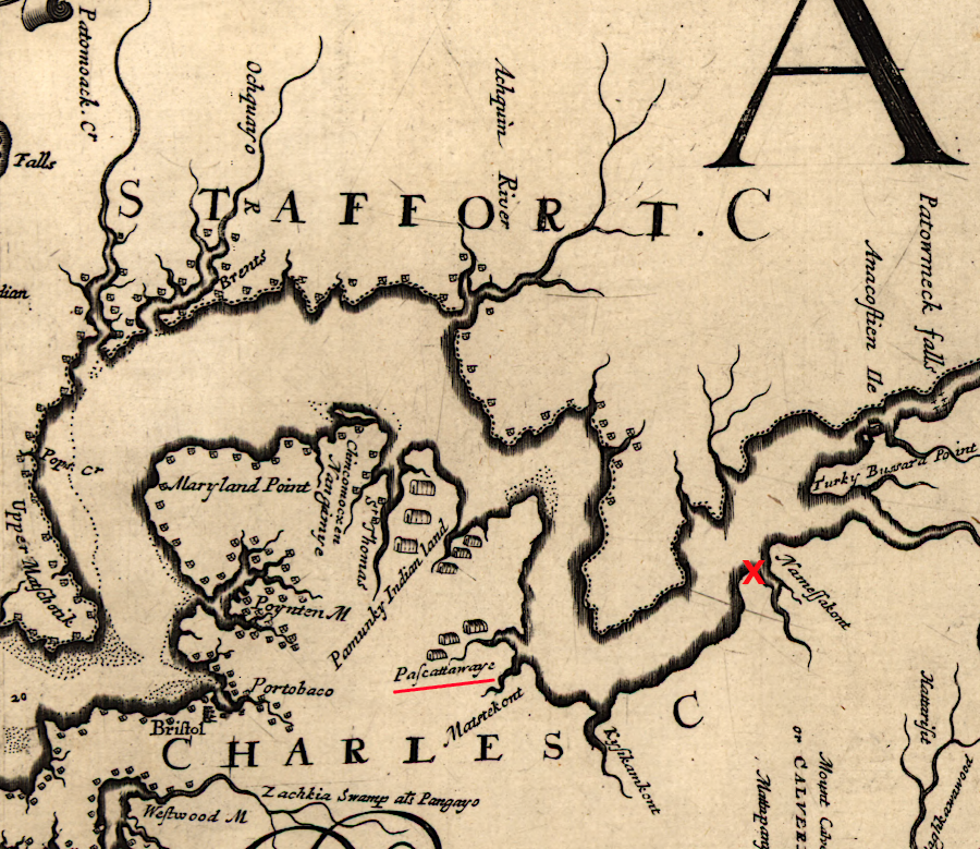
the Susquehannocks did not displace the Piscataway when they relocated to Mockley Point (red X) in 1675
Source: Library of Congress, Virginia and Maryland as it is planted and inhabited this present year 1670 (by Augustine Herrman)
Virginia colonists living in Stafford County, angered by what they considered theft and murder by the Dogues, sent raiding parties across the Potomac River to retaliate. By mistake the Virginians attacked the peaceful Susquehannocks, with whom they had been trading.
The attacks and Susquehannock response escalated, and in 1675 the Susquehannocks went to war against the Virginians. That morphed into a colonial civil war in Virginia known as Bacon's Rebellion, during which the Piscataway allied with Maryland's forces against the Susquehannocks.
Governor Calvert relocated the Piscataway in 1680 from their old base on Piscataway Creek to Zekiah Swamp, which the governor controlled personally as a proprietary manor in Charles County. The swamp, a rich source of food, was more isolated from the Virginians and Iroquois.7
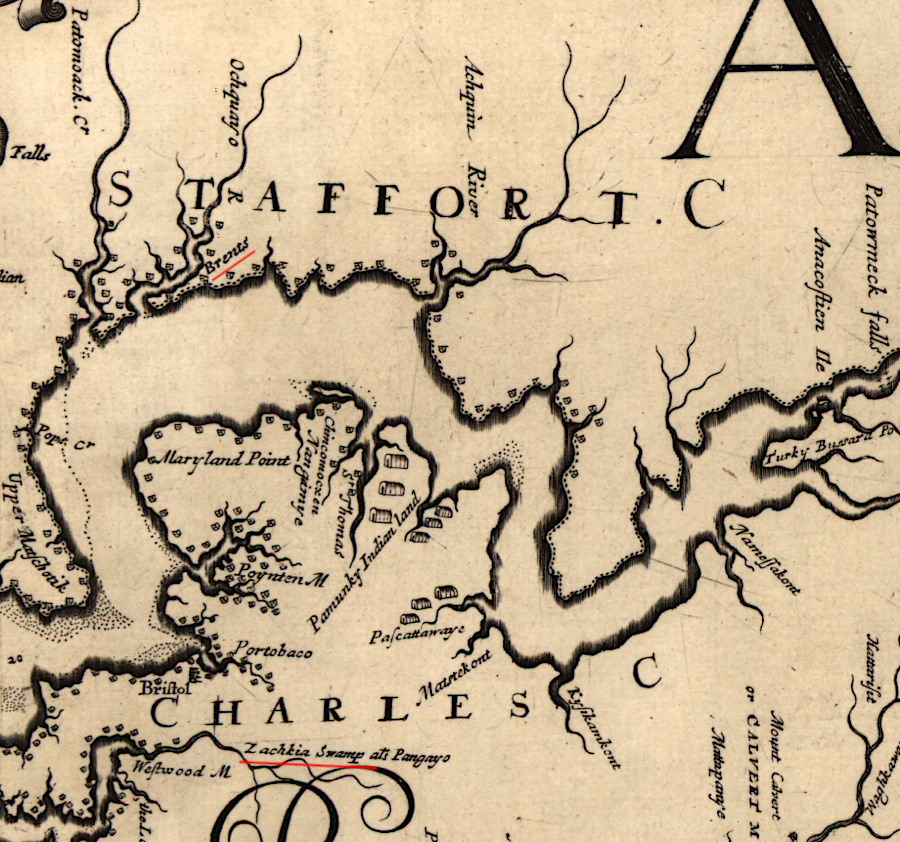
the Piscataway were relocated to Zekiah Swamp in 1680
Source: Library of Congress, Virginia and Maryland as it is planted and inhabited this present year 1670 (by Augustine Herrman)
Dealing with the colonists was a constant challenge. Many of the Piscataway chose to leave Maryland, moving initially into Virginia in 1697. A group settled on an island in the Potomac River where there was a shallow ford.
They built a fort and about 30 houses on what was called Conoy Island; Conoy is another name used for the Piscataway. It was later called Heater's Island. Today it is part of Maryland's Islands of the Potomac Wildlife Management Area, next to Piscataway Crossing Regional Park in Loudoun County.8
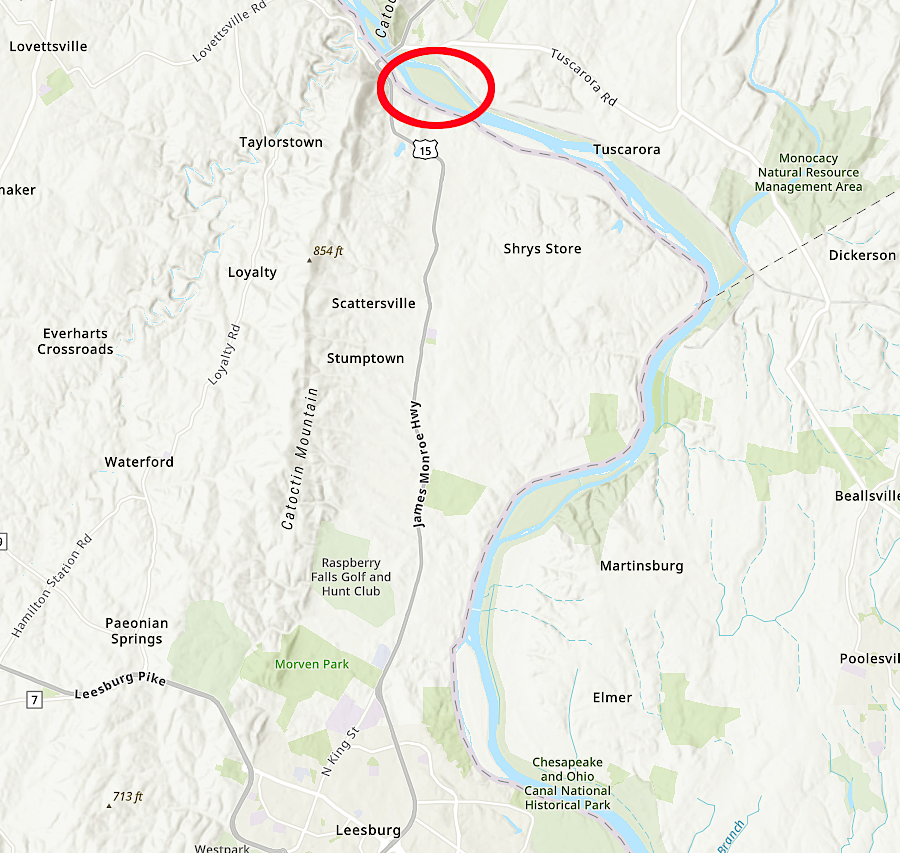
the Piscataway/Conoy lived briefly on an island in the Potomac River in the early 1700's, before moving further north
Source: ESRI, ArcGIS Online
After about a dozen years, those Piscataway/Conoy migrated north into the lands along the Susquehanna River. That territory became available after the Iroquois had displaced the Susquehannocks in the 1670's, then allowed them to return as a dependent tribe.
Other tribal groups disrupted by the Iroquois, including Delaware and some Susquehannock, chose to move to the Susquehanna River as well in the early 1700's. They were joined by Seneca coming south, a group which became knows as Mingo and morphed into a tribe known as the Conestoga. In 1763, at the time of Pontiac's Rebellion in the Ohio River Valley, a mob known as the Paxton Boys destroyed the town and killed nearly all the peaceful Native American inhabitants.9
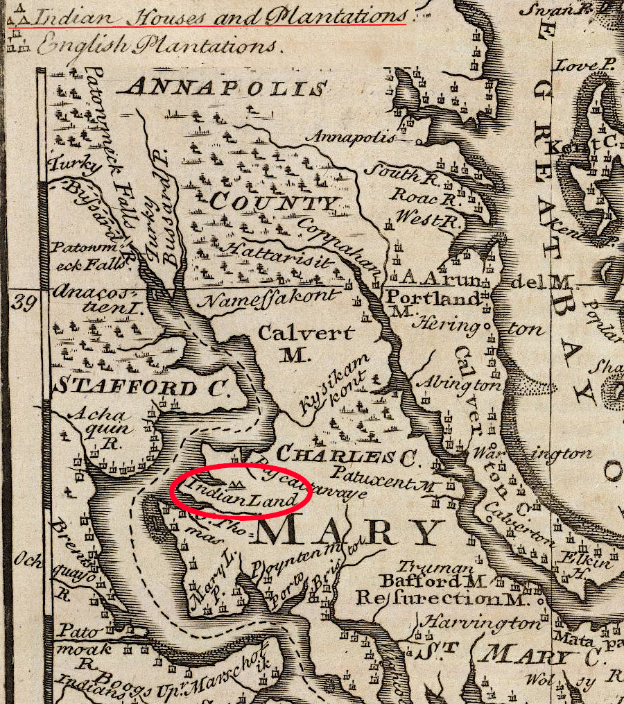
despite colonial interference, some Piscataway managed to remain in Maryland while others migrated to Pennsylvania and New York
Source: David Rumsey Map Collection, A New and Accurate Map of Virginia & Maryland (by Emanuel Bowen, 1747)
The governor of Maryland issued an executive order which officially recognized the Piscataway Conoy Tribe and the Piscataway Indian Nation in 2012.10
In 2019, the Piscataway Indian Nation and the Piscataway Conoy Tribe requested that the District of Columbia issue free fishing licenses to all members. Fish from the Anacostia and Potomac rivers within the District boundaries were not viewed as safe to eat, but the request was intended primarily to highlight Native American identify in the region. The DC City Council approved legislation granting the request in 2020.
One member of the tribe fished regularly at Quantico. Depending upon where her line was in the water, she might be fishing in a cove within the boundaries of Virginia rather than in the Potomac River located within Maryland. She purchased a license to eliminate any question regarding the right to fish, but was fond of alerting conservation officers that under the terms of the 1666 treaty, she did not need one.11
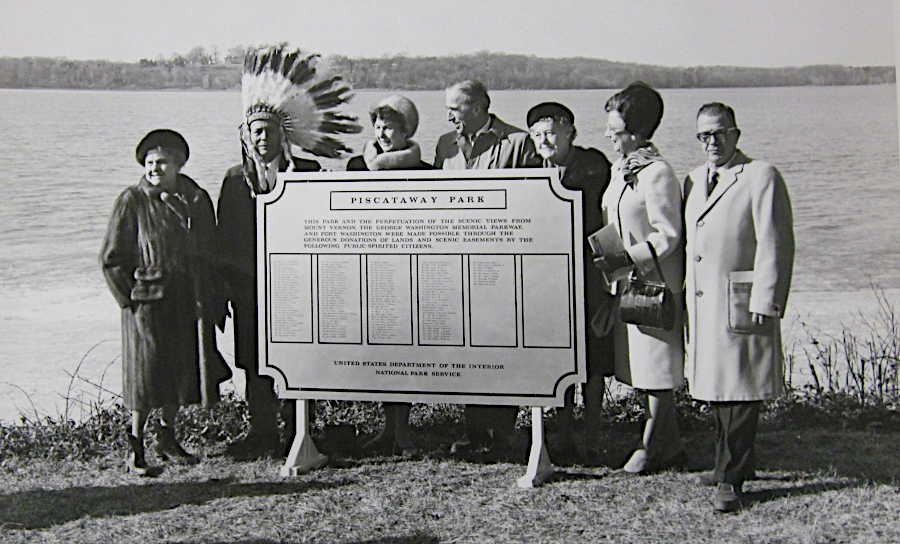
Chief Turkey Tayac was easily recognizable when Piscataway Park was dedicated in 1968
Source: Piscataway Park, National Park Service, Group photo by Piscataway sign
Links
References
1. Alex J. Flick, Skylar A. Bauer, Scott M. Strickland, D. Brad Hatch, Julia A. King. "...a place now known unto them:" The Search for Zekiah Fort, St. Mary's College of Maryland, 2012, pp.11-14, https://www.academia.edu/2484589/_A_Place_Now_Known_Unto_Them_The_Search_for_Zekiah_Fort_by_Alex_J._Flick_Skylar_A._Bauer_Scott_M._Strickland_D._Brad_Hatch_and_Julia_A._King; "Unearthing Native American history on an island in Southern Maryland," Washington Post, November 7, 2022, https://www.washingtonpost.com/history/2022/11/07/native-americans-st-clements-island/
2. Stephen Potter, Commoners, Tribute, and Chiefs: The Development of Algonquian Culture in the Potomac Valley, University of Virginia Press, 1994, p.132, pp.137-138, https://www.google.com/books/edition/Commoners_Tribute_and_Chiefs/IWQfeDJYlewC; "A Native American tribe once called D.C. home. It's had no living members for centuries," Washington Post, November 22, 2018, https://www.washingtonpost.com/history/2018/11/22/native-american-tribe-once-called-dc-home-its-had-no-living-members-centuries/; "Accokeek Creek Site," Maryland Historical Trust, https://apps.mht.maryland.gov/nr/NRDetail.aspx?NRID=11; "We're Still Here," Baltimore Magazine, November 2025, https://www.baltimoremagazine.com/section/historypolitics/indigenous-piscataway-tribe-maryland-history/; "Piscataway Indian Museum, White Plains, Md.," Southern Maryland Online, https://somd.com/catalog/1471.php; Dr. Matthew D. McKnight, "The Remarkable Survival and Resilience of Maryland’s Piscataway Peoples," The Maryland Historical Trust blog, November 24, 2023, https://mdhistoricaltrust.wordpress.com/2023/11/24/the-remarkable-survival-and-resilience-of-marylands-piscataway-peoples/ (last checked August 19, 2026)
3. Skylar A. Bauer, Julia A. King, Scott M. Strickland, "Archaeological Investigations at Notley Hall Near Chaptico, Maryland," St. Mary's College of Maryland, 2013, p.6, https://www.academia.edu/10311813/Archaeological_Investigations_at_Notley_Hall_Near_Chaptico_Maryland; "Piscataway Indians," Catholic Answers, https://www.catholic.com/encyclopedia/piscataway-indians; "We're Still Here," Baltimore Magazine, November 2025, https://www.baltimoremagazine.com/section/historypolitics/indigenous-piscataway-tribe-maryland-history/ (last checked August 18, 2026)
4. "Proceedings of the Council of Maryland, 1636-1667," Archives of Maryland Online, Volume 3, Page 87, https://msa.maryland.gov/megafile/msa/speccol/sc2900/sc2908/000001/000003/html/am3--87.html (last checked August 18, 2026)
5. Anna Coxe Toogood, "General Historic Background Study, Piscataway Park, Maryland," National Park Service, September 1969, p.46, p.146, http://npshistory.com/publications/pisc/gen-hist-background.pdf (last checked September 8, 2020)
6. "History," the Nanticoke Indian Tribe, https://www.nanticokeindians.org/page/history; "Our Tribal History," The Nanticoke Lenni-Lenape, https://nanticoke-lenape.info/history.htm; "Lost Tribes Of The Eastern Shore," Washington Post, September 1, 1991, https://www.washingtonpost.com/archive/opinions/1991/09/01/lost-tribes-of-the-eastern-shore/fcbe2ead-f7bd-45b8-a105-3d65ae4115ad/ (last checked February 7, 2021)
7. Alex J. Flick, Skylar A. Bauer, Scott M. Strickland, D. Brad Hatch, Julia A. King. "...a place now known unto them:" The Search for Zekiah Fort, St. Mary's College of Maryland, 2012, p.1, https://www.academia.edu/2484589/_A_Place_Now_Known_Unto_Them_The_Search_for_Zekiah_Fort_by_Alex_J._Flick_Skylar_A._Bauer_Scott_M._Strickland_D._Brad_Hatch_and_Julia_A._King (last checked February 7, 2021)
8. Dennis C. Curry, "Heater's Island and the Piscataway Indians," Our History, Our Heritage, The Maryland Historical Trust Blog, April 24, 2015, https://mdhistoricaltrust.wordpress.com/2015/04/24/heaters-island-piscataway/; Eugene Scheel, "1699 Encounter With Piscataway Indians Was a First," The History of Loudoun County, Virginia, https://www.loudounhistory.org/history/indians-piscataway/; "Park History Interpretive Series: The Piscataway People of the Potomac," NOVA Parks, https://www.novaparks.com/parks/piscataway-crossing-regional-park/things-to-do/park-history-interpretive-series-the (last checked August 19, 2026)
9. "We're Still Here," Baltimore Magazine, November 2025, https://www.baltimoremagazine.com/section/historypolitics/indigenous-piscataway-tribe-maryland-history/; "Indian history in Pa.: Penny for thoughts, millions for gambling," Pocono Record, January 10, 2004, https://www.poconorecord.com/story/news/2004/01/11/indian-history-in-pa-penny/51066303007/ (last checked August 19, 2026)
10. "History," The Official Piscataway Conoy Tribe, https://www.piscatawayconoytribe.com/index.php/history; "Maryland's Piscataway Tribes Receive State Recognition," WAMU, January 10, 2012, https://wamu.org/story/12/01/10/marylands_piscataway_tribes_receive_state_recognition/ (last checked August 18, 2026)
11. "D.C. bill would honor 17th-century treaty by granting Native Americans free fishing licenses," Washington Post, November 27, 2019, https://www.washingtonpost.com/local/dc-politics/dc-bill-would-honor-17th-century-treaty-by-letting-native-americans-fish-for-free/2019/11/27/94eedbe0-0fab-11ea-b0fc-62cc38411ebb_story.html; "D.C. Council votes to rename Lafayette rec center and park, honor long-ignored Indian treaty," Washington Post, December 1, 2020, https://www.washingtonpost.com/local/dc-politics/dc-renaming-lafayette-pointer/2020/12/01/5ac2442a-334f-11eb-a997-1f4c53d2a747_story.html (last checked December 2, 2020)
"Indians" of Virginia - the Real First Families of Virginia
Exploring Land, Settling Frontiers
Virginia Places