Limestone in Virginia
the limestone deposits in Loudoun County were mined primarily for agricultural lime prior to the Civil War
Source: Library of Congress, A map of the state of Virginia, constructed in conformity to law from the late surveys authorized by the legislature and other original and authentic documents (1859)
Virginia has different types of rocks rich in calcium carbonate, including limestone, dolomite, marl, marble and travertine.
Virginia's tourist caves have been etched out naturally within limestone that was deposited 570-350 million years ago. The caves themselves are much younger that the bedrock.
Various types of cave formations, primarily stalactites and stalagmites, evolved as calcium carbonate dissolved in groundwater has crystalized. The youngest limestone in Virginia solidified in the last second, when a drip of water evaporated at the end of a "soda straw" formation in a Virginia cave and deposited a tiny addition to that straw.
The first major limestone and dolomite deposits formed as carbon dioxide in the atmosphere was absorbed into the oceans. Dissolved gases combined with dissolved ions of calcium, and supersaturated calcium carbonate (CaCO3) crystals were precipitated as limestone onto the bottom of the ocean floor. Dolomite, a calcium-magnesium carbonate with a chemical formula of CaMg(CO3)2, formed as magnesium and calcium atoms aligned with carbonate molecules (CO3) in orderly rows on the edge of growing crystal surfaces.
Dolomite formed when tides or currents swept across the crystals regularly. The water dissolved calcium and magnesium atoms which had not aligned consistently, allowing dolomite crystals to grow in consistent layers.1
The earth's atmosphere and oceans have maintained an equilibrium that sequestered carbon in limestone and dolomite.
In contrast, once-similar Mars had an atmosphere with a higher percentage of sulfur. When dissolved in the oceans that once existed on Mars, the resulting sulfuric acid prevented the precipitation of limestone and dolomite. Rovers sent to Mars are finding sulfur-rich minerals in the places where water once existed. In contrast, Earth's oceans are coated in calcium-rich minerals.2
Within what is now Virginia, the oldest limestone accumulated as much as 750 million years ago at a time when Virginia was part of the supercontinent Rodinia. During or after a failed rifting event, volcanic eruptions and eroding sediments created the formations around Mount Rogers. Heat from the vulcanism metamorphosed limestone-rich sediments into marble. Local tradition holds that a block of stone from a quarry in Grayson County near Troutdale was used in the construction of Grant's Tomb.3

active and abandoned limestone quarries are located at Front Royal on the Shenandoah River
Source: ESRI, ArcGIS Online
Around 600 million years ago, carbonates accumulated in shallow freshwater lakes and/or in marine bays in what is now Loudoun County. Those sediments were gradually buried below the sands and cobbles deposited by freshwater rivers, or in saltwater embayments.4
When Rodinia split up, massive basaltic lava flows erupted and the sandy and lime-rich sediments were buried. Later tectonic forces in the Taconic, Neo-Acadian, and Alleghenian orogenies also generated heat and pressure. The sediments were compressed into rocks ("lithified") known today as the Swift Run Formation, and the beds of limestone metamorphosed into marble.
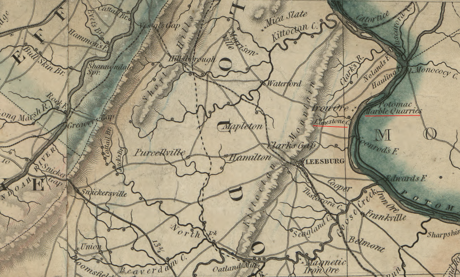
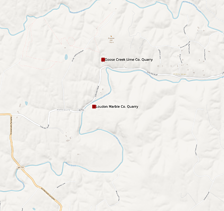
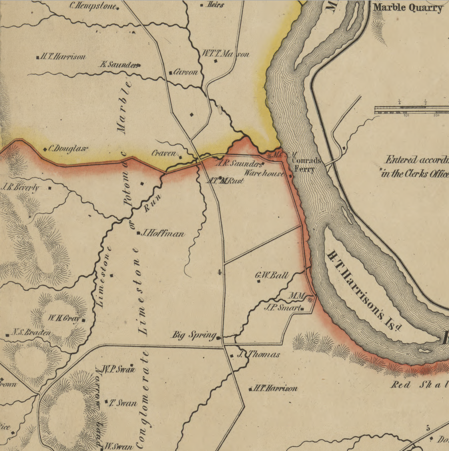
By the time Thomas Jefferson was elected president, the 50' thick layer of breccia known as "Potomac Marble" was being quarried near Goose Creek in Loudoun County. The rock was actually a sedimentary layer deposited in the Triassic Period. "Marbles" or pebbles of broken rock were encased in a matrix of limestone. The rock was crushed, burned to produce agricultural lime, and spread on the fields of Oatlands and other plantations to enhance productivity of the soil. The Virginia Marble Company operated the quarries after the Civil War, and it became one of the largest employers of African-American men in the county.

tectonic pressures metamorphosed Precambrian deposits of limestone into marble (circled in blue) which was mined near Goose Creek between 1798-1949
Source: US Geological Survey (USGS), Geologic Map of Loudoun County, Virginia
That Loudoun County marble was used to produce the Confederate memorial erected in Little Washington, Rappahannock County and the 1898 Confederate Heroes Monument in Page County. (A second marble monument installed later in downtown Luray, and two other Confederate soldier memorials in Lunenburg and Spotsylvania counties, were sculpted in Georgia.) The Virginia Marble Company produced terrazzo (marble chips) until 1949 at Goose Creek.5
The largest Virginia deposits of limestone and dolomite are in the Valley and Ridge physiographic province. Limestone outcrops are readily visible along Interstate 81, which crosses that province from the Shenandoah Valley in the north to the Tennessee border.

nearly all limestone exposed at the surface in Virginia today was deposited in the Iapetus Ocean, before the addition of the land between the Blue Ridge and Atlantic Ocean
Source: ESRI, Ecological Tapestry of the World
Roughly 500 million years ago, the region was located at the edge of the supercontinent Rodinia. It was underwater, near the shoreline of a part of the Iapetus Ocean known as the Sauk Sea. At the time, "Virginia" was located south of the Equator, and coral reefs grew in the warm waters. Zooplankton and larger forms of life protected by shells thrived in the Sauk Sea. When they died and sank to the bottom, deposits of limestone (and magnesium-rich dolomite) gradually accumulated.
Tectonic forces moved chunks of continental crust and closed the Iapetus Ocean. Terranes from island arcs were pushed against the edge of Virginia in the Taconic, Acadian, and Alleghenian orogenies. The island arcs widened the crust over the last 400 million years to create the Piedmont and Coastal Plain physiographic provinces, but the orogenies also narrowed the old continent. The sediments on the floor of the Sauk Sea were cracked, thrust slid up ramps of softer shales, and stacked on top of other layers like pancakes.

tectonic forces during orogenies cracked sedimentary layers at weak zones and slid layers of limestone on top on one another, like a stack of pancakes
Source: US Geological Survey (USGS), Lateral Ramps in the Folded Appalachians and in Overthrust Belts Worldwide - A Fundamental Element of Thrust-Belt Architecture (Figure 4A)
A slice of the igneous bedrock, the granites and gneisses deep underneath the Sauk Sea sediments, was a slice broken off the edge of the continent. That crust was shoved 40 miles to the west, emplacing the Blue Ridge at least partially on top of the much younger limestone/dolomite layers. The Blue Ridge fault marks the western edge of the slice of igneous bedrock that was moved westward.
Carbonate layers that were once at the bottom of the Sauk Sea, on the edge of Rodinia, are now west of the Blue Ridge and far from the modern shoreline. Those limestone/dolomite sediments are the common bedrock in the Shenandoah Valley, in the Roanoke Valley, in the New River Valley, and in the valleys of the Tennessee River's upper tributaries (Holston, Clinch, and Powell rivers).
Today, limestone is being deposited again on the edge of the continent. The Iapetus Ocean, once on the edge of Virginia, was eliminated by the formation of the supercontinent Pangea. Like Rodinia, Pangea has cracked up and today the Atlantic Ocean is on the edge of Virginia. Calcium-rich shells of dead zooplankton are slowly accumulating on the bottom of the Atlantic Ocean, creating new limestone formations in a process comparable to how the bedrock of the Shenandoah Valley formed 300-500 million years ago.

for over the last 150 million years, new limestone formations have been deposited at the bottom of the Atlantic Ocean on the passive continental margin
Source: National Park Service, Mature Ocean Basin Diagram
Some of the large limestone quarries crush what they excavate to produce agricultural lime, but most quarries sell the stone for construction. In addition to serving as gravel, foundation stones, and facing stone on the exterior of buildings, some quarried limestone is used to create wallboard and cement. Cement is 10-15% of concrete, "the most abundant manufactured material on the planet," but cement is the essential ingredient that glues together the sand and aggregate particles.
Virginia's only remaining cement manufacturer is Roanoke Cement Company, with a quarry and adjacent processing plant located near Tinker's Cliffs in Bedford County. The company excavates its raw material from the Moccasin Formation, which was deposited in the Ordovician Period over 450 million years ago before land plants had spread across the continents.6


Roanoke Cement Company, Virginia's only active cement plant, converts rock over 450 million years old into cement
Source: PW Newswire, Roanoke Cement Company Honored by EPA's Energy Star Program for 11th Straight Year (July 27, 2017) and Virginia Department of Energy, Geology Mineral Resources
As far back as the mid-1700's, Shenandoah Valley residents used limestone blocks to build fortified houses that offered protection against Shawnee, Seneca, and Cherokee raids. The standard architecture at Virginia Tech relies upon quarries near Blacksburg that supply "Hokie Stone" from sediments deposited 500 million years ago. Courthouses and other public buildings west of the Blue Ridge are often made of limestone.
Railroads haul crushed limestone from the Shenandoah Valley east through the Blue Ridge and use the gravel as ballast to support the track beds. East of Thoroughfare Gap, where the exposed bedrock is red sandstone or black basalt, railroad tracks are placed on top of distinctly-colored grey limestone gravel. The ballast appears out of place in the iron-rich bedrock of the Culpeper Basin.
One major deposit of limestone is exposed on the surface near Leesburg, east of the Blue Ridge in Loudoun County. Limestone conglomerate at Raspberry Falls/Leesburg ("Calico marble" or "Potomac marble") is the Leesburg Member of the Balls Bluff Siltstone. The limestone cobbles in the conglomerate were deposited originally in the Sauk Sea, in sediments now exposed in Frederick County Maryland as the Frederick Limestone and Tomstown Formation. During the Triassic Period, carbonate clasts were eroded in storms, carried downstream in flooded river channels, and deposited in debris-flow deposits on alluvial fans in the Culpeper Basin.7
The "Potomac marble" is actually a conglomerate, not metamorphosed limestone. When the Capitol in Washington, DC was rebuilt after being burned by British troops in 1814, the "marble" was quarried in Maryland and used by Benjamin Latrobe for the columns in the Senate Chamber. Those columns are sill visible in what is now Statuary Hall.
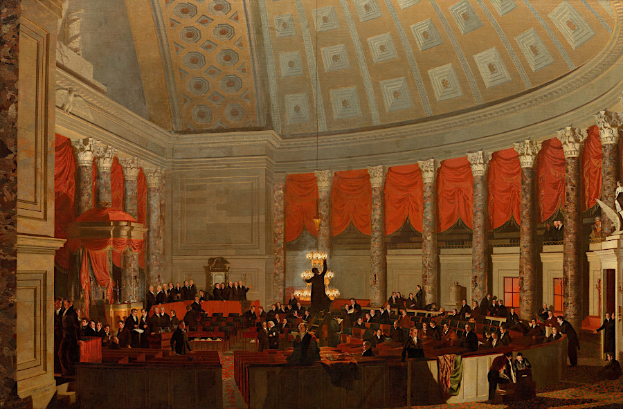
when the US Capitol was rebuilt after 1814, Potomac Marble was used for the columns in the Senate Chamber
Source: National Gallery of Art, The House of Representatives (by Sanmuel F. B. Morse, 1822)
Conglomerate mined near Leesburg was processed into agricultural lime. One historic quarry is located near the modern pond in Olde Isaak Walton Park. Others are located on Lime Kiln Road, between US 15 and Snickersville Turnpike.
Lime Kiln Road in Loudoun County reveals the geologically-based industry there
Source: US Geological Survey (USGS), Mineral Resources Data System
The only known natural caves in Virginia located east of the Blue Ridge are in the Leesburg Member, north of Leesburg. There are also sinkholes in Loudoun County east of Route 15, and the local geology is reflected in the name of the stream "Limestone Branch."
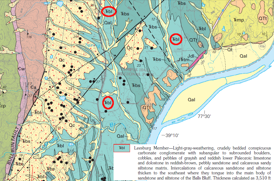
the only natural caves in Virginia east of the Blue Ridge are in the conglomerate known as the Leesburg Member (circled in red), which also produced sinkholes at Temple Hall Regional Park
Source: US Geological Survey (USGS), Geologic Map of Loudoun County, Virginia
Limestone Run in Loudoun County is now called Limestone Branch
Source: Library of Congress, Map of Loudoun County, Virginia (by Yardley Taylor, 1854)
There is also a Limestone Creek that flows into the Rivanna River in Albemarle County, five miles southeast of Monticello. Thomas Jefferson purchased in 1771 and 1773 four acres of "limestone land" (Everona Formation) for production of mortar, which was needed to build his mansion house. The lime-based mortar was used between the bricks to cement them into weight-bearing walls, and to coat the columns on the West Front that appear on the nickel coin.
Lime produced from the Everona Member of the True Blue Formation was also used to build the University of Virginia. The layer of limestone is 1,000' thick at Limestone Creek, in the trough of the Everona Syncline.9

Jefferson bought a quarry on Limestone Creek, to obtain lime from the Everona Member for building Monticello
Source: US Geological Survey (USGS), The National Map
Orange County has identified the Everona Limestone as "one of the County’s greatest groundwater assets," and mapped it as part of the Groundwater Protection Zone.10

the Orange County Comprehensive Plan identifies the Everona Limestone, in the trough between two slices of the Blue Ridge, as a potential source of groundwater
Source: Orange County, 2013 Comprehensive Plan (p.81)
Limestone in Virginia is crushed for both agricultural use as a fertilizer, and for a variety of industrial uses. Underground coal mines spray a slurry with limestone on their walls, to reduce methane emissions which could become explosive. The decline in underground coal mining, as natural gas became less expensive after fracking increased supply, led to a layoff at the Carmeuse Lime and Stone quarry outside of Strasburg. The quarry was located far from the coal mines, but had developed a successful business selling "rock dust" to increase safety underground. As coal-fired power plants closed, demand for the limestone powder declined along with the demand for coal.11
In 2019 the Clorox Company, which sold Fresh Step cat litter, wanted to build a manufacturing facility next to the Carmeuse quarry in Strasburg. Frederick County was an attractive site for the business because of local labor availability and wages, and the particular site was preferred because limestone is a key ingredient in cat litter. A conveyor belt was planned to transport the raw limestone excavated from the quarry to the plant, and the final product would be transported via the adjacent Norfolk Southern railroad.
Frederick County supervisors rejected a rezoning proposal on 146 acres that was needed for construction of the cat litter plant, despite the potential addition of 100 jobs and $500,000 annually in tax revenue. Residents on Brucetown Road objected to the anticipated truck traffic on a road with already was rated with a Level of Service of "F" by the Virginia Department of Transportation. The Clear Brook quarry had at least a 15-year supply of limestone, but supervisors were concerned that eventually the limestone might be trucked via Brucetown Road to the cat litter plant.12
In 2023, the Frederick County Board of Supervisors did approve in a 5-2 vote a rezoning for Carmeuse Lime and Stone to open a new limestone quarry. It was planned on 392 acres, slightly over a mile away from the existing quarry. People living near the site objected to anticipated blasting, lowering of the water table, and increased truck traffic. Impacts would begin in 8-15 years, as supply of accessible stone at the existing quarry was exhausted.
One neighbor objecting to the rezoning testified:13
- ...studies show property values decrease 25 to 30% on land up to several miles away from active quarries. If the rezoning is allowed, think about how that will affect landowners whose property is adjoined to the land zoned for extractive mining. They thought they bought land in a nice rural setting.
Underground mining extracts limestone in Giles County. Virginia Tech uses the mine for its Kimballton Underground Research Facility. The physics department has facilities on the surface, plus two underground at different levels at which cosmic rays are attenuated due to the density of limestone. The limestone has little radioactive material, so it emits few gamma photons and neutrons that might interfere with the sensitive measurements of neutrinos, muons, and other subatomic particles that penetrate deep underground.14
In 2022, a cave-in engulfed and killed an equipment operator mining the limestone.
The limestone was burned in kilns at the surface before being shipped via the Norfolk Southern railroad to steelmaking plants. Excessive sulfur dioxide emissions caused the Virginia Air Quality Control Board to place Kimballton Plant No. 1 on the air pollution non-attainment list. When listed in 2022, the kilns became the only industrial facility in the state on that list.15

the Kimballton mine in Giles County is underground, with kilns which burn the limestone visible on the surface
Source: ESRI, ArcGIS Online
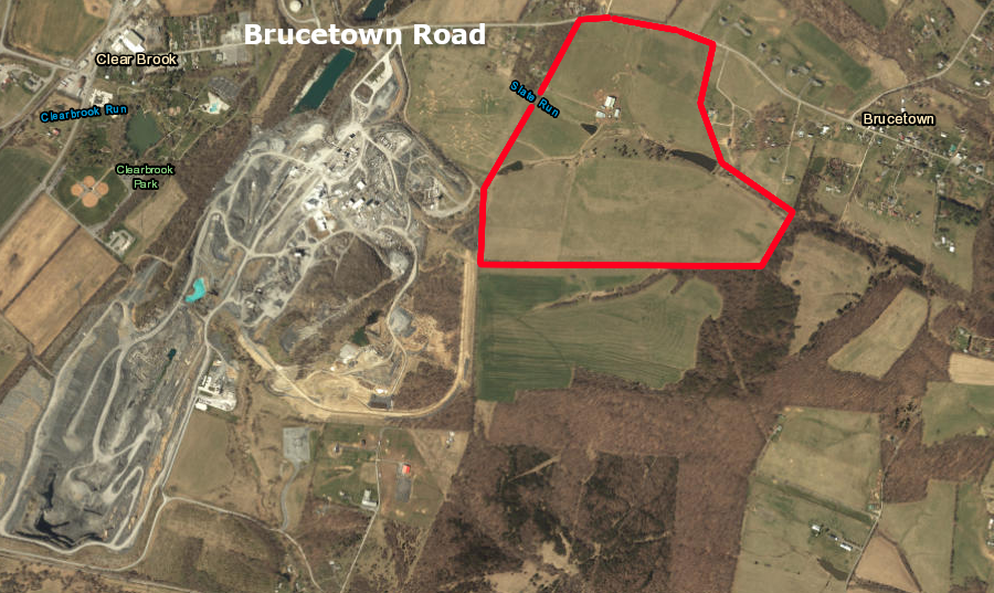
the Clorox cat litter plant would have been located on 146 acres (red polygon) near the Carmeuse quarry in Frederick County
Source: ESRI, ArcGIS Online
Links

in the Cambrian Period, the limestones of the Valley and Ridge physiographic province were deposited in a shallow Iapetus Ocean
Source: Dr. Ron Blakey, Paleogeography and Geologic History of North America
References
1. "The “Dolomite Problem” - Scientists Resolve 200-Year-Old Geology Mystery," SciTechDaily, January 8, 2024, https://scitechdaily.com/the-dolomite-problem-scientists-resolve-200-year-old-geology-mystery/; Joonsoo Kim, Yuki Kimura, Brian Puchala, Tomoya Yamazaki, Udo Becker, Wenhao Sun, "Dissolution enables dolomite crystal growth near ambient conditions," Science, Vol 382, Issue 6673 (November 23, 2023), https://doi.org/10.1126/science.adi3690; Dr. Dan Doctor, "Determining the Age of a Cave," Virginia Cave Owners Newsletter, April 2012, https://www.dcr.virginia.gov/natural-heritage/document/vacaveownersnewsletter24apr12.pdf (last checked January 15, 2023)
2. "This Is Why Mars Is Red And Dead While Earth Is Blue And Alive," Forbes, May 14, 2019, https://www.forbes.com/sites/startswithabang/2019/05/14/this-is-why-mars-is-red-and-dead-while-earth-is-blue-and-alive/#680c0536395b (last checked January 8, 2023)
3. Harry W. Webb, Palmer C. Sweet, "Interesting Uses Of Stone In Virginia - Part I,", Virginia Minerals, Virginia Department of Mines, Minerals and Energy, Volume 38 Number 4 (November 1992), p.31, https://www.dmme.virginia.gov/commercedocs/VAMIN_VOL38_NO04.PDF (last checked May 12, 2017)
4. Scott Southworth, William C. Burton, J. Stephen Schindler, Albert J. Froelich, "Geologic Map of Loudoun County, Virginia" pamphlet to accompany Geologic Investigations Series Map I-2553, US Geological Survey, 2006, p.22, https://pubs.usgs.gov/imap/2553/ (last checked May 12, 2017)
5. Eugene Scheel, "History of Loudoun's Limestone Overlay District," The History of Loudoun County, Virginia, https://www.loudounhistory.org/history/limestone-overlay-district/; Thomas R. Seabrook, Tributes to the Past, Present, and Future: Confederate Memorialization in Virginia, 1914-1919, master's degree at Virginia Tech, April 30, 2015, p.29, https://vtechworks.lib.vt.edu/bitstream/handle/10919/52895/Seabrook_TR_T_2015.pdf; Harry W. Webb, Palmer C. Sweet, "Interesting Uses of Stone in Virginia - Part I,", Virginia Minerals, Virginia Department of Mines, Minerals and Energy, Volume 38 Number 4 (November 1992), p.31, https://www.dmme.virginia.gov/commercedocs/VAMIN_VOL38_NO04.PDF; "Confederate Heroes Monument," Historical Marker Database, November 2, 2008, http://www.hmdb.org/marker.asp?marker=16457; Deborah A. Lee, "An Introduction to Loudoun County's African American Communities," Friends of the Thomas Balch Library, 2004, p.8, https://static1.squarespace.com/static/559ec31fe4b0550458945194/t/56833f10dc5cb44ad782a414/1451441936950/An+Introduction+to+Louodoun%27s+African+American+Communities.pdf (last checked May 12, 2017)
6. "Roanoke Cement Company LLC," Titan America, https://www.titanamerica.com/our_company/business_activities/roanoke_cement_company/; "Geology Mineral Resources," Virginia Department of Energy, https://energy.virginia.gov/webmaps/GeologyMineralResources/; "The huge climate problem of cement, steel and chemicals, visualized," Canary Media, October 23, 2023, https://www.canarymedia.com/articles/clean-industry/the-huge-climate-problem-of-cement-steel-and-chemicals-visualized (last checked October 23, 2023)
7. Scott Southworth, William C. Burton, J. Stephen Schindler, Albert J. Froelich, "Geologic Map of Loudoun County, Virginia" pamphlet to accompany
Geologic Investigations Series Map I-2553, US Geological Survey, 2006, p.26, https://pubs.usgs.gov/imap/2553/ (last checked May 12, 2017)
8. Paul Kreingold, "Benjamin Latrobe’s Potomac Marble Quarries," C&O Canal Association, December 19, 2019, http://candocanal.org/histdocs/potomac-marble.html; "National Statuary Hall," Architect of the Capitol, https://www.aoc.gov/capitol-buildings/national-statuary-hall (last checked February 6, 2020)
9. Bob Self, "Columns Return to 'Rendered' Appearance," Monticello, May 23, 2013, https://www.monticello.org/site/blog-and-community/posts/columns-return-%E2%80%98rendered%E2%80%99-appearance; "Limestone Land," Monticello, https://www.monticello.org/site/research-and-collections/limestone-land#footnote7_yo7ifkp; Wilbur A. Nelson, "Geology and Mineral Resources of Albemarle County," Virginia Division of Geology and Mineral Resources, Bulletin 77, 1962, pp.61-62, p.70, https://www.dmme.virginia.gov/commercedocs/BUL_77.pdf; Avery Ala Drake, Jr., Louis Pavlides, "Stratigraphic Notes, 1993," U.S. Geological Survey Bulletin 2076, 1994, pp.B4-B6, https://pubs.usgs.gov/bul/2076/report.pdf (last checked February 6, 2020)
10. "2013 Orange County Comprehensive Plan," Orange County, 2013, p.48, p.50, p.81, http://orangecountyva.gov/DocumentCenter/View/1442/2013-Comprehensive-Plan---BOS-amended-5-8-18?bidId=; "Orange County's Rapidan River reliance," Orange County Review, July 2, 2020, https://dailyprogress.com/community/orangenews/news/orange-countys-rapidan-river-reliance/article_8bfa6134-e353-11e2-b92a-0019bb30f31a.html (last checked December 5, 2020)
11. "Carmeuse is downsizing Strasburg plant in June," Northern Virginia Daily, April 24, 2019, https://www.nvdaily.com/nvdaily/carmeuse-is-downsizing-strasburg-plant-in-june/article_add7feed-0761-53e1-876c-c93a81772f78.html; "Carmeuse to lay off up to a third of Strasburg workforce," Northern Virginia Daily, May 15, 2019, https://www.nvdaily.com/nvdaily/carmeuse-to-lay-off-up-to-a-third-of-strasburg/article_7332ce78-7eda-564c-8fd2-06fb85b1b31e.html (last checked May 22, 2019)
12. "Supervisors' vote buries proposed cat litter plant," Winchester Star, May 24, 2019, https://www.winchesterstar.com/winchester_star/supervisors-vote-buries-proposed-cat-litter-plant/article_41e9e3a6-af0f-52e2-bfbc-c26af1cf2f38.html (last checked May 24, 2019)
13. "Carmeuse Lime and Stone gets approval for new mine in Clear Brook," Winchester Star, November 9, 2023, https://www.winchesterstar.com/winchester_star/carmeuse-lime-and-stone-gets-approval-for-new-mine-in-clear-brook/article_1a154cf9-9bc4-59f4-9a8a-5169eb4c6920.html (last checked November 10, 2023)
14. "1 dead, 1 injured in mine cave-in at Giles County lime plant," WSET, June 20, 2022, https://wset.com/news/local/crews-on-scene-mine-cave-callapes-lhoist-chemical-lime-plant-jon-butler-emergency-services-coordinator-ripplemead-giles-county-virginia; "Lime processing plant in Giles County unable to meet air pollution standards," The Roanoke Times, October 8, 2022, https://roanoke.com/news/local/lime-processing-plant-in-giles-county-unable-to-meet-air-pollution-standards/article_5f7bd868-45b4-11ed-b230-1f8d8901f3d6.html; "Kimballton Underground Research Facility," Virginia Tech, https://www.phys.vt.edu/centers-and-programs/KimbaltonUndergroundResearchFacility.html (last checked October 8, 2022)
15. "Lime processing plant in Giles County unable to meet air pollution standards," The Roanoke Times, October 6, 2022, https://roanoke.com/news/local/lime-processing-plant-in-giles-county-unable-to-meet-air-pollution-standards/article_5f7bd868-45b4-11ed-b230-1f8d8901f3d6.html (last checked August 3, 2023)

sinkholes are commmon in the New River Valley near Radford
Source: Virginia Department of Mines, Minerals and Energy, Geologic Map Of The Radford North Quadrangle, Virginia (2009)
Rocks and Ridges - The Geology of Virginia
Virginia Places
