General Aviation in Virginia
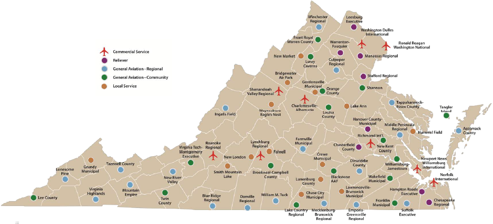
there are General Aviation airports in Southwestern Virginia south and west of Roanoke, but no airport in that region of Virginia offers scheduled commercial passenger service (indicated by )
)
Source: Virginia Department of Aviation, 2013 Virginia Air Transportation System Plan Update
Most Virginia airports are for general aviation rather than commercial passenger service. General Aviation airports allow private planes to land and offer ground services such as refueling. Such airports typically lack air traffic control towers; pilots must pay close attention to other aircraft in the area when taking off or landing using the pilots eyes to maintain separation.
A General Aviation airport in a rural area may not see a lot of traffic, but can be essential to the local economy. Even a small airport offers a fast connection for business executives to reach urban centers. Communities seeking to recruit factories, and other business that might provide jobs and tax revenues, desire to have a nearby airport in order to highlight transportation connections.
Funding to operate General Aviation airports, while small by the standards of major airports with scheduled commercial passenger service such as Washington Dulles, can be a significant challenge for local governments. Funding for capital improvements, including upgrading safety equipment and runways, comes almost entirely from Federal and state grants.
Funding for operations at most General Aviation airport comes from leasing space to Fixed Base Operators that sell gas and other services to pilots, leasing space for parking airplanes at tie-down sites, and tax revenues from local jurisdictions that want some form of airport access. Fixed Base Operators try to recruit someone to operate a flight school, increasing sales of aviation gasoline. There is not enough demand for the average general aviation airport to charge landing fees to visiting planes and there is no passenger tax for commercial flights, which are the two major revenue sources for the nine Virginia airports with scheduled commercial passenger service.
Danville awarded Averett University, a Division III school, the contract to serve as the Fixed Base Operator for the city's general aviation airport in 2021. The private nonprofit university replaced a family-owned business, General Aviation, which had served in that role since 1948.
Averett University had offered training at the airport since 1980. By 2024 almost 120 students were enrolled to earn an aeronautics degree, and the school operated a fleet of 13 small aircraft. The only other academic institutions in Virginia to offer an aeronautics major at the undergraduate level were Liberty University, Hampton University, and Blue Ridge Community College, though there were numerous private for-profit flight schools. Averett's students typically graduated with 250 hours of flight time, and the school employed them afterwards as flight instructors at the Danville Regional Airport teaching undergraduates so they could reach the minimum of 1,000 hours required to start flying as a commercial pilot.
There was no competition for the right to serve as the Fixed Base Operator lease in 2021, or when it was renewed in 2024. The renewal process in 2024 included an assessment by the airport board of the university's financial problems due to misappropriation of funds, which had forced a reduction in pay to employees and a shrinking of classes offered in various degree programs.
General aviation traffic at the Danville Regional Airport was expected to increase with the official opening of Caesars Virginia Casino in Danville on December 17, 2024. In the 2024 contract renewal, Averett University agreed to continue paying $1,500 per month for the contract and use of buildings at the airport for two years, then $2,500 per month. The Fixed Base Operator lease was marginally profitable for the university, and it sought to enhance training opportunities for students more than to maximize revenue. Expenses averaged $1.4 million/year, and revenues were $1.7 million/year.
The renewal process reflected the university's need for facilities to support its aviation major, and the city's difficulty in finding any other organization willing to manage fuel sales and other services at the airport.1
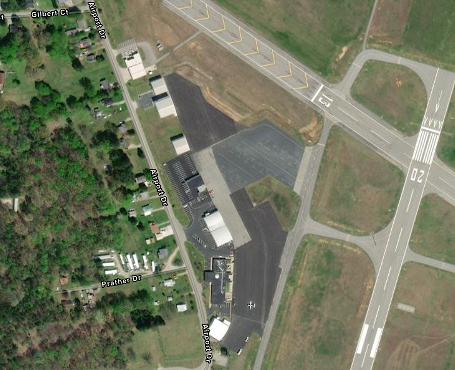
Averett University manages Fixed Base Operations at the Danville Regional Airport
Source: ESRI, ArcGIS Online>
Keeping a General Aviation airport open requires keeping local jurisdictions aware of the benefits of the facility. Local officials are reminded of the costs during each budget cycle.
Mountain Empire Airport is a general aviation airport built in 1958 as a joint project by the counties of Wythe and Smyth, plus the towns of Wytheville, Rural Retreat and Marion. Rural Retreat withdrew from the partnership, and in 2014 Wythe County supervisors questioned the costs vs. benefits of spending about $60,000/year to stay in the Smyth/Wythe Airport Commission. Advocates for maintaining the public airport cited potential economic development advantages, plus the safety benefits of providing a landing site for air ambulance services.2
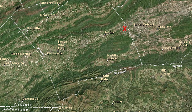
Mountain Empire Airport provides quick access for corporate and financial executives to reach factories and operations in southwestern Virginia
Source: ESRI, ArcGIS Online
The nine airports in Virginia that offer scheduled commercial passenger service today are also General Aviation airports. The three-letter airport codes are modified by adding a "K" in front to define their International Civil Aviation Organization airport code, so the General Aviation identifier for Dulles International Airport is KIAD.
The Federal Aviation Administration (FAA) has identified 3,332 airports in the United States that meet Federal design standards, and classified 3,332 airports in the National Plan of Integrated Airport Systems (NPIAS). In Virginia, 47 qualify for Federal Airport Improvement Program (AIP) funding.
In addition to the nine airports that offer scheduled passenger service, 38 General Aviation airports can obtain Federal grants for capital improvements to reduce safety hazards, enhance navigation, repair facilities, etc.3
The Virginia Department of Aviation has classified 66 public use airports based on their economic and transportation roles. Of that total, 19 are General Aviation Regional airports and 16 are General Aviation Community airports. The state classification system also sets a threshold for authorizing state government funding.
The state agency does not deal with seaplanes. Because there are no licensed, public-use seaplane bases in Virginia, local governments regulate how seaplanes can use waterways for takeoffs and landing and for parking the planes.
14 airports designated "Local" by the Virginia Department of Aviation have limited access to state funding except for safety and preservation projects. All others are eligible for grants to upgrade infrastructure. The state's goals is for all airports not designated "Local" and with more than 500 annual jet operations to upgrade runway lengths to 5,500 feet to to service more turbine-powered jets.4
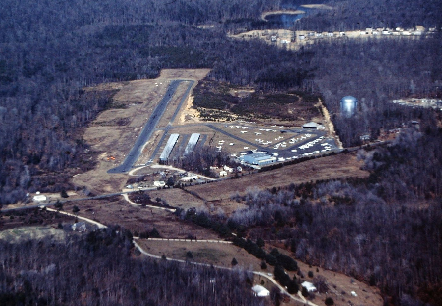
Some of the original General Aviation airports have been closed and developed for retail shopping centers or housing. In Prince William County, the Woodbridge Airport opened in 1959. It had a straight, but not flat, runway.
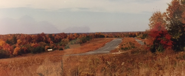
the runway at Woodbridge Airport was cleared, but not flattened, when constructed in 1959
Source: Historic Prince William, View of the Woodbridge Airport in the late 1980s, shortly after it closed
Development of the Lake Ridge community spread westward along Old Bridge Road in the 1980's. Residents supported rezoning the site, in part to provide more shopping opportunities close to home and in part because of safety concerns. Crashes in 1979 and 1985 killed ten people at Woodbridge Airport.
Aircraft operations ceased on May 31, 1987. The site was developed into Dillingham Square with retail stores. The general manager of the Metropolitan Washington Airports Authority noted that General Aviation airports had been disappearing from Northern Virginia:5
- We're not replacing the airports that are being swallowed up by the suburbs.
Washington-Hoover Airport had closed in 1941 after the new National Airport opened. The Hybla Valley Airport, between Alexandria and Mount Vernon, had been considered as a potential site to replace Washington-Hoover Airport until President Roosevelt chose the Gravelly Point location. Hybla Valley Airport also failed to become a destination for zeppelins, and finally closed in 1956. The residential neighborhood that occupies part of the site has streets named after aircraft and aviation companies.6
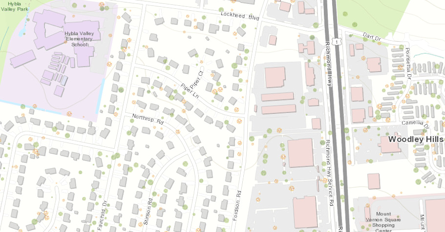
a subdivision at the site of the old Hybla Valley Airport has aviation-based street names
Source: ESRI, ArcGIS Online
Beacon Field Airport closed in 1959, and was replaced by Beacon Mall. Falls Church Airport closed in 1960 and was replaced by Loehmann's Plaza.
The Washington-Virginia Airport at Bailey's Crossroads closed in 1970, ending the challenge that pilots faced of avoiding the drive-in movie theater screen at the end of a runway. One pilot, cutting it too close, left tire marks when he scraped the top of that screen. Skyline Towers has replaced the Washington-Virginia Airport.7
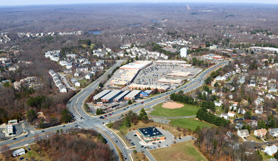
Woodbridge Airport opened in 1959, but after closing in 1987 the site was developed for retail as Dillingham Square
Source: Historic Prince William, Dillingham Square on Old Bridge Road
After the Woodbridge Airport closed, Prince William officials considered constructing a new General Aviation airport on the Cherry Hill peninsula. One option was to build a dike and fill in the shoreline along the Potomac River for a runway. The $73 million cost, and the restrictions on destruction of wetlands, created obstacles too high for the Cherry Hill site.
Prince William County then joined with Stafford County and the City of Fredericksburg to form the Stafford Regional Airport Authority. It opened Stafford Regional Airport (RMN) in 2001. The site, along I-95 in Stafford County, was close enough to Dulles International Airport (IAD) and Washington National Airport (DCA) to qualify for Federal construction funding as a "reliever" airport.
A decade later, after Base Closure and Realignment increased the role of nearby Quantico Marine Corps Base, the first terminal was constructed at the Stafford Regional Airport.8

Source: Stafford Regional Airport
A new Stafford Regional Airport (RMN) opened in Stafford County in 2001. The Federal Aviation Authority approved a runway extension from 5,000 to 6,000 feet in 2013, and construction was completed a decade later.
When first sited, the airport was in an isolated location. As the population continued to grow in Stafford County, the noise of airplane traffic became a public policy issue.
In 2021, the Stafford Regional Airport Authority warned that the approval by Stafford County supervisors of a new age-restricted housing development with 142 homes would generate noise complaints. The site for the Clift Hill development was seven miles from the airport, and outside of the direct flight path of normal airport traffic, but airport officials wanted all purchasers to be notified of the potential for noise.9
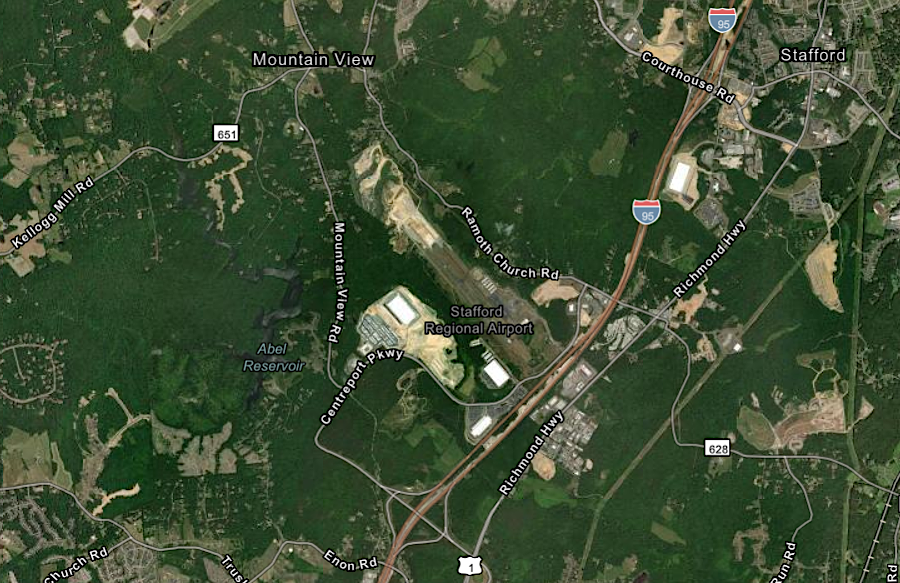
construction of new housing units has slowly reduced the isolation of Stafford Regional Airport
Source: ESRI, ArcGIS Online
Local governments typically lease airport space to a Fixed Base Operator (FBO), who provide aviation fuel and other services. General Aviation airports large enough to support two fixed base operators can provide competitive prices, but local government officials end up negotiating contracts that create conflicts between them.
Chesterfield County approved a 30-year operations agreement and 40-year lease for a second Fixed Base Operator at Chesterfield County Airport in 2018. A private company had serviced planes there since 1991. Small aircraft pilots complained that it prioritized large aircraft, including private jets, and supported a lease to a second company.
The issue became a contentious political football for the elected Board of Supervisors. It directed the Airport Advisory Board to stop making public statements, and one member was replaced in the middle of his term for being too outspoken. In the end, the supervisors authorized the second operator in a 3-2 vote.10
Local governments set property tax rates that airplane owners must pay annually. Setting low property tax rates for airplanes is one way that local jurisdictions compete with each other to attract business to their public airport. At the state level, a one-time 2% sales tax is imposed whenever an airplane is sold in Virginia. If a plane is brought to Virginia and based within the state for 60 days, then the owner must pay the 2% tax to the Virginia Department of Taxation even though no sales transaction has occurred.11
Virginia Highlands Airport at Abingdon started as a small dirt strip in a farmer's field in 1958. An employee of Appalachian Power Company initiated construction of the new field, in order to live in Abingdon and fly to his job site constructing the Clinch River Power Plant in Russell County.
As I-81 was planned, Abingdon and Washington County recognized the economic benefits of having an airport. They arranged for paving one 2,800-foot long, 40-foot wide runway. The narrow, short runway limited use to recreational flying until 1986, when a new 3380-foot long, 75-foot wide runway was completed at Virginia Highlands Airport (VJI). In 1990, the runway was extended to 4,470 feet.
The Airport Commission was reconstituted as the Virginia Highlands Airport Authority in 2007, with Washington County supervisors appointing one representative from each magisterial district. Virginia Highlands Airport generated revenue that exceeded operational costs, largely through fuel sales. In 2021, the airport manager claimed it was one of just a few General Aviation airports in Virginia that operated "in the black."
Efforts to expand the capacity of the airport required decades of lobbying and studies, but resulted in several rounds of funding to extend the runway from 4,471 feet to 5,500 feet. That extension permitted larger executive jets, carrying up to 15 passengers, to bring corporate executives to the local area.
Nearly all of the costs for the airport expansion was funded by Federal and state agencies. The Federal Aviation Authority provided 90%; Virginia's Commonwealth Aviation Fund provided 8%. The local Virginia Highlands Airport Authority had to contribute just about $500,000 towards a $24 million project.12
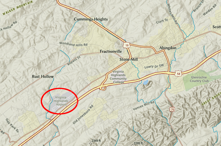
extending the runway to 5,500 feet at Virginia Highlands Airport enabled 15-passenger jets to land near Abingdon in Washington County
Source: ESRI, ArcGIS Online
In 2023, Blue Ridge Regional Airport (MTV) had on average just 66 takeoffs and landings (combined) each day. It also supported two medical helicopters, Air Life and Air Care.
Nonetheless, the Blue Ridge Airport Authority planned to spend $30 million to extend the runway from 5,000 to 6,000 feet, build a new apron so twice as many planes could be parked, extend/shift Airport Road to accommodate the expansion, and construct a new terminal twice the size of the 1987 building.
The Federal government was expected to provide 90% of the $18 million required for most of the runway expansion. The three jurisdictions that compose the Blue Ridge Airport Authority, Patrick County, Henry County, and the City of Martinsville, planned to provide 50% of the $4 million required for the new terminal. The rest would come from the state, but there were hopes to obtain more Federal funding as well.
Justification for the expansion included increasing the number of wealthy visitors flying into the airport to go to the Primland Resort and Martinsville Speedway. The region's economic development plans included attracting new manufacturing industries that would provide high-paying jobs and increase the local tax base. Creating one of the few General Aviation airport runways 6,000 feet long, a minimum length for some executive jets, was expected to give the area a competitive advantage in recruiting new companies.
Expanding the apron tripled capacity to park jets at the small airport, up to 25-35 at one time. When talking about the planned new terminal, the president of the Martinsville Henry County Economic Development Corporation said:13
- We consider it our front door for people who are traveling by plane.
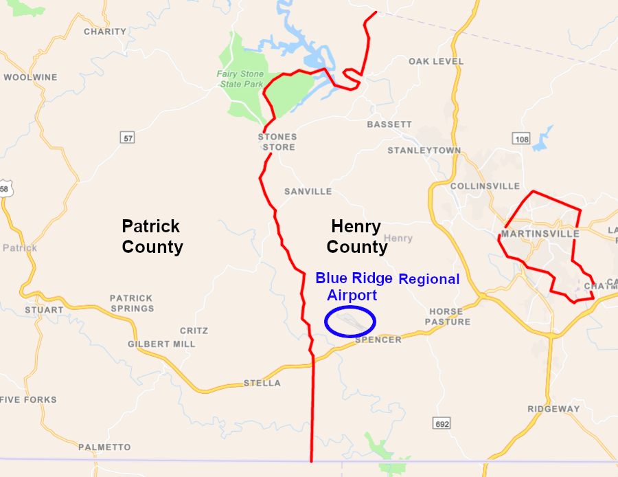
the Blue Ridge Airport Authority is composed of members from Patrick County, Henry County, and the City of Martinsville
Source: ESRI, ArcGIS Online
Links
References
1. "Averett University debuts first twin-engine plane for growing aeronautics program," Cardinal News, March 22, 2024, https://cardinalnews.org/2024/03/22/averett-university-debuts-first-twin-engine-plane-for-growing-aeronautics-program/; "Averett's airport operation gives students a one-of-a-kind experience," Cardinal News, December 1, 2022, https://cardinalnews.org/2022/12/01/averetts-airport-operation-gives-students-a-one-of-a-kind-experience/; "Schools, Colleges, and Institutions," Virginia Department of Aviation, https://doav.virginia.gov/schools-colleges-universities/
(last checked December 16, 2024)
2. "Airport supporters address Wythe board," Wythe News, August 15, 2014, http://www.swvatoday.com/news/smyth_county/article_afa4ec36-24ba-11e4-b38a-0017a43b2370.html (last checked August 15, 2014)
3. 2017-21 National Plan of Integrated Airport Systems (NPIAS) Report, Federal Aviation Administration, https://www.faa.gov/airports/planning_capacity/npias/reports/media/NPIAS-Report-2017-2021-Appendix-B-Part-6.pdf; "List of NPIAS Airports with 5-Year Forecast Activity and Development Cost (Appendix A)," Federal Aviation Administration, https://www.faa.gov/airports/planning_capacity/npias/reports/media/NPIAS-Report-2017-2021-Appendix-A.xlsx (last checked December 21, 2016)
4. "Virginia Commercial Air Service Strategic Review," Virginia Department of Aviation, December 2015, pp.4-5, http://doav.virginia.gov/Downloads/Studies/Strategic%20Review%202015/DOAV%20Strategic%20Review%20Final%20December%202015%20Reduced3.pdf; "Virginia Air Transportation System Plan Update (2016)," Virginia Department of Aviation, p.100, http://www.doav.virginia.gov/VATSP_update_2016.htm; "Virginia Air Transportation System Plan Update - Facilities Objectives Analysis," Virginia Department of Aviation, 2016, pp.98-99, http://www.doav.virginia.gov/Downloads/Studies/VATSP%20Update%202016/600%20DOAVAS%2020160406%20VATSP%20Update-04%20Chapter%203%20Facility%20Objectives_Web_acsbl.pdf; "Frequently Asked Questions," Virginia Department of Aviation, http://www.doav.virginia.gov/faqs.htm (last checked November 21, 2018)
5. "Woodbridge Airport," Historic Prince William, http://www.historicprincewilliam.org/county-history/structures/woodbridge-airport.html; "Small Airports Nosediving In Number," Washington Post, September 21, 1987, p.F1; "3 Killed When Plane Trying to Land Hits 2nd at Woodbridge," Washington Post, June 8, 1979, C1; "Lawyer, Horse Trainer Die in Woodbridge Crash," Washington Post, August 14 1985, p.B4; "5 Die as Small Plane Crashes; Cause Sought for Prince William County Accident," Washington Post, May 27, 1985, p.B1; "Off to That Great Hangar in the Sky; Pilots Say Goodbye to Pr. William Airport Sold to Developers," Washington Post, June 1, 1987, p.D1 (last checked March 22, 2018)
6. "Helium... Hydrogen... Hybla Valley History!," Hybla Valley Airport, http://www.hyblavalleyairport.com/history.html; "The Historic Roadside Marker," Hybla Valley Airport, http://www.hyblavalleyairport.com/home.html; "The Historic Roadside Marker," Beacon Filed Airport, http://www.beaconfieldairport.com/ (last checked March 22, 2018)
7. "Falls Church Airpark, Falls Church, VA," Abandoned & Little-Known Airfields: Virginia: Western Fairfax County, http://www.airfields-freeman.com/VA/Airfields_VA_Fairfax_W.htm; "Crossroads Airport / Washington-Virginia Airport, Bailey's Crossroads, VA," Abandoned & Little-Known Airfields: Virginia: Northeastern Fairfax County, http://www.airfields-freeman.com/VA/Airfields_VA_Fairfax_NE.htm (last checked March 22, 2018)
8. "Officials in Prince William Find Possible Airport Location," Washington Post, February 29, 1988, p.C5; "New Stafford airport terminal a sign of region's growth," WTOP, October 10, 2012, https://wtop.com/news/2012/10/new-stafford-airport-terminal-a-sign-of-regions-growth/ (last checked March 22, 2018)
9. "Stafford airport wants the county to warn new neighbors of noise", Potomac Local, January 14, 2021, https://potomaclocal.com/2021/01/14/stafford-airport-wants-the-county-to-warn-new-neighbors-of-noise/; "Airport History," Stafford Regional Airport, https://staffordairport.com/airport-authority/; "Stafford Regional Airport Runway Extension," Stafford Regional Airport, September 2018, https://new.staffordairport.com/wp-content/uploads/2022/03/129293128.pdf (last checked October 16, 2023)
10. "Old aviation vs. new aviation: Why a proposal for the Chesterfield Airport was politicized," Richmond Times-Dispatch, November 17, 2018, https://www.richmond.com/news/plus/old-aviation-vs-new-aviation-why-a-proposal-for-the/article_932c145d-2728-516b-bc7a-5648ebaf3b61.html (last checked November 19, 2018)
11. "Aircraft Licensing Frequently Asked Questions," Virginia Department of Aviation, http://www.doav.virginia.gov/licensing_aircraft%20faqs.htm (last checked November 21, 2018)
12. "Watch Now: Virginia Highlands Airport runway expansion plans continue," Bristol Herald-Courier, February 21, 2021, https://heraldcourier.com/news/watch-now-virginia-highlands-airport-runway-expansion-plans-continue/article_a49be05e-488c-5b73-8a18-583c2caf8182.html (last checked October 16, 2023)
13. "$20 million expansion of Blue Ridge Regional Airport continues, with a longer runway and new terminal still to come," Cardinal News, October 16, 2023, https://cardinalnews.org/2023/10/16/20-million-expansion-of-blue-ridge-regional-airport-continues-with-a-longer-runway-and-new-terminal-still-to-come/; "About," Blue Ridge Rgional Airport, https://www.flyblueridge.com/about-us; 'Henry County airport expansion underway," Virginia Business, March 28, 2024, https://www.virginiabusiness.com/article/henry-county-airport-expansion-underway/ (last checked April 12, 2024)
Transportation: From Feet to Teleports
Virginia Places