Erie/Rickahocan/Westo in Virginia
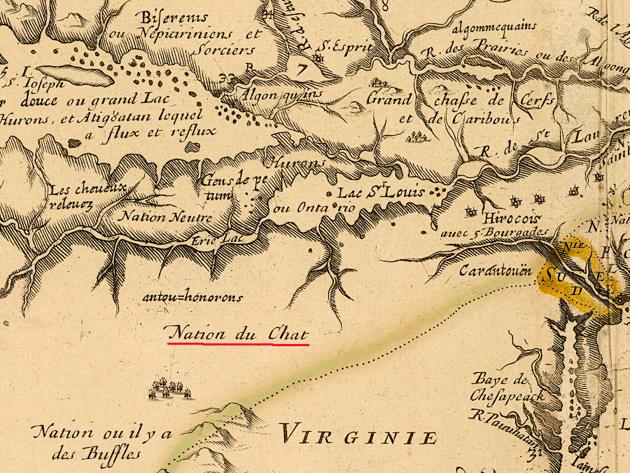
until displaced in 1654 by the Beaver Wars, the Erie (Nation du Chat) lived near Lake Erie and north of the Ohio River
Source: John Carter Brown Library at Brown University, Le Canada faict par le Sr de Champlain. ou sont la Nouvelle France la Nouvelle Angleterre (by Samuel de Champlain, 1664)
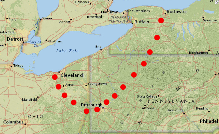
The territory of the Erie before the 1660's was on the southern shore of Lake Erie, somewhere between modern-day Rochester, New York and Cleveland, Ohio:1
- The probable true boundaries of the territory of the Erie were the lake on the north, the Genesee River on the east, the Allegheny River on the south, and the Grand and Mahong Rivers on the west.
In the Iroquoian language, the full name for the Erie was "Erieronon" or "Eriehaga." That meant "long tail," and probably referred to mountain lions/cougars or raccoons. French Jesuits and traders called them "La Nation du Chat" (chat = cat in French). The Erie were also known by other Native American groups as the Alligewi or the Olighin, which is the source for "Allegheny," and as the Riquehronnon or Eriegoneckkak.2
English colonists expanding from their initial Jamestown settlement forced Native Americans to relocate. The Anglo-Powhatan wars in 1609, 1622 and 1644 led to Algonquian-speaking tribes being pressured to abandon long-occupied townsites in Tidewater
Being forced to move was not a new challenge. Multiple population changes occurred long before Europeans arrived. Groups migrating from the east and north, plus wars between resident groups, displaced old residents as new occupiers seized territory. A remnant of the Erie nation was pushed by the Haudenosaunee into Virginia soon after the colonists killed Opechancanough in 1646 and destroyed the paramount chiefdom previously controlled by Powhatan.
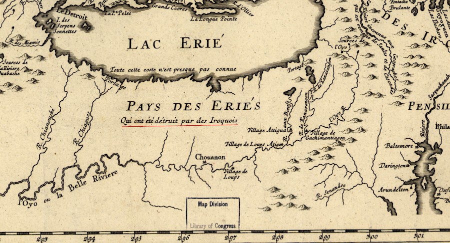
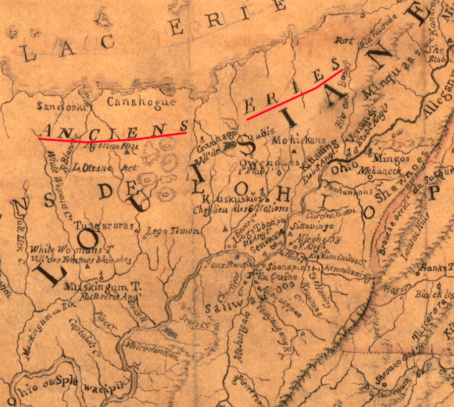
the Erie dominated the area between the Ohio River and Great Lakes until they were destroyed ("detruit") by the Iroquois
Source: Library of Congress, Partie occidentale de la Nouvelle France ou du Canada (by Jacques Nicolas Bellin, 1755); John Carter Brown Library at Brown University, A Map of a Large Country Newly Discovered in the Northern America Situated between New Mexico and the Frozen Sea (by Louis Hennepin, Louis, 1698)
In the 1600's the Haudenosaunee, five Iroquois-speaking tribes (Mohawk, Oneida, Onondaga, Cayuga and Seneca) living south of the St. Lawrence River and west of the Hudson River in what is now New York, obtained weapons from the French, Dutch, and English. The Europeans traded guns for furs, especially deer hides. The guns helped the Native Americans bring more product for sale to the European settlements near the Atlantic Ocean shoreline.
Because the Europeans settled near the Haudenosaunee, they were some of the first tribes to trade with the Dutch (then English) at Albany. Through trade, the Haudenosaunee obtained guns before other tribes. With enhanced military power, they blocked other tribes from direct sales to the European traders and established themselves as middlemen.
The Haudenosaunee also expanded their control over the fur trade by seizing control of territory west of the Iroquois homeland and intercepting furs intended for sale at Montreal or Albany. The Haudenosaunee won the brief but intense Beaver Wars in the 1640's-1660's. They accomplished their objective to increase their population (depleted by a smallpox epidemic in 1638-40) by adopting captives, and to "extend the rafters of the longhouse" by gaining control over hunting territory.
Led by the Seneca, they defeated the Huron-Wendat to the west in 1642-1649 and the Neutral Nation (Attiwandaron) in 1650-51. In 1651 on the southern edge of Haudenosaunee territory, the Mohawk and Oneida started attacking the Susquehannocks, the main ally of the Erie. After meeting stiff resistance, the Haudenosaunee made peace with the French at Quebec in 1753 in order to free up more warriors for attacks on their Native American neighbors.
The Erie incorporated refugees from the Huron-Wendat, Neutral, Nipissing, Petun, and other groups who had been defeated by the Haudenosaunee. The five Iroquois tribes continued to extend their power westward, and between 1651-1656 they conquered the Erie. Many were then adopted by the Seneca, whose population had been reduced by the warfare.
Some bands of Erie fled after their towns were destroyed in 1656, but the Erie no longer survived as an organized nation. The Haudenosaunee continued to confront bands of Erie and the last such group, living in Pennsylvania, surrendered in 1680.
Most Erie that dispersed in 1656 consolidated with remnants of other groups that had been conquered by the Haudenosaunee. Groups of people from various tribes who stayed near the Ohio River evolved into the Mingo, a name used by Algonquian speakers to refer to Iroquoian speakers. Some of the Mingo were actually Delawares, an Algonquian-speaking tribe displaced from eastern Pennsylvania and Maryland. The Mingo also included disaffected groups of the Seneca who left New York, some of whom were descendants of tribes adopted into the Seneca after the Beaver Wars. One of the major Mingo settlements was Mingo Bottom at modern Steubenville, Ohio.3
After the United States forced Native Americans out of Ohio in 1830, survivors of the Erie nation ended up in Oklahoma. They are organized today as the Seneca-Cayuga Nation.4
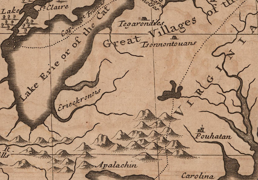
the Erie lived west of the Iroquois, and were conquered by them between 1651-1682 during the Beaver Wars
Source: ESRI, ArcGIS Online
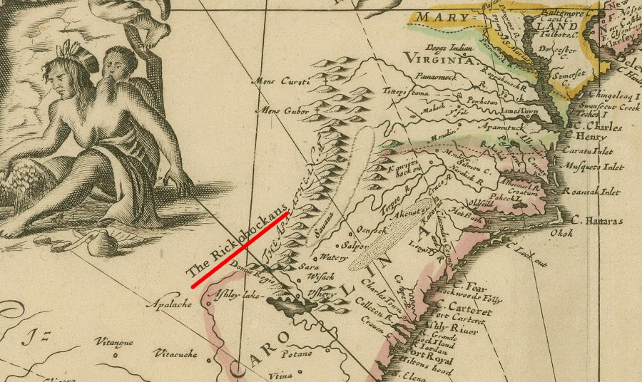
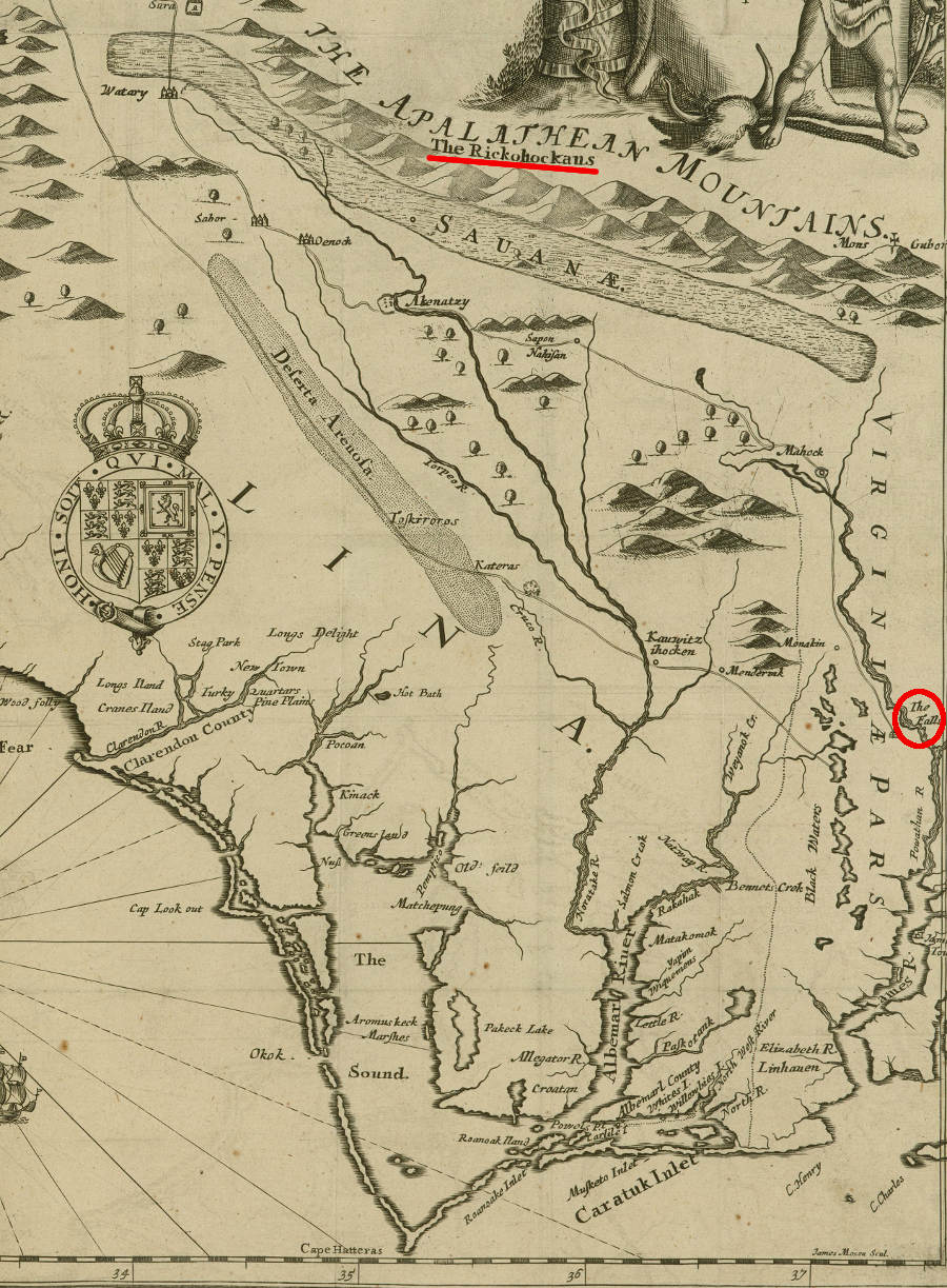
After the defeat in 1656, 600-700 of the Arrigahaga/Rigueronon subtribe of the Erie migrated to Virginia and settled on the Fall Line of the James River. The English colonists called the new arrivals the Rickahocan (or Ricahecrian), a term indicating they came from over the mountains.5
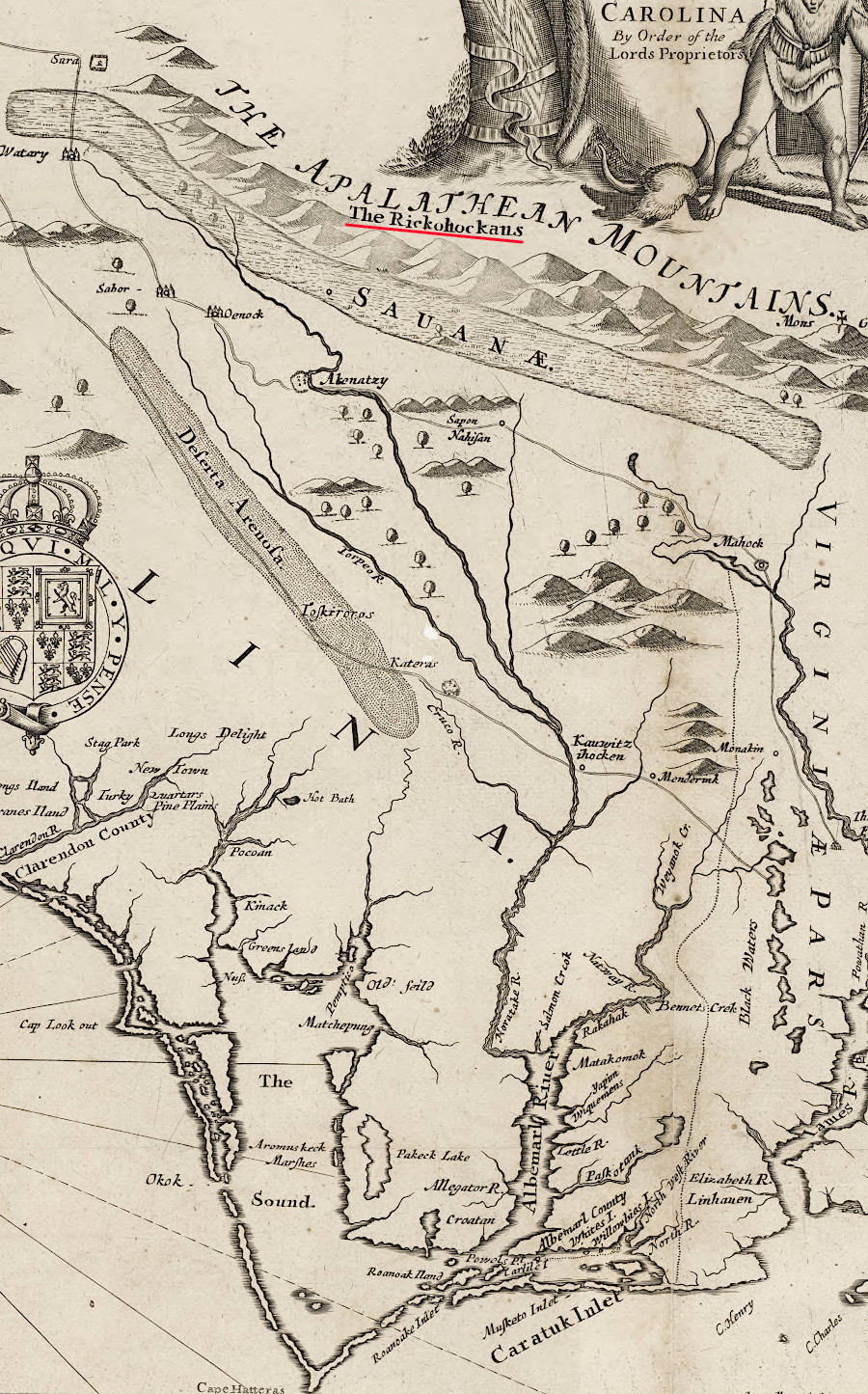
"Rickahocan" meant the people came from "over the mountains"
Source: University of North Carolina, A new discription of Carolina by the order of the Lords Proprietors (John Ogilby, 1671)
The "foreign" group appeared when Virginia's leadership had been disrupted by the English Civil War and Puritan leaders had forced Gov. William Berkeley to leave office. Governor Edward Digges and his Council were concerned about the presence of a Native American group that was not submissive to the English, and directed Colonel Edward Hill to negotiate a peaceful alliance with the Rickahocans.
the group of Eries who migrated to Virginia in 1656, after being displaced by the Iroquois, were called the Rickahocans by English colonists
Source: John Carter Brown Library at Brown University, A New Map of the English Plantations in America (from the Blathwayt Atlas, 1673)
At the same time, the Puritan leaders invoked the terms of the 1646 treaty that had ended the Third Anglo-Powhatan War. That treaty required the Pamunkey, the main tributary tribe from Opechancanough's former paramount chiefdom, to supply warriors in case there was a need to fight. The Pamunkey probably viewed the Rickahocans as a threat as well, rivals for hunting territory and control of trade with the English.
Despite his instructions, Colonel Edward Hill chose to fight rather than engage in diplomacy. The 1656 battle was between about 100 Rickahocans and an equal number of colonists. plus tributary allies. The Pamunkey attacked first, but Colonel Hill failed to bring the colonial fighters to reinforce them. The Pamunkey weroance, Totopotomoy, and most of his warriors were killed. So much blood was spilled that the local stream became known as Bloody Run, and the fight was called the Battle of Bloody Run.
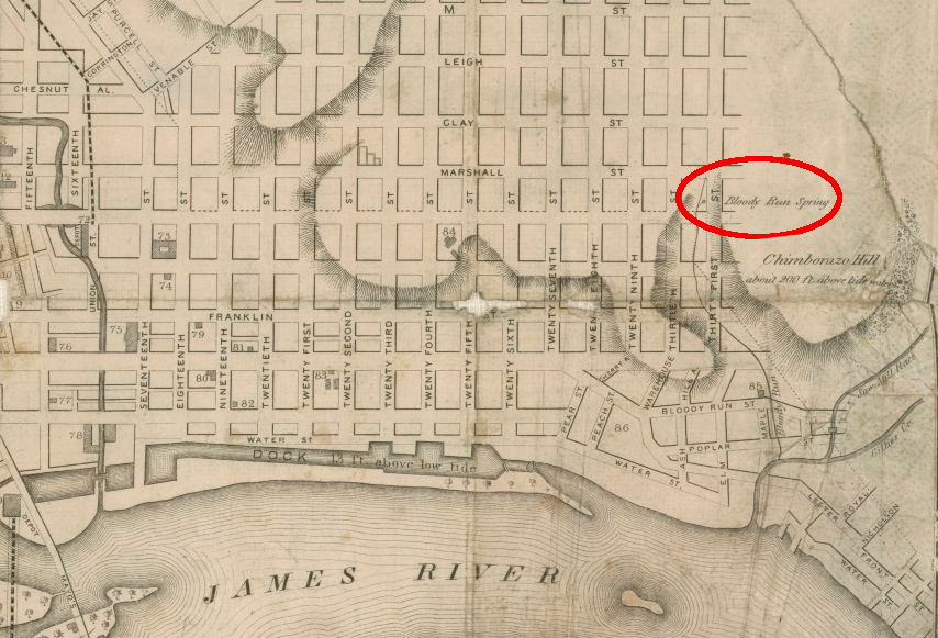
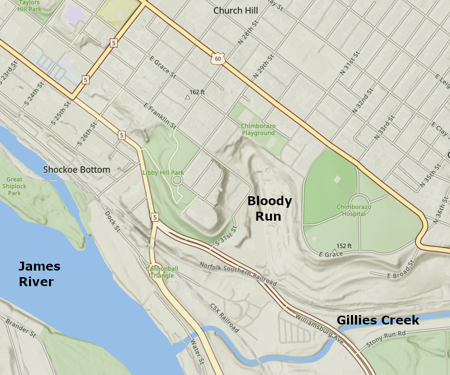
Bloody Run flowed from a spring between Libbie Hill and Chimborazo Hill to Gillies Creek
Source: Virginia Memory, Map of Richmond (by William Sides, 1856); ESRI, ArcGIS Online
The stream flowed down the south side of what later was named Chimborazo Hill to Gillies Creek. In 1884, Bloody Run was buried in a stormwater pipe by the City of Richmond as development expanded. A modern historical sign marks the location of the battle.6
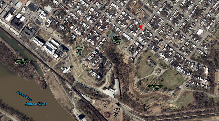
Bloody Run Spring, at the southwest corner of East Marshall and North 31st streets, is now buried
Source: ESRI, ArcGIS Online
The Rickahocans/Westos victory over the English and their Native American tributary fighters at the Battle of Bloody Run in 1656 had an impact 20 years later in Virginia. Cockacoeske, the wife of Totopotomoy, became the leader of the Pamunkey after he was killed. At the start of Bacon's Rebellion in 1676, Governor Berkeley demanded that Cockacoeske supply warriors to fight, invoking the 1646 treaty again. She repeated the Pamunkey complaint about receiving no compensation after Bloody Run and committed to provide just a token number (12) of men.7
After the 1656 battle, the English and Rickahocan chose to trade with each other rather than to continue to fight. The English began to refer to the group as the Westo. The well-armed Westo captured Native Americans from other tribes and sold those captives to Abraham Wood and other traders. The captives were sold to Virginia tobacco growers, or shipped to Caribbean islands, as enslaved workers.
Through the slave trade, the Westo obtained guns, ammunition, and gunpowder that enabled them to maintain their dominance. They raided as far south as the Spanish mission towns in Florida.
Charles II was restored to the throne in 1660 and in Virginia, Governor Berkeley regained his office. He continued to trade with the Westo rather than try to force them into tributary status.8
In 1670, John Lederer met four "stranger-Indians" at Akenatzy, an island occupied by Occaneechi (likely Ocanneechi Island at the confluence of the Dan and Staunton Rivers), during his second westward exploration from Tidewater Virginia. Lederer understood the strangers were Rickahocans, the last of a group which had fled south. With optimism that he may have found a path to the Pacific Ocean, Lederer speculated they had come from a land with a waterway that connected to California:9
- ...the Nation of Rickohockans, who dwell not far to the Westward of the Apalataean Mountains, are seated upon a Land, as they term it, of great Waves; by which I suppose they mean the Sea-shore.
The colonial explorer was intrigued by a mineral the used to paint the Rickahocan faces, and of course was interested in learning the geography of lands to his west and north. After the surprising murder of the Rickahocan visitors by the Occaneechi, for no apparent cause, Lederer decided to move on:10
- The next day after my arrival at Akenatzy, a Rickohockan Ambassadour, attended by five Indians, whose faces were coloured with Auripigmentum (in which Mineral these parts do much abound) was received, and that night invited to a Ball of their fashion; but in the height of their mirth and dancing, by a smoke contrived for that purpose, the Room was suddenly darkned, and for what cause I know not, the Rickohockan and his Retinue barbarously murthered. This struck me with such an affrightment, that the very next day, without taking my leave of them, I slunk away with my Indian Companion.

explorer John Lederer encountered Native Americans west of the Blue Ridge that he labelled "Rickohocans" (note: west is towards top of the map)
Source: University of North Carolina, The Discoveries Of John Lederer
The Occaneechi obtained firearms from Virginia and Carolina traders, and by the 1670's they challenged the Westo's control of the fur trade with Virginia colonists. The Rickahocan/Westo chose to leave Virginia and moved south to the Savannah River. The tribes there lacked guns, so the Westo could establish dominance.11
Around the Savannah River, the Westo quickly became dominant because other tribes lacked guns. The Westo were able to seize captives from tribes living further south near the Spanish in Florida, then sell the captives to be enslaved by the Georgia and South Carolina colonists. For about a half-dozen years, the Westo controlled the deer hide trade to Savannah and Charles Town.
The Westo effectively blocked the English in Charles Town from dealing with other tribes to the west. The Lords Proprietors of Carolina, who founded Charles Town in 1670, initially decided (like Governor Berkeley in Virginia) that it was more economical to trade rather than to fight the Westo. The colonial leaders eventually changed their minds. They armed the Savannah tribe, a group of Shawnee who had also migrated south, and the Savannah helped the colonists defeat the Westo.
The 1680 Westo War ended the monopoly on the trade with tribes in the interior. The captured Westo were sold as slaves for the sugar plantations in the Caribbean. Those who escaped blended into the Coweta tribe and eventually were absorbed into the Creek confederacy. The Savannah assumed the role of the middleman facilitating trade from people living further west.12/a>
the Erie lived west of the Iroquois until being defeated and scattered in the Beaver Wars
Source: Library of Congress, Map showing French occupation of the Ohio Valley: taken from Mr. Robert's Atlas universel, Paris 1755: based on Christopher Gist's surveys made 1751 (John G. Ruple, 1882)
Links
- American Anthropologist
- Erie Indian Moundbuilders Tribal Nation
- First Nations
- SciWay
- Seneca-Cayuga Nation
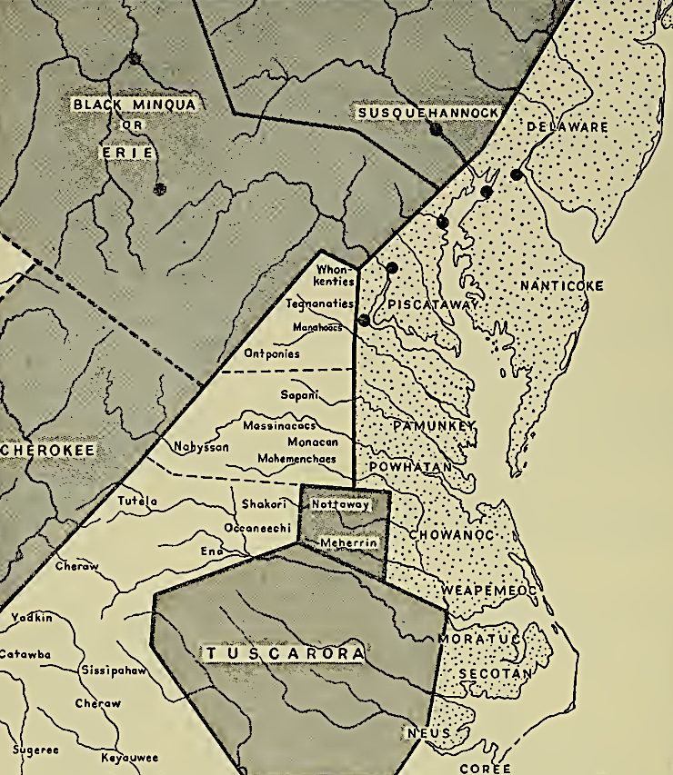
the Erie and the Massawomecks may have morphed into the Black Minquas, one of several Iroquoian-speaking groups who lived in the shaded areas
Source: Bernard G. Hoffman, Observations on Certain Ancient Tribes of the Northern Appalachian Province (p.234)
References
1. Chuck Hamilton, "Lost Nation of the Erie Part 1," The Chattanoogan, January 21, 2016, https://www.chattanoogan.com/2016/1/21/316430/Lost-Nation-of-the-Erie-Part-1.aspx (last checked March 5, 2025)
2. "The Erie Indians," Avon Historical Society, https://www.avonhistory.org/166/The-Erie-Indians; Charles C. Kolb, "The 'Alligewi' of Western Pennsylvania," The Journal of Erie Studies, Volume 12, Number 1 (Spring, 1983), https://journals.psu.edu/eriestudies/article/view/186; Stephen A. Runkle, "Native American Waterbody and Place Names Within the Susquehanna River Basin and Surrounding Subbasins," Susquehanna River Basin Commission, Publication 229, September 2003, p.40, https://www.srbc.gov/our-work/reports-library/technical-reports/229-native-american-names/docs/native-american-names.pdf; Chuck Hamilton, "Lost Nation of the Erie Part 1," The Chattanoogan, January 21, 2016, https://www.chattanoogan.com/2016/1/21/316430/Lost-Nation-of-the-Erie-Part-1.aspx (last checked March 5, 2025)
3. Eric E. Bowne, The Westo Indians: Slave Traders of the Early Colonial South, University of Alabama Press, 2005, p.39, https://books.google.com/books?id=t3CtB3yXk00C; Michael McCafferty, Native American Place Names of Indiana, University of Illinois Press, 2008, p.212, https://books.google.com/books?id=n8uvs6Qw3pEC; "Lost Nation of the Erie Part 1," The Chattanoogan, January 21, 2016, http://www.chattanoogan.com/2016/1/21/316430/Lost-Nation-of-the-Erie-Part-1.aspx; "Wendat (Huron)," The Canadian Encyclopedia, https://www.thecanadianencyclopedia.ca/en/article/huron; "The Neutral Confederacy," The Canadian Encyclopedia,, https://www.thecanadianencyclopedia.ca/en/article/neutral; "Iroquois Wars," The Canadian Encyclopedia, https://www.thecanadianencyclopedia.ca/en/article/iroquois-wars; "The Original Inhabitants of Avon," Avon Historical Society, https://www.avonhistory.org/164/The-Original-Inhabitants-of-Avon; "Mingo," e-WV: The West Virginia Encyclopedia Online, https://www.wvencyclopedia.org/entries/1771 (last checked April 7, 2025)
4. "Erie," The Encyclopedia of Oklahoma History and Culture, https://www.okhistory.org/publications/enc/entry?entry=ER002 (last checked April 6, 2025)
5. April Lee Hatfield, Atlantic Virginia: Intercolonial Relations in the Seventeenth Century, University of Pennsylvania Press, 2004, p.25, https://books.google.com/books/about/Atlantic_Virginia.html?id=KELg0NCW5-sC; "Lost Nation of the Erie Part 1," The Chattanoogan, January 21, 2016, http://www.chattanoogan.com/2016/1/21/316430/Lost-Nation-of-the-Erie-Part-1.aspx; Chuck Hamilton, "The Lost Nation of the Erie By Chuck Hamilton Part 2," The Chattanoogan, January 22, 2016, https://www.chattanoogan.com/2016/1/22/316562/Lost-Nation-of-the-Erie---Part-2.aspx (last checked April 6, 2025)
6. "Battle of Bloody Run-Richmond," Clio, https://www.theclio.com/web/entry?id=21759; "The Battle of Bloody Run," Church Hill People's News, December 2, 2014, https://chpn.net/2014/12/02/the-battle-of-bloody-run/; Robbie Franklyn Ethridge, Sheri Marie Shuck-Hall, Mapping the Mississippian Shatter Zone: The Colonial Indian Slave Trade and Regional Instability in the American South, University of Nebraska Press, 2009, pp.90-91, https://books.google.com/books?id=dFNI9935DNwC (last checked January 12, 2018)
7. Alfred A. Cave, Lethal Encounters, Praeger, 2011, p.151, https://books.google.com/books/about/Lethal_Encounters_Englishmen_and_Indians.html?id=teEOqdkXMVYC (last checked January 11, 2018)
8. Kristalyn Shefveland, "Indian Enslavement in Virginia," Encyclopedia Virginia, Virginia Foundation for the Humanities, April 7, 2016, https://www.encyclopediavirginia.org/Indian_Enslavement_in_Virginia (last checked April 6, 2025)
9. John Lederer, The Discoveries of John Lederer, 1672, p.14, posted online by Research Laboratories of Archaeology, University of North Carolina at Chapel Hill, http://rla.unc.edu/Archives/accounts/Lederer/Lederer.html; Eric E. Bowne, The Westo Indians
Slave Traders of the Early Colonial South, 2005, p.80, https://www.google.com/books/edition/The_Westo_Indians/t3CtB3yXk00C (last checked April 6, 2025)
10. John Lederer, The Discoveries of John Lederer, 1672, p.14, posted online by Research Laboratories of Archaeology, University of North Carolina at Chapel Hill, http://rla.unc.edu/Archives/accounts/Lederer/Lederer.html (last checked January 12, 2018)
11. Kristalyn Shefveland, "Indian Enslavement in Virginia," Encyclopedia Virginia, Virginia Foundation for the Humanities, April 7, 2016, https://www.encyclopediavirginia.org/Indian_Enslavement_in_Virginia; Eric E. Bowne, The Westo Indians
Slave Traders of the Early Colonial South, 2005, pp.80-82, https://www.google.com/books/edition/The_Westo_Indians/t3CtB3yXk00C (last checked April 6, 2025)
12. Spencer Tucker, James R. Arnold, Roberta Wiener, The Encyclopedia of North American Indian Wars, 1607 1890: A Political, Social, and Military History, ABC-CLIO, 2011 p.841, https://books.google.com/books?id=JsM4A0GSO34C; "Westo Indians," Peach State Archaeological Society, https://peachstatearchaeologicalsociety.org/index.php/11-culture-historic/402-westo-indians; "Westo Indians," New Georgia Encyclopedia, https://www.georgiaencyclopedia.org/articles/history-archaeology/westo-indians/ (last checked April 6, 2025)
refugees of the Erie called "Rickohocans" migrated from the Great Lakes to the headwaters of the Tennessee River, as well as to the Falls of the James River
Source: John Carter Brown Library at Brown University, A New Discription of Carolina By Order of the Lords Proprietors (published by John Ogilby from John Lederer's map, 1672)
"Indians" of Virginia - The Real First Families of Virginia
Virginia Places