Prince William County spent nearly $1 million to repair Lake Jackson Dam after the 2001 earthquake in Mineral, Virginia
Prince William County spent nearly $1 million to repair Lake Jackson Dam after the 2001 earthquake in Mineral, Virginia
Most Americans will live if several different places during in their lives. Once you develop your skills for getting the sense of Virginia, you can apply those skills to lots of other places. (Think the professionals who choose the locations for fast food restaurants, Wal*Marts, shopping malls, etc. focus on how people shop in just one state?)
Get savvy about why you see things where you see them, the why of where. Don't take places for granted. The Geography of Virginia class will increase your capacity to analyze geographic patterns, to explain the story behind what you see in TV news/local newspaper articles. You'll learn how to use research sources on the Internet to make maps, access data, and discover the official government plans for the future of Virginia places.
We'll start the class with a review of Northern Virginia, including physical and cultural characteristics of that region. We'll explore the political boundaries of the state, and dig into the physical geography, including the geology and watersheds and biogeography of Virginia. We'll touch on why counties and cities developed at different times... and of course, we'll get stuck in traffic.
We'll look at the initial transportation patterns of Virginia settlement. You'll discover the origins of Braddock Road, Route 123, Route 50, Route 15, Interstate 95 and Interstate 81, and a series of other highways where you may have wondered "Who were the engineers that laid out this crazy road!?"
That will prepare you to understand how the physical geography affected various military campaigns in Virginia, including that "late unpleasantness" in 1861-65. We'll look at how the state capital has migrated over the years before settling in Richmond in 1865, and the different ways in which people define the regions of Virginia.
Virginia is not homogeneous, physically or culturally, so we'll spend considerable time exploring the natural and historical resources in different regions of the state. When we look at Virginia's political geography, we'll see what makes the whole state different from, say, Massachusetts.
Ugh, Massachusetts! The Separatists ("Pilgrims") were latecomers, arriving 13 years after Jamestown was settled. Don't believe their propaganda about holding the First Thanksgiving. Berkeley Plantation on the James River claims that honor, along with production of the first bourbon. (You believe everything you read, right?)
Of course, if the Pilgrims and Puritans in Massachusetts were latecomers, the English who started Jamestown in 1607 were not the first arrivals either. The first First Families of Virginia (the "FFV's") appeared over 15,000 years ago. Even the Spanish tried to settle Virginia before the English, but the Jesuits failed in 1570-71. The aristocratic colonial gentry that developed fully in the 1700's led to Virginia producing four of the first five presidents of the United States, but the demographic story of the colony/state involves far more than just famous FFV's. The first documented arrival of Africans was in 1619, and people of color constituted 40% of the population in 1790.
Virginia's countryside offers natural beauty for tourists and a productive agricultural base. It's hard to find a farmer in Northern Virginia who gets their primary income from agriculture... but there are still many places in Virginia where farmer tans outnumber golfer tans.
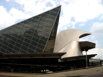
Taubman Museum of Art (Roanoke)
(with a design described locally as "what it looked like after the Flying Nun hit the mountains")
When you drive down the highway, pay attention to what is growing in the fields. You'll find corn, hay, and soybeans almost everywhere. "Bright" tobacco is grown primarily in south-central Virginia, but "burley" tobacco is preferred in the Southwest. Ever notice how the wineries seem to be located close to the highways - do Viognier grapes (the official wine grape of Virginia) need exhaust fumes to ripen?
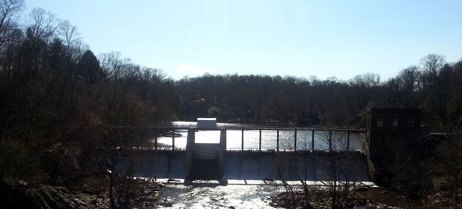
The Fall Line determined the location of many of Virginia's initial industrial sites, but how does that relate to textile manufacturing in Danville? Why did the tiny community of Fries (sometimes pronounced Fryze in the summer, Freeze in the winter) have a textile mill? Why did it close in 1989, after operating for 86 years?
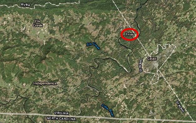
Fries developed as a mill town after a dam was built at Bartlett Falls on the New River in 1901
Source: ESRI, ArcGIS Online
The geography of Virginia's solid waste has its own story. Trash is big business - did you know Virginia imports more garbage than all but one other state? Why does New York City ship its garbage to Berkeley Plantation, and why do politicians talk about importing garbage as a problem - but don't stop it? The Virginia is for Lovers advertisements has never used landfills as a romantic background, but this Geography of Virginia class offers more than just a tourist-y tour of the state.
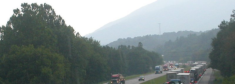
why are there so many trucks clogging up I-81, compared to I-66 or I-64?
Anyone who has spent time in Northern Virginia quicky learns to predict where traffic jams will occur, but places change over time. Tyson's Corner will morph into a mixed use community over the next 20 years, with concentrations of housing (and even a park or two) as well as office buildings.
Suburban sprawl may expand west from Richmond and transform eastern Powhatan County as it has Chesterfield County. Then again, if the next generation of young workers prefers to live in an urban setting *and* if Richmond's school system improves enough to retain those residents when children reach school age, then revitalization of Richmond's urbanized community of Manchester may reduce the demand for new subdivisions on the city's periphery.
The same could happen in Northern Virginia as Fairfax County rezones areas first developed during the "baby boom" to allow higher-density development, and offers better bus/light rail transit to areas that are not near a Metro station. Speculative development in Loudoun, Prince William, and Stafford counties could become less profitable. On the other hand, self-driving cars with intelligent highways could minimize the pain of driving to work and increased telecommuting could make suburban living even more attractive. A successful real estate developer is a geographer who bets correctly on future land use and transportation patterns, buying land by the acre and selling it later by the square foot.
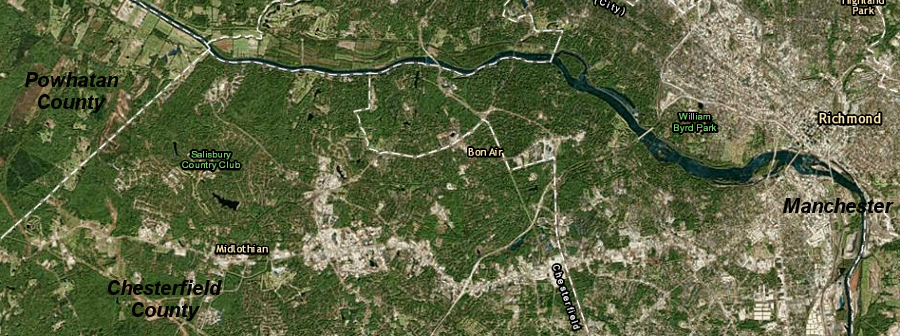
suburban sprawl and urban population decline was facilitated by highway construction after World War II, but that pattern of growth could change
Source: ESRI, Earth Observatory, ArcGIS Online
Home buyers who fail to anticipate future land use patterns can see economic consequences too. If new development migrates to Silver Line stations in Loudoun County, will housing prices stop climbing in Prince William County? If you buy a house within a quarter-mile of a Virginia Railway Express (VRE) station, will its price increase as fast as a house within a half-mile of a Metrorail station?
Can you select the next place in Virginia that ought to become a state park? Can you identify a 1950's subdivision where split-level homes ought to be preserved as an architectural/historical site, or a 1970's townhome development with vinyl siding that should be protected as a historical district?
Can you predict where the next bridge across the Potomac River will be constructed? Will improved passenger rail really make a significant difference in how places grow? Will Norfolk/Virginia Beach thrive even if plans for a high speed passenger rail connection never get implemented, or will Hampton Roads become a urban cul-de-sac on the fringe of the Boston-Washington corridor? For that matter, if sea levels continue to rise, when will Norfolk drown and when will Virginia Beach's resort hotels be forced to retreat from the Atlantic Ocean shoreline? If you were a banker, would you approve 30-year mortgages for waterfront property at Chincoteague?
Will redeveloping the courthouse square in Leesburg generate a positive return on investment, or will Metrorail's Silver Line trigger new "edge cities" around Loudoun County stations even beyond Dulles Airport? Virginia raised taxes for transportation in 2013. Would it be cost-effective to build transit systems from suburbia to core cities, such as extending The Tide light rail system from Norfolk into Virginia Beach, or should the funding be used to stimulate denser development in already-urban places like Columbia Pike in Arlington County?
When we're finished after the last class and as you travel around Virginia, you'll be able to answer "OK, so just why is this here?" and describe the:
We will examine physical, historical, transportation, political, sectional, and transportation geography related to Virginia. By exploring variety of aspects about one state, this course will open a window to understand how to use geography.
You will need to use more than one discipline as you gather, process, and utilize information; geography is by its nature an interdisciplinary exercise. You can apply what you learned in biology, earth science, history, governments, economics, and those Earth Sciences and Social Studies classes you barely remember from high school to discover the why of where.
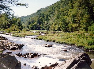
Falls of the Little River (Floyd County)
At the end of this course, you'll be able to integrate information from different disciplines to answer the question, "What makes Virginia special?" and to use your new understanding when you choose the location of your next residence or job.