Stuff to Know
- A brief excerpt from the Department of Mind-Numbing Numbers and Statistics - according to the 2010 Census data:
- Roughly 8 million Virginians lived in roughly 3 million housing units. (Are you "above average" and live in a housing unit with more people than the average Virginian? The math to determine the average is simple - 8/3=???)
- About 1/3 of Virginians were renters. That means about 2/3 of the people in the state lived in various sorts of dwellings that they owned - condominiums, townhouses, cabins in the woods, single-family residences on a 1/4 acre lot with a white picket fence and a dog...
- In the early colonial days, voting was restricted to people who owned property because much of the funding to provide government services came from taxes on property. The assumption was that property owners would tax themselves at a "reasonable" rate, but people without property would support an excessive expansion of government services - especially military expeditions to displace the Native Americans and open more land for settlement.
- Today, various government programs encourage purchasing a home. The assumption is that society will be more stable, allowing evolutionary change but deterring revolution, when 2/3 of the families have a large investment protected by the current economic, legal, and political system.
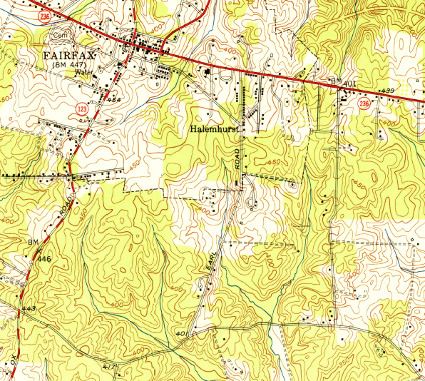
site of future George Mason University Fairfax Campus, in 1951
Source: US Geological Survey, 1951 1:24,000 quadrangle topo map
- Biggest and Smallest:
- Pittsylvania County is the largest county in the state, when"largest" refers to land area (nearly 970 square miles).
- Fairfax County is the Virginia jurisdiction with the largest population, over 1 million residents.
- The largest city in terms of population is Virginia Beach, with roughly 440,000 people living in about 450 square miles.
- The largest city in terms of land area is Suffolk, with 400 square miles.
- The City of Alexandria has the highest population density (almost 8,500 people/square mile), while Highland County has the lowest population density (6 people/square mile).
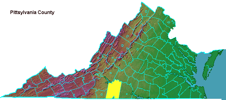
Pittsylvania County, Virginia's largest political jurisdiction in land area
(note boundaries of independent city of Danville on North Carolina border)
- Local Politics 101:
- In Virginia, cities are politically independent from counties. There are 95 counties and 38 independent cities, a total of 133 separate jurisdictions.
- The greatest expense for local governments is schools. With just a handful of exceptions, cities and counties operate separate public school systems. Consolidating schools might be more cost-effective, but the identities of many communities are tied to their independent school systems. (Witness the rivalries during football season...)
- Towns are part of counties, but towns are also separate jurisdictions with additional town taxes to pay for additional town services such as extra police patrols. There are 190 towns in Virginia.
- Residents of cities do not get to vote for county supervisors, and county residents do not get to vote in city council elections. If you live in the city of Fairfax, you vote for your city council representatives but you do not get to vote for county supervisors.
- Counties, cities, and towns have separate plans for land use. Long-range plans and zoning can be very different on either side of the political boundary. If local officials choose not to cooperate, a county can authorize noisy industrial uses right next to the area zoned by a city for a quiet subdivision.
- To ensure coordinated planning of roads and transit projects, the Federal government has mandated regional planning so transportation projects won't stop at political boundaries. To get Federal funding, Northern Virginia jurisdictions must coordinate with DC and suburban Maryland through the Metropolitan Washington Council of Governments.
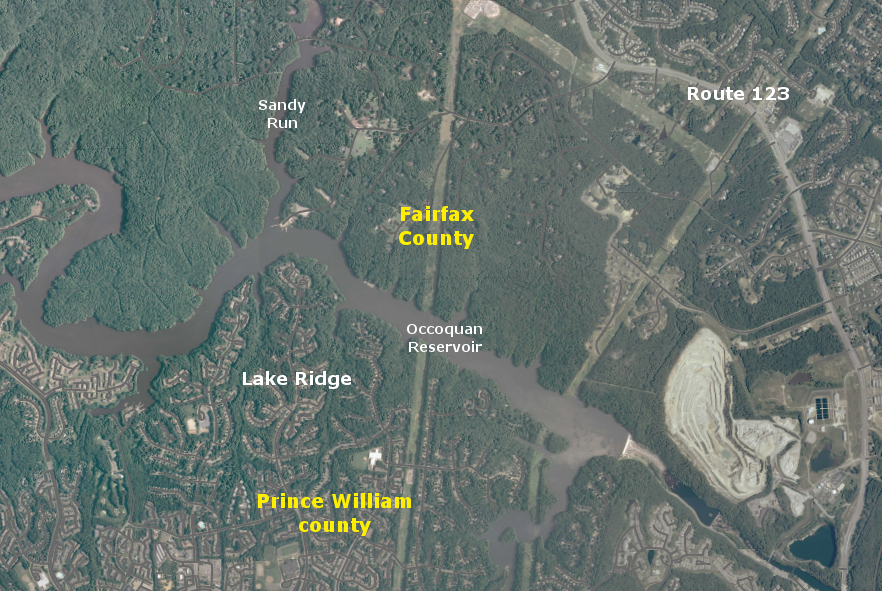
Occoquan reservoir in 2010, showing how land use planning in 1980-2000 led to parkland in Fairfax County vs. subdivisions in Prince William County
Source: US Geological Survey (USGS), Occoquan 7.5x7.5 topographic quadrangle (2010)
- Political boundaries change; counties and cities can disappear.
- The last Virginia county was created in 1880 (remember "Virginia's Baby"?), but political boundaries of many counties have changed since then.
- Some counties have "disappeared" as the General Assembly has revised county boundaries, changed names, and allowed counties to change their status into independent cities.
- Cities can expand their boundaries by annexing land from adjacent counties, even if the county objects. However, cities can not annex land involuntarily from other cities. If a county became a city, it could block annexation.
- Counties in southeastern Virginia have incorporated as cities, or merged with cities, to block efforts by Norfolk and Newport News to grow through annexation.
- Warwick County and Newport News merged, consolidating two jurisdictions to minimize political disputes. Hampton refused to join them, and merged with Elizabeth County instead.
- Princess Anne County took a different approach. It converted to become the City of Virginia Beach in 1963, stopping all future efforts by Norfolk to annex portions of the county into the city.
- In the last 20 years, three cities in Virginia have abandoned their independent status.
- The cities had become concentrated pockets of low-income residents. Revenue to fund schools and other services was inadequate, but increasing property tax rates even higher would made it impossible to attract new businesses that would generate additional tax revenue.
- The solution was to became a town, reuniting with the county and spreading the burden so county taxpayers helped fund town services.
- South Boston gave up its city charter in 1995, Clifton Forge in 2001, and Bedford in 2013.
- Charlottesville has threatened to convert to town status, which would force Albemarle County taxpayers to share the costs of social services and schools. To prevent this, Albemarle County agreed to share revenue, essentially subsidizing the city budget so Charlottesville would not become a town.
- Martinsville and Petersburg are the cities in greatest economic stress now, and considering reversion to town status.
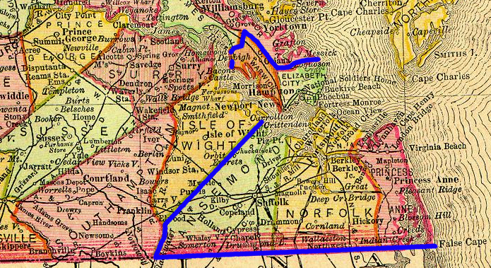
since World War II, every political jurisdiction in southeastern Virginia has altered its status and/or boundaries
Source: 1895 map of Virginia from the Color Landform Atlas of the United States
- Local Taxes 101:
- The separate elected officials in cities and counties approve separate property tax rates. 133 separate counties and cities have 133 separate tax rates - and the towns have even more taxes.
- The property tax rate on houses in Fairfax County in 2016 was $1.130/$100 in assessed value. That means homeowners paid the county 1.13% of their home's value. If you lived in the City of Fairfax, the 2016 property tax rate was $1.062/$100.
- In Northern Virginia, the value of property is assessed annually, so the amount of property taxes paid each year will fluctuate based on tax rate and assessed property value.
- Rates change annually when local jurisdictions adopt budgets. So do the values of homes, based on the real estate market.
- Politicians love to advertise "we cut taxes" when property values are rising. Rates can be lowered but revenue will not be reduced (because total property taxes = rates x assessed value), so government services stay fully-funded. However, homeowners paying attention will recognize they are writing a check for the same total amount in taxes.
- In 2015, the Fairfax County property tax rate was higher - $1.090/$100 vs. $1.130/$100 in 2016. Does that automatically mean that homeowners paid less taxes in 2016?
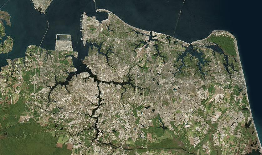
if urban/suburban land use blends together without rural farmland separating cities, why should separate political boundaries between Norfolk/Portsmouth/Virginia Beach be maintained?
Source: ESRI, ArcGIS Online
- Virginia is a "Dillon Rule" state, where local jurisdictions only have the authorities that were specifically granted by the General Assembly.
- Under Virginia law, cities have been granted more authority to levy taxes. For example, city councils can add a special tax on meals, above and beyond the normal sales tax, by a simple vote of the city council. Every Virginia city imposes a meals tax. In the City of Fairfax, there's a 4% tax added to every restaurant and fast food meal.
- Elected officials like the meals tax because it generates additional revenue from non-residents, and people who own houses *and vote in the city* can pay lower property taxes.
- The General Assembly did grant to most counties the authority to impose a meals tax, but local county supervisors must get approval by the local voters.
- New taxes are rarely popular, even if 25-30% of the people who would pay a meals tax are non-residents.
- Fairfax County voters overwhelmingly rejected a meals tax in 1992, as did Loudoun County voters in 2008. In 2013, voters in Henrico and Middlesex counties approved a new meals tax, but Chesterfield County voters rejected one. Fairfax County is voting on the meals tax again on November 8, 2016.1
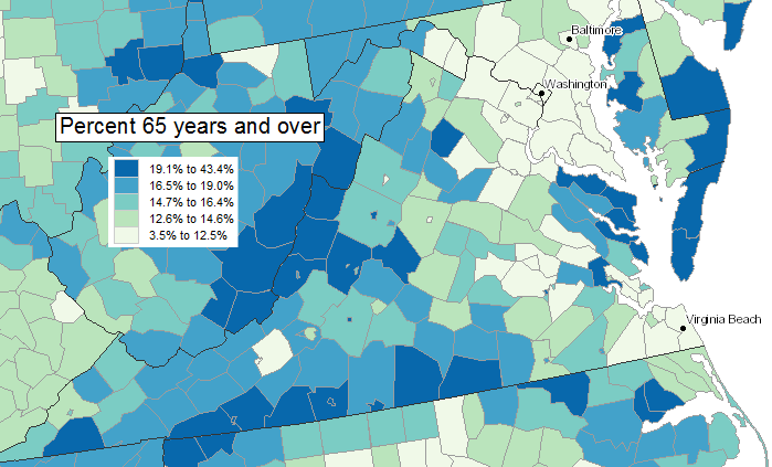
the western half of Virginia has a higher percentage of older people - think young people after high school have migrated to the urban areas in Northern Virginia, Richmond, and Hampton Roads, or did retirees move to the country?
Source: Bureau of Census, Census Data Mapper (2013)
- The Census Bureau website is rich with data about Virginia, but most of it is too confusing to cover in this class.
- Numbers can make you sound like you know what you are talking about, but there is a reason why economists refer to "lies, damn lies, and statistics." You still must use your brain to evaluate the numbers.
- Looking at map below:
- Is Highland County rural with low population density, or an urbanized area?
- If population density in Frederick County and City of Winchester has increased to the point where you might consider them part of Northern Virginia, think northern Fauquier County should be omitted, even though it is closer to DC?
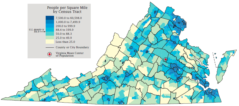
Virginia population density in 2010, by Census Tract, shows Virginia's rural areas (with low-density population) and the urban areas (where people are concentrated together)
Source: Bureau of Census, 2010 Census: Virginia Profile
- You can use Census data to identify the average number of people occupying a residence - but what does the graphic below tell you?
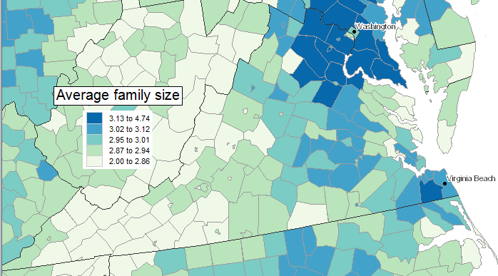
average family size in different Virginia jurisdictions (2013)
Source: Bureau of Census, Census Data Mapper
- One posibility: people living in Northern Virginia have more children living at home with them, compared to southwestern Virginia.
- Perhaps Northern Virginia has substantially more immigrants whose culture encourages large families?
- Another possibility: cost of housing is high in urbanized areas of Virginia. Maybe people with single-family residences rent rooms to help make monthly mortgage payments, and young workers rent rooms to minimize their rent costs?
- My guess: children are fleeing rural Virginia and moving to urban areas to find jobs and fun times In Northern Virginia, children are living at home even after graduating from college because of the high cost of living. Another Census map offers a clue regarding that hypothesis: the average age in Northern Virginia is younger.
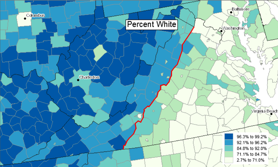
racial diversity is lower west of the Blue Ridge in Virginia - think that affects voting patterns?
Source: Bureau of Census, Census Data Mapper
- The map below shows Highland County has a high percentage of over-65 residents. It is a popular place for retirees who move from Northern Virginia to avoid the traffic and enjoy the scenic vistas.
- In contrast, the high percentage of over-65 residents in the counties on the North Carolina border reflect the collapse of the textile and furniture industries, and the decline in growing tobacco as fewer people choose to smoke.
- With few local job opportunities, you might conclude that young people are migrating from Southside Virginia to urban areas along the I-95 corridor and in Hampton Roads to find work.
- On the other hand, maybe the people in Pittsylvania and Halifax counties just have fewer children, but residents in Arlington County have many kids. Look again at the map above that displayed average family size - are families in Arlington County larger than average?
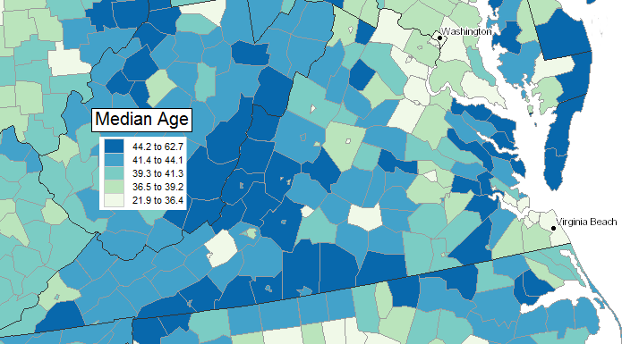
median age in different Virginia jurisdictions (2013)
Source: Bureau of Census, Census Data Mapper
- The most convenient Census tool is QuickFacts. It provides statistical data about each political jurisdiction in the United States.
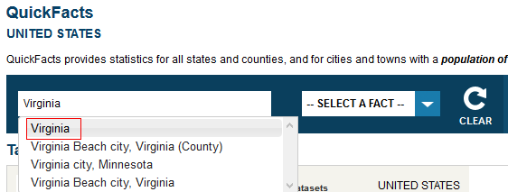
- Remember, cities and counties are different. That creates confusion for one place name in particular - check out what QuickFacts says about the county of Richmond (with 9,000 people) vs. the city of Richmond (with over 220,000 people).
- Ditto for Fairfax county and Fairfax city. (Hint: be prepared for a quiz question that asks you to compare data from two jurisdictions that have similar-sounding names.)
- In most states, cities are also part of counties, townships, or other local governments. Virginia is the only state in which every city is independent, separate from surrounding counties. The Census Bureau uses confusing terminology, and may refer to Virginia "cities" as "counties."
- "CDP's" are Census Designated Places, a statistical tool used by the Census Bureau. CDP's are not aligned with political boundaries. Do not confuse CDP's with political boundaries of towns, cities, and counties.
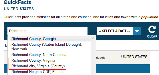
choose the correct "Richmond"
- You can use QuickFacts to determine if specific jurisdictions are growing faster or slower than other places.
- Population growth makes traffic congestion worse and creates crowded classrooms in schools, as suburban sprawl envelopes Prince William, Stafford, and Chesterfield counties.
- The option to "stop development; save the trees" does not exist. There are no gates at county/city boundaries blocking people from moving into a jurisdiction.
- Local officials can shape where growth occurs through zoning, by authorizing construction of new single-family houses in one area and facilitating development of high-density townhomes, apartment complexes, and condominiums in other places.
- "Smart Growth" advocates encourage zoning for high-density housing next to bus and transit/commuter rail routes to minimize future commuter congestion, and zoning for minimal new house construction in areas on the periphery of the urbanized area.
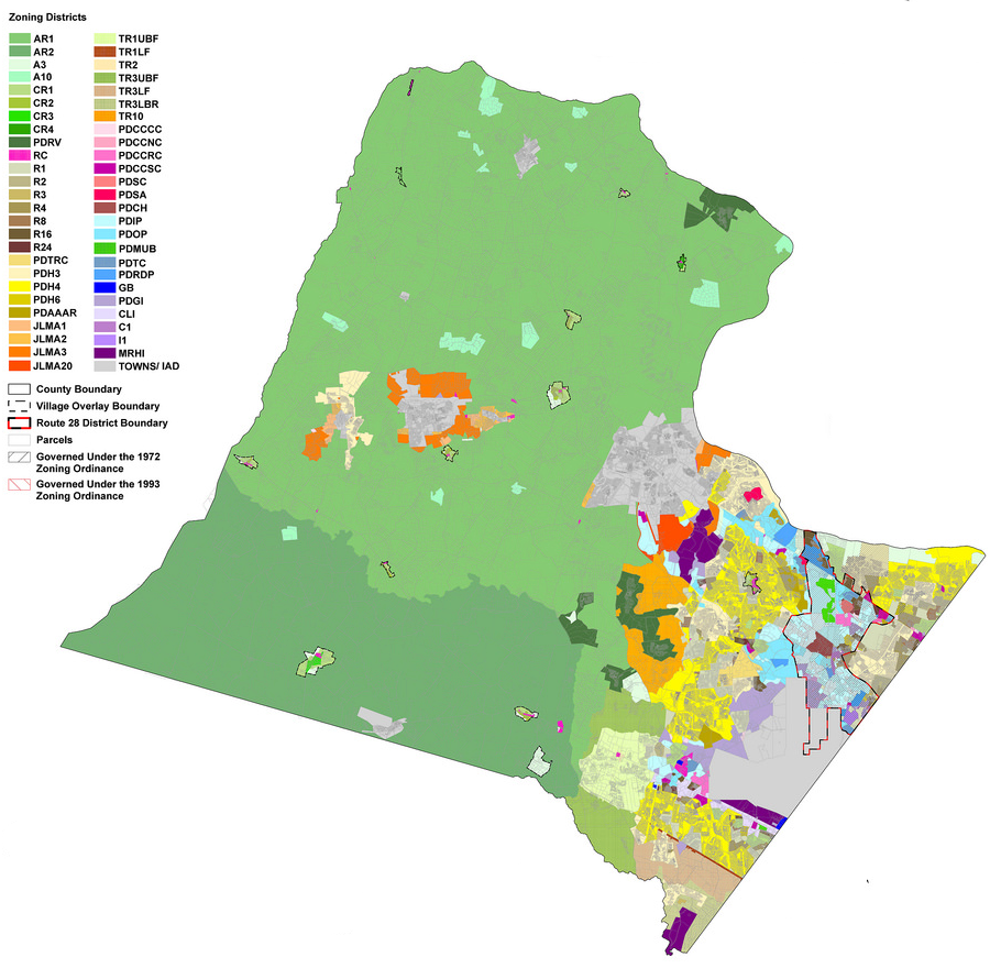
Loudoun County has used zoning to encourage agriculture and limit new housing on the western end of the county (colored green), and to encourage housing closer to the jobs concentrated in the urban area
Source: Flicker, Revised 1993 Base Zoning, 2015
- Some jurisdictions in Virginia are shrinking in population, emptying out.
- Check out the "Population, percent change - April 1, 2010 (estimates base) to July 1, 2015" for Buchanan County on the Appalachian Plateau vs. Loudoun County in Northern Virginia.
- When employment in the coal industry dropped due to mechanization and reduced demand, the Appalachian Plateau counties had no alternative sources for jobs. The economy was like a one-legged stool, based on just one business.
- Northern Virginia has benefitted since 1917 from increasing Federal jobs, as the government expanded in response to World War I, the Great Depression, World War II, and the Cold War. Think the economy in Northern Virginia is as dependent upon one industry as the economy on the Appalachian Plateau?
- Local leaders in Dickenson and Tazewell counties would love to have some of the suburban sprawl problems.
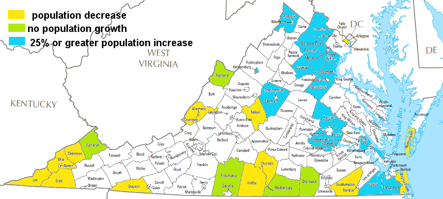
up to 2040, population is projected to decrease in several Virginia jurisdictions (yellow), stay level in others (green), and grow by more than 25% (blue) primarily in the urban crescent from DC to Hampton Roads
Source: based on projections from University of Virginia, Weldon Cooper Center, Virginia Population Projections
Map Source: US Geological Survey (USGS) National Atlas, County Map

the population in Northern Virginia jurisdictions continues to grow - but if the President and Congress chose to reduce expenses to balance the Federal budget, would population change in Prince William County resemble what Tazewell County has experienced?
Source: Bureau of Census, QuickFacts
- Why are population patterns so different in various regions of Virginia?
- using QuickFacts, compare a key educational attainment statistic, Bachelor's degree or higher, percent of persons age 25 years+, 2010-2014, for City of Danville vs. Fairfax county.
- if you were choosing where to locate a high-tech business, where would you go?
- The Census data shapes public policy. Business leaders in Danville have focused on creating training programs at the community college and with a consortium of universities.
- The Danville area has attracted a cluster of high-tech manufacturing companies to replace the textile, furniture, and tobacco-processing jobs that have melted away. If you buy Proctor and Gamble toothpaste, the toothpaste tube was probably manufactured in Danville.
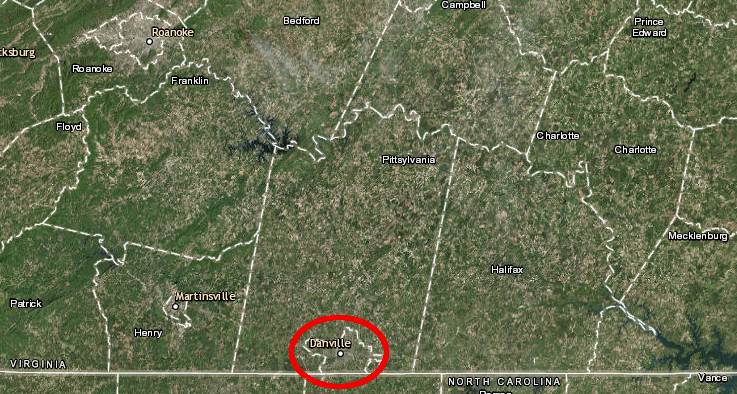
Danville and nearby jurisdictions have actively recruited Virginia colleges and universities to offer classes in the area, to improve educational attainment and attract high-tech manufacturing industries
Source: ESRI, ArcGIS Online
- Patterns of race are distinctive in Virginia, and date back to the patterns of agriculture during the colonial period.
- English colonists first used indentured servants to grow tobacco on plantations in Tidewater. After exhausting the fertility of the soil, new plantations were established in the Piedmont west of the Fall Line.
- The soils in Southside Virginia, south of the James River, grew the most tobacco. After 1700, most imported labor were slaves rather than indentured servants, and those slaves were concentrated in Southside.
- Most colonists who settled in Virginia west of the Blue Ridge in the 1700's came south from Pennsylvania. The Germans and Scotch-Irish typically were not slave owners.
- There were slaves west of the Blue Ridge, but little plantation agriculture. The big agricultural products were livestock (pigs and cattle could be walked to market in Philadelphia) and wheat, which required far less labor than tobacco.
- In the 1850's, railroads connected the Shenandoah Valley and Southwest Virginia to the port cities on the Fall Line. Low-cost transportation made it economically feasible to establish large plantations that depended upon slave labor to produce tobacco, corn, and other agricultural crops for sale. The salt-producing operations on the Kanawha River, and some iron furnaces, also relied upon slaves for low-cost labor.
- In 1850, many of the counties between the Blue Ridge and the Allegheny Front had only minor economic dependence upon slavery. If the Civil War had occurred in 1850 instead of 1860 and Virginia had been divided, counties west of the Blue Ridge might have been included in the new state of West Virginia.
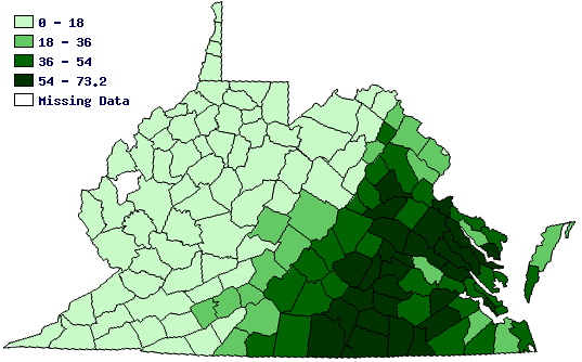
in 1860, the highest percentage of Virginia's population held in slavery was in Southside, and the lowest percentage was west of the Blue Ridge
Source: University of Virginia, Historical Census Browser
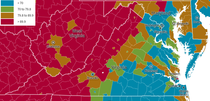
in 2014, most jurisdictions west of the Blue Ridge were at least 90% white, in contrast to communities east of the mountains
Source: Social Explorer, US Demography: 1790 to Present
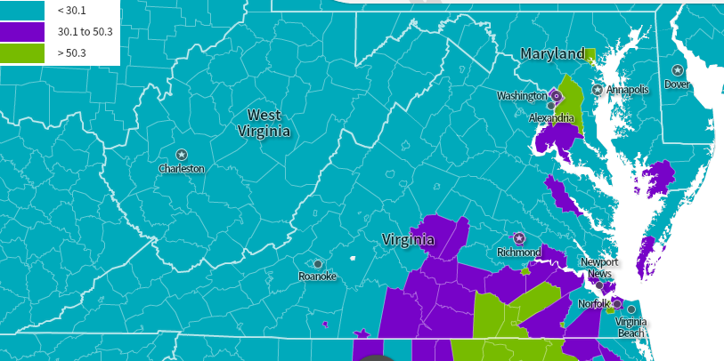
in 2014, the jurisdictions that were at least 30% black were concentrated in Southside Virginia
Source: Social Explorer, US Demography: 1790 to Present
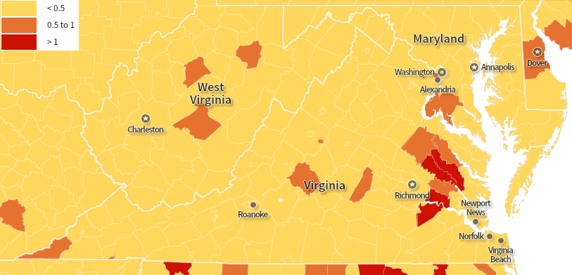
in 2014, four Virginia counties had more than 1% Native American population
Source: Social Explorer, US Demography: 1790 to Present
- Virginia now has 38 cities, along with 95 counties and 190 towns.
- Unlike other states, in Virginia the cities are totally independent from the counties. Cities and counties often partner together to create regional projects for water/sewer, landfills, jails - but the elected officials represent separate voters with separate interests.
- The City of Fairfax is a politically-independent unit separate from the County of Fairfax, with separate elected officials/taxes/land use plans/schools - even though the city is completely surrounded by the county. To make it even more confusing, a small chunk of land inside the city boundaries where the courthouse complex is located on Route 123 is still a part of Fairfax County.
- Residents in a town pay town taxes, in addition to county taxes.
- Towns, unlike cities, are part of the counties. If you live in Vienna, you pay Fairfax County taxes and get to vote for members of the Fairfax County Board of Supervisors - and you also pay Vienna taxes and get to vote for Vienna Town Council. If you live in the city of Fairfax, you do not pay county taxes or vote for county officials even though Fairfax County completely surrounds the city.
- There are three incorporated towns within Fairfax County, with town councils and additional town taxes for town services: Vienna, Herndon, and Clifton.
- Reston, Lorton, Burke, and Springfield are not towns within Fairfax County. There are no elected town councils for those communities.
- Tysons is not a town either. That location developed after construction of the Beltway (I-495). The Beltway created a combination of roads (Route 7, Route 123, and the new interstate) that linked Dulles International Airport, the CIA/Pentagon, and downtown DC with the workers/shoppers living in the suburbs of Maryland and Virginia.
- Today Tysons is a dense, urbanized area on the edge of the central core of DC. It is often called an "Edge City," but there is no city boundary or mayor of Tysons.
- Towns can be larger than cities. Virginia Tech is located in a town (Blacksburg) with 44,215 residents in 2015, while Radford University is in a city (Radford) with 17,403 people.
- Towns have independent authority for planning and zoning. Town and county officials can have very different visions of how to develop along the edge of a town, or the officials can cooperate on zoning land for housing, commercial, and industrial uses.
- The Fairfax County courthouse complex on Route 123 is still part of the county, even though Fairfax City completely surrounds the complex. The county controls the zoning on that "hole in the doughnut," not the city.
- State officials in Virginia do not have zoning authority. They can not force counties, cities, and towns to cooperate on land use. With a few exceptions, state officials can not mandate that local officials rezone farmland to allow a shopping center or subdivision.
- In other words, if you care about whether the patch of trees on your street will be cut down to become new houses or a McDonald's, then pay attention to your local elections. Get to know your county supervisors or town/city council. Those officials make the decisions that affect your neighborhood. Election campaigns for the state legislature (General Assembly), the US Congress, and the President get all the attention, but zoning decisions are local decisions.

the town of Blacksburg has more residents than the city of Radford
Source: Bureau of Census, QuickFacts
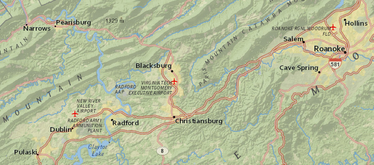
within Radford's city boundaries, the City Council makes the land use decisions and determines through zoning whether a parcel can be developed with houses or as a gas station
Who makes those decisions in Blacksburg? Who makes those decisions for the portion of Montgomery County that separates the town and the city?
Source: ESRI, ArcGIS Online
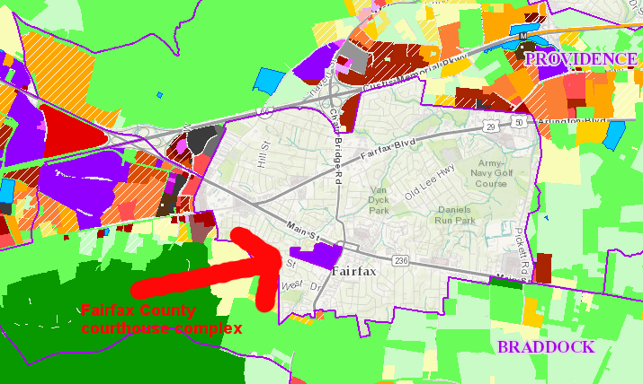
inside the boundaries of the City of Fairfax is an isolated chunk of Fairfax County, and zoning for development of that chunk (the courthouse complex) is controlled by the county
Source: Fairfax County, Planning & Zoning Viewer Map
- The suburban counties around Richmond have very different political priorities than the urban city, and those priorities reflect socio-economic patterns.
- Richmond is 40% white, has a median household income of $39,445, and over 26% of residents have incomes below the poverty level.
- Chesterfield is 70% white, has a median household income of $72,363, and less than 8% of residents have incomes below the poverty level.
- In the 2012 presidential election, 78% of the City of Richmond voters vs. 45% of the Chesterfield County voters supported Barack Obama.
- Not surprisingly, Richmond and Chesterfield officials have difficulty working together on sharing costs for regional projects, such as the Greater Richmond Transit Co. bus system. Chesterfiekd and Richmond each own 50% of the system, but almost all routes serve just Richmond residents (and some in neighboring Henrico County). Chesterfield officials support only a few commuter routes into the city, and do not encourage a reverse commute by city residents into the county
- Chesterfield County officials claim their population density is not sufficient to justify a subsidy for expanding bus services. Others have suggested socio-economic differences are the root cause, and the county wants to minimize the opportunities for more low-income, minority workers to move into the county or commute to jobs along Route 1 (Jefferson Davis Highway) or Route 60 (Midlothian Turnpike).2
- Plans to replace the current ballpark for a AA baseball team in Richmond reveal the different priorities. Richmond's mayor wanted to relocate the ballpark to the city's downtown area. He hoped to spark economic revitalization, similar to how the Washington Nationals ballpark has transformed Southeast DC. Chesterfield and Henrico counties had little interest is helping Richmond attract businesses that might otherwise locate in those suburban counties, and declined to offer funding for building a new ballpark in downtown Richmond.
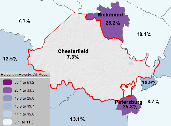
most Virginia cities are concentrations of low-income and minority residents and Census statistics show a clear socio-economic contrast with surrounding suburban counties:
the percentage of people living below the poverty level in Chesterfield County is far less than in Richmond to the north or Petersburg to the south
(use the Virginia Atlas and Gazetteer to identify the other jurisdictions on this map)
Source: Bureau of Census, Small Area Income and Poverty Estimates
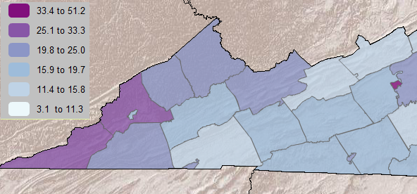
in Southwest Virginia, the City of Norton has a smaller percentage of people living below the poverty level than surrounding counties - but look at Radford vs. Pulaski County
Source: Bureau of Census, Small Area Income and Poverty Estimates
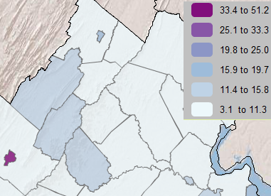
compare the pattern of poverty in Northern Virginia cities vs. surrounding counties (and Harrisonburg vs. Rockingham County)
Source: Bureau of Census, Small Area Income and Poverty Estimates
Week 9: "We the People" - Politics and Government of Virginia
Class Syllabus and Schedule
Geography of Virginia


