
the evolution of Virginia's topography over the last billion years can be simplified to "Virginia is bumpy in the west, flat in the east"
Source: Ray Sterner, Color Landform Atlas of the United States

the evolution of Virginia's topography over the last billion years can be simplified to "Virginia is bumpy in the west, flat in the east"
Source: Ray Sterner, Color Landform Atlas of the United States
Note the differences in the topography, the shape and features of the surface of the state. (The graphic above is oriented with north at the top, but that will not be true of every map we examine.)
Look closely at the far southwest, where I drew a white line to mark the extension of the Appalachian Plateau into Virginia. The bumpy west is not equally bumpy everywhere. The Appalachian Plateau is relatively flat, compared to the Valley and Ridge province just to the east.
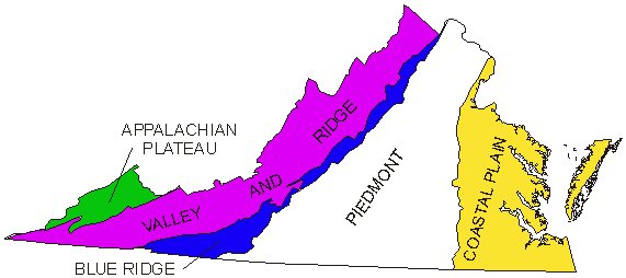
the Appalachian Plateau is one of five physiographic regions in Virginia
Source: US Geological Survey (USGS), Ground-Water Dating to Assess Aquifer Susceptibility
Virginia is normally subdivided into five "physiographic provinces," which use bedrock geology and surface topography to classify diferent regions.
At the most simple level, you can divide Virginia into two parts and draw a line separating the flat east from the bumpy west region of the state. Go west across the state, about 2/3 of the way from Washington DC in Northern Virginia, and you'll cross the Piedmont into the Blue Ridge.
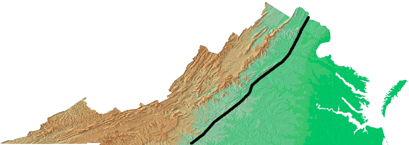
Where you draw the line between foot and mountain is a judgment call. Would you draw the line closer to the mountains, indicated in brown in the map above? (Don't let teachers and "experts" make all the decisions for you...)
Geologically, all of the route of I-66 across northern Fauquier County, the stretch from Route 17 to Front Royal, is in the Blue Ridge. Culturally, some people choose to say they reach the Blue Ridge on I-66 only when they get near the northern tip of Shenandoah National Park. Resource managers include all of Northern Fauquier County in the Blue Ridge physiographic province; the soils and vegetation match other portions of the Blue Ridge. "Normal people" simply driving to Shenandoah can make a different choice.

between Thoroughfare Gap-Manassas Gap, I-66 crosses igneous and metamorphic rocks that are geologically part of the Blue Ridge, but topography is flat enough in the middle for one town to be called The Plains
Source: US Geological Survey (USGS), National Map Viewer
In what physiographic region would you place Hurt, Virginia?
Look it up in the Virginia Atlas and Gazetteer, then get a map by finding it via the Geographic Names Information System... or use Google if you prefer.
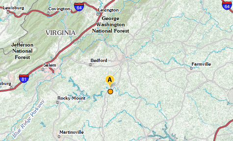 in what physiographic province is Hurt, Virginia located? Source: US Geological Survey (USGS) National Map |
The "duh, simple..." challenge is to decide whether Hurt belongs in flat or bumpy Virginia. After you study the specific physiographic provinces, decide if you would consider Hurt to be in the Piedmont or the Blue Ridge. If you're a geologist, you'd say Hurt is located in the Smith River allochthon. That is a "terrane" or chunk of crust that was initially formed elsewhere, but thrust into its current locations by tectonic forces as island arcs collided with Laurentia roughly 400 million years ago.
The conventional wisdom is that there are five physiographic provinces used to categorize the regions of Virginia - but don't just memorize what other people have decided. It's OK to streeeeeetch a few brain cells of your own and create your own classification system, just like you can define your own constellations in the night sky. The Greek shepherds don't have a permanent monopoly on naming star patterns (Gemini looks like a Greyhound bus to me), but I'll be sticking with the standard names for physiographic provinces this semester.
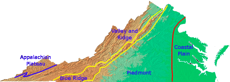
physiographic provinces of Virginia
Map Source: USGS Open-File Report 99-11, Color Shaded Relief Map of the Conterminous United States
On the ground, one easy topographic and geologic feature to recognize is the Blue Ridge. The color and character of the Blue Ridge volcanic rocks are distinct, especially compared to the gray sedimentary limestones in the Shenandoah Valley further west.
Limestone is the typical bedrock in the Shenandoah Valley and other valleys in the Valley and Ridge province. Limestone comes in different shades of gray, grey with streaks of white (calcium carbonate with fewer impurities), or grey with streaks of brown from iron staining. There may be 50 shades of grey, but looking at it can get rather monotonous.
Ever visit the Virginia Tech campus is at Blacksburg, located in the Valley and Ridge physiographic province? The architecture there is Collegiate Gothic, and the buildings are made of grey and grey-brown limestone from local quarries known as "Hokie stone." On overcast days during the drizzles of January/February, the constant bland, almost colorless grey building/grey sky can get quite depressing.
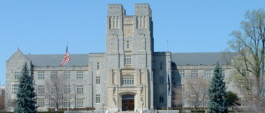
Burruss Hall, typical of Collegiate Gothic architecture at Virginia Tech
Source: Wikipedia, Virginia Tech College of Science
The Blue Ridge mountains may have provided a guide for the first Virginians to wander through 15,000 or more years ago. Gaps carved by rivers may have provided easy-to-find locations where scattered hunting bands agreed to gather, so they could discuss the best ways to make tools from stone and bone, trade for prestige goods, and arrange the Paleolithic equivalent of blind dates.
Currently, archeologists are studying a site at Leesville Lake where the Roanoke River reaches the Piedmont after cutting through Smith Mountain Gap. "Points" (spear tips, knives, etc.) have been excavated there which were made from stone that does not exist in the local area. We can figure out ancient transportation routes from the stone; someone carried those points from where the rock was first collected through Smith Mountain Gap.
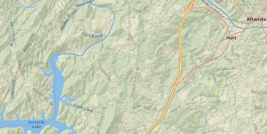
Leesville Lake is just west of Hurt
Source: ESRI, ArcGIS Online
Why gather at Smith Mountain Gap? There were no stores open 24-7 back then; people who wanted to trade had to pick a time and place. The dip in the Blue Ridge, cut through the mountains by the Roanoke River, was an easy-to-recognize place. Other gaps carved through the Blue Ridge by the James and Potomac rivers may also have been chosen as the let's-get-together place, at a time when everyone was concious of topography.
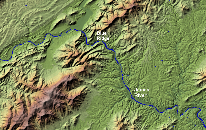
the James River carved one of the few water gaps through the Blue Ridge
Source: USGS Earth Resources Observation and Science (EROS) Center, National Elevation Dataset - Shaded Relief Map of Virginia
Native Americans crossed through the gaps, but their main trails were parallel to the Blue Ridge mountains on the east and on the west. The Iroquois who lived in what is now western New York state used those paths to travel south in the Fall, in order to hunt and to attack rival tribes.
Today, Interstate 81 follows the old Native American path on the western side. The equivalent on the eastern side of the mountains is Route 15 from the Potomac River to Gainesville, then Route 29 to Danville on the North Carolina border. (Get out your Virginia Atlas and Gazetteer or open up GoogleMaps to check 'em out.)
There was no Native American trail on top of the Blue Ridge. Skyline Drive and the Blue Ridge Parkway were make-work projects designed to increase employment during the Great Depression of the 1930's.

Politics as well as topography has affected where highways were constructed. When the interstate system was built, I-81 was designed to parallel Route 11, which followed an old colonial path south from the Potomac River to Bristol on the Tennessee border.
State officials provided much less north-south road access to the communities on the east side of the Blue Ridge; there is no mirror image of I-81. On the east side of the Blue Ridge, I-85 connects the middle of North Carolina to... Petersburg. That decision directed traffic and its economic benefits to the Richmond region, and Lynchburg was bypassed.
Even more damaging to Lynchburg, state officials did not route I-64 from Richmond west through Lynchburg to Roanoke. The low spot in the Blue Ridge where the Roanoke River cut a water gap was an obvious candidate for a new interstate highway to cross the mountains.
Instead, I-64 was built from Richmond to Charlottesville, then across the Blue Ridge at Rockfish Gap before joining I-81 south to Lexington (and then west into West Virginia). The odd dogleg route of I-64 between Charlottesville-Lexington benefitted the home town of former governor John Battle, who reportedly asked his friend President John F. Kennedy to ensure that Charlottesville got an interstate connection. Physical geography is a factor in where transportation corridors are located, but physical geography does not guarantee urban destiny...
Over 200 years ago, Lewis and Clark proved that the French concept of "symmetrical geography" was invalid on a large scale. The explorers of the American West discovered that the North American continent was not a flat sheet, with low Appalachian Mountains near the east coast and a mirror-image low mountain range near the west coast. Instead, there was a high mountain range (the Rockies) that were a barrier to transportation.
When it comes to the location of highways paralleling the Blue Ridge, business and civic leaders in Lynchburg are well aware that there is no symmetrical geography for the transportation network of their city.
