Waaaay back in elementary school, did you ever arrange blocks or jig saw puzzles with pieces shaped like the 50 states to make a map of the entire US? The Drag-and-Drop the States site offers a refresher to discover where Virginia is located in relation to the other states.
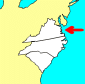
Its is a simple exercise - but when you get to Virginia, notice that the two counties between the Chesapeake Bay and the Atlantic Ocean (the Eastern Shore) were omitted. You'll see the two counties on the Eastern Shore have been omitted on lots of "small scale" maps designed for national orientation, rather than a state or local perspective.
Virginia is not alone in having part of the state amputated in various maps. The Upper Peninsula or "UP" of Michigan also gets left off many maps, even though it is 30% of that state's land area. A tourism commercial that omitted the UP caused an angry Michigan legislator to try to mandate in 2009 that all state-produced maps include the entire state.1

two counties on the Eastern Shore, Accomack County and Northampton County, are adjacent to Maryland
Source: Color Landform Atlas of the United States
1. National Public Radio - All Things Considered, "Mich. Bill Gives Upper Peninsula Some Respect," July 15, 2009, http://www.npr.org/templates/story/story.php?storyId=106658666 (last checked July 26, 2009)